

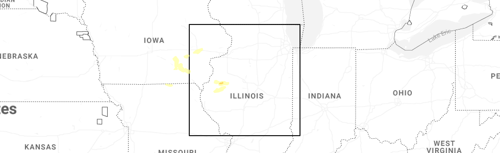
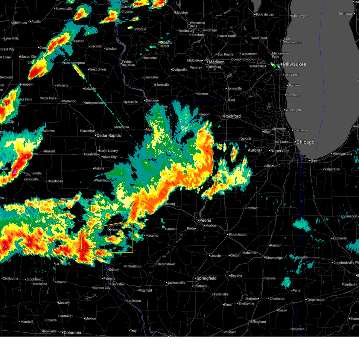
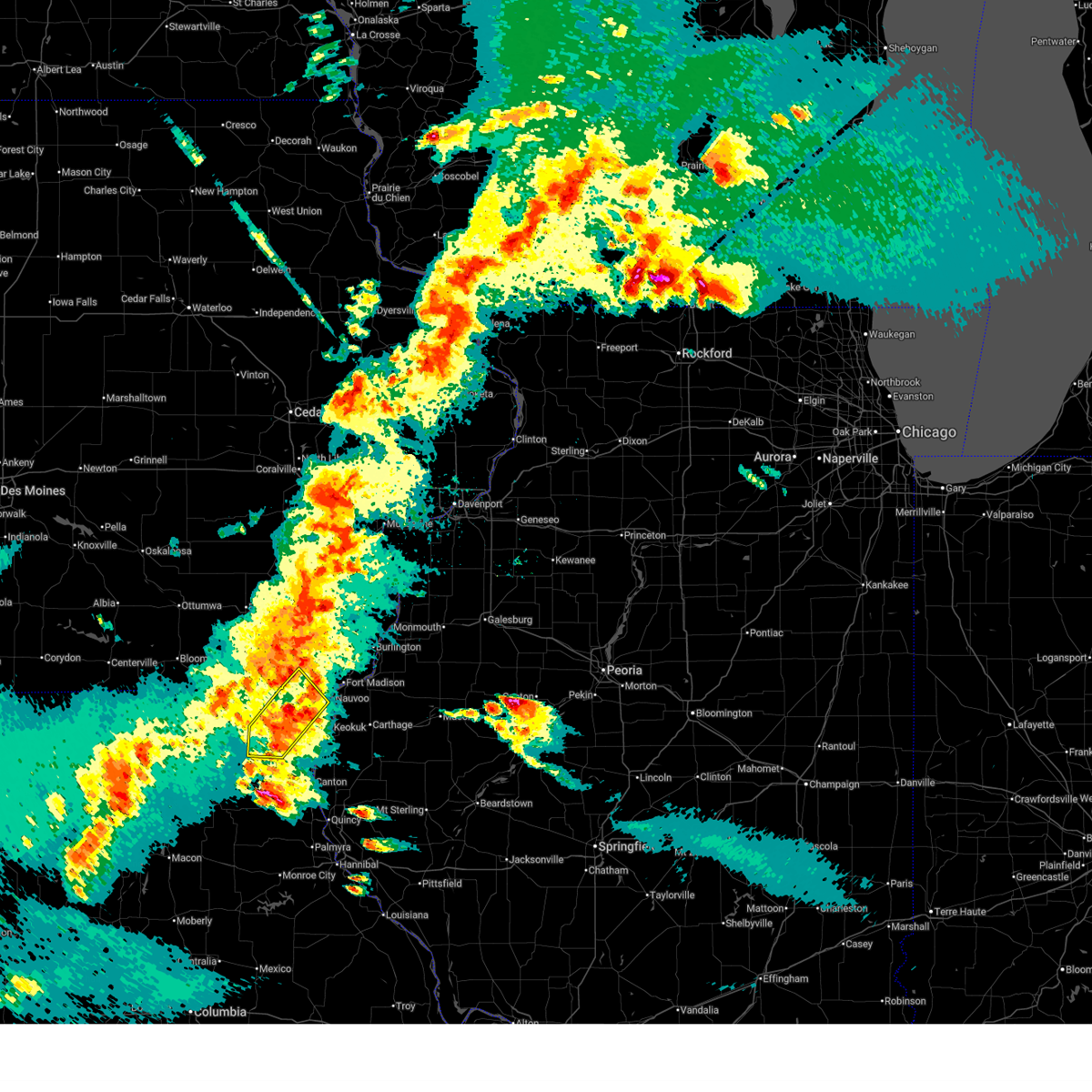
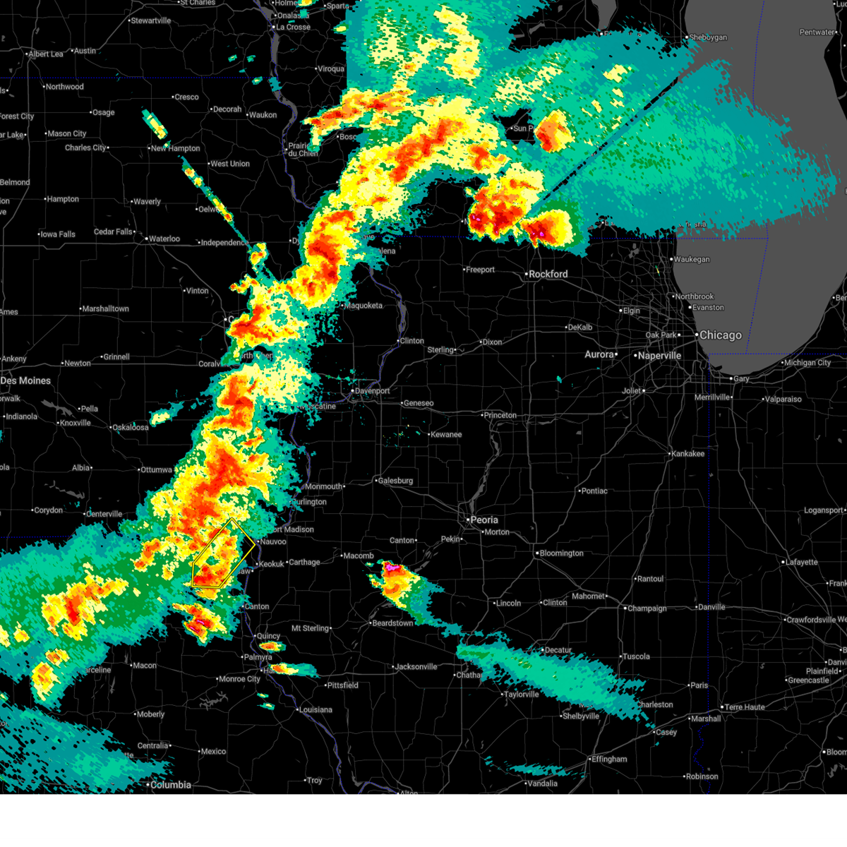
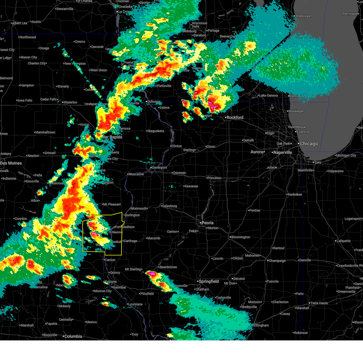
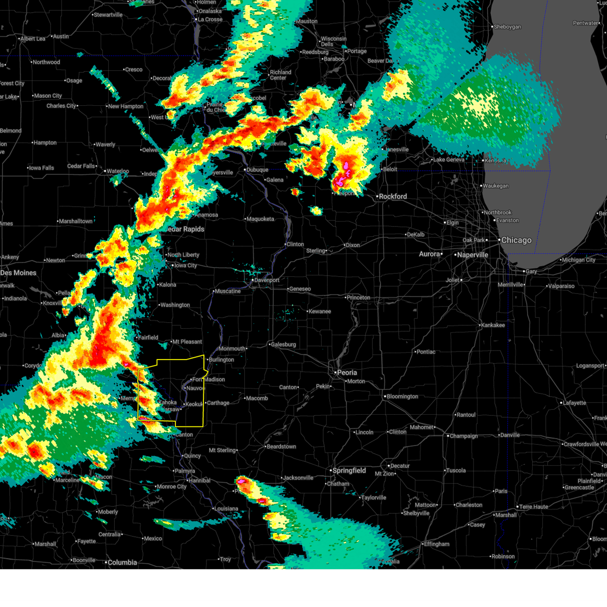
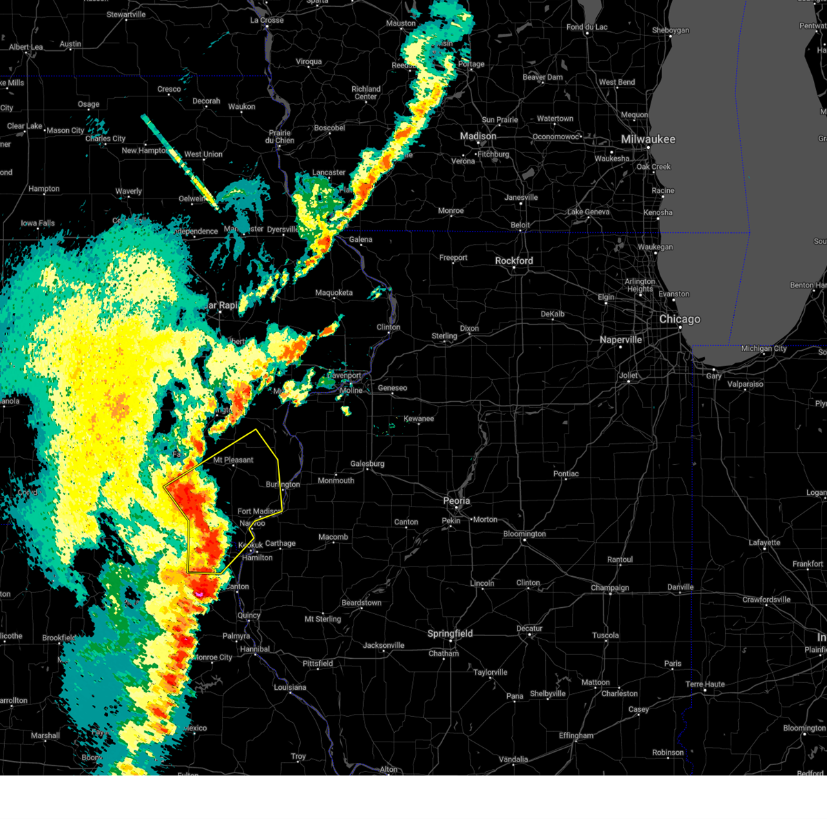
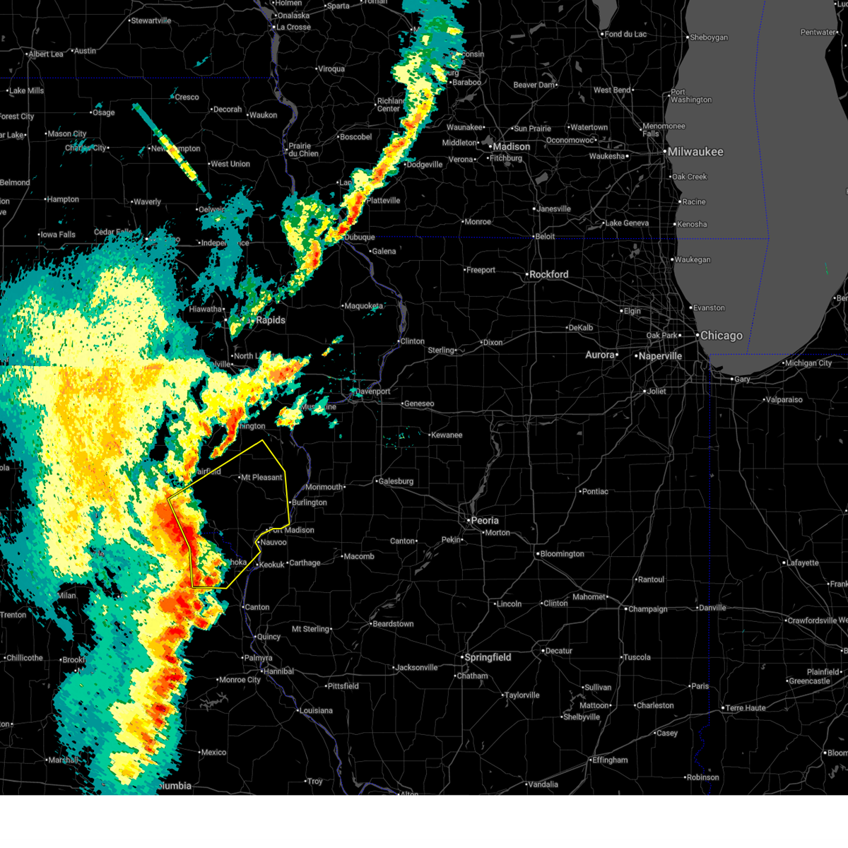
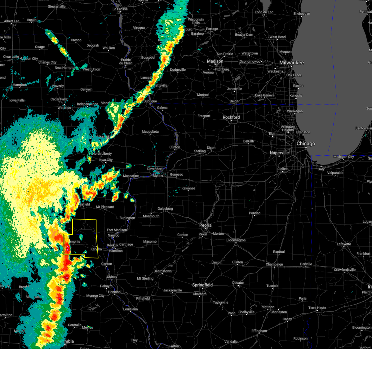
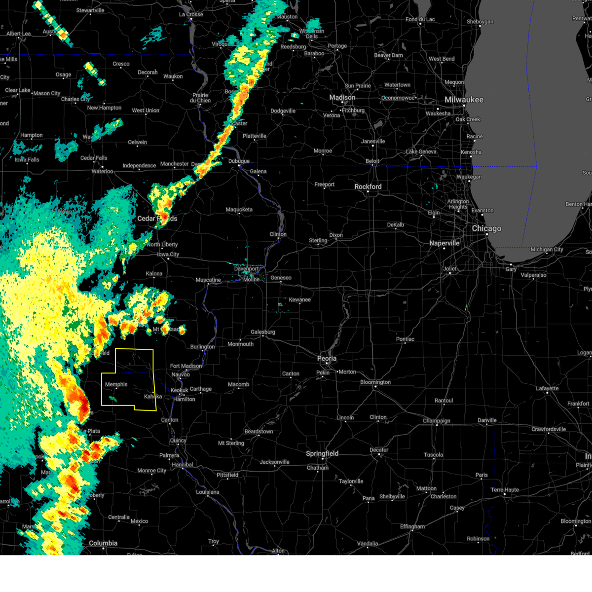
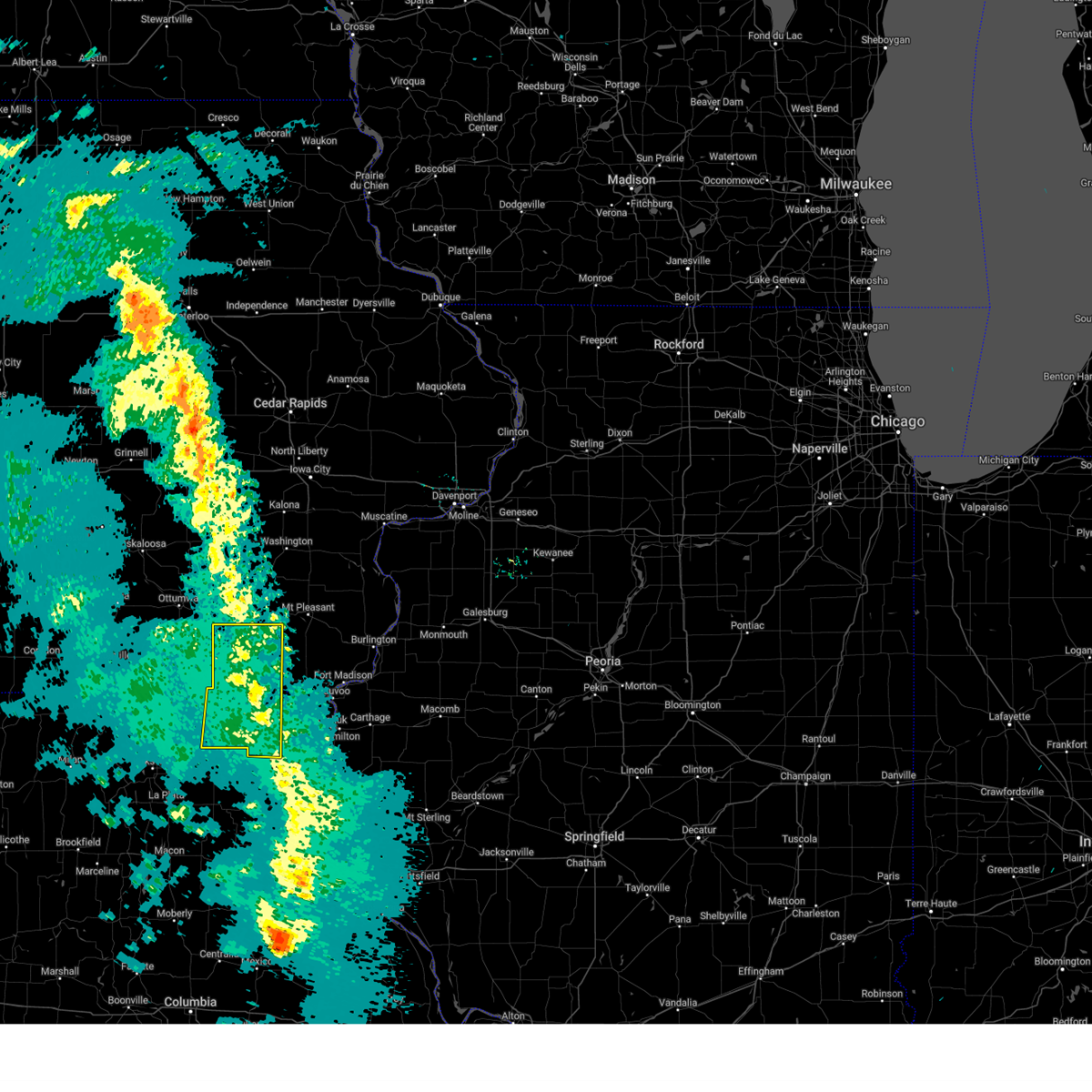
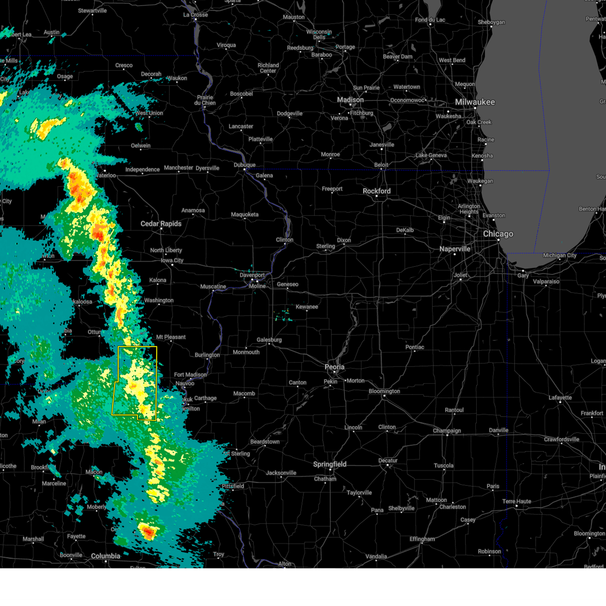
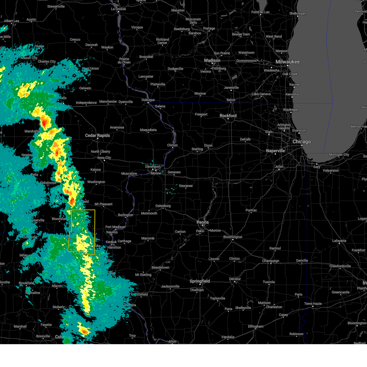
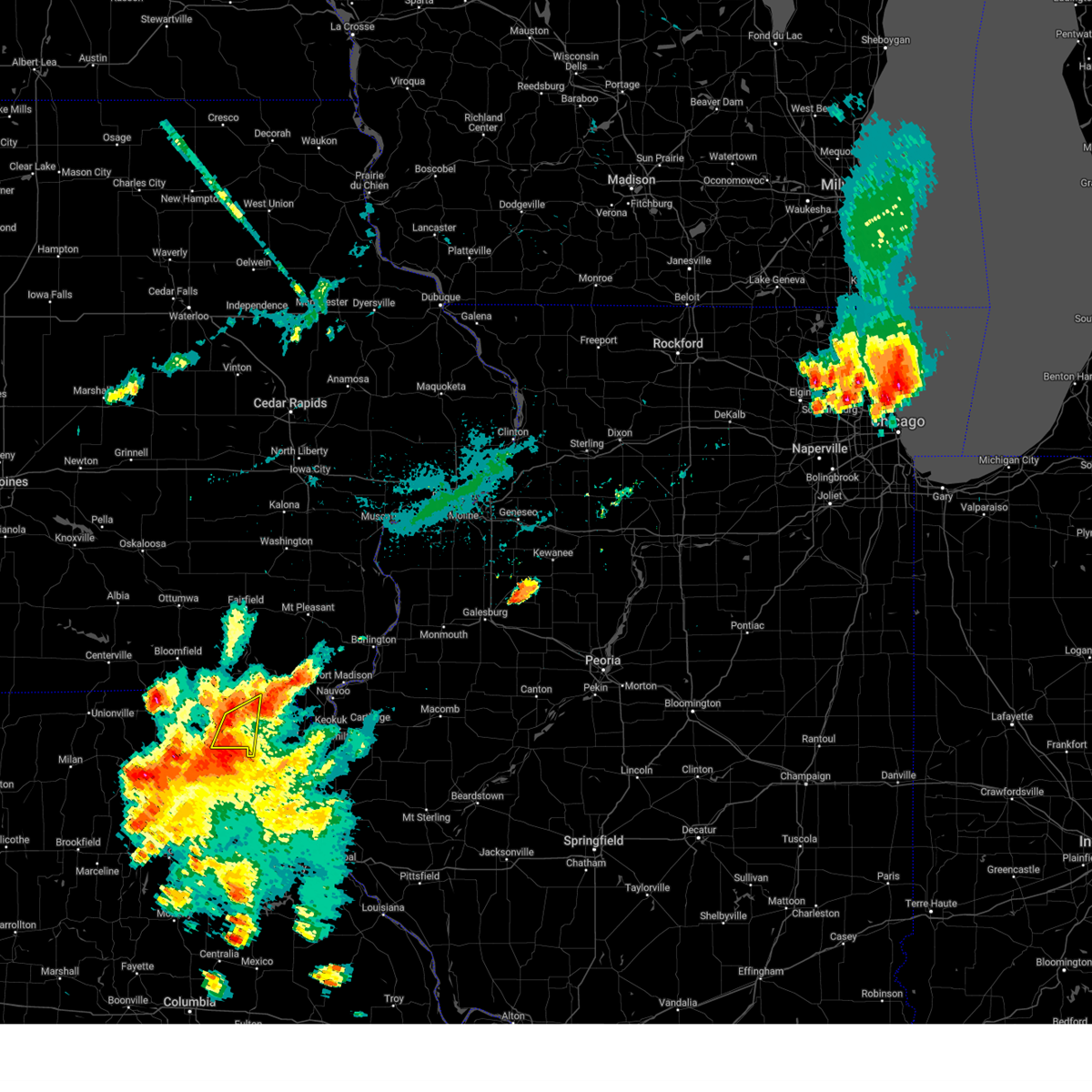
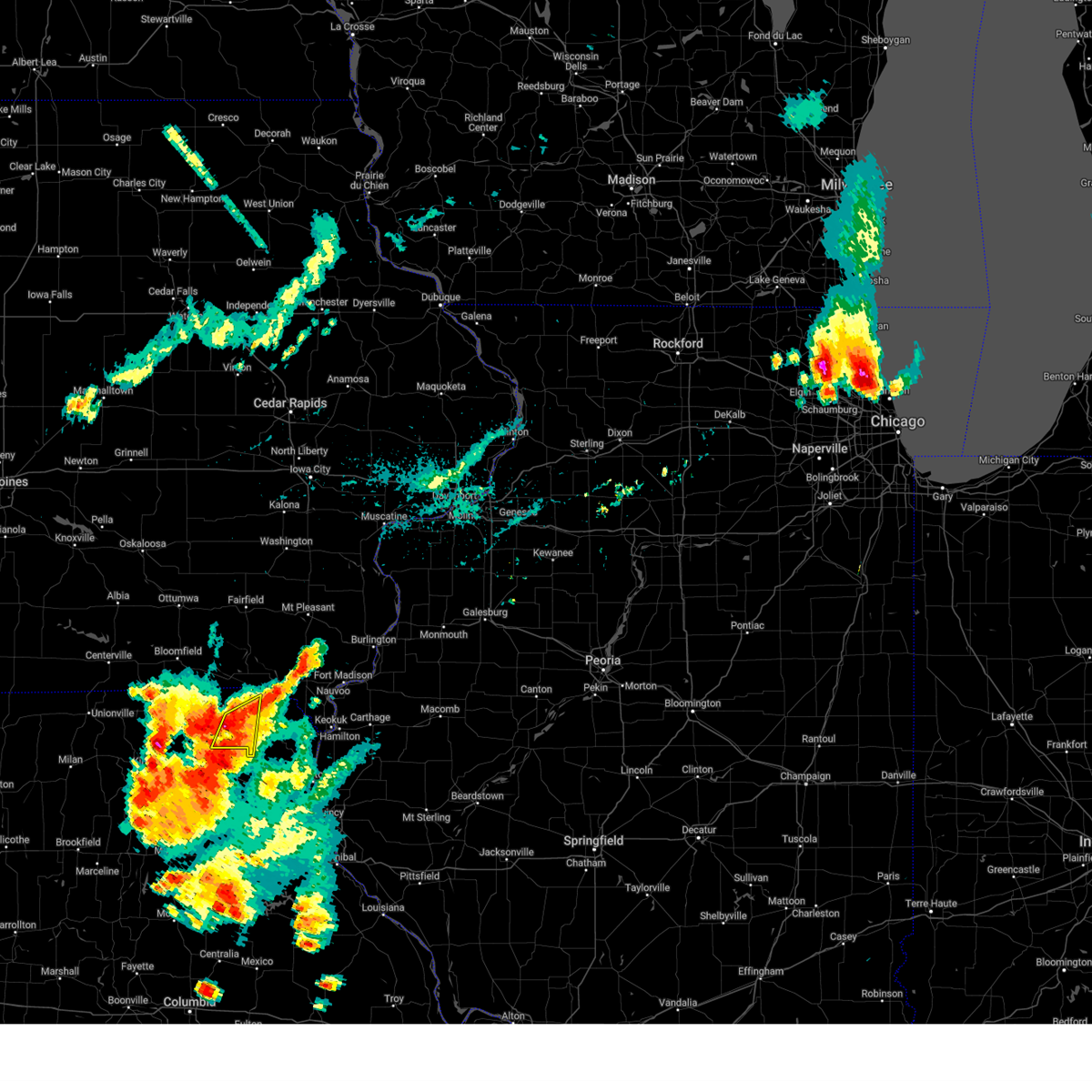
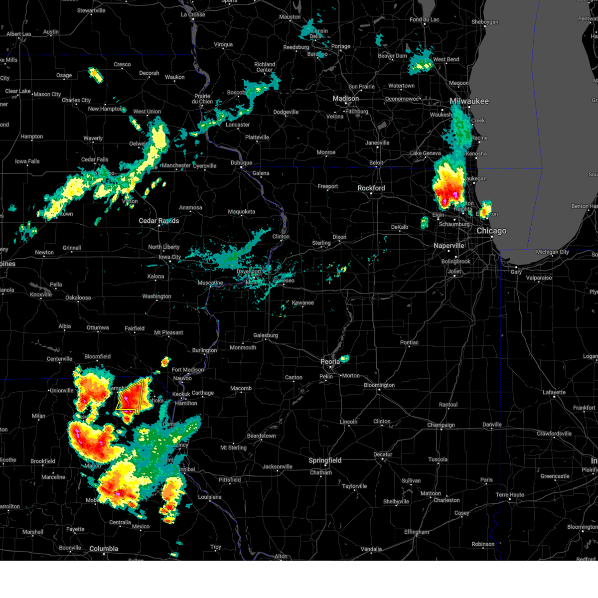
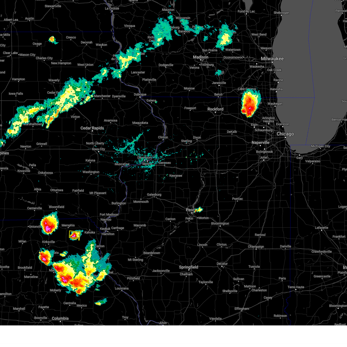
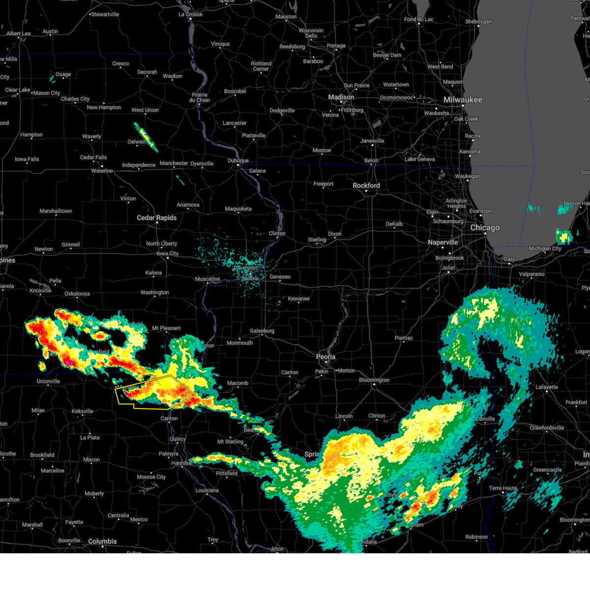
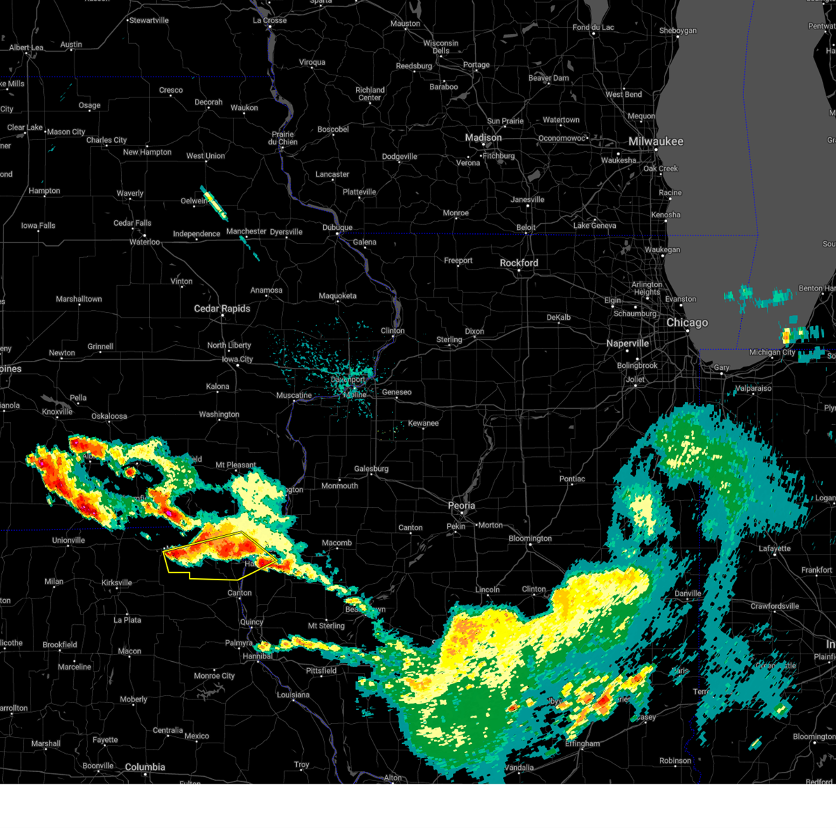
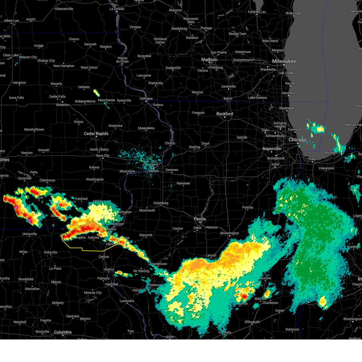
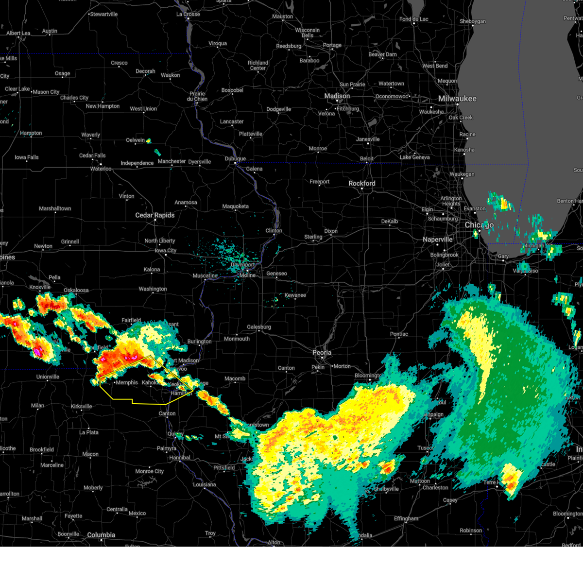
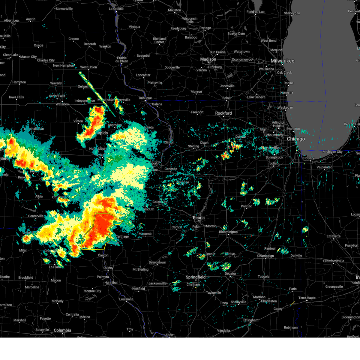
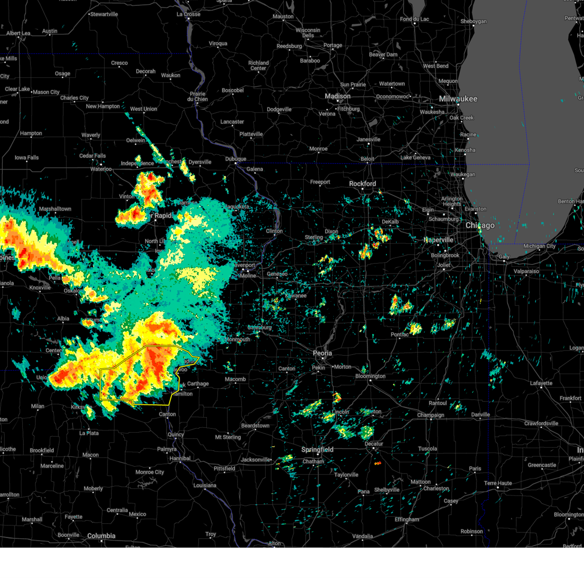
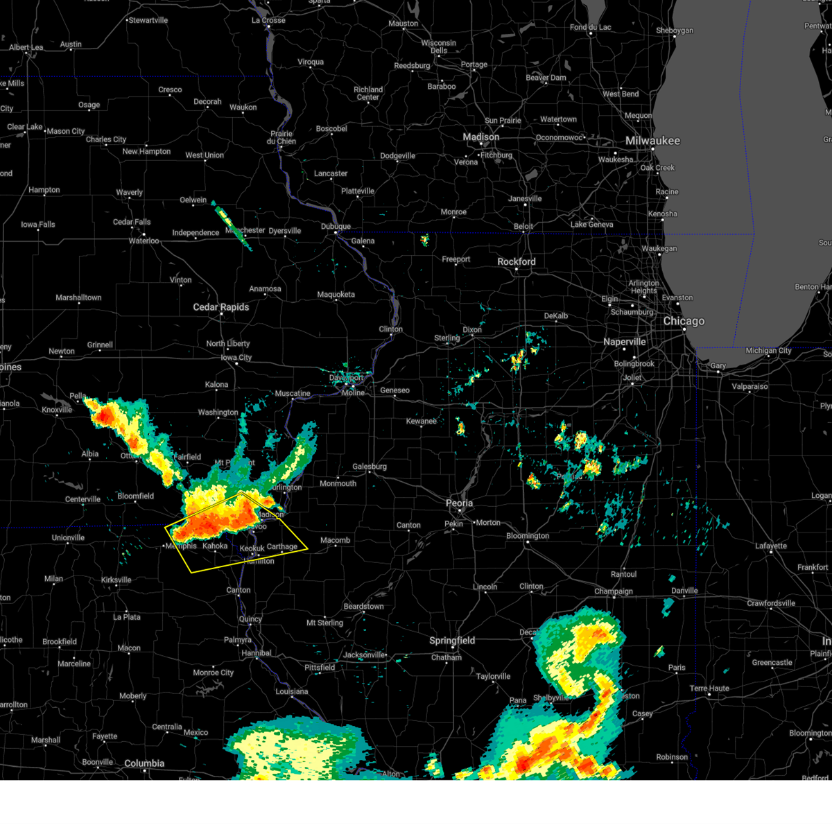
Hail Map for Wyaconda, MO
The Wyaconda, MO area has had 2 reports of on-the-ground hail by trained spotters, and has been under severe weather warnings 11 times during the past 12 months. Doppler radar has detected hail at or near Wyaconda, MO on 60 occasions, including 5 occasions during the past year.
| Name: | Wyaconda, MO |
| Where Located: | 11 miles W of Kahoka, MO |
| Map: | Google Map for Wyaconda, MO |
| Population: | 227 |
| Housing Units: | 140 |
| More Info: | Search Google for Wyaconda, MO |
2
The Top Recent Hail Date for Wyaconda, MO is Wednesday, June 17, 2026 (8th out of 60)
Hail and Wind Damage Spotted near Wyaconda, MO
| Date / Time | Report Details |
|---|---|
| 6/11/2026 3:41 PM CDT |
 Svrdvn the national weather service in the quad cities has issued a * severe thunderstorm warning for, scotland county in northeastern missouri, southwestern clark county in northeastern missouri, * until 445 pm cdt. * at 340 pm cdt, severe thunderstorms were located along a line extending from memphis memorial airport to near baring, moving east at 45 mph (radar indicated). Hazards include 60 mph wind gusts and penny size hail. expect damage to roofs, siding, and trees Svrdvn the national weather service in the quad cities has issued a * severe thunderstorm warning for, scotland county in northeastern missouri, southwestern clark county in northeastern missouri, * until 445 pm cdt. * at 340 pm cdt, severe thunderstorms were located along a line extending from memphis memorial airport to near baring, moving east at 45 mph (radar indicated). Hazards include 60 mph wind gusts and penny size hail. expect damage to roofs, siding, and trees
|
| 6/10/2026 8:33 PM CDT |
 At 832 pm cdt, severe thunderstorms were located along a line extending from disco to stillwell, moving east at 35 mph (radar indicated). Hazards include 60 mph wind gusts. Expect damage to roofs, siding, and trees. locations impacted include, fort madison, keokuk, carthage, kahoka, nauvoo, hamilton, warsaw, la harpe, montrose, augusta, wayland, bowen, wyaconda, west point, alexandria, ferris, luray, colusa, disco, and st. francisville. This also includes nauvoo state park. At 832 pm cdt, severe thunderstorms were located along a line extending from disco to stillwell, moving east at 35 mph (radar indicated). Hazards include 60 mph wind gusts. Expect damage to roofs, siding, and trees. locations impacted include, fort madison, keokuk, carthage, kahoka, nauvoo, hamilton, warsaw, la harpe, montrose, augusta, wayland, bowen, wyaconda, west point, alexandria, ferris, luray, colusa, disco, and st. francisville. This also includes nauvoo state park.
|
| 6/10/2026 7:56 PM CDT |
 At 756 pm cdt, severe thunderstorms were located along a line extending from near new boston to near tioga, moving east at 45 mph (radar indicated). Hazards include 60 mph wind gusts. Expect damage to roofs, siding, and trees. locations impacted include, fort madison, keokuk, carthage, kahoka, nauvoo, hamilton, warsaw, la harpe, dallas city, montrose, augusta, wayland, bowen, wyaconda, west point, alexandria, ferris, luray, colusa, and niota. This also includes nauvoo state park. At 756 pm cdt, severe thunderstorms were located along a line extending from near new boston to near tioga, moving east at 45 mph (radar indicated). Hazards include 60 mph wind gusts. Expect damage to roofs, siding, and trees. locations impacted include, fort madison, keokuk, carthage, kahoka, nauvoo, hamilton, warsaw, la harpe, dallas city, montrose, augusta, wayland, bowen, wyaconda, west point, alexandria, ferris, luray, colusa, and niota. This also includes nauvoo state park.
|
| 6/10/2026 7:30 PM CDT |
 Svrdvn the national weather service in the quad cities has issued a * severe thunderstorm warning for, hancock county in west central illinois, southern lee county in southeastern iowa, clark county in northeastern missouri, * until 845 pm cdt. * at 729 pm cdt, severe thunderstorms were located along a line extending from near chambersburg to near monticello, moving east at 45 mph (radar indicated). Hazards include 60 mph wind gusts. expect damage to roofs, siding, and trees Svrdvn the national weather service in the quad cities has issued a * severe thunderstorm warning for, hancock county in west central illinois, southern lee county in southeastern iowa, clark county in northeastern missouri, * until 845 pm cdt. * at 729 pm cdt, severe thunderstorms were located along a line extending from near chambersburg to near monticello, moving east at 45 mph (radar indicated). Hazards include 60 mph wind gusts. expect damage to roofs, siding, and trees
|
| 4/17/2026 6:26 PM CDT |
 At 626 pm cdt, a severe thunderstorm was located over neeper, or 7 miles southwest of kahoka, moving east at 55 mph (radar indicated). Hazards include 70 mph wind gusts and quarter size hail. Hail damage to vehicles is expected. expect considerable tree damage. wind damage is also likely to mobile homes, roofs, and outbuildings. locations impacted include, kahoka, montrose, wayland, wyaconda, luray, south gorin, st. Francisville, revere, etna, clark county fairgrounds, antioch, ashton, vincennes, peaksville, clark city, neeper, fairmont, and medill. At 626 pm cdt, a severe thunderstorm was located over neeper, or 7 miles southwest of kahoka, moving east at 55 mph (radar indicated). Hazards include 70 mph wind gusts and quarter size hail. Hail damage to vehicles is expected. expect considerable tree damage. wind damage is also likely to mobile homes, roofs, and outbuildings. locations impacted include, kahoka, montrose, wayland, wyaconda, luray, south gorin, st. Francisville, revere, etna, clark county fairgrounds, antioch, ashton, vincennes, peaksville, clark city, neeper, fairmont, and medill.
|
| 4/17/2026 6:09 PM CDT |
 At 609 pm cdt, a severe thunderstorm was located over sand hill, or 9 miles north of edina, moving east at 55 mph (radar indicated). Hazards include 70 mph wind gusts and quarter size hail. Hail damage to vehicles is expected. expect considerable tree damage. wind damage is also likely to mobile homes, roofs, and outbuildings. locations impacted include, kahoka, montrose, wayland, wyaconda, rutledge, luray, south gorin, granger, croton, st. Francisville, greensburg, revere, arbela, clark county fairgrounds, chambersburg, ashton, peaksville, fairmont, medill, and argyle. At 609 pm cdt, a severe thunderstorm was located over sand hill, or 9 miles north of edina, moving east at 55 mph (radar indicated). Hazards include 70 mph wind gusts and quarter size hail. Hail damage to vehicles is expected. expect considerable tree damage. wind damage is also likely to mobile homes, roofs, and outbuildings. locations impacted include, kahoka, montrose, wayland, wyaconda, rutledge, luray, south gorin, granger, croton, st. Francisville, greensburg, revere, arbela, clark county fairgrounds, chambersburg, ashton, peaksville, fairmont, medill, and argyle.
|
| 4/17/2026 5:55 PM CDT |
 Svrdvn the national weather service in the quad cities has issued a * severe thunderstorm warning for, southwestern lee county in southeastern iowa, southern scotland county in northeastern missouri, clark county in northeastern missouri, * until 700 pm cdt. * at 555 pm cdt, a severe thunderstorm was located near brashear, or 10 miles northwest of edina, moving east at 55 mph (radar indicated). Hazards include 70 mph wind gusts and quarter size hail. Hail damage to vehicles is expected. expect considerable tree damage. Wind damage is also likely to mobile homes, roofs, and outbuildings. Svrdvn the national weather service in the quad cities has issued a * severe thunderstorm warning for, southwestern lee county in southeastern iowa, southern scotland county in northeastern missouri, clark county in northeastern missouri, * until 700 pm cdt. * at 555 pm cdt, a severe thunderstorm was located near brashear, or 10 miles northwest of edina, moving east at 55 mph (radar indicated). Hazards include 70 mph wind gusts and quarter size hail. Hail damage to vehicles is expected. expect considerable tree damage. Wind damage is also likely to mobile homes, roofs, and outbuildings.
|
| 4/17/2026 5:35 PM CDT |
 At 534 pm cdt, a severe thunderstorm was located over kahoka, moving northeast at 40 mph (radar indicated). Hazards include 60 mph wind gusts and quarter size hail. Hail damage to vehicles is expected. expect wind damage to roofs, siding, and trees. locations impacted include, kahoka, donnellson, montrose, wayland, wyaconda, luray, new boston, croton, st. Francisville, revere, charleston, lee county fairgrounds, clark county fairgrounds, chambersburg, ashton, peaksville, fairmont, medill, argyle, and antioch. At 534 pm cdt, a severe thunderstorm was located over kahoka, moving northeast at 40 mph (radar indicated). Hazards include 60 mph wind gusts and quarter size hail. Hail damage to vehicles is expected. expect wind damage to roofs, siding, and trees. locations impacted include, kahoka, donnellson, montrose, wayland, wyaconda, luray, new boston, croton, st. Francisville, revere, charleston, lee county fairgrounds, clark county fairgrounds, chambersburg, ashton, peaksville, fairmont, medill, argyle, and antioch.
|
| 4/17/2026 5:19 PM CDT |
 Svrdvn the national weather service in the quad cities has issued a * severe thunderstorm warning for, southwestern lee county in southeastern iowa, clark county in northeastern missouri, * until 600 pm cdt. * at 519 pm cdt, a severe thunderstorm was located near fairmont, or 12 miles southwest of kahoka, moving northeast at 40 mph (radar indicated). Hazards include 60 mph wind gusts and quarter size hail. Hail damage to vehicles is expected. Expect wind damage to roofs, siding, and trees. Svrdvn the national weather service in the quad cities has issued a * severe thunderstorm warning for, southwestern lee county in southeastern iowa, clark county in northeastern missouri, * until 600 pm cdt. * at 519 pm cdt, a severe thunderstorm was located near fairmont, or 12 miles southwest of kahoka, moving northeast at 40 mph (radar indicated). Hazards include 60 mph wind gusts and quarter size hail. Hail damage to vehicles is expected. Expect wind damage to roofs, siding, and trees.
|
| 4/17/2026 4:38 PM CDT |
 At 437 pm cdt, severe thunderstorms were located along a line extending from pilot grove to near st. patrick, moving east at 45 mph (radar indicated). Hazards include 60 mph wind gusts and quarter size hail. Hail damage to vehicles is expected. expect wind damage to roofs, siding, and trees. locations impacted include, burlington, fort madison, keokuk, kahoka, nauvoo, west burlington, hamilton, warsaw, west point, dallas city, donnellson, montrose, wayland, bonaparte, middletown, wyaconda, alexandria, ferris, franklin, and st. Paul. At 437 pm cdt, severe thunderstorms were located along a line extending from pilot grove to near st. patrick, moving east at 45 mph (radar indicated). Hazards include 60 mph wind gusts and quarter size hail. Hail damage to vehicles is expected. expect wind damage to roofs, siding, and trees. locations impacted include, burlington, fort madison, keokuk, kahoka, nauvoo, west burlington, hamilton, warsaw, west point, dallas city, donnellson, montrose, wayland, bonaparte, middletown, wyaconda, alexandria, ferris, franklin, and st. Paul.
|
| 4/17/2026 4:23 PM CDT |
 Svrdvn the national weather service in the quad cities has issued a * severe thunderstorm warning for, western hancock county in west central illinois, southwestern des moines county in southeastern iowa, southeastern van buren county in southeastern iowa, lee county in southeastern iowa, clark county in northeastern missouri, * until 530 pm cdt. * at 422 pm cdt, severe thunderstorms were located along a line extending from near bonaparte to 6 miles south of neeper, moving east at 40 mph (radar indicated). Hazards include 60 mph wind gusts and quarter size hail. Hail damage to vehicles is expected. Expect wind damage to roofs, siding, and trees. Svrdvn the national weather service in the quad cities has issued a * severe thunderstorm warning for, western hancock county in west central illinois, southwestern des moines county in southeastern iowa, southeastern van buren county in southeastern iowa, lee county in southeastern iowa, clark county in northeastern missouri, * until 530 pm cdt. * at 422 pm cdt, severe thunderstorms were located along a line extending from near bonaparte to 6 miles south of neeper, moving east at 40 mph (radar indicated). Hazards include 60 mph wind gusts and quarter size hail. Hail damage to vehicles is expected. Expect wind damage to roofs, siding, and trees.
|
| 6/3/2025 5:35 PM CDT |
 the severe thunderstorm warning has been cancelled and is no longer in effect the severe thunderstorm warning has been cancelled and is no longer in effect
|
| 6/3/2025 5:35 PM CDT |
 At 535 pm cdt, severe thunderstorms were located along a line extending from leando to near mount sterling to near luray, moving northeast at 55 mph (radar indicated). Hazards include 70 mph wind gusts and penny size hail. Expect considerable tree damage. damage is likely to mobile homes, roofs, and outbuildings. Locations impacted include, burlington, fort madison, mount pleasant, kahoka, keosauqua, west burlington, new london, mediapolis, winfield, west point, danville, donnellson, montrose, morning sun, wayland, birmingham, bonaparte, salem, middletown, and stockport. At 535 pm cdt, severe thunderstorms were located along a line extending from leando to near mount sterling to near luray, moving northeast at 55 mph (radar indicated). Hazards include 70 mph wind gusts and penny size hail. Expect considerable tree damage. damage is likely to mobile homes, roofs, and outbuildings. Locations impacted include, burlington, fort madison, mount pleasant, kahoka, keosauqua, west burlington, new london, mediapolis, winfield, west point, danville, donnellson, montrose, morning sun, wayland, birmingham, bonaparte, salem, middletown, and stockport.
|
| 6/3/2025 5:25 PM CDT |
 Svrdvn the national weather service in the quad cities has issued a * severe thunderstorm warning for, henry county in southeastern iowa, des moines county in southeastern iowa, van buren county in southeastern iowa, southwestern louisa county in southeastern iowa, southeastern jefferson county in southeastern iowa, lee county in southeastern iowa, eastern scotland county in northeastern missouri, clark county in northeastern missouri, * until 630 pm cdt. * at 525 pm cdt, severe thunderstorms were located along a line extending from near lebanon to near azen to near south gorin, moving northeast at 55 mph (radar indicated). Hazards include 70 mph wind gusts and penny size hail. Expect considerable tree damage. Damage is likely to mobile homes, roofs, and outbuildings. Svrdvn the national weather service in the quad cities has issued a * severe thunderstorm warning for, henry county in southeastern iowa, des moines county in southeastern iowa, van buren county in southeastern iowa, southwestern louisa county in southeastern iowa, southeastern jefferson county in southeastern iowa, lee county in southeastern iowa, eastern scotland county in northeastern missouri, clark county in northeastern missouri, * until 630 pm cdt. * at 525 pm cdt, severe thunderstorms were located along a line extending from near lebanon to near azen to near south gorin, moving northeast at 55 mph (radar indicated). Hazards include 70 mph wind gusts and penny size hail. Expect considerable tree damage. Damage is likely to mobile homes, roofs, and outbuildings.
|
| 6/3/2025 5:07 PM CDT |
 At 507 pm cdt, severe thunderstorms were located along a line extending from near pulaski to near azen to south gorin, moving northeast at 45 mph (radar indicated). Hazards include 70 mph wind gusts and penny size hail. Expect considerable tree damage. damage is likely to mobile homes, roofs, and outbuildings. Locations impacted include, kahoka, memphis, keosauqua, milton, bonaparte, wyaconda, cantril, rutledge, luray, south gorin, granger, bentonsport/vernon, leando, greensburg, crawford, farmington, arbela, mount sterling, hitt, and mount zion. At 507 pm cdt, severe thunderstorms were located along a line extending from near pulaski to near azen to south gorin, moving northeast at 45 mph (radar indicated). Hazards include 70 mph wind gusts and penny size hail. Expect considerable tree damage. damage is likely to mobile homes, roofs, and outbuildings. Locations impacted include, kahoka, memphis, keosauqua, milton, bonaparte, wyaconda, cantril, rutledge, luray, south gorin, granger, bentonsport/vernon, leando, greensburg, crawford, farmington, arbela, mount sterling, hitt, and mount zion.
|
| 6/3/2025 4:55 PM CDT |
 At 454 pm cdt, severe thunderstorms were located along a line extending from near hitt to near memphis memorial airport to spillman mound, moving northeast at 50 mph (radar indicated). Hazards include 70 mph wind gusts and penny size hail. Expect considerable tree damage. damage is likely to mobile homes, roofs, and outbuildings. Locations impacted include, kahoka, memphis, keosauqua, milton, bonaparte, wyaconda, cantril, rutledge, luray, south gorin, granger, bentonsport/vernon, leando, greensburg, crawford, farmington, arbela, mount sterling, hitt, and mount zion. At 454 pm cdt, severe thunderstorms were located along a line extending from near hitt to near memphis memorial airport to spillman mound, moving northeast at 50 mph (radar indicated). Hazards include 70 mph wind gusts and penny size hail. Expect considerable tree damage. damage is likely to mobile homes, roofs, and outbuildings. Locations impacted include, kahoka, memphis, keosauqua, milton, bonaparte, wyaconda, cantril, rutledge, luray, south gorin, granger, bentonsport/vernon, leando, greensburg, crawford, farmington, arbela, mount sterling, hitt, and mount zion.
|
| 6/3/2025 4:41 PM CDT |
 At 440 pm cdt, severe thunderstorms were located along a line extending from near glenwood to 6 miles southwest of downing to 7 miles north of brashear, moving northeast at 55 mph (radar indicated). Hazards include 70 mph wind gusts and penny size hail. Expect considerable tree damage. damage is likely to mobile homes, roofs, and outbuildings. Locations impacted include, kahoka, memphis, keosauqua, milton, bonaparte, wyaconda, cantril, rutledge, luray, south gorin, granger, bentonsport/vernon, leando, greensburg, crawford, farmington, arbela, mount sterling, hitt, and mount zion. At 440 pm cdt, severe thunderstorms were located along a line extending from near glenwood to 6 miles southwest of downing to 7 miles north of brashear, moving northeast at 55 mph (radar indicated). Hazards include 70 mph wind gusts and penny size hail. Expect considerable tree damage. damage is likely to mobile homes, roofs, and outbuildings. Locations impacted include, kahoka, memphis, keosauqua, milton, bonaparte, wyaconda, cantril, rutledge, luray, south gorin, granger, bentonsport/vernon, leando, greensburg, crawford, farmington, arbela, mount sterling, hitt, and mount zion.
|
| 6/3/2025 4:34 PM CDT |
 Svrdvn the national weather service in the quad cities has issued a * severe thunderstorm warning for, van buren county in southeastern iowa, scotland county in northeastern missouri, clark county in northeastern missouri, * until 530 pm cdt. * at 434 pm cdt, severe thunderstorms were located along a line extending from near worthington to greentop to near kirksville, moving northeast at 45 mph (radar indicated). Hazards include 60 mph wind gusts and penny size hail. expect damage to roofs, siding, and trees Svrdvn the national weather service in the quad cities has issued a * severe thunderstorm warning for, van buren county in southeastern iowa, scotland county in northeastern missouri, clark county in northeastern missouri, * until 530 pm cdt. * at 434 pm cdt, severe thunderstorms were located along a line extending from near worthington to greentop to near kirksville, moving northeast at 45 mph (radar indicated). Hazards include 60 mph wind gusts and penny size hail. expect damage to roofs, siding, and trees
|
| 3/14/2025 7:18 PM CDT |
 At 717 pm cdt, a severe thunderstorm was located over mount sterling, or near keosauqua, moving north at 55 mph (radar indicated). Hazards include 70 mph wind gusts. Expect considerable tree damage. damage is likely to mobile homes, roofs, and outbuildings. Locations impacted include, luray, wyaconda, douds, morris park, mount zion, chambersburg, utica, ashton, heath memorial conservation area, selma, indian lake park, south gorin, prospect grove, arbela, collett, lake sugema campground, round prairie park, scotland county fairgrounds, fairmont, and memphis. At 717 pm cdt, a severe thunderstorm was located over mount sterling, or near keosauqua, moving north at 55 mph (radar indicated). Hazards include 70 mph wind gusts. Expect considerable tree damage. damage is likely to mobile homes, roofs, and outbuildings. Locations impacted include, luray, wyaconda, douds, morris park, mount zion, chambersburg, utica, ashton, heath memorial conservation area, selma, indian lake park, south gorin, prospect grove, arbela, collett, lake sugema campground, round prairie park, scotland county fairgrounds, fairmont, and memphis.
|
| 3/14/2025 7:12 PM CDT |
 the severe thunderstorm warning has been cancelled and is no longer in effect the severe thunderstorm warning has been cancelled and is no longer in effect
|
| 3/14/2025 7:02 PM CDT |
 Svrdvn the national weather service in the quad cities has issued a * severe thunderstorm warning for, van buren county in southeastern iowa, southern jefferson county in southeastern iowa, scotland county in northeastern missouri, western clark county in northeastern missouri, * until 800 pm cdt. * at 702 pm cdt, a severe thunderstorm was located over prospect grove, or 9 miles east of memphis, moving north at 80 mph (radar indicated). Hazards include 70 mph wind gusts. Expect considerable tree damage. Damage is likely to mobile homes, roofs, and outbuildings. Svrdvn the national weather service in the quad cities has issued a * severe thunderstorm warning for, van buren county in southeastern iowa, southern jefferson county in southeastern iowa, scotland county in northeastern missouri, western clark county in northeastern missouri, * until 800 pm cdt. * at 702 pm cdt, a severe thunderstorm was located over prospect grove, or 9 miles east of memphis, moving north at 80 mph (radar indicated). Hazards include 70 mph wind gusts. Expect considerable tree damage. Damage is likely to mobile homes, roofs, and outbuildings.
|
| 3/14/2025 7:01 PM CDT |
 Svrdvn the national weather service in the quad cities has issued a * severe thunderstorm warning for, van buren county in southeastern iowa, southern jefferson county in southeastern iowa, scotland county in northeastern missouri, western clark county in northeastern missouri, dmx forecastops: thanks! wofs really has some intensification over the next hour or two in our area. * until 800 pm cdt. * at 701 pm cdt, a severe thunderstorm was located over prospect grove, or 9 miles east of memphis, moving north at 80 mph (radar indicated). Hazards include 70 mph wind gusts. Expect considerable tree damage. Damage is likely to mobile homes, roofs, and outbuildings. Svrdvn the national weather service in the quad cities has issued a * severe thunderstorm warning for, van buren county in southeastern iowa, southern jefferson county in southeastern iowa, scotland county in northeastern missouri, western clark county in northeastern missouri, dmx forecastops: thanks! wofs really has some intensification over the next hour or two in our area. * until 800 pm cdt. * at 701 pm cdt, a severe thunderstorm was located over prospect grove, or 9 miles east of memphis, moving north at 80 mph (radar indicated). Hazards include 70 mph wind gusts. Expect considerable tree damage. Damage is likely to mobile homes, roofs, and outbuildings.
|
| 8/27/2024 6:50 PM CDT |
 The storm which prompted the warning has weakened below severe limits, and no longer poses an immediate threat to life or property. therefore, the warning will be allowed to expire. however, heavy rain is still expected with this thunderstorm. to report severe weather, contact your nearest law enforcement agency. they will relay your report to the national weather service the quad cities. The storm which prompted the warning has weakened below severe limits, and no longer poses an immediate threat to life or property. therefore, the warning will be allowed to expire. however, heavy rain is still expected with this thunderstorm. to report severe weather, contact your nearest law enforcement agency. they will relay your report to the national weather service the quad cities.
|
| 8/27/2024 6:31 PM CDT |
 At 630 pm cdt, a severe thunderstorm was located over rutledge, or 11 miles northeast of edina, and is nearly stationary (radar indicated). Hazards include 60 mph wind gusts and quarter size hail. Hail damage to vehicles is expected. expect wind damage to roofs, siding, and trees. Locations impacted include, wyaconda, rutledge, luray, south gorin, granger, arbela, etna, sand hill, fairmont, spillman mound, and prospect grove. At 630 pm cdt, a severe thunderstorm was located over rutledge, or 11 miles northeast of edina, and is nearly stationary (radar indicated). Hazards include 60 mph wind gusts and quarter size hail. Hail damage to vehicles is expected. expect wind damage to roofs, siding, and trees. Locations impacted include, wyaconda, rutledge, luray, south gorin, granger, arbela, etna, sand hill, fairmont, spillman mound, and prospect grove.
|
| 8/27/2024 6:18 PM CDT |
 At 617 pm cdt, a severe thunderstorm was located over rutledge, or 11 miles northeast of edina, and is nearly stationary (radar indicated). Hazards include 60 mph wind gusts and quarter size hail. Hail damage to vehicles is expected. expect wind damage to roofs, siding, and trees. Locations impacted include, wyaconda, rutledge, luray, south gorin, granger, arbela, etna, sand hill, fairmont, spillman mound, and prospect grove. At 617 pm cdt, a severe thunderstorm was located over rutledge, or 11 miles northeast of edina, and is nearly stationary (radar indicated). Hazards include 60 mph wind gusts and quarter size hail. Hail damage to vehicles is expected. expect wind damage to roofs, siding, and trees. Locations impacted include, wyaconda, rutledge, luray, south gorin, granger, arbela, etna, sand hill, fairmont, spillman mound, and prospect grove.
|
| 8/27/2024 6:11 PM CDT |
 Svrdvn the national weather service in the quad cities has issued a * severe thunderstorm warning for, southeastern scotland county in northeastern missouri, western clark county in northeastern missouri, * until 700 pm cdt. * at 611 pm cdt, a severe thunderstorm was located over rutledge, or 11 miles northeast of edina, and is nearly stationary (trained weather spotters). Hazards include ping pong ball size hail and 60 mph wind gusts. People and animals outdoors will be injured. expect hail damage to roofs, siding, windows, and vehicles. Expect wind damage to roofs, siding, and trees. Svrdvn the national weather service in the quad cities has issued a * severe thunderstorm warning for, southeastern scotland county in northeastern missouri, western clark county in northeastern missouri, * until 700 pm cdt. * at 611 pm cdt, a severe thunderstorm was located over rutledge, or 11 miles northeast of edina, and is nearly stationary (trained weather spotters). Hazards include ping pong ball size hail and 60 mph wind gusts. People and animals outdoors will be injured. expect hail damage to roofs, siding, windows, and vehicles. Expect wind damage to roofs, siding, and trees.
|
| 8/27/2024 5:39 PM CDT |
 At 538 pm cdt, a severe thunderstorm was located over rutledge, or 11 miles northeast of edina, and is nearly stationary (radar indicated). Hazards include golf ball size hail and 60 mph wind gusts. People and animals outdoors will be injured. expect hail damage to roofs, siding, windows, and vehicles. expect wind damage to roofs, siding, and trees. Locations impacted include, wyaconda, rutledge, south gorin, and sand hill. At 538 pm cdt, a severe thunderstorm was located over rutledge, or 11 miles northeast of edina, and is nearly stationary (radar indicated). Hazards include golf ball size hail and 60 mph wind gusts. People and animals outdoors will be injured. expect hail damage to roofs, siding, windows, and vehicles. expect wind damage to roofs, siding, and trees. Locations impacted include, wyaconda, rutledge, south gorin, and sand hill.
|
| 8/27/2024 5:36 PM CDT |
 Svrdvn the national weather service in the quad cities has issued a * severe thunderstorm warning for, southeastern scotland county in northeastern missouri, west central clark county in northeastern missouri, * until 615 pm cdt. * at 536 pm cdt, a severe thunderstorm was located over rutledge, or 11 miles southeast of memphis, and is nearly stationary (radar indicated). Hazards include 60 mph wind gusts and quarter size hail. Hail damage to vehicles is expected. Expect wind damage to roofs, siding, and trees. Svrdvn the national weather service in the quad cities has issued a * severe thunderstorm warning for, southeastern scotland county in northeastern missouri, west central clark county in northeastern missouri, * until 615 pm cdt. * at 536 pm cdt, a severe thunderstorm was located over rutledge, or 11 miles southeast of memphis, and is nearly stationary (radar indicated). Hazards include 60 mph wind gusts and quarter size hail. Hail damage to vehicles is expected. Expect wind damage to roofs, siding, and trees.
|
| 7/31/2024 11:27 AM CDT |
 The storms which prompted the warning have weakened below severe limits, and no longer pose an immediate threat to life or property. therefore, the warning will be allowed to expire. however, heavy rain is still possible with these thunderstorms. The storms which prompted the warning have weakened below severe limits, and no longer pose an immediate threat to life or property. therefore, the warning will be allowed to expire. however, heavy rain is still possible with these thunderstorms.
|
| 7/31/2024 11:16 AM CDT |
 the severe thunderstorm warning has been cancelled and is no longer in effect the severe thunderstorm warning has been cancelled and is no longer in effect
|
| 7/31/2024 11:16 AM CDT |
 At 1116 am cdt, severe thunderstorms were located along a line extending from chatfield park to colony, moving southeast at 55 mph (radar indicated). Hazards include 60 mph wind gusts and penny size hail. Expect damage to roofs, siding, and trees. locations impacted include, keokuk, hamilton, warsaw, wayland, alexandria, winchester, antioch, gregory landing, st. Patrick and chatfield park. At 1116 am cdt, severe thunderstorms were located along a line extending from chatfield park to colony, moving southeast at 55 mph (radar indicated). Hazards include 60 mph wind gusts and penny size hail. Expect damage to roofs, siding, and trees. locations impacted include, keokuk, hamilton, warsaw, wayland, alexandria, winchester, antioch, gregory landing, st. Patrick and chatfield park.
|
| 7/31/2024 10:57 AM CDT |
 At 1056 am cdt, severe thunderstorms were located along a line extending from near indian lake park to near memphis memorial airport, moving southeast at 35 mph (radar indicated). Hazards include 60 mph wind gusts and quarter size hail. Hail damage to vehicles is expected. expect wind damage to roofs, siding, and trees. locations impacted include, keokuk, kahoka, memphis, hamilton, warsaw, montrose, wayland, wyaconda, alexandria, rutledge, luray, south gorin, granger, st. Francisville, new boston, croton, crawford, winchester, farmington, and elvaston. At 1056 am cdt, severe thunderstorms were located along a line extending from near indian lake park to near memphis memorial airport, moving southeast at 35 mph (radar indicated). Hazards include 60 mph wind gusts and quarter size hail. Hail damage to vehicles is expected. expect wind damage to roofs, siding, and trees. locations impacted include, keokuk, kahoka, memphis, hamilton, warsaw, montrose, wayland, wyaconda, alexandria, rutledge, luray, south gorin, granger, st. Francisville, new boston, croton, crawford, winchester, farmington, and elvaston.
|
| 7/31/2024 10:42 AM CDT |
 Svrdvn the national weather service in the quad cities has issued a * severe thunderstorm warning for, west central hancock county in west central illinois, southeastern van buren county in southeastern iowa, southwestern lee county in southeastern iowa, scotland county in northeastern missouri, clark county in northeastern missouri, * until 1130 am cdt. * at 1041 am cdt, severe thunderstorms were located along a line extending from near bonaparte to crawford, moving southeast at 55 mph (radar indicated). Hazards include 60 mph wind gusts and quarter size hail. Hail damage to vehicles is expected. expect wind damage to roofs, siding, and trees. severe thunderstorms will be near, memphis, granger, croton, crawford, farmington, arbela, battle of athens campground, prospect grove, azen, and indian lake park around 1045 am cdt. wyaconda, luray, south gorin, revere, ashton, sand hill, peaksville, spillman mound, and etna around 1050 am cdt. kahoka, rutledge, medill, argyle, vincennes, fairmont, clark city, charleston, and clark county fairgrounds around 1055 am cdt. wayland, new boston, st. francisville, summitville, and neeper around 1100 am cdt. other locations in the path of these severe thunderstorms include keokuk, winchester, mooar, antioch, sandusky, keokuk airport, chatfield park, hamilton, warsaw, alexandria, gregory landing, st. Patrick, camp eastman and elvaston. Svrdvn the national weather service in the quad cities has issued a * severe thunderstorm warning for, west central hancock county in west central illinois, southeastern van buren county in southeastern iowa, southwestern lee county in southeastern iowa, scotland county in northeastern missouri, clark county in northeastern missouri, * until 1130 am cdt. * at 1041 am cdt, severe thunderstorms were located along a line extending from near bonaparte to crawford, moving southeast at 55 mph (radar indicated). Hazards include 60 mph wind gusts and quarter size hail. Hail damage to vehicles is expected. expect wind damage to roofs, siding, and trees. severe thunderstorms will be near, memphis, granger, croton, crawford, farmington, arbela, battle of athens campground, prospect grove, azen, and indian lake park around 1045 am cdt. wyaconda, luray, south gorin, revere, ashton, sand hill, peaksville, spillman mound, and etna around 1050 am cdt. kahoka, rutledge, medill, argyle, vincennes, fairmont, clark city, charleston, and clark county fairgrounds around 1055 am cdt. wayland, new boston, st. francisville, summitville, and neeper around 1100 am cdt. other locations in the path of these severe thunderstorms include keokuk, winchester, mooar, antioch, sandusky, keokuk airport, chatfield park, hamilton, warsaw, alexandria, gregory landing, st. Patrick, camp eastman and elvaston.
|
| 7/31/2024 5:17 AM CDT |
 At 517 am cdt, severe thunderstorms were located along a line extending from near pollmiller park to near st. patrick, moving southeast at 40 mph (radar indicated). Hazards include 60 mph wind gusts and penny size hail. Expect damage to roofs, siding, and trees. locations impacted include, fort madison, keokuk, kahoka, nauvoo, hamilton, warsaw, west point, donnellson, montrose, wayland, wyaconda, alexandria, franklin, st. paul, luray, st. Francisville, new boston, pilot grove, croton, and denmark. At 517 am cdt, severe thunderstorms were located along a line extending from near pollmiller park to near st. patrick, moving southeast at 40 mph (radar indicated). Hazards include 60 mph wind gusts and penny size hail. Expect damage to roofs, siding, and trees. locations impacted include, fort madison, keokuk, kahoka, nauvoo, hamilton, warsaw, west point, donnellson, montrose, wayland, wyaconda, alexandria, franklin, st. paul, luray, st. Francisville, new boston, pilot grove, croton, and denmark.
|
| 7/31/2024 5:17 AM CDT |
 the severe thunderstorm warning has been cancelled and is no longer in effect the severe thunderstorm warning has been cancelled and is no longer in effect
|
| 7/31/2024 5:06 AM CDT |
 At 505 am cdt, severe thunderstorms were located along a line extending from pilot grove to near neeper, moving southeast at 40 mph (trained weather spotters. at 454 am cdt, a 58 mph wind gust was measured by a personal weather station 4 miles west of houghton). Hazards include 60 mph wind gusts and penny size hail. Expect damage to roofs, siding, and trees. locations impacted include, fort madison, keokuk, kahoka, memphis, nauvoo, hamilton, warsaw, west point, donnellson, montrose, wayland, bonaparte, wyaconda, cantril, alexandria, franklin, st. Paul, rutledge, luray, and south gorin. At 505 am cdt, severe thunderstorms were located along a line extending from pilot grove to near neeper, moving southeast at 40 mph (trained weather spotters. at 454 am cdt, a 58 mph wind gust was measured by a personal weather station 4 miles west of houghton). Hazards include 60 mph wind gusts and penny size hail. Expect damage to roofs, siding, and trees. locations impacted include, fort madison, keokuk, kahoka, memphis, nauvoo, hamilton, warsaw, west point, donnellson, montrose, wayland, bonaparte, wyaconda, cantril, alexandria, franklin, st. Paul, rutledge, luray, and south gorin.
|
| 7/31/2024 4:53 AM CDT |
 At 453 am cdt, severe thunderstorms were located along a line extending from houghton to near fairmont, moving southeast at 40 mph (radar indicated). Hazards include 60 mph wind gusts and penny size hail. Expect damage to roofs, siding, and trees. Locations impacted include, fort madison, keokuk, kahoka, memphis, nauvoo, keosauqua, hamilton, warsaw, west point, donnellson, montrose, wayland, birmingham, milton, bonaparte, stockport, wyaconda, cantril, alexandria, and franklin. At 453 am cdt, severe thunderstorms were located along a line extending from houghton to near fairmont, moving southeast at 40 mph (radar indicated). Hazards include 60 mph wind gusts and penny size hail. Expect damage to roofs, siding, and trees. Locations impacted include, fort madison, keokuk, kahoka, memphis, nauvoo, keosauqua, hamilton, warsaw, west point, donnellson, montrose, wayland, birmingham, milton, bonaparte, stockport, wyaconda, cantril, alexandria, and franklin.
|
| 7/31/2024 4:43 AM CDT |
 Svrdvn the national weather service in the quad cities has issued a * severe thunderstorm warning for, van buren county in southeastern iowa, lee county in southeastern iowa, scotland county in northeastern missouri, clark county in northeastern missouri, * until 530 am cdt. * at 443 am cdt, severe thunderstorms were located along a line extending from hillsboro to near south gorin, moving southeast at 40 mph (radar indicated). Hazards include 60 mph wind gusts and penny size hail. expect damage to roofs, siding, and trees Svrdvn the national weather service in the quad cities has issued a * severe thunderstorm warning for, van buren county in southeastern iowa, lee county in southeastern iowa, scotland county in northeastern missouri, clark county in northeastern missouri, * until 530 am cdt. * at 443 am cdt, severe thunderstorms were located along a line extending from hillsboro to near south gorin, moving southeast at 40 mph (radar indicated). Hazards include 60 mph wind gusts and penny size hail. expect damage to roofs, siding, and trees
|
| 7/31/2024 4:29 AM CDT |
 At 429 am cdt, severe thunderstorms were located along a line extending from near jefferson county park to near arbela, moving east at 45 mph (radar indicated). Hazards include 60 mph wind gusts and penny size hail. Expect damage to roofs, siding, and trees. Locations impacted include, fairfield, kahoka, memphis, keosauqua, batavia, birmingham, milton, bonaparte, libertyville, stockport, lockridge, maharishi vedic city, wyaconda, cantril, hillsboro, rutledge, luray, south gorin, granger, and abingdon. At 429 am cdt, severe thunderstorms were located along a line extending from near jefferson county park to near arbela, moving east at 45 mph (radar indicated). Hazards include 60 mph wind gusts and penny size hail. Expect damage to roofs, siding, and trees. Locations impacted include, fairfield, kahoka, memphis, keosauqua, batavia, birmingham, milton, bonaparte, libertyville, stockport, lockridge, maharishi vedic city, wyaconda, cantril, hillsboro, rutledge, luray, south gorin, granger, and abingdon.
|
| 7/31/2024 4:13 AM CDT |
 At 412 am cdt, severe thunderstorms were located along a line extending from batavia to hitt, moving east at 40 mph (radar indicated). Hazards include 60 mph wind gusts and penny size hail. Expect damage to roofs, siding, and trees. Locations impacted include, fairfield, kahoka, memphis, keosauqua, batavia, birmingham, milton, bonaparte, libertyville, stockport, lockridge, maharishi vedic city, wyaconda, cantril, hillsboro, rutledge, luray, south gorin, granger, and abingdon. At 412 am cdt, severe thunderstorms were located along a line extending from batavia to hitt, moving east at 40 mph (radar indicated). Hazards include 60 mph wind gusts and penny size hail. Expect damage to roofs, siding, and trees. Locations impacted include, fairfield, kahoka, memphis, keosauqua, batavia, birmingham, milton, bonaparte, libertyville, stockport, lockridge, maharishi vedic city, wyaconda, cantril, hillsboro, rutledge, luray, south gorin, granger, and abingdon.
|
| 7/31/2024 4:03 AM CDT |
 Svrdvn the national weather service in the quad cities has issued a * severe thunderstorm warning for, van buren county in southeastern iowa, jefferson county in southeastern iowa, scotland county in northeastern missouri, western clark county in northeastern missouri, * until 445 am cdt. * at 403 am cdt, severe thunderstorms were located along a line extending from near ottumwa to 6 miles northwest of kilwinning, moving east at 35 mph (trained weather spotters. at 356 am, a 63 mph wind gust was measured at the ottumwa airport). Hazards include 60 mph wind gusts and penny size hail. expect damage to roofs, siding, and trees Svrdvn the national weather service in the quad cities has issued a * severe thunderstorm warning for, van buren county in southeastern iowa, jefferson county in southeastern iowa, scotland county in northeastern missouri, western clark county in northeastern missouri, * until 445 am cdt. * at 403 am cdt, severe thunderstorms were located along a line extending from near ottumwa to 6 miles northwest of kilwinning, moving east at 35 mph (trained weather spotters. at 356 am, a 63 mph wind gust was measured at the ottumwa airport). Hazards include 60 mph wind gusts and penny size hail. expect damage to roofs, siding, and trees
|
| 7/30/2024 4:45 PM CDT |
 At 444 pm cdt, severe thunderstorms were located along a line extending from near fort madison to prospect grove, moving southeast at 45 mph (radar indicated). Hazards include 60 mph wind gusts. Expect damage to roofs, siding, and trees. locations impacted include, fort madison, keokuk, carthage, kahoka, nauvoo, hamilton, warsaw, west point, dallas city, donnellson, montrose, wayland, bonaparte, wyaconda, alexandria, ferris, franklin, st. Paul, luray, and granger. At 444 pm cdt, severe thunderstorms were located along a line extending from near fort madison to prospect grove, moving southeast at 45 mph (radar indicated). Hazards include 60 mph wind gusts. Expect damage to roofs, siding, and trees. locations impacted include, fort madison, keokuk, carthage, kahoka, nauvoo, hamilton, warsaw, west point, dallas city, donnellson, montrose, wayland, bonaparte, wyaconda, alexandria, ferris, franklin, st. Paul, luray, and granger.
|
| 7/30/2024 4:30 PM CDT |
 Svrdvn the national weather service in the quad cities has issued a * severe thunderstorm warning for, northern hancock county in west central illinois, van buren county in southeastern iowa, lee county in southeastern iowa, eastern scotland county in northeastern missouri, clark county in northeastern missouri, * until 515 pm cdt. * at 429 pm cdt, severe thunderstorms were located along a line extending from near pilot grove to near cantril, moving southeast at 45 mph (radar indicated). Hazards include 60 mph wind gusts and penny size hail. expect damage to roofs, siding, and trees Svrdvn the national weather service in the quad cities has issued a * severe thunderstorm warning for, northern hancock county in west central illinois, van buren county in southeastern iowa, lee county in southeastern iowa, eastern scotland county in northeastern missouri, clark county in northeastern missouri, * until 515 pm cdt. * at 429 pm cdt, severe thunderstorms were located along a line extending from near pilot grove to near cantril, moving southeast at 45 mph (radar indicated). Hazards include 60 mph wind gusts and penny size hail. expect damage to roofs, siding, and trees
|
| 7/2/2024 8:30 PM CDT |
 Svrdvn the national weather service in the quad cities has issued a * severe thunderstorm warning for, south central lee county in southeastern iowa, southeastern scotland county in northeastern missouri, southern clark county in northeastern missouri, * until 915 pm cdt. * at 829 pm cdt, a severe thunderstorm was located near fairmont, or 14 miles southwest of kahoka, moving east at 40 mph (radar indicated). Hazards include 60 mph wind gusts. Expect damage to roofs, siding, and trees. this severe thunderstorm will be near, neeper and fairmont around 835 pm cdt. antioch around 840 pm cdt. winchester and st. patrick around 845 pm cdt. Other locations in the path of this severe thunderstorm include wayland, alexandria, gregory landing, keokuk, hamilton and warsaw. Svrdvn the national weather service in the quad cities has issued a * severe thunderstorm warning for, south central lee county in southeastern iowa, southeastern scotland county in northeastern missouri, southern clark county in northeastern missouri, * until 915 pm cdt. * at 829 pm cdt, a severe thunderstorm was located near fairmont, or 14 miles southwest of kahoka, moving east at 40 mph (radar indicated). Hazards include 60 mph wind gusts. Expect damage to roofs, siding, and trees. this severe thunderstorm will be near, neeper and fairmont around 835 pm cdt. antioch around 840 pm cdt. winchester and st. patrick around 845 pm cdt. Other locations in the path of this severe thunderstorm include wayland, alexandria, gregory landing, keokuk, hamilton and warsaw.
|
| 6/25/2024 10:44 PM CDT |
 The storm which prompted the warning has weakened below severe limits, and has exited the warned area. therefore, the warning will be allowed to expire. however, heavy rain is still possible with this thunderstorm. a severe thunderstorm watch remains in effect until midnight cdt for west central illinois, southeastern iowa, and northeastern missouri. The storm which prompted the warning has weakened below severe limits, and has exited the warned area. therefore, the warning will be allowed to expire. however, heavy rain is still possible with this thunderstorm. a severe thunderstorm watch remains in effect until midnight cdt for west central illinois, southeastern iowa, and northeastern missouri.
|
| 6/25/2024 10:27 PM CDT |
 At 1026 pm cdt, a severe thunderstorm was located over winchester, or 9 miles southeast of kahoka, moving southeast at 35 mph (radar indicated). Hazards include 60 mph wind gusts. Expect damage to roofs, siding, and trees. locations impacted include, kahoka, wayland, wyaconda, luray, st. francisville, winchester, revere, st. Patrick, gregory landing, clark county fairgrounds, antioch, ashton, peaksville, clark city, neeper, fairmont, and medill. At 1026 pm cdt, a severe thunderstorm was located over winchester, or 9 miles southeast of kahoka, moving southeast at 35 mph (radar indicated). Hazards include 60 mph wind gusts. Expect damage to roofs, siding, and trees. locations impacted include, kahoka, wayland, wyaconda, luray, st. francisville, winchester, revere, st. Patrick, gregory landing, clark county fairgrounds, antioch, ashton, peaksville, clark city, neeper, fairmont, and medill.
|
| 6/25/2024 10:27 PM CDT |
 the severe thunderstorm warning has been cancelled and is no longer in effect the severe thunderstorm warning has been cancelled and is no longer in effect
|
| 6/25/2024 10:02 PM CDT |
 Svrdvn the national weather service in the quad cities has issued a * severe thunderstorm warning for, southeastern scotland county in northeastern missouri, clark county in northeastern missouri, * until 1045 pm cdt. * at 1001 pm cdt, a severe thunderstorm was located near wyaconda, or 7 miles west of kahoka, moving southeast at 35 mph (radar indicated). Hazards include 60 mph wind gusts. expect damage to roofs, siding, and trees Svrdvn the national weather service in the quad cities has issued a * severe thunderstorm warning for, southeastern scotland county in northeastern missouri, clark county in northeastern missouri, * until 1045 pm cdt. * at 1001 pm cdt, a severe thunderstorm was located near wyaconda, or 7 miles west of kahoka, moving southeast at 35 mph (radar indicated). Hazards include 60 mph wind gusts. expect damage to roofs, siding, and trees
|
| 6/25/2024 9:53 PM CDT |
 Svrdvn the national weather service in the quad cities has issued a * severe thunderstorm warning for, eastern scotland county in northeastern missouri, clark county in northeastern missouri, * until 1045 pm cdt. * at 953 pm cdt, a severe thunderstorm was located over granger, or 10 miles east of memphis, moving southeast at 35 mph (radar indicated). Hazards include 60 mph wind gusts. expect damage to roofs, siding, and trees Svrdvn the national weather service in the quad cities has issued a * severe thunderstorm warning for, eastern scotland county in northeastern missouri, clark county in northeastern missouri, * until 1045 pm cdt. * at 953 pm cdt, a severe thunderstorm was located over granger, or 10 miles east of memphis, moving southeast at 35 mph (radar indicated). Hazards include 60 mph wind gusts. expect damage to roofs, siding, and trees
|
| 6/25/2024 9:11 PM CDT |
 the severe thunderstorm warning has been cancelled and is no longer in effect the severe thunderstorm warning has been cancelled and is no longer in effect
|
| 6/25/2024 8:49 PM CDT |
 At 849 pm cdt, a severe thunderstorm was located over chambersburg, or near kahoka, moving southeast at 5 mph (radar indicated). Hazards include 60 mph wind gusts and quarter size hail. Hail damage to vehicles is expected. expect wind damage to roofs, siding, and trees. locations impacted include, kahoka, warsaw, wayland, wyaconda, alexandria, luray, st. Francisville, winchester, revere, clark county fairgrounds, antioch, chambersburg, ashton, peaksville, clark city, neeper, fairmont, and medill. At 849 pm cdt, a severe thunderstorm was located over chambersburg, or near kahoka, moving southeast at 5 mph (radar indicated). Hazards include 60 mph wind gusts and quarter size hail. Hail damage to vehicles is expected. expect wind damage to roofs, siding, and trees. locations impacted include, kahoka, warsaw, wayland, wyaconda, alexandria, luray, st. Francisville, winchester, revere, clark county fairgrounds, antioch, chambersburg, ashton, peaksville, clark city, neeper, fairmont, and medill.
|
| 6/25/2024 8:30 PM CDT |
 Svrdvn the national weather service in the quad cities has issued a * severe thunderstorm warning for, clark county in northeastern missouri, * until 930 pm cdt. * at 830 pm cdt, a severe thunderstorm was located over chambersburg, or 8 miles northwest of kahoka, moving southeast at 5 mph (radar indicated). Hazards include 60 mph wind gusts and quarter size hail. Hail damage to vehicles is expected. Expect wind damage to roofs, siding, and trees. Svrdvn the national weather service in the quad cities has issued a * severe thunderstorm warning for, clark county in northeastern missouri, * until 930 pm cdt. * at 830 pm cdt, a severe thunderstorm was located over chambersburg, or 8 miles northwest of kahoka, moving southeast at 5 mph (radar indicated). Hazards include 60 mph wind gusts and quarter size hail. Hail damage to vehicles is expected. Expect wind damage to roofs, siding, and trees.
|
| 6/13/2024 4:59 PM CDT |
 the severe thunderstorm warning has been cancelled and is no longer in effect the severe thunderstorm warning has been cancelled and is no longer in effect
|
| 6/13/2024 4:48 PM CDT |
 At 447 pm cdt, a severe thunderstorm was located near azen, or 7 miles northeast of memphis, moving southeast at 35 mph (radar indicated). Hazards include 60 mph wind gusts and half dollar size hail. Hail damage to vehicles is expected. expect wind damage to roofs, siding, and trees. Locations impacted include, memphis, wyaconda, cantril, luray, granger, crawford, arbela, etna, memphis memorial airport, brock, prospect grove, scotland county fairgrounds, and azen. At 447 pm cdt, a severe thunderstorm was located near azen, or 7 miles northeast of memphis, moving southeast at 35 mph (radar indicated). Hazards include 60 mph wind gusts and half dollar size hail. Hail damage to vehicles is expected. expect wind damage to roofs, siding, and trees. Locations impacted include, memphis, wyaconda, cantril, luray, granger, crawford, arbela, etna, memphis memorial airport, brock, prospect grove, scotland county fairgrounds, and azen.
|
| 6/13/2024 4:27 PM CDT |
 Svrdvn the national weather service in the quad cities has issued a * severe thunderstorm warning for, southern van buren county in southeastern iowa, scotland county in northeastern missouri, northwestern clark county in northeastern missouri, * until 515 pm cdt. * at 426 pm cdt, a severe thunderstorm was located near pulaski, or 9 miles southeast of bloomfield, moving southeast at 35 mph (radar indicated). Hazards include tennis ball size hail and 60 mph wind gusts. People and animals outdoors will be injured. expect hail damage to roofs, siding, windows, and vehicles. Expect wind damage to roofs, siding, and trees. Svrdvn the national weather service in the quad cities has issued a * severe thunderstorm warning for, southern van buren county in southeastern iowa, scotland county in northeastern missouri, northwestern clark county in northeastern missouri, * until 515 pm cdt. * at 426 pm cdt, a severe thunderstorm was located near pulaski, or 9 miles southeast of bloomfield, moving southeast at 35 mph (radar indicated). Hazards include tennis ball size hail and 60 mph wind gusts. People and animals outdoors will be injured. expect hail damage to roofs, siding, windows, and vehicles. Expect wind damage to roofs, siding, and trees.
|
| 5/7/2024 3:13 AM CDT |
 The storms which prompted the warning have weakened below severe limits, and no longer pose an immediate threat to life or property. therefore, the warning will be allowed to expire. however, gusty winds and heavy rain are still possible with these thunderstorms. The storms which prompted the warning have weakened below severe limits, and no longer pose an immediate threat to life or property. therefore, the warning will be allowed to expire. however, gusty winds and heavy rain are still possible with these thunderstorms.
|
| 5/7/2024 2:58 AM CDT |
 At 258 am cdt, severe thunderstorms were located along a line extending from hartwick to near packwood to near granger, moving northeast at 50 mph (radar indicated). Hazards include 60 mph wind gusts and penny size hail. Expect damage to roofs, siding, and trees. Locations impacted include, fairfield, kahoka, sigourney, memphis, keosauqua, hedrick, brighton, what cheer, richland, batavia, birmingham, milton, bonaparte, delta, libertyville, stockport, lockridge, maharishi vedic city, keswick, and wyaconda. At 258 am cdt, severe thunderstorms were located along a line extending from hartwick to near packwood to near granger, moving northeast at 50 mph (radar indicated). Hazards include 60 mph wind gusts and penny size hail. Expect damage to roofs, siding, and trees. Locations impacted include, fairfield, kahoka, sigourney, memphis, keosauqua, hedrick, brighton, what cheer, richland, batavia, birmingham, milton, bonaparte, delta, libertyville, stockport, lockridge, maharishi vedic city, keswick, and wyaconda.
|
| 5/7/2024 2:36 AM CDT |
 At 235 am cdt, severe thunderstorms were located along a line extending from near montezuma to near floris to near bible grove, moving northeast at 40 mph (radar indicated). Hazards include 60 mph wind gusts. Expect damage to roofs, siding, and trees. Locations impacted include, fairfield, kahoka, sigourney, memphis, keosauqua, hedrick, brighton, what cheer, richland, batavia, birmingham, milton, bonaparte, delta, libertyville, stockport, lockridge, maharishi vedic city, keswick, and wyaconda. At 235 am cdt, severe thunderstorms were located along a line extending from near montezuma to near floris to near bible grove, moving northeast at 40 mph (radar indicated). Hazards include 60 mph wind gusts. Expect damage to roofs, siding, and trees. Locations impacted include, fairfield, kahoka, sigourney, memphis, keosauqua, hedrick, brighton, what cheer, richland, batavia, birmingham, milton, bonaparte, delta, libertyville, stockport, lockridge, maharishi vedic city, keswick, and wyaconda.
|
| 5/7/2024 2:25 AM CDT |
 At 225 am cdt, severe thunderstorms were located along a line extending from near new sharon to near drakesville to near hurdland, moving northeast at 50 mph (radar indicated). Hazards include 60 mph wind gusts. Expect damage to roofs, siding, and trees. Locations impacted include, fairfield, kahoka, sigourney, memphis, keosauqua, hedrick, brighton, what cheer, richland, batavia, birmingham, milton, bonaparte, delta, libertyville, stockport, lockridge, maharishi vedic city, keswick, and wyaconda. At 225 am cdt, severe thunderstorms were located along a line extending from near new sharon to near drakesville to near hurdland, moving northeast at 50 mph (radar indicated). Hazards include 60 mph wind gusts. Expect damage to roofs, siding, and trees. Locations impacted include, fairfield, kahoka, sigourney, memphis, keosauqua, hedrick, brighton, what cheer, richland, batavia, birmingham, milton, bonaparte, delta, libertyville, stockport, lockridge, maharishi vedic city, keswick, and wyaconda.
|
| 5/7/2024 2:17 AM CDT |
 Svrdvn the national weather service in the quad cities has issued a * severe thunderstorm warning for, van buren county in southeastern iowa, keokuk county in southeastern iowa, western washington county in southeastern iowa, jefferson county in southeastern iowa, scotland county in northeastern missouri, clark county in northeastern missouri, * until 315 am cdt. * at 216 am cdt, severe thunderstorms were located along a line extending from near leighton to near lake wapello state park to near brashear, moving northeast at 50 mph (radar indicated). Hazards include 60 mph wind gusts. expect damage to roofs, siding, and trees Svrdvn the national weather service in the quad cities has issued a * severe thunderstorm warning for, van buren county in southeastern iowa, keokuk county in southeastern iowa, western washington county in southeastern iowa, jefferson county in southeastern iowa, scotland county in northeastern missouri, clark county in northeastern missouri, * until 315 am cdt. * at 216 am cdt, severe thunderstorms were located along a line extending from near leighton to near lake wapello state park to near brashear, moving northeast at 50 mph (radar indicated). Hazards include 60 mph wind gusts. expect damage to roofs, siding, and trees
|
| 4/30/2024 8:45 PM CDT |
 At 845 pm cdt, a severe thunderstorm capable of producing a tornado was located near milton, or 10 miles north of memphis, moving east at 40 mph (radar indicated rotation). Hazards include tornado and ping pong ball size hail. Flying debris will be dangerous to those caught without shelter. mobile homes will be damaged or destroyed. damage to roofs, windows, and vehicles will occur. tree damage is likely. this dangerous storm will be near, milton, cantril, azen, and brock around 850 pm cdt. mount sterling, prospect grove, and lake sugema campground around 855 pm cdt. Other locations in the path of this tornadic thunderstorm include granger, arbela, heath memorial conservation area and luray. At 845 pm cdt, a severe thunderstorm capable of producing a tornado was located near milton, or 10 miles north of memphis, moving east at 40 mph (radar indicated rotation). Hazards include tornado and ping pong ball size hail. Flying debris will be dangerous to those caught without shelter. mobile homes will be damaged or destroyed. damage to roofs, windows, and vehicles will occur. tree damage is likely. this dangerous storm will be near, milton, cantril, azen, and brock around 850 pm cdt. mount sterling, prospect grove, and lake sugema campground around 855 pm cdt. Other locations in the path of this tornadic thunderstorm include granger, arbela, heath memorial conservation area and luray.
|
| 4/30/2024 8:36 PM CDT |
 Tordvn the national weather service in the quad cities has issued a * tornado warning for, southern van buren county in southeastern iowa, northern scotland county in northeastern missouri, northwestern clark county in northeastern missouri, * until 915 pm cdt. * at 836 pm cdt, a severe thunderstorm capable of producing a tornado was located near pulaski, or 9 miles southeast of bloomfield, moving east at 40 mph (radar indicated rotation). Hazards include tornado and ping pong ball size hail. Flying debris will be dangerous to those caught without shelter. mobile homes will be damaged or destroyed. damage to roofs, windows, and vehicles will occur. tree damage is likely. this dangerous storm will be near, milton, hitt, and brock around 840 pm cdt. cantril around 845 pm cdt. azen around 850 pm cdt. mount sterling, prospect grove, and lake sugema campground around 855 pm cdt. Other locations in the path of this tornadic thunderstorm include granger, arbela, heath memorial conservation area and luray. Tordvn the national weather service in the quad cities has issued a * tornado warning for, southern van buren county in southeastern iowa, northern scotland county in northeastern missouri, northwestern clark county in northeastern missouri, * until 915 pm cdt. * at 836 pm cdt, a severe thunderstorm capable of producing a tornado was located near pulaski, or 9 miles southeast of bloomfield, moving east at 40 mph (radar indicated rotation). Hazards include tornado and ping pong ball size hail. Flying debris will be dangerous to those caught without shelter. mobile homes will be damaged or destroyed. damage to roofs, windows, and vehicles will occur. tree damage is likely. this dangerous storm will be near, milton, hitt, and brock around 840 pm cdt. cantril around 845 pm cdt. azen around 850 pm cdt. mount sterling, prospect grove, and lake sugema campground around 855 pm cdt. Other locations in the path of this tornadic thunderstorm include granger, arbela, heath memorial conservation area and luray.
|
| 4/16/2024 4:32 PM CDT |
 At 432 pm cdt, a severe thunderstorm capable of producing a tornado was located over ashton, or near kahoka, moving northeast at 45 mph (radar indicated rotation). Hazards include tornado and quarter size hail. Flying debris will be dangerous to those caught without shelter. mobile homes will be damaged or destroyed. damage to roofs, windows, and vehicles will occur. tree damage is likely. this dangerous storm will be near, kahoka, revere, medill, ashton, peaksville, clark city, chambersburg, anson, and clark county fairgrounds around 435 pm cdt. st. Francisville and battle of athens campground around 440 pm cdt. At 432 pm cdt, a severe thunderstorm capable of producing a tornado was located over ashton, or near kahoka, moving northeast at 45 mph (radar indicated rotation). Hazards include tornado and quarter size hail. Flying debris will be dangerous to those caught without shelter. mobile homes will be damaged or destroyed. damage to roofs, windows, and vehicles will occur. tree damage is likely. this dangerous storm will be near, kahoka, revere, medill, ashton, peaksville, clark city, chambersburg, anson, and clark county fairgrounds around 435 pm cdt. st. Francisville and battle of athens campground around 440 pm cdt.
|
| 4/16/2024 4:32 PM CDT |
 the tornado warning has been cancelled and is no longer in effect the tornado warning has been cancelled and is no longer in effect
|
| 4/16/2024 4:27 PM CDT |
 At 427 pm cdt, a severe thunderstorm capable of producing a tornado was located over wyaconda, or 10 miles west of kahoka, moving northeast at 40 mph (radar indicated rotation). Hazards include tornado and quarter size hail. Flying debris will be dangerous to those caught without shelter. mobile homes will be damaged or destroyed. damage to roofs, windows, and vehicles will occur. tree damage is likely. this dangerous storm will be near, kahoka, luray, medill, ashton, neeper, and chambersburg around 430 pm cdt. revere, peaksville, clark city, anson, and clark county fairgrounds around 435 pm cdt. Battle of athens campground around 440 pm cdt. At 427 pm cdt, a severe thunderstorm capable of producing a tornado was located over wyaconda, or 10 miles west of kahoka, moving northeast at 40 mph (radar indicated rotation). Hazards include tornado and quarter size hail. Flying debris will be dangerous to those caught without shelter. mobile homes will be damaged or destroyed. damage to roofs, windows, and vehicles will occur. tree damage is likely. this dangerous storm will be near, kahoka, luray, medill, ashton, neeper, and chambersburg around 430 pm cdt. revere, peaksville, clark city, anson, and clark county fairgrounds around 435 pm cdt. Battle of athens campground around 440 pm cdt.
|
| 4/16/2024 4:25 PM CDT | Quarter sized hail reported 0.3 miles ENE of Wyaconda, MO, reported by wyaconda fire. |
| 4/16/2024 4:21 PM CDT |
 At 421 pm cdt, a severe thunderstorm capable of producing a tornado was located near fairmont, or 13 miles west of kahoka, moving northeast at 40 mph (radar indicated rotation). Hazards include tornado and quarter size hail. Flying debris will be dangerous to those caught without shelter. mobile homes will be damaged or destroyed. damage to roofs, windows, and vehicles will occur. tree damage is likely. this dangerous storm will be near, wyaconda, luray, granger, medill, ashton, neeper, fairmont, and etna around 425 pm cdt. kahoka and chambersburg around 430 pm cdt. Other locations in the path of this tornadic thunderstorm include revere, peaksville, clark city, anson, clark county fairgrounds and battle of athens campground. At 421 pm cdt, a severe thunderstorm capable of producing a tornado was located near fairmont, or 13 miles west of kahoka, moving northeast at 40 mph (radar indicated rotation). Hazards include tornado and quarter size hail. Flying debris will be dangerous to those caught without shelter. mobile homes will be damaged or destroyed. damage to roofs, windows, and vehicles will occur. tree damage is likely. this dangerous storm will be near, wyaconda, luray, granger, medill, ashton, neeper, fairmont, and etna around 425 pm cdt. kahoka and chambersburg around 430 pm cdt. Other locations in the path of this tornadic thunderstorm include revere, peaksville, clark city, anson, clark county fairgrounds and battle of athens campground.
|
| 4/16/2024 4:14 PM CDT |
 Tordvn the national weather service in the quad cities has issued a * tornado warning for, southeastern scotland county in northeastern missouri, clark county in northeastern missouri, * until 500 pm cdt. * at 414 pm cdt, a severe thunderstorm capable of producing a tornado was located near rutledge, or 12 miles northeast of edina, moving northeast at 40 mph (radar indicated rotation). Hazards include tornado. Flying debris will be dangerous to those caught without shelter. mobile homes will be damaged or destroyed. damage to roofs, windows, and vehicles will occur. tree damage is likely. this dangerous storm will be near, wyaconda, luray, south gorin, granger, arbela, fairmont, and etna around 420 pm cdt. medill, ashton, and neeper around 425 pm cdt. kahoka and chambersburg around 430 pm cdt. Other locations in the path of this tornadic thunderstorm include revere, peaksville, clark city, anson, clark county fairgrounds and battle of athens campground. Tordvn the national weather service in the quad cities has issued a * tornado warning for, southeastern scotland county in northeastern missouri, clark county in northeastern missouri, * until 500 pm cdt. * at 414 pm cdt, a severe thunderstorm capable of producing a tornado was located near rutledge, or 12 miles northeast of edina, moving northeast at 40 mph (radar indicated rotation). Hazards include tornado. Flying debris will be dangerous to those caught without shelter. mobile homes will be damaged or destroyed. damage to roofs, windows, and vehicles will occur. tree damage is likely. this dangerous storm will be near, wyaconda, luray, south gorin, granger, arbela, fairmont, and etna around 420 pm cdt. medill, ashton, and neeper around 425 pm cdt. kahoka and chambersburg around 430 pm cdt. Other locations in the path of this tornadic thunderstorm include revere, peaksville, clark city, anson, clark county fairgrounds and battle of athens campground.
|
| 4/16/2024 3:49 PM CDT |
 At 349 pm cdt, a severe thunderstorm capable of producing a tornado was located over arbela, or 8 miles east of memphis, moving northeast at 45 mph (radar indicated rotation). Hazards include tornado and quarter size hail. Flying debris will be dangerous to those caught without shelter. mobile homes will be damaged or destroyed. damage to roofs, windows, and vehicles will occur. tree damage is likely. this dangerous storm will be near, luray, mount sterling, prospect grove, azen, heath memorial conservation area, and chambersburg around 355 pm cdt. indian lake park and anson around 400 pm cdt. Other locations in the path of this tornadic thunderstorm include bonaparte, farmington, battle of athens campground and bentonsport/vernon. At 349 pm cdt, a severe thunderstorm capable of producing a tornado was located over arbela, or 8 miles east of memphis, moving northeast at 45 mph (radar indicated rotation). Hazards include tornado and quarter size hail. Flying debris will be dangerous to those caught without shelter. mobile homes will be damaged or destroyed. damage to roofs, windows, and vehicles will occur. tree damage is likely. this dangerous storm will be near, luray, mount sterling, prospect grove, azen, heath memorial conservation area, and chambersburg around 355 pm cdt. indian lake park and anson around 400 pm cdt. Other locations in the path of this tornadic thunderstorm include bonaparte, farmington, battle of athens campground and bentonsport/vernon.
|
| 4/16/2024 3:40 PM CDT |
 At 340 pm cdt, a severe thunderstorm capable of producing a tornado was located near memphis, moving northeast at 45 mph (weather spotters reported a funnel cloud). Hazards include tornado and quarter size hail. Flying debris will be dangerous to those caught without shelter. mobile homes will be damaged or destroyed. damage to roofs, windows, and vehicles will occur. tree damage is likely. this dangerous storm will be near, granger, arbela, prospect grove, azen, etna, and brock around 345 pm cdt. cantril, mount sterling, and heath memorial conservation area around 350 pm cdt. lake sugema campground around 355 pm cdt. Other locations in the path of this tornadic thunderstorm include keosauqua, bonaparte, bentonsport/vernon, lacey keosauqua state park, farmington, keosauqua airport, indian lake park and van buren county fairgrounds. At 340 pm cdt, a severe thunderstorm capable of producing a tornado was located near memphis, moving northeast at 45 mph (weather spotters reported a funnel cloud). Hazards include tornado and quarter size hail. Flying debris will be dangerous to those caught without shelter. mobile homes will be damaged or destroyed. damage to roofs, windows, and vehicles will occur. tree damage is likely. this dangerous storm will be near, granger, arbela, prospect grove, azen, etna, and brock around 345 pm cdt. cantril, mount sterling, and heath memorial conservation area around 350 pm cdt. lake sugema campground around 355 pm cdt. Other locations in the path of this tornadic thunderstorm include keosauqua, bonaparte, bentonsport/vernon, lacey keosauqua state park, farmington, keosauqua airport, indian lake park and van buren county fairgrounds.
|
| 4/16/2024 3:39 PM CDT |
 Tordvn the national weather service in the quad cities has issued a * tornado warning for, southeastern van buren county in southeastern iowa, scotland county in northeastern missouri, northwestern clark county in northeastern missouri, * until 430 pm cdt. * at 338 pm cdt, a severe thunderstorm capable of producing a tornado was located near memphis, moving northeast at 45 mph (radar indicated rotation). Hazards include tornado. Flying debris will be dangerous to those caught without shelter. mobile homes will be damaged or destroyed. damage to roofs, windows, and vehicles will occur. tree damage is likely. this dangerous storm will be near, granger, arbela, prospect grove, azen, etna, and brock around 345 pm cdt. cantril, mount sterling, and heath memorial conservation area around 350 pm cdt. lake sugema campground around 355 pm cdt. Other locations in the path of this tornadic thunderstorm include keosauqua, bonaparte, lacey keosauqua state park, bentonsport/vernon, farmington, keosauqua airport, indian lake park, anson and van buren county fairgrounds. Tordvn the national weather service in the quad cities has issued a * tornado warning for, southeastern van buren county in southeastern iowa, scotland county in northeastern missouri, northwestern clark county in northeastern missouri, * until 430 pm cdt. * at 338 pm cdt, a severe thunderstorm capable of producing a tornado was located near memphis, moving northeast at 45 mph (radar indicated rotation). Hazards include tornado. Flying debris will be dangerous to those caught without shelter. mobile homes will be damaged or destroyed. damage to roofs, windows, and vehicles will occur. tree damage is likely. this dangerous storm will be near, granger, arbela, prospect grove, azen, etna, and brock around 345 pm cdt. cantril, mount sterling, and heath memorial conservation area around 350 pm cdt. lake sugema campground around 355 pm cdt. Other locations in the path of this tornadic thunderstorm include keosauqua, bonaparte, lacey keosauqua state park, bentonsport/vernon, farmington, keosauqua airport, indian lake park, anson and van buren county fairgrounds.
|
| 4/16/2024 11:58 AM CDT |
 At 1157 am cdt, a severe thunderstorm was located near bible grove, or 7 miles southwest of memphis, moving northeast at 65 mph (trained weather spotters). Hazards include golf ball size hail and 60 mph wind gusts. People and animals outdoors will be injured. expect hail damage to roofs, siding, windows, and vehicles. expect wind damage to roofs, siding, and trees. Locations impacted include, memphis, keosauqua, donnellson, milton, bonaparte, wyaconda, cantril, rutledge, luray, south gorin, granger, douds, bentonsport/vernon, croton, leando, greensburg, crawford, farmington, arbela, and mount sterling. At 1157 am cdt, a severe thunderstorm was located near bible grove, or 7 miles southwest of memphis, moving northeast at 65 mph (trained weather spotters). Hazards include golf ball size hail and 60 mph wind gusts. People and animals outdoors will be injured. expect hail damage to roofs, siding, windows, and vehicles. expect wind damage to roofs, siding, and trees. Locations impacted include, memphis, keosauqua, donnellson, milton, bonaparte, wyaconda, cantril, rutledge, luray, south gorin, granger, douds, bentonsport/vernon, croton, leando, greensburg, crawford, farmington, arbela, and mount sterling.
|
| 4/16/2024 11:47 AM CDT |
 Svrdvn the national weather service in the quad cities has issued a * severe thunderstorm warning for, van buren county in southeastern iowa, west central lee county in southeastern iowa, scotland county in northeastern missouri, northwestern clark county in northeastern missouri, * until 1230 pm cdt. * at 1146 am cdt, a severe thunderstorm was located near brashear, or 10 miles east of kirksville, moving northeast at 65 mph (trained weather spotters). Hazards include ping pong ball size hail and 60 mph wind gusts. People and animals outdoors will be injured. expect hail damage to roofs, siding, windows, and vehicles. Expect wind damage to roofs, siding, and trees. Svrdvn the national weather service in the quad cities has issued a * severe thunderstorm warning for, van buren county in southeastern iowa, west central lee county in southeastern iowa, scotland county in northeastern missouri, northwestern clark county in northeastern missouri, * until 1230 pm cdt. * at 1146 am cdt, a severe thunderstorm was located near brashear, or 10 miles east of kirksville, moving northeast at 65 mph (trained weather spotters). Hazards include ping pong ball size hail and 60 mph wind gusts. People and animals outdoors will be injured. expect hail damage to roofs, siding, windows, and vehicles. Expect wind damage to roofs, siding, and trees.
|
| 3/14/2024 3:00 AM CDT |
 the severe thunderstorm warning has been cancelled and is no longer in effect the severe thunderstorm warning has been cancelled and is no longer in effect
|
| 3/14/2024 3:00 AM CDT |
 At 259 am cdt, a severe thunderstorm was located near canton, moving east at 50 mph (radar indicated). Hazards include 60 mph wind gusts. Expect damage to roofs, siding, and trees. Locations impacted include, fort madison, keokuk, carthage, kahoka, nauvoo, hamilton, warsaw, la harpe, dallas city, montrose, augusta, wayland, bowen, wyaconda, west point, alexandria, ferris, luray, colusa, and disco. At 259 am cdt, a severe thunderstorm was located near canton, moving east at 50 mph (radar indicated). Hazards include 60 mph wind gusts. Expect damage to roofs, siding, and trees. Locations impacted include, fort madison, keokuk, carthage, kahoka, nauvoo, hamilton, warsaw, la harpe, dallas city, montrose, augusta, wayland, bowen, wyaconda, west point, alexandria, ferris, luray, colusa, and disco.
|
| 3/14/2024 2:44 AM CDT |
 Svrdvn the national weather service in the quad cities has issued a * severe thunderstorm warning for, hancock county in west central illinois, southwestern lee county in southeastern iowa, southeastern scotland county in northeastern missouri, clark county in northeastern missouri, * until 345 am cdt. * at 243 am cdt, a line of severe thunderstorms were located near la belle, or 17 miles east of edina, moving east at 50 mph (radar indicated). Hazards include 60 mph wind gusts. expect damage to roofs, siding, and trees Svrdvn the national weather service in the quad cities has issued a * severe thunderstorm warning for, hancock county in west central illinois, southwestern lee county in southeastern iowa, southeastern scotland county in northeastern missouri, clark county in northeastern missouri, * until 345 am cdt. * at 243 am cdt, a line of severe thunderstorms were located near la belle, or 17 miles east of edina, moving east at 50 mph (radar indicated). Hazards include 60 mph wind gusts. expect damage to roofs, siding, and trees
|
| 6/29/2023 10:39 AM CDT |
 At 1038 am cdt, severe thunderstorms were located along a line extending from lomax to bentley to near la grange, moving east at 70 mph. these are destructive storms for keokuk and heading into carthage (trained weather spotters large tree limbs snapped and power poles down ). Hazards include 80 mph wind gusts and quarter size hail. Flying debris will be dangerous to those caught without shelter. mobile homes will be heavily damaged. expect considerable damage to roofs, windows, and vehicles. extensive tree damage and power outages are likely. Locations impacted include, fort madison, keokuk, carthage, kahoka, nauvoo, hamilton, warsaw, la harpe, west point, dallas city, donnellson, montrose, augusta, wayland, bowen, bonaparte, wyaconda, alexandria, ferris and franklin. At 1038 am cdt, severe thunderstorms were located along a line extending from lomax to bentley to near la grange, moving east at 70 mph. these are destructive storms for keokuk and heading into carthage (trained weather spotters large tree limbs snapped and power poles down ). Hazards include 80 mph wind gusts and quarter size hail. Flying debris will be dangerous to those caught without shelter. mobile homes will be heavily damaged. expect considerable damage to roofs, windows, and vehicles. extensive tree damage and power outages are likely. Locations impacted include, fort madison, keokuk, carthage, kahoka, nauvoo, hamilton, warsaw, la harpe, west point, dallas city, donnellson, montrose, augusta, wayland, bowen, bonaparte, wyaconda, alexandria, ferris and franklin.
|
| 6/29/2023 10:33 AM CDT |
 At 1032 am cdt, severe thunderstorms were located along a line extending from near dallas city to basco to near maywood, moving east at 70 mph. trained spotter reported 70 to 80 mph winds in keokuk (trained weather spotters reported 70 to 80 mph winds in keokuk). Hazards include 70 mph wind gusts and quarter size hail. Hail damage to vehicles is expected. expect considerable tree damage. wind damage is also likely to mobile homes, roofs, and outbuildings. Locations impacted include, fort madison, keokuk, carthage, kahoka, nauvoo, hamilton, warsaw, la harpe, west point, dallas city, donnellson, montrose, augusta, wayland, bowen, bonaparte, wyaconda, alexandria, ferris and franklin. At 1032 am cdt, severe thunderstorms were located along a line extending from near dallas city to basco to near maywood, moving east at 70 mph. trained spotter reported 70 to 80 mph winds in keokuk (trained weather spotters reported 70 to 80 mph winds in keokuk). Hazards include 70 mph wind gusts and quarter size hail. Hail damage to vehicles is expected. expect considerable tree damage. wind damage is also likely to mobile homes, roofs, and outbuildings. Locations impacted include, fort madison, keokuk, carthage, kahoka, nauvoo, hamilton, warsaw, la harpe, west point, dallas city, donnellson, montrose, augusta, wayland, bowen, bonaparte, wyaconda, alexandria, ferris and franklin.
|
| 6/29/2023 10:28 AM CDT |
 At 1027 am cdt, severe thunderstorms were located along a line extending from near niota to near elvaston to near ewing, moving east at 70 mph (radar indicated). Hazards include 70 mph wind gusts and quarter size hail. Hail damage to vehicles is expected. expect considerable tree damage. wind damage is also likely to mobile homes, roofs, and outbuildings. Locations impacted include, carthage, dallas city, denver, pontoosuc, basco, bentley, wever, la harpe, disco, webster and plymouth. At 1027 am cdt, severe thunderstorms were located along a line extending from near niota to near elvaston to near ewing, moving east at 70 mph (radar indicated). Hazards include 70 mph wind gusts and quarter size hail. Hail damage to vehicles is expected. expect considerable tree damage. wind damage is also likely to mobile homes, roofs, and outbuildings. Locations impacted include, carthage, dallas city, denver, pontoosuc, basco, bentley, wever, la harpe, disco, webster and plymouth.
|
| 6/29/2023 10:26 AM CDT |
 At 1025 am cdt, severe thunderstorms capable of producing both tornadoes and extensive straight line wind damage were located over peaksville, or near kahoka, moving northeast at 65 mph (radar indicated rotation). Hazards include tornado and quarter size hail. Flying debris will be dangerous to those caught without shelter. mobile homes will be damaged or destroyed. damage to roofs, windows, and vehicles will occur. tree damage is likely. these dangerous storms will be near, st. francisville, argyle and vincennes around 1030 am cdt. donnellson, new boston, charleston, lee county fairgrounds and summitville around 1035 am cdt. nauvoo, montrose, franklin, nauvoo state park, wilson lake, bluff park and galland around 1040 am cdt. fort madison, niota, fort madison municipal arpt and sawyer around 1045 am cdt. Other locations in the path of this tornadic thunderstorm include denmark, colusa, pontoosuc, wever, augusta and dallas city. At 1025 am cdt, severe thunderstorms capable of producing both tornadoes and extensive straight line wind damage were located over peaksville, or near kahoka, moving northeast at 65 mph (radar indicated rotation). Hazards include tornado and quarter size hail. Flying debris will be dangerous to those caught without shelter. mobile homes will be damaged or destroyed. damage to roofs, windows, and vehicles will occur. tree damage is likely. these dangerous storms will be near, st. francisville, argyle and vincennes around 1030 am cdt. donnellson, new boston, charleston, lee county fairgrounds and summitville around 1035 am cdt. nauvoo, montrose, franklin, nauvoo state park, wilson lake, bluff park and galland around 1040 am cdt. fort madison, niota, fort madison municipal arpt and sawyer around 1045 am cdt. Other locations in the path of this tornadic thunderstorm include denmark, colusa, pontoosuc, wever, augusta and dallas city.
|
| 6/29/2023 10:09 AM CDT |
 At 1009 am cdt, severe thunderstorms were located along a line extending from shimek state forest to antioch to plevna, moving east at 70 mph (radar indicated). Hazards include 70 mph wind gusts and quarter size hail. Hail damage to vehicles is expected. expect considerable tree damage. wind damage is also likely to mobile homes, roofs, and outbuildings. these severe storms will be near, donnellson, wayland, franklin, new boston, winchester, lee county fairgrounds, gregory landing, charleston, st. patrick and primrose around 1015 am cdt. nauvoo, warsaw, west point, montrose, alexandria, wilson lake, pollmiller park, nauvoo state park and bluff park around 1020 am cdt. fort madison, hamilton, niota, denmark, fort madison municipal arpt, sutter, sawyer, tioga and augusta around 1025 am cdt. Other locations in the path of these severe thunderstorms include dallas city, west point, colusa, elvaston, pontoosuc, basco, wever, stillwell, carthage, bowen, denver, bentley, la harpe, disco, augusta, plymouth and hancock county fairgrounds. At 1009 am cdt, severe thunderstorms were located along a line extending from shimek state forest to antioch to plevna, moving east at 70 mph (radar indicated). Hazards include 70 mph wind gusts and quarter size hail. Hail damage to vehicles is expected. expect considerable tree damage. wind damage is also likely to mobile homes, roofs, and outbuildings. these severe storms will be near, donnellson, wayland, franklin, new boston, winchester, lee county fairgrounds, gregory landing, charleston, st. patrick and primrose around 1015 am cdt. nauvoo, warsaw, west point, montrose, alexandria, wilson lake, pollmiller park, nauvoo state park and bluff park around 1020 am cdt. fort madison, hamilton, niota, denmark, fort madison municipal arpt, sutter, sawyer, tioga and augusta around 1025 am cdt. Other locations in the path of these severe thunderstorms include dallas city, west point, colusa, elvaston, pontoosuc, basco, wever, stillwell, carthage, bowen, denver, bentley, la harpe, disco, augusta, plymouth and hancock county fairgrounds.
|
| 6/29/2023 10:08 AM CDT |
 At 1008 am cdt, severe thunderstorms were located along a line extending from shimek state forest to antioch to plevna, moving east at 70 mph (radar indicated). Hazards include 70 mph wind gusts and quarter size hail. Hail damage to vehicles is expected. expect considerable tree damage. wind damage is also likely to mobile homes, roofs, and outbuildings. severe thunderstorms will be near, donnellson, wayland, franklin, new boston, winchester, wilson lake, lee county fairgrounds, gregory landing, charleston and st. patrick around 1015 am cdt. keokuk, nauvoo, warsaw, west point, alexandria, pollmiller park, chatfield park and nauvoo state park around 1020 am cdt. fort madison, hamilton, niota, denmark, fort madison municipal arpt, sawyer, sutter, augusta and welter recreation area around 1025 am cdt. other locations in the path of these severe thunderstorms include dallas city, west point, colusa, elvaston, pontoosuc, basco, wever, carthage, disco, denver, bentley, la harpe, plymouth and webster. thunderstorm damage threat, considerable hail threat, radar indicated max hail size, 1. 00 in wind threat, radar indicated max wind gust, 70 mph. At 1008 am cdt, severe thunderstorms were located along a line extending from shimek state forest to antioch to plevna, moving east at 70 mph (radar indicated). Hazards include 70 mph wind gusts and quarter size hail. Hail damage to vehicles is expected. expect considerable tree damage. wind damage is also likely to mobile homes, roofs, and outbuildings. severe thunderstorms will be near, donnellson, wayland, franklin, new boston, winchester, wilson lake, lee county fairgrounds, gregory landing, charleston and st. patrick around 1015 am cdt. keokuk, nauvoo, warsaw, west point, alexandria, pollmiller park, chatfield park and nauvoo state park around 1020 am cdt. fort madison, hamilton, niota, denmark, fort madison municipal arpt, sawyer, sutter, augusta and welter recreation area around 1025 am cdt. other locations in the path of these severe thunderstorms include dallas city, west point, colusa, elvaston, pontoosuc, basco, wever, carthage, disco, denver, bentley, la harpe, plymouth and webster. thunderstorm damage threat, considerable hail threat, radar indicated max hail size, 1. 00 in wind threat, radar indicated max wind gust, 70 mph.
|
| 6/29/2023 10:07 AM CDT | Damage to trees and trees on structures. nws survey estimates straight-line winds around 90 mph. time estimated based on rada in clark county MO, 0.3 miles ENE of Wyaconda, MO |
| 6/29/2023 10:07 AM CDT | Damage to trees and trees on structures. nws survey estimates straight-line winds around 90 mph. time estimated based on rada in clark county MO, 0.3 miles ENE of Wyaconda, MO |
| 6/29/2023 9:54 AM CDT |
 At 953 am cdt, severe thunderstorms were located along a line extending from kilwinning to greensburg to near novelty, moving east at 55 mph. these are destructive storms for memphis missouri (trained weather spotters). Hazards include 80 mph wind gusts and quarter size hail. Flying debris will be dangerous to those caught without shelter. mobile homes will be heavily damaged. expect considerable damage to roofs, windows, and vehicles. extensive tree damage and power outages are likely. these severe storms will be near, rutledge and sand hill around 1000 am cdt. Other locations in the path of these severe thunderstorms include south gorin, wyaconda, fairmont, arbela, prospect grove, azen, granger, neeper, heath memorial conservation area, etna, luray, chambersburg, ashton and medill. At 953 am cdt, severe thunderstorms were located along a line extending from kilwinning to greensburg to near novelty, moving east at 55 mph. these are destructive storms for memphis missouri (trained weather spotters). Hazards include 80 mph wind gusts and quarter size hail. Flying debris will be dangerous to those caught without shelter. mobile homes will be heavily damaged. expect considerable damage to roofs, windows, and vehicles. extensive tree damage and power outages are likely. these severe storms will be near, rutledge and sand hill around 1000 am cdt. Other locations in the path of these severe thunderstorms include south gorin, wyaconda, fairmont, arbela, prospect grove, azen, granger, neeper, heath memorial conservation area, etna, luray, chambersburg, ashton and medill.
|
| 6/29/2023 9:43 AM CDT |
 At 941 am cdt, severe thunderstorms were located along a line extending from glenwood to near bible grove to near gibbs, moving east at 55 mph. trained spotters reported 64 mph winds in kirksville missouri around 930 am (trained weather spotters reported 64 mph winds near kirksville missouri). Hazards include 70 mph wind gusts and quarter size hail. Hail damage to vehicles is expected. expect considerable tree damage. wind damage is also likely to mobile homes, roofs, and outbuildings. these severe storms will be near, bible grove around 945 am cdt. Other locations in the path of these severe thunderstorms include greensburg, kilwinning, spillman mound, sand hill, rutledge, crawford, hitt, memphis memorial airport, memphis, south gorin, brock, scotland county fairgrounds, wyaconda, fairmont, granger, arbela, prospect grove, azen, neeper, etna, luray and heath memorial conservation area. At 941 am cdt, severe thunderstorms were located along a line extending from glenwood to near bible grove to near gibbs, moving east at 55 mph. trained spotters reported 64 mph winds in kirksville missouri around 930 am (trained weather spotters reported 64 mph winds near kirksville missouri). Hazards include 70 mph wind gusts and quarter size hail. Hail damage to vehicles is expected. expect considerable tree damage. wind damage is also likely to mobile homes, roofs, and outbuildings. these severe storms will be near, bible grove around 945 am cdt. Other locations in the path of these severe thunderstorms include greensburg, kilwinning, spillman mound, sand hill, rutledge, crawford, hitt, memphis memorial airport, memphis, south gorin, brock, scotland county fairgrounds, wyaconda, fairmont, granger, arbela, prospect grove, azen, neeper, etna, luray and heath memorial conservation area.
|
| 6/29/2023 9:29 AM CDT |
 At 929 am cdt, severe thunderstorms were located along a line extending from near livonia to near greentop to near kirksville regional, moving east at 55 mph (radar indicated). Hazards include 70 mph wind gusts and quarter size hail. Hail damage to vehicles is expected. expect considerable tree damage. wind damage is also likely to mobile homes, roofs, and outbuildings. severe thunderstorms will be near, bible grove around 945 am cdt. Other locations in the path of these severe thunderstorms include greensburg, spillman mound, rutledge, crawford, sand hill, kilwinning, south gorin, scotland county fairgrounds, memphis memorial airport, hitt, memphis, wyaconda, brock, fairmont, arbela, azen, luray, granger, prospect grove, neeper, etna and heath memorial conservation area. At 929 am cdt, severe thunderstorms were located along a line extending from near livonia to near greentop to near kirksville regional, moving east at 55 mph (radar indicated). Hazards include 70 mph wind gusts and quarter size hail. Hail damage to vehicles is expected. expect considerable tree damage. wind damage is also likely to mobile homes, roofs, and outbuildings. severe thunderstorms will be near, bible grove around 945 am cdt. Other locations in the path of these severe thunderstorms include greensburg, spillman mound, rutledge, crawford, sand hill, kilwinning, south gorin, scotland county fairgrounds, memphis memorial airport, hitt, memphis, wyaconda, brock, fairmont, arbela, azen, luray, granger, prospect grove, neeper, etna and heath memorial conservation area.
|
| 7/5/2022 10:39 PM CDT |
 The severe thunderstorm warning for southern henry, van buren, northwestern lee, scotland and western clark counties will expire at 1045 pm cdt, the storms which prompted the warning have weakened below severe limits, and have exited the warned area. therefore, the warning will be allowed to expire. however gusty winds are still possible with these thunderstorms. the rapidly moving outflow boundary with damaging winds has dropped south of the warning. The severe thunderstorm warning for southern henry, van buren, northwestern lee, scotland and western clark counties will expire at 1045 pm cdt, the storms which prompted the warning have weakened below severe limits, and have exited the warned area. therefore, the warning will be allowed to expire. however gusty winds are still possible with these thunderstorms. the rapidly moving outflow boundary with damaging winds has dropped south of the warning.
|
| 7/5/2022 10:24 PM CDT |
 At 1024 pm cdt, severe thunderstorms were located along a line extending from near salem to near prospect grove to 7 miles southeast of greentop, moving east at 65 mph (radar indicated). Hazards include 60 mph wind gusts. Expect damage to roofs, siding, and trees. locations impacted include, mount pleasant, kahoka, memphis, keosauqua, new london, west point, donnellson, milton, bonaparte, salem, wyaconda, cantril, hillsboro, franklin, st. paul, rutledge, luray, south gorin, granger and pilot grove. hail threat, radar indicated max hail size, <. 75 in wind threat, radar indicated max wind gust, 60 mph. At 1024 pm cdt, severe thunderstorms were located along a line extending from near salem to near prospect grove to 7 miles southeast of greentop, moving east at 65 mph (radar indicated). Hazards include 60 mph wind gusts. Expect damage to roofs, siding, and trees. locations impacted include, mount pleasant, kahoka, memphis, keosauqua, new london, west point, donnellson, milton, bonaparte, salem, wyaconda, cantril, hillsboro, franklin, st. paul, rutledge, luray, south gorin, granger and pilot grove. hail threat, radar indicated max hail size, <. 75 in wind threat, radar indicated max wind gust, 60 mph.
|
| 7/5/2022 10:19 PM CDT |
 At 1019 pm cdt, severe thunderstorms were located along a line extending from near mount pleasant municipal arpt to near mount sterling to 6 miles east of greentop, moving south at 65 mph (radar indicated). Hazards include 60 mph wind gusts. Expect damage to roofs, siding, and trees. locations impacted include, mount pleasant, kahoka, memphis, keosauqua, new london, winfield, west point, donnellson, birmingham, milton, bonaparte, salem, stockport, wyaconda, cantril, hillsboro, franklin, st. paul, rome and westwood. hail threat, radar indicated max hail size, <. 75 in wind threat, radar indicated max wind gust, 60 mph. At 1019 pm cdt, severe thunderstorms were located along a line extending from near mount pleasant municipal arpt to near mount sterling to 6 miles east of greentop, moving south at 65 mph (radar indicated). Hazards include 60 mph wind gusts. Expect damage to roofs, siding, and trees. locations impacted include, mount pleasant, kahoka, memphis, keosauqua, new london, winfield, west point, donnellson, birmingham, milton, bonaparte, salem, stockport, wyaconda, cantril, hillsboro, franklin, st. paul, rome and westwood. hail threat, radar indicated max hail size, <. 75 in wind threat, radar indicated max wind gust, 60 mph.
|
| 7/5/2022 10:13 PM CDT |
 At 1012 pm cdt, severe thunderstorms were located along a line extending from near mount pleasant to near lake sugema campground to 6 miles southwest of downing, moving south at 65 mph (radar indicated). Hazards include 60 mph wind gusts. Expect damage to roofs, siding, and trees. locations impacted include, mount pleasant, kahoka, memphis, keosauqua, new london, winfield, west point, donnellson, birmingham, milton, bonaparte, salem, stockport, lockridge, crawfordsville, olds, wyaconda, cantril, hillsboro and franklin. hail threat, radar indicated max hail size, <. 75 in wind threat, radar indicated max wind gust, 60 mph. At 1012 pm cdt, severe thunderstorms were located along a line extending from near mount pleasant to near lake sugema campground to 6 miles southwest of downing, moving south at 65 mph (radar indicated). Hazards include 60 mph wind gusts. Expect damage to roofs, siding, and trees. locations impacted include, mount pleasant, kahoka, memphis, keosauqua, new london, winfield, west point, donnellson, birmingham, milton, bonaparte, salem, stockport, lockridge, crawfordsville, olds, wyaconda, cantril, hillsboro and franklin. hail threat, radar indicated max hail size, <. 75 in wind threat, radar indicated max wind gust, 60 mph.
|
| 7/5/2022 10:04 PM CDT |
 At 1003 pm cdt, severe thunderstorms were located along a line extending from olds to kilbourn to near lancaster, moving south at 65 mph (radar indicated). Hazards include 60 mph wind gusts. Expect damage to roofs, siding, and trees. locations impacted include, fairfield, mount pleasant, washington, kahoka, memphis, keosauqua, new london, winfield, west point, wayland, donnellson, brighton, ainsworth, batavia, birmingham, milton, bonaparte, salem, libertyville and stockport. hail threat, radar indicated max hail size, <. 75 in wind threat, radar indicated max wind gust, 60 mph. At 1003 pm cdt, severe thunderstorms were located along a line extending from olds to kilbourn to near lancaster, moving south at 65 mph (radar indicated). Hazards include 60 mph wind gusts. Expect damage to roofs, siding, and trees. locations impacted include, fairfield, mount pleasant, washington, kahoka, memphis, keosauqua, new london, winfield, west point, wayland, donnellson, brighton, ainsworth, batavia, birmingham, milton, bonaparte, salem, libertyville and stockport. hail threat, radar indicated max hail size, <. 75 in wind threat, radar indicated max wind gust, 60 mph.
|
| 7/5/2022 10:01 PM CDT |
 At 959 pm cdt, severe thunderstorms were located along a line extending from near noble to birmingham to 7 miles northeast of lancaster, moving south at 65 mph (radar indicated. at 10 pm, 55 to 58 mph were reported from ottumwa airport, through fairfield iowa airport). Hazards include 60 mph wind gusts. Expect damage to roofs, siding, and trees. locations impacted include, fairfield, mount pleasant, washington, kahoka, memphis, keosauqua, new london, winfield, west point, wayland, donnellson, brighton, richland, ainsworth, batavia, birmingham, milton, bonaparte, salem and libertyville. hail threat, radar indicated max hail size, <. 75 in wind threat, radar indicated max wind gust, 60 mph. At 959 pm cdt, severe thunderstorms were located along a line extending from near noble to birmingham to 7 miles northeast of lancaster, moving south at 65 mph (radar indicated. at 10 pm, 55 to 58 mph were reported from ottumwa airport, through fairfield iowa airport). Hazards include 60 mph wind gusts. Expect damage to roofs, siding, and trees. locations impacted include, fairfield, mount pleasant, washington, kahoka, memphis, keosauqua, new london, winfield, west point, wayland, donnellson, brighton, richland, ainsworth, batavia, birmingham, milton, bonaparte, salem and libertyville. hail threat, radar indicated max hail size, <. 75 in wind threat, radar indicated max wind gust, 60 mph.
|
| 7/5/2022 9:53 PM CDT |
 At 952 pm cdt, severe thunderstorms were located along a line extending from near marr park to near fairfield to near bloomfield municipal airport, moving south at 65 mph (radar indicated). Hazards include 60 mph wind gusts. expect damage to roofs, siding, and trees At 952 pm cdt, severe thunderstorms were located along a line extending from near marr park to near fairfield to near bloomfield municipal airport, moving south at 65 mph (radar indicated). Hazards include 60 mph wind gusts. expect damage to roofs, siding, and trees
|
| 3/5/2022 8:05 PM CST |
 At 804 pm cst, a severe thunderstorm was located 7 miles north of luray, or 11 miles northwest of kahoka, moving east at 55 mph (radar indicated). Hazards include 60 mph wind gusts. Expect damage to roofs, siding, and trees. this severe thunderstorm will be near, croton around 815 pm cst. other locations in the path of this severe thunderstorm include donnellson, franklin, new boston, nauvoo, west point, montrose, fort madison and denmark. hail threat, radar indicated max hail size, <. 75 in wind threat, radar indicated max wind gust, 60 mph. At 804 pm cst, a severe thunderstorm was located 7 miles north of luray, or 11 miles northwest of kahoka, moving east at 55 mph (radar indicated). Hazards include 60 mph wind gusts. Expect damage to roofs, siding, and trees. this severe thunderstorm will be near, croton around 815 pm cst. other locations in the path of this severe thunderstorm include donnellson, franklin, new boston, nauvoo, west point, montrose, fort madison and denmark. hail threat, radar indicated max hail size, <. 75 in wind threat, radar indicated max wind gust, 60 mph.
|
| 12/15/2021 8:33 PM CST |
 At 832 pm cst, severe thunderstorms were located along a line extending from coppock to near kahoka, moving east at 55 mph (trained weather spotters. a 65 mph wind was measured in atkins at 832 pm). Hazards include 70 mph wind gusts. Expect considerable tree damage. damage is likely to mobile homes, roofs, and outbuildings. Locations impacted include, fort madison, keokuk, fairfield, mount pleasant, kahoka, nauvoo, hamilton, new london, warsaw, winfield, west point, donnellson, montrose, wayland, birmingham, bonaparte, salem, stockport, lockridge and olds. At 832 pm cst, severe thunderstorms were located along a line extending from coppock to near kahoka, moving east at 55 mph (trained weather spotters. a 65 mph wind was measured in atkins at 832 pm). Hazards include 70 mph wind gusts. Expect considerable tree damage. damage is likely to mobile homes, roofs, and outbuildings. Locations impacted include, fort madison, keokuk, fairfield, mount pleasant, kahoka, nauvoo, hamilton, new london, warsaw, winfield, west point, donnellson, montrose, wayland, birmingham, bonaparte, salem, stockport, lockridge and olds.
|
| 12/15/2021 8:18 PM CST |
 At 817 pm cst, severe thunderstorms were located along a line extending from near richland to granger, moving east at 55 mph (radar indicated). Hazards include 70 mph wind gusts. Expect considerable tree damage. Damage is likely to mobile homes, roofs, and outbuildings. At 817 pm cst, severe thunderstorms were located along a line extending from near richland to granger, moving east at 55 mph (radar indicated). Hazards include 70 mph wind gusts. Expect considerable tree damage. Damage is likely to mobile homes, roofs, and outbuildings.
|
| 6/24/2021 11:44 PM CDT |
 At 1144 pm cdt, severe thunderstorms were located along a line extending from 8 miles southwest of bonaparte to near kahoka to 11 miles northwest of canton, moving northeast at 40 mph (radar indicated). Hazards include 60 mph wind gusts and penny size hail. Expect damage to roofs, siding, and trees. severe thunderstorms will be near, kahoka and croton around 1155 pm cdt. wayland around 1200 am cdt. other locations in the path of these severe thunderstorms include alexandria, st. Francisville, warsaw, keokuk, hamilton, new boston, montrose and fort madison. At 1144 pm cdt, severe thunderstorms were located along a line extending from 8 miles southwest of bonaparte to near kahoka to 11 miles northwest of canton, moving northeast at 40 mph (radar indicated). Hazards include 60 mph wind gusts and penny size hail. Expect damage to roofs, siding, and trees. severe thunderstorms will be near, kahoka and croton around 1155 pm cdt. wayland around 1200 am cdt. other locations in the path of these severe thunderstorms include alexandria, st. Francisville, warsaw, keokuk, hamilton, new boston, montrose and fort madison.
|
| 6/22/2021 8:13 PM CDT |
 At 813 pm cdt, a severe thunderstorm was located near luray, or 9 miles northwest of kahoka, moving southeast at 25 mph (trained weather spotters). Hazards include 60 mph wind gusts and half dollar size hail. Hail damage to vehicles is expected. expect wind damage to roofs, siding, and trees. Locations impacted include, kahoka, wyaconda, luray, anson, clark city, clark county fairgrounds, chambersburg, ashton, heath memorial conservation area and medill. At 813 pm cdt, a severe thunderstorm was located near luray, or 9 miles northwest of kahoka, moving southeast at 25 mph (trained weather spotters). Hazards include 60 mph wind gusts and half dollar size hail. Hail damage to vehicles is expected. expect wind damage to roofs, siding, and trees. Locations impacted include, kahoka, wyaconda, luray, anson, clark city, clark county fairgrounds, chambersburg, ashton, heath memorial conservation area and medill.
|
| 6/22/2021 8:12 PM CDT |
 At 812 pm cdt, a severe thunderstorm was located near luray, or 11 miles northwest of kahoka, moving southeast at 25 mph (radar indicated). Hazards include 60 mph wind gusts and half dollar size hail. Hail damage to vehicles is expected. expect wind damage to roofs, siding, and trees. Locations impacted include, kahoka, wyaconda, luray, anson, clark city, clark county fairgrounds, chambersburg, ashton, heath memorial conservation area and medill. At 812 pm cdt, a severe thunderstorm was located near luray, or 11 miles northwest of kahoka, moving southeast at 25 mph (radar indicated). Hazards include 60 mph wind gusts and half dollar size hail. Hail damage to vehicles is expected. expect wind damage to roofs, siding, and trees. Locations impacted include, kahoka, wyaconda, luray, anson, clark city, clark county fairgrounds, chambersburg, ashton, heath memorial conservation area and medill.
|
| 6/22/2021 7:56 PM CDT |
 At 756 pm cdt, a severe thunderstorm was located near bentonsport/vernon, or near keosauqua, moving southeast at 30 mph (radar indicated). Hazards include 60 mph wind gusts and half dollar size hail. Hail damage to vehicles is expected. Expect wind damage to roofs, siding, and trees. At 756 pm cdt, a severe thunderstorm was located near bentonsport/vernon, or near keosauqua, moving southeast at 30 mph (radar indicated). Hazards include 60 mph wind gusts and half dollar size hail. Hail damage to vehicles is expected. Expect wind damage to roofs, siding, and trees.
|
| 6/19/2021 5:25 AM CDT |
 The severe thunderstorm warning for southwestern hancock, southwestern van buren, south central lee, northeastern scotland and clark counties will expire at 530 am cdt, the severe thunderstorm which prompted the warning has weakened. therefore, the warning will be allowed to expire. however small hail and heavy rain are still possible with this thunderstorm. a severe thunderstorm watch remains in effect until 600 am cdt for west central illinois, southeastern iowa, and northeastern missouri. to report severe weather, contact your nearest law enforcement agency. they will relay your report to the national weather service the quad cities. The severe thunderstorm warning for southwestern hancock, southwestern van buren, south central lee, northeastern scotland and clark counties will expire at 530 am cdt, the severe thunderstorm which prompted the warning has weakened. therefore, the warning will be allowed to expire. however small hail and heavy rain are still possible with this thunderstorm. a severe thunderstorm watch remains in effect until 600 am cdt for west central illinois, southeastern iowa, and northeastern missouri. to report severe weather, contact your nearest law enforcement agency. they will relay your report to the national weather service the quad cities.
|
| 6/19/2021 5:20 AM CDT |
 At 520 am cdt, a severe thunderstorm was located near wayland, or near kahoka, moving southeast at 50 mph (radar indicated). Hazards include quarter size hail. Damage to vehicles is expected. this severe storm will be near, alexandria around 530 am cdt. Warsaw around 535 am cdt. At 520 am cdt, a severe thunderstorm was located near wayland, or near kahoka, moving southeast at 50 mph (radar indicated). Hazards include quarter size hail. Damage to vehicles is expected. this severe storm will be near, alexandria around 530 am cdt. Warsaw around 535 am cdt.
|
| 6/19/2021 5:18 AM CDT |
 At 518 am cdt, a severe thunderstorm was located near kahoka, moving east at 55 mph (radar indicated). Hazards include quarter size hail. Damage to vehicles is expected. This severe storm will be near, warsaw and alexandria around 530 am cdt. At 518 am cdt, a severe thunderstorm was located near kahoka, moving east at 55 mph (radar indicated). Hazards include quarter size hail. Damage to vehicles is expected. This severe storm will be near, warsaw and alexandria around 530 am cdt.
|
| 6/19/2021 5:13 AM CDT |
 At 513 am cdt, a severe thunderstorm was located near wayland, or near kahoka, moving southeast at 60 mph (radar indicated). Hazards include quarter size hail. Damage to vehicles is expected. This severe storm will be near, warsaw and alexandria around 525 am cdt. At 513 am cdt, a severe thunderstorm was located near wayland, or near kahoka, moving southeast at 60 mph (radar indicated). Hazards include quarter size hail. Damage to vehicles is expected. This severe storm will be near, warsaw and alexandria around 525 am cdt.
|
| 6/19/2021 5:09 AM CDT |
 At 508 am cdt, a severe thunderstorm was located over kahoka, moving southeast at 60 mph (radar indicated). Hazards include quarter size hail. Damage to vehicles is expected. this severe storm will be near, wayland and st. francisville around 515 am cdt. Warsaw and alexandria around 525 am cdt. At 508 am cdt, a severe thunderstorm was located over kahoka, moving southeast at 60 mph (radar indicated). Hazards include quarter size hail. Damage to vehicles is expected. this severe storm will be near, wayland and st. francisville around 515 am cdt. Warsaw and alexandria around 525 am cdt.
|
| 6/19/2021 5:06 AM CDT |
 At 505 am cdt, a severe thunderstorm was located near kahoka, moving southeast at 60 mph (radar indicated). Hazards include quarter size hail. Damage to vehicles is expected. this severe storm will be near, wayland and st. francisville around 515 am cdt. Other locations in the path of this severe thunderstorm include warsaw and alexandria. At 505 am cdt, a severe thunderstorm was located near kahoka, moving southeast at 60 mph (radar indicated). Hazards include quarter size hail. Damage to vehicles is expected. this severe storm will be near, wayland and st. francisville around 515 am cdt. Other locations in the path of this severe thunderstorm include warsaw and alexandria.
|
| 6/19/2021 5:00 AM CDT |
 At 500 am cdt, a severe thunderstorm was located over luray, or 8 miles west of kahoka, moving southeast at 60 mph (radar indicated). Hazards include ping pong ball size hail. People and animals outdoors will be injured. expect damage to roofs, siding, windows, and vehicles. this severe storm will be near, kahoka around 510 am cdt. wayland and st. francisville around 515 am cdt. Other locations in the path of this severe thunderstorm include warsaw and alexandria. At 500 am cdt, a severe thunderstorm was located over luray, or 8 miles west of kahoka, moving southeast at 60 mph (radar indicated). Hazards include ping pong ball size hail. People and animals outdoors will be injured. expect damage to roofs, siding, windows, and vehicles. this severe storm will be near, kahoka around 510 am cdt. wayland and st. francisville around 515 am cdt. Other locations in the path of this severe thunderstorm include warsaw and alexandria.
|
| 6/19/2021 4:57 AM CDT |
 At 457 am cdt, a severe thunderstorm was located over granger, or 10 miles east of memphis, moving east at 50 mph (radar indicated). Hazards include ping pong ball size hail. People and animals outdoors will be injured. expect damage to roofs, siding, windows, and vehicles. this severe storm will be near, wyaconda and luray around 505 am cdt. other locations in the path of this severe thunderstorm include kahoka, wayland, st. Francisville, keokuk, hamilton, warsaw and alexandria. At 457 am cdt, a severe thunderstorm was located over granger, or 10 miles east of memphis, moving east at 50 mph (radar indicated). Hazards include ping pong ball size hail. People and animals outdoors will be injured. expect damage to roofs, siding, windows, and vehicles. this severe storm will be near, wyaconda and luray around 505 am cdt. other locations in the path of this severe thunderstorm include kahoka, wayland, st. Francisville, keokuk, hamilton, warsaw and alexandria.
|
| 6/19/2021 4:53 AM CDT |
 At 453 am cdt, a severe thunderstorm was located near memphis, moving east at 40 mph (radar indicated). Hazards include tennis ball size hail. People and animals outdoors will be injured. expect damage to roofs, siding, windows, and vehicles. locations impacted include, granger, wyaconda, luray, kahoka, wayland and st. Francisville. At 453 am cdt, a severe thunderstorm was located near memphis, moving east at 40 mph (radar indicated). Hazards include tennis ball size hail. People and animals outdoors will be injured. expect damage to roofs, siding, windows, and vehicles. locations impacted include, granger, wyaconda, luray, kahoka, wayland and st. Francisville.
|
| 6/19/2021 4:42 AM CDT |
 At 441 am cdt, a severe thunderstorm was located 7 miles northwest of memphis, moving east at 35 mph (radar indicated). Hazards include golf ball size hail. People and animals outdoors will be injured. expect damage to roofs, siding, windows, and vehicles. this severe storm will be near, memphis around 450 am cdt. other locations in the path of this severe thunderstorm include granger, wyaconda, luray, kahoka, wayland and st. Francisville. At 441 am cdt, a severe thunderstorm was located 7 miles northwest of memphis, moving east at 35 mph (radar indicated). Hazards include golf ball size hail. People and animals outdoors will be injured. expect damage to roofs, siding, windows, and vehicles. this severe storm will be near, memphis around 450 am cdt. other locations in the path of this severe thunderstorm include granger, wyaconda, luray, kahoka, wayland and st. Francisville.
|
| 6/19/2021 4:33 AM CDT |
 At 432 am cdt, a severe thunderstorm was located 8 miles northeast of downing, or 8 miles northwest of memphis, moving east at 55 mph (radar indicated). Hazards include ping pong ball size hail. People and animals outdoors will be injured. expect damage to roofs, siding, windows, and vehicles. this severe thunderstorm will be near, granger around 450 am cdt. other locations in the path of this severe thunderstorm include luray, kahoka, croton, wayland, st. Francisville, new boston, keokuk, nauvoo, warsaw, montrose and hamilton. At 432 am cdt, a severe thunderstorm was located 8 miles northeast of downing, or 8 miles northwest of memphis, moving east at 55 mph (radar indicated). Hazards include ping pong ball size hail. People and animals outdoors will be injured. expect damage to roofs, siding, windows, and vehicles. this severe thunderstorm will be near, granger around 450 am cdt. other locations in the path of this severe thunderstorm include luray, kahoka, croton, wayland, st. Francisville, new boston, keokuk, nauvoo, warsaw, montrose and hamilton.
|
| 6/19/2021 1:31 AM CDT |
 At 131 am cdt, a severe thunderstorm was located over croton, or 10 miles north of kahoka, moving east at 55 mph (radar indicated). Hazards include 60 mph wind gusts. Expect damage to roofs, siding, and trees. locations impacted include, fort madison, keokuk, kahoka, memphis, nauvoo, hamilton, warsaw, donnellson, montrose, wayland, wyaconda, alexandria, luray, granger, new boston, croton, st. Francisville, winchester, farmington and revere. At 131 am cdt, a severe thunderstorm was located over croton, or 10 miles north of kahoka, moving east at 55 mph (radar indicated). Hazards include 60 mph wind gusts. Expect damage to roofs, siding, and trees. locations impacted include, fort madison, keokuk, kahoka, memphis, nauvoo, hamilton, warsaw, donnellson, montrose, wayland, wyaconda, alexandria, luray, granger, new boston, croton, st. Francisville, winchester, farmington and revere.
|
| 6/19/2021 1:25 AM CDT |
 At 125 am cdt, a severe thunderstorm was located 8 miles west of croton, or 12 miles southeast of keosauqua, moving east at 55 mph (radar indicated). Hazards include 70 mph wind gusts. Expect considerable tree damage. damage is likely to mobile homes, roofs, and outbuildings. locations impacted include, fort madison, keokuk, kahoka, memphis, nauvoo, hamilton, warsaw, donnellson, montrose, wayland, wyaconda, cantril, alexandria, luray, granger, st. Francisville, new boston, croton, winchester and farmington. At 125 am cdt, a severe thunderstorm was located 8 miles west of croton, or 12 miles southeast of keosauqua, moving east at 55 mph (radar indicated). Hazards include 70 mph wind gusts. Expect considerable tree damage. damage is likely to mobile homes, roofs, and outbuildings. locations impacted include, fort madison, keokuk, kahoka, memphis, nauvoo, hamilton, warsaw, donnellson, montrose, wayland, wyaconda, cantril, alexandria, luray, granger, st. Francisville, new boston, croton, winchester and farmington.
|
| 6/19/2021 1:18 AM CDT |
 At 118 am cdt, a severe thunderstorm was located near cantril, or 10 miles south of keosauqua, moving east at 55 mph (radar indicated). Hazards include 70 mph wind gusts and quarter size hail. Hail damage to vehicles is expected. expect considerable tree damage. wind damage is also likely to mobile homes, roofs, and outbuildings. locations impacted include, fort madison, keokuk, kahoka, memphis, nauvoo, hamilton, warsaw, donnellson, montrose, wayland, milton, wyaconda, cantril, alexandria, luray, granger, st. Francisville, new boston, croton and winchester. At 118 am cdt, a severe thunderstorm was located near cantril, or 10 miles south of keosauqua, moving east at 55 mph (radar indicated). Hazards include 70 mph wind gusts and quarter size hail. Hail damage to vehicles is expected. expect considerable tree damage. wind damage is also likely to mobile homes, roofs, and outbuildings. locations impacted include, fort madison, keokuk, kahoka, memphis, nauvoo, hamilton, warsaw, donnellson, montrose, wayland, milton, wyaconda, cantril, alexandria, luray, granger, st. Francisville, new boston, croton and winchester.
|
| 6/19/2021 1:08 AM CDT |
 At 108 am cdt, a severe thunderstorm was located near milton, or 9 miles north of memphis, moving east at 55 mph (radar indicated). Hazards include 60 mph wind gusts and quarter size hail. Hail damage to vehicles is expected. Expect wind damage to roofs, siding, and trees. At 108 am cdt, a severe thunderstorm was located near milton, or 9 miles north of memphis, moving east at 55 mph (radar indicated). Hazards include 60 mph wind gusts and quarter size hail. Hail damage to vehicles is expected. Expect wind damage to roofs, siding, and trees.
|
| 8/10/2020 3:37 PM CDT |
 The severe thunderstorm warning for scotland and clark counties will expire at 345 pm cdt, the storms which prompted the warning have weakened below severe limits, and no longer pose an immediate threat to life or property. therefore, the warning will be allowed to expire. however gusty winds are still possible with these thunderstorms. a severe thunderstorm watch remains in effect until 700 pm cdt for west central illinois, and southeastern iowa. The severe thunderstorm warning for scotland and clark counties will expire at 345 pm cdt, the storms which prompted the warning have weakened below severe limits, and no longer pose an immediate threat to life or property. therefore, the warning will be allowed to expire. however gusty winds are still possible with these thunderstorms. a severe thunderstorm watch remains in effect until 700 pm cdt for west central illinois, and southeastern iowa.
|
| 8/10/2020 3:24 PM CDT |
 At 324 pm cdt, severe thunderstorms were located along a line extending from near cantril to 7 miles north of ewing, moving northeast at 40 mph (radar indicated). Hazards include 60 mph wind gusts and quarter size hail. Hail damage to vehicles is expected. expect wind damage to roofs, siding, and trees. Locations impacted include, kahoka, memphis, wayland, wyaconda, rutledge, luray, south gorin, granger, winchester, revere, arbela, gregory landing, clark county fairgrounds, chambersburg, ashton, heath memorial conservation area, prospect grove, peaksville, scotland county fairgrounds and fairmont. At 324 pm cdt, severe thunderstorms were located along a line extending from near cantril to 7 miles north of ewing, moving northeast at 40 mph (radar indicated). Hazards include 60 mph wind gusts and quarter size hail. Hail damage to vehicles is expected. expect wind damage to roofs, siding, and trees. Locations impacted include, kahoka, memphis, wayland, wyaconda, rutledge, luray, south gorin, granger, winchester, revere, arbela, gregory landing, clark county fairgrounds, chambersburg, ashton, heath memorial conservation area, prospect grove, peaksville, scotland county fairgrounds and fairmont.
|
| 8/10/2020 3:09 PM CDT |
 At 308 pm cdt, severe thunderstorms were located along a line extending from near memphis to near lewistown, moving northeast at 40 mph (radar indicated). Hazards include 60 mph wind gusts and quarter size hail. Hail damage to vehicles is expected. Expect wind damage to roofs, siding, and trees. At 308 pm cdt, severe thunderstorms were located along a line extending from near memphis to near lewistown, moving northeast at 40 mph (radar indicated). Hazards include 60 mph wind gusts and quarter size hail. Hail damage to vehicles is expected. Expect wind damage to roofs, siding, and trees.
|
| 6/22/2020 4:24 PM CDT |
 At 424 pm cdt, severe thunderstorms were located along a line extending from near west point to montrose to 8 miles south of kahoka, moving east at 30 mph (trained weather spotters). Hazards include 60 mph wind gusts and penny size hail. Expect damage to roofs, siding, and trees. Locations impacted include, fort madison, keokuk, carthage, kahoka, nauvoo, hamilton, warsaw, la harpe, dallas city, donnellson, montrose, augusta, wayland, bowen, wyaconda, west point, alexandria, ferris, franklin and luray. At 424 pm cdt, severe thunderstorms were located along a line extending from near west point to montrose to 8 miles south of kahoka, moving east at 30 mph (trained weather spotters). Hazards include 60 mph wind gusts and penny size hail. Expect damage to roofs, siding, and trees. Locations impacted include, fort madison, keokuk, carthage, kahoka, nauvoo, hamilton, warsaw, la harpe, dallas city, donnellson, montrose, augusta, wayland, bowen, wyaconda, west point, alexandria, ferris, franklin and luray.
|
| 6/22/2020 4:17 PM CDT |
 At 416 pm cdt, severe thunderstorms were located along a line extending from near west point to near new boston to 7 miles southeast of wyaconda, moving east at 40 mph (radar indicated). Hazards include 60 mph wind gusts and penny size hail. Expect damage to roofs, siding, and trees. Locations impacted include, fort madison, keokuk, carthage, kahoka, nauvoo, hamilton, warsaw, la harpe, dallas city, donnellson, montrose, augusta, wayland, bowen, wyaconda, west point, alexandria, ferris, franklin and luray. At 416 pm cdt, severe thunderstorms were located along a line extending from near west point to near new boston to 7 miles southeast of wyaconda, moving east at 40 mph (radar indicated). Hazards include 60 mph wind gusts and penny size hail. Expect damage to roofs, siding, and trees. Locations impacted include, fort madison, keokuk, carthage, kahoka, nauvoo, hamilton, warsaw, la harpe, dallas city, donnellson, montrose, augusta, wayland, bowen, wyaconda, west point, alexandria, ferris, franklin and luray.
|
| 6/22/2020 4:12 PM CDT |
 At 412 pm cdt, severe thunderstorms were located along a line extending from pilot grove to near st. francisville to near colony, moving east at 30 mph (radar indicated). Hazards include 60 mph wind gusts and quarter size hail. Hail damage to vehicles is expected. Expect wind damage to roofs, siding, and trees. At 412 pm cdt, severe thunderstorms were located along a line extending from pilot grove to near st. francisville to near colony, moving east at 30 mph (radar indicated). Hazards include 60 mph wind gusts and quarter size hail. Hail damage to vehicles is expected. Expect wind damage to roofs, siding, and trees.
|
| 5/14/2020 11:13 PM CDT |
 The severe thunderstorm warning for southeastern van buren, lee, east central scotland and clark counties will expire at 1115 pm cdt, the storms which prompted the warning have weakened below severe limits, and no longer pose an immediate threat to life or property. therefore, the warning will be allowed to expire. however gusty winds and heavy rain are still possible with these thunderstorms. a severe thunderstorm watch remains in effect until 100 am cdt for west central illinois, and southeastern iowa. to report severe weather, contact your nearest law enforcement agency. they will relay your report to the national weather service the quad cities. The severe thunderstorm warning for southeastern van buren, lee, east central scotland and clark counties will expire at 1115 pm cdt, the storms which prompted the warning have weakened below severe limits, and no longer pose an immediate threat to life or property. therefore, the warning will be allowed to expire. however gusty winds and heavy rain are still possible with these thunderstorms. a severe thunderstorm watch remains in effect until 100 am cdt for west central illinois, and southeastern iowa. to report severe weather, contact your nearest law enforcement agency. they will relay your report to the national weather service the quad cities.
|
| 5/14/2020 10:59 PM CDT |
 At 1059 pm cdt, severe thunderstorms were located along a line extending from near lowell to near donnellson to near kahoka, moving east at 55 mph (radar indicated). Hazards include 60 mph wind gusts. Expect damage to roofs, siding, and trees. locations impacted include, fort madison, keokuk, kahoka, nauvoo, hamilton, warsaw, west point, donnellson, montrose, wayland, bonaparte, wyaconda, alexandria, franklin, st. paul, luray, granger, st. Francisville, new boston and pilot grove. At 1059 pm cdt, severe thunderstorms were located along a line extending from near lowell to near donnellson to near kahoka, moving east at 55 mph (radar indicated). Hazards include 60 mph wind gusts. Expect damage to roofs, siding, and trees. locations impacted include, fort madison, keokuk, kahoka, nauvoo, hamilton, warsaw, west point, donnellson, montrose, wayland, bonaparte, wyaconda, alexandria, franklin, st. paul, luray, granger, st. Francisville, new boston and pilot grove.
|
| 5/14/2020 10:42 PM CDT |
 At 1042 pm cdt, severe thunderstorms were located along a line extending from near stockport to 7 miles north of luray to near rutledge, moving east at 55 mph (radar indicated). Hazards include 60 mph wind gusts. expect damage to roofs, siding, and trees At 1042 pm cdt, severe thunderstorms were located along a line extending from near stockport to 7 miles north of luray to near rutledge, moving east at 55 mph (radar indicated). Hazards include 60 mph wind gusts. expect damage to roofs, siding, and trees
|
| 4/8/2020 3:07 PM CDT |
 At 306 pm cdt, a severe thunderstorm was located near wyaconda, or 10 miles east of memphis, moving east at 40 mph (radar indicated). Hazards include golf ball size hail and 60 mph wind gusts. People and animals outdoors will be injured. expect hail damage to roofs, siding, windows, and vehicles. Expect wind damage to roofs, siding, and trees. At 306 pm cdt, a severe thunderstorm was located near wyaconda, or 10 miles east of memphis, moving east at 40 mph (radar indicated). Hazards include golf ball size hail and 60 mph wind gusts. People and animals outdoors will be injured. expect hail damage to roofs, siding, windows, and vehicles. Expect wind damage to roofs, siding, and trees.
|
| 9/27/2019 6:36 PM CDT |
 At 636 pm cdt, a severe thunderstorm capable of producing a tornado was located near kahoka, moving east at 35 mph (radar indicated rotation). Hazards include tornado and ping pong ball size hail. Flying debris will be dangerous to those caught without shelter. mobile homes will be damaged or destroyed. damage to roofs, windows, and vehicles will occur. tree damage is likely. this dangerous storm will be near, wayland and st. francisville around 650 pm cdt. alexandria around 700 pm cdt. keokuk and warsaw around 705 pm cdt. hamilton around 710 pm cdt. other locations impacted by this tornadic thunderstorm include st. Patrick, keokuk airport, gregory landing, sutter, clark county fairgrounds, antioch, summitville, mooar, clark city and neeper. At 636 pm cdt, a severe thunderstorm capable of producing a tornado was located near kahoka, moving east at 35 mph (radar indicated rotation). Hazards include tornado and ping pong ball size hail. Flying debris will be dangerous to those caught without shelter. mobile homes will be damaged or destroyed. damage to roofs, windows, and vehicles will occur. tree damage is likely. this dangerous storm will be near, wayland and st. francisville around 650 pm cdt. alexandria around 700 pm cdt. keokuk and warsaw around 705 pm cdt. hamilton around 710 pm cdt. other locations impacted by this tornadic thunderstorm include st. Patrick, keokuk airport, gregory landing, sutter, clark county fairgrounds, antioch, summitville, mooar, clark city and neeper.
|
| 9/27/2019 6:30 PM CDT |
 At 630 pm cdt, a severe thunderstorm capable of producing a tornado was located near kahoka, moving east at 35 mph (radar indicated rotation). Hazards include tornado and ping pong ball size hail. Flying debris will be dangerous to those caught without shelter. mobile homes will be damaged or destroyed. damage to roofs, windows, and vehicles will occur. tree damage is likely. this dangerous storm will be near, kahoka around 640 pm cdt. wayland and st. francisville around 650 pm cdt. alexandria around 700 pm cdt. keokuk and warsaw around 705 pm cdt. hamilton around 710 pm cdt. other locations impacted by this tornadic thunderstorm include st. Patrick, keokuk airport, gregory landing, sutter, clark county fairgrounds, antioch, summitville, mooar, clark city and neeper. At 630 pm cdt, a severe thunderstorm capable of producing a tornado was located near kahoka, moving east at 35 mph (radar indicated rotation). Hazards include tornado and ping pong ball size hail. Flying debris will be dangerous to those caught without shelter. mobile homes will be damaged or destroyed. damage to roofs, windows, and vehicles will occur. tree damage is likely. this dangerous storm will be near, kahoka around 640 pm cdt. wayland and st. francisville around 650 pm cdt. alexandria around 700 pm cdt. keokuk and warsaw around 705 pm cdt. hamilton around 710 pm cdt. other locations impacted by this tornadic thunderstorm include st. Patrick, keokuk airport, gregory landing, sutter, clark county fairgrounds, antioch, summitville, mooar, clark city and neeper.
|
| 9/27/2019 6:19 PM CDT |
 At 619 pm cdt, a severe thunderstorm was located near luray, or near kahoka, moving east at 35 mph (radar indicated). Hazards include 60 mph wind gusts and quarter size hail. Hail damage to vehicles is expected. expect wind damage to roofs, siding, and trees. Locations impacted include, wyaconda, rutledge, luray, south gorin, granger, greensburg, arbela, etna, sand hill, spillman mound, chambersburg, ashton, heath memorial conservation area, prospect grove, neeper and fairmont. At 619 pm cdt, a severe thunderstorm was located near luray, or near kahoka, moving east at 35 mph (radar indicated). Hazards include 60 mph wind gusts and quarter size hail. Hail damage to vehicles is expected. expect wind damage to roofs, siding, and trees. Locations impacted include, wyaconda, rutledge, luray, south gorin, granger, greensburg, arbela, etna, sand hill, spillman mound, chambersburg, ashton, heath memorial conservation area, prospect grove, neeper and fairmont.
|
| 9/27/2019 6:07 PM CDT |
 At 607 pm cdt, a severe thunderstorm was located over granger, or 9 miles east of memphis, moving east at 45 mph (radar indicated). Hazards include 60 mph wind gusts and quarter size hail. Hail damage to vehicles is expected. expect wind damage to roofs, siding, and trees. Locations impacted include, wyaconda, rutledge, luray, south gorin, granger, greensburg, arbela, etna, sand hill, spillman mound, chambersburg, ashton, heath memorial conservation area, prospect grove, neeper and fairmont. At 607 pm cdt, a severe thunderstorm was located over granger, or 9 miles east of memphis, moving east at 45 mph (radar indicated). Hazards include 60 mph wind gusts and quarter size hail. Hail damage to vehicles is expected. expect wind damage to roofs, siding, and trees. Locations impacted include, wyaconda, rutledge, luray, south gorin, granger, greensburg, arbela, etna, sand hill, spillman mound, chambersburg, ashton, heath memorial conservation area, prospect grove, neeper and fairmont.
|
| 9/27/2019 5:57 PM CDT |
 At 557 pm cdt, a severe thunderstorm was located near granger, or near memphis, moving east at 30 mph (radar indicated). Hazards include 60 mph wind gusts and quarter size hail. Hail damage to vehicles is expected. expect wind damage to roofs, siding, and trees. Locations impacted include, memphis, wyaconda, rutledge, luray, south gorin, granger, greensburg, crawford, arbela, etna, sand hill, memphis memorial airport, spillman mound, chambersburg, ashton, heath memorial conservation area, bible grove, prospect grove, neeper and scotland county fairgrounds. At 557 pm cdt, a severe thunderstorm was located near granger, or near memphis, moving east at 30 mph (radar indicated). Hazards include 60 mph wind gusts and quarter size hail. Hail damage to vehicles is expected. expect wind damage to roofs, siding, and trees. Locations impacted include, memphis, wyaconda, rutledge, luray, south gorin, granger, greensburg, crawford, arbela, etna, sand hill, memphis memorial airport, spillman mound, chambersburg, ashton, heath memorial conservation area, bible grove, prospect grove, neeper and scotland county fairgrounds.
|
| 9/27/2019 5:48 PM CDT |
 At 548 pm cdt, a severe thunderstorm was located over memphis, moving east at 30 mph (radar indicated). Hazards include 60 mph wind gusts and quarter size hail. Hail damage to vehicles is expected. Expect wind damage to roofs, siding, and trees. At 548 pm cdt, a severe thunderstorm was located over memphis, moving east at 30 mph (radar indicated). Hazards include 60 mph wind gusts and quarter size hail. Hail damage to vehicles is expected. Expect wind damage to roofs, siding, and trees.
|
| 8/29/2019 11:48 AM CDT |
 At 1148 am cdt, severe thunderstorms were located along a line extending from near croton to kahoka to 7 miles east of wyaconda to near south gorin, moving southeast at 40 mph (radar indicated). Hazards include 60 mph wind gusts and nickel size hail. Expect damage to roofs, siding, and trees. locations impacted include, kahoka, wayland, wyaconda, luray, st. Francisville, winchester, revere, anson, clark county fairgrounds, antioch, chambersburg, ashton, heath memorial conservation area, clark city, peaksville, neeper, fairmont and medill. At 1148 am cdt, severe thunderstorms were located along a line extending from near croton to kahoka to 7 miles east of wyaconda to near south gorin, moving southeast at 40 mph (radar indicated). Hazards include 60 mph wind gusts and nickel size hail. Expect damage to roofs, siding, and trees. locations impacted include, kahoka, wayland, wyaconda, luray, st. Francisville, winchester, revere, anson, clark county fairgrounds, antioch, chambersburg, ashton, heath memorial conservation area, clark city, peaksville, neeper, fairmont and medill.
|
| 8/29/2019 11:42 AM CDT |
 At 1142 am cdt, severe thunderstorms were located along a line extending from 6 miles south of bonaparte to luray to wyaconda to near greensburg, moving southeast at 40 mph (radar indicated). Hazards include 60 mph wind gusts and nickel size hail. Expect damage to roofs, siding, and trees. locations impacted include, kahoka, wayland, wyaconda, rutledge, luray, south gorin, st. Francisville, greensburg, winchester, revere, mount sterling, clark county fairgrounds, chambersburg, ashton, heath memorial conservation area, prospect grove, peaksville, fairmont, medill and anson. At 1142 am cdt, severe thunderstorms were located along a line extending from 6 miles south of bonaparte to luray to wyaconda to near greensburg, moving southeast at 40 mph (radar indicated). Hazards include 60 mph wind gusts and nickel size hail. Expect damage to roofs, siding, and trees. locations impacted include, kahoka, wayland, wyaconda, rutledge, luray, south gorin, st. Francisville, greensburg, winchester, revere, mount sterling, clark county fairgrounds, chambersburg, ashton, heath memorial conservation area, prospect grove, peaksville, fairmont, medill and anson.
|
| 8/29/2019 11:36 AM CDT |
 At 1136 am cdt, severe thunderstorms were located along a line extending from 7 miles southwest of bonaparte to luray to near granger to near rutledge, moving southeast at 40 mph (radar indicated). Hazards include 60 mph wind gusts and nickel size hail. Expect damage to roofs, siding, and trees. locations impacted include, kahoka, memphis, wayland, wyaconda, rutledge, luray, south gorin, granger, st. Francisville, greensburg, winchester, revere, arbela, mount sterling, clark county fairgrounds, chambersburg, ashton, heath memorial conservation area, prospect grove and peaksville. At 1136 am cdt, severe thunderstorms were located along a line extending from 7 miles southwest of bonaparte to luray to near granger to near rutledge, moving southeast at 40 mph (radar indicated). Hazards include 60 mph wind gusts and nickel size hail. Expect damage to roofs, siding, and trees. locations impacted include, kahoka, memphis, wayland, wyaconda, rutledge, luray, south gorin, granger, st. Francisville, greensburg, winchester, revere, arbela, mount sterling, clark county fairgrounds, chambersburg, ashton, heath memorial conservation area, prospect grove and peaksville.
|
| 8/29/2019 11:27 AM CDT |
 At 1127 am cdt, severe thunderstorms were located along a line extending from near cantril to near granger to near memphis to 6 miles northwest of greensburg, moving southeast at 40 mph (radar indicated). Hazards include 60 mph wind gusts and nickel size hail. expect damage to roofs, siding, and trees At 1127 am cdt, severe thunderstorms were located along a line extending from near cantril to near granger to near memphis to 6 miles northwest of greensburg, moving southeast at 40 mph (radar indicated). Hazards include 60 mph wind gusts and nickel size hail. expect damage to roofs, siding, and trees
|
| 8/29/2019 11:16 AM CDT |
 At 1115 am cdt, severe thunderstorms were located along a line extending from near cantril to near memphis to near queen city, moving southeast at 35 mph (radar indicated). Hazards include 60 mph wind gusts and nickel size hail. Expect damage to roofs, siding, and trees. Locations impacted include, memphis, milton, wyaconda, cantril, rutledge, luray, south gorin, granger, greensburg, crawford, arbela, hitt, chambersburg, ashton, heath memorial conservation area, prospect grove, scotland county fairgrounds, azen, etna and sand hill. At 1115 am cdt, severe thunderstorms were located along a line extending from near cantril to near memphis to near queen city, moving southeast at 35 mph (radar indicated). Hazards include 60 mph wind gusts and nickel size hail. Expect damage to roofs, siding, and trees. Locations impacted include, memphis, milton, wyaconda, cantril, rutledge, luray, south gorin, granger, greensburg, crawford, arbela, hitt, chambersburg, ashton, heath memorial conservation area, prospect grove, scotland county fairgrounds, azen, etna and sand hill.
|
| 8/29/2019 11:06 AM CDT |
 At 1106 am cdt, severe thunderstorms were located along a line extending from near milton to near memphis to lancaster, moving southeast at 30 mph (radar indicated). Hazards include 60 mph wind gusts and nickel size hail. Expect damage to roofs, siding, and trees. Locations impacted include, memphis, milton, wyaconda, cantril, rutledge, luray, south gorin, granger, greensburg, crawford, arbela, hitt, chambersburg, ashton, heath memorial conservation area, prospect grove, scotland county fairgrounds, azen, etna and sand hill. At 1106 am cdt, severe thunderstorms were located along a line extending from near milton to near memphis to lancaster, moving southeast at 30 mph (radar indicated). Hazards include 60 mph wind gusts and nickel size hail. Expect damage to roofs, siding, and trees. Locations impacted include, memphis, milton, wyaconda, cantril, rutledge, luray, south gorin, granger, greensburg, crawford, arbela, hitt, chambersburg, ashton, heath memorial conservation area, prospect grove, scotland county fairgrounds, azen, etna and sand hill.
|
| 8/29/2019 10:51 AM CDT |
 At 1050 am cdt, severe thunderstorms were located along a line extending from near milton to 8 miles north of downing to 6 miles northwest of lancaster, moving southeast at 40 mph (radar indicated). Hazards include 60 mph wind gusts and nickel size hail. expect damage to roofs, siding, and trees At 1050 am cdt, severe thunderstorms were located along a line extending from near milton to 8 miles north of downing to 6 miles northwest of lancaster, moving southeast at 40 mph (radar indicated). Hazards include 60 mph wind gusts and nickel size hail. expect damage to roofs, siding, and trees
|
| 7/17/2019 2:48 PM CDT |
 At 247 pm cdt, severe thunderstorms were located along a line extending from near greensburg to near croton, moving southeast at 45 mph (radar indicated). Hazards include 60 mph wind gusts. Expect damage to roofs, siding, and trees. Locations impacted include, kahoka, memphis, wyaconda, rutledge, luray, south gorin, granger, greensburg, crawford, arbela, chambersburg, ashton, heath memorial conservation area, prospect grove, scotland county fairgrounds, fairmont, azen, medill, anson and etna. At 247 pm cdt, severe thunderstorms were located along a line extending from near greensburg to near croton, moving southeast at 45 mph (radar indicated). Hazards include 60 mph wind gusts. Expect damage to roofs, siding, and trees. Locations impacted include, kahoka, memphis, wyaconda, rutledge, luray, south gorin, granger, greensburg, crawford, arbela, chambersburg, ashton, heath memorial conservation area, prospect grove, scotland county fairgrounds, fairmont, azen, medill, anson and etna.
|
| 7/17/2019 2:24 PM CDT |
 At 223 pm cdt, severe thunderstorms were located along a line extending from 6 miles east of queen city to near bentonsport/vernon, moving southeast at 40 mph (radar indicated). Hazards include 60 mph wind gusts and penny size hail. Expect damage to roofs, siding, and trees. Locations impacted include, kahoka, memphis, wyaconda, rutledge, luray, south gorin, granger, greensburg, crawford, arbela, hitt, chambersburg, ashton, heath memorial conservation area, prospect grove, scotland county fairgrounds, fairmont, azen, medill and anson. At 223 pm cdt, severe thunderstorms were located along a line extending from 6 miles east of queen city to near bentonsport/vernon, moving southeast at 40 mph (radar indicated). Hazards include 60 mph wind gusts and penny size hail. Expect damage to roofs, siding, and trees. Locations impacted include, kahoka, memphis, wyaconda, rutledge, luray, south gorin, granger, greensburg, crawford, arbela, hitt, chambersburg, ashton, heath memorial conservation area, prospect grove, scotland county fairgrounds, fairmont, azen, medill and anson.
|
| 7/17/2019 2:02 PM CDT |
 At 202 pm cdt, severe thunderstorms were located along a line extending from 6 miles northwest of queen city to near leando, moving southeast at 45 mph (radar indicated). Hazards include 60 mph wind gusts and penny size hail. expect damage to roofs, siding, and trees At 202 pm cdt, severe thunderstorms were located along a line extending from 6 miles northwest of queen city to near leando, moving southeast at 45 mph (radar indicated). Hazards include 60 mph wind gusts and penny size hail. expect damage to roofs, siding, and trees
|
| 6/30/2019 8:12 PM CDT |
 The severe thunderstorm warning for hancock, southeastern henderson, warren, mcdonough, eastern van buren, western lee and clark counties will expire at 815 pm cdt, the outflow boundary which prompted the warning has weakened below severe limits, and no longer poses an immediate threat to life or property. therefore, the warning will be allowed to expire. however gusty winds of 30 to 40 mph are still possible with this outflow boundary as it moves across clark, southern hancock and southern mcdonough counties. a severe thunderstorm watch remains in effect until 900 pm cdt for west central illinois. The severe thunderstorm warning for hancock, southeastern henderson, warren, mcdonough, eastern van buren, western lee and clark counties will expire at 815 pm cdt, the outflow boundary which prompted the warning has weakened below severe limits, and no longer poses an immediate threat to life or property. therefore, the warning will be allowed to expire. however gusty winds of 30 to 40 mph are still possible with this outflow boundary as it moves across clark, southern hancock and southern mcdonough counties. a severe thunderstorm watch remains in effect until 900 pm cdt for west central illinois.
|
| 6/30/2019 8:02 PM CDT |
 At 801 pm cdt, an outflow boundary with severe winds to 60 mph extended along a line extending from near prairie city to adrian to near bonaparte, moving south at 45 mph (radar indicated). Hazards include 60 mph wind gusts. Expect damage to roofs, siding, and trees. Locations impacted include, macomb, fort madison, keokuk, monmouth, carthage, kahoka, nauvoo, bushnell, hamilton, warsaw, colchester, la harpe, roseville, donnellson, montrose, blandinsville, augusta, wayland, bowen and industry. At 801 pm cdt, an outflow boundary with severe winds to 60 mph extended along a line extending from near prairie city to adrian to near bonaparte, moving south at 45 mph (radar indicated). Hazards include 60 mph wind gusts. Expect damage to roofs, siding, and trees. Locations impacted include, macomb, fort madison, keokuk, monmouth, carthage, kahoka, nauvoo, bushnell, hamilton, warsaw, colchester, la harpe, roseville, donnellson, montrose, blandinsville, augusta, wayland, bowen and industry.
|
| 6/30/2019 7:55 PM CDT |
 At 753 pm cdt, outflow boundary with severe winds was located along a line extending from london mills to near colusa to near salem, moving south at 45 mph. thunderstorms behind the outflow boundary will be capable of severe winds to 60 mph (radar indicated). Hazards include 60 mph wind gusts. Expect damage to roofs, siding, and trees. Locations impacted include, burlington, macomb, fort madison, keokuk, fairfield, monmouth, mount pleasant, washington, carthage, kahoka, oquawka, nauvoo, bushnell, west burlington, hamilton, new london, warsaw, mediapolis, colchester and la harpe. At 753 pm cdt, outflow boundary with severe winds was located along a line extending from london mills to near colusa to near salem, moving south at 45 mph. thunderstorms behind the outflow boundary will be capable of severe winds to 60 mph (radar indicated). Hazards include 60 mph wind gusts. Expect damage to roofs, siding, and trees. Locations impacted include, burlington, macomb, fort madison, keokuk, fairfield, monmouth, mount pleasant, washington, carthage, kahoka, oquawka, nauvoo, bushnell, west burlington, hamilton, new london, warsaw, mediapolis, colchester and la harpe.
|
| 6/30/2019 7:45 PM CDT |
 At 744 pm cdt, severe thunderstorms were located along a line extending from abingdon to stronghurst to rome, moving east at 45 mph (radar indicated. a 58 mph wind gust was measured at the burlington airport). Hazards include 60 mph wind gusts. Expect damage to roofs, siding, and trees. Locations impacted include, burlington, macomb, fort madison, keokuk, fairfield, monmouth, mount pleasant, washington, aledo, carthage, kahoka, wapello, columbus junction, oquawka, nauvoo, bushnell, west burlington, hamilton, burgess and new london. At 744 pm cdt, severe thunderstorms were located along a line extending from abingdon to stronghurst to rome, moving east at 45 mph (radar indicated. a 58 mph wind gust was measured at the burlington airport). Hazards include 60 mph wind gusts. Expect damage to roofs, siding, and trees. Locations impacted include, burlington, macomb, fort madison, keokuk, fairfield, monmouth, mount pleasant, washington, aledo, carthage, kahoka, wapello, columbus junction, oquawka, nauvoo, bushnell, west burlington, hamilton, burgess and new london.
|
| 6/30/2019 7:32 PM CDT |
 At 732 pm cdt, severe thunderstorms were located along a line extending from near galesburg to near gladstone to near lockridge, moving south at 45 mph (radar indicated). Hazards include 60 mph wind gusts. expect damage to roofs, siding, and trees At 732 pm cdt, severe thunderstorms were located along a line extending from near galesburg to near gladstone to near lockridge, moving south at 45 mph (radar indicated). Hazards include 60 mph wind gusts. expect damage to roofs, siding, and trees
|
| 6/25/2019 8:16 PM CDT |
 At 816 pm cdt, severe thunderstorms were located along a line extending from near disco to near carthage to 7 miles north of canton, moving east at 40 mph (trained weather spotters). Hazards include 70 mph wind gusts. Expect considerable tree damage. Damage is likely to mobile homes, roofs, and outbuildings. At 816 pm cdt, severe thunderstorms were located along a line extending from near disco to near carthage to 7 miles north of canton, moving east at 40 mph (trained weather spotters). Hazards include 70 mph wind gusts. Expect considerable tree damage. Damage is likely to mobile homes, roofs, and outbuildings.
|
| 6/25/2019 8:06 PM CDT |
 At 806 pm cdt, severe thunderstorms were located along a line extending from disco to near carthage to 8 miles northwest of canton, moving east at 50 mph (trained weather spotters). Hazards include 70 mph wind gusts and quarter size hail. Hail damage to vehicles is expected. expect considerable tree damage. wind damage is also likely to mobile homes, roofs, and outbuildings. Locations impacted include, fort madison, keokuk, carthage, kahoka, memphis, nauvoo, hamilton, warsaw, la harpe, dallas city, montrose, wayland, terre haute, wyaconda, west point, alexandria, ferris, rutledge, luray and south gorin. At 806 pm cdt, severe thunderstorms were located along a line extending from disco to near carthage to 8 miles northwest of canton, moving east at 50 mph (trained weather spotters). Hazards include 70 mph wind gusts and quarter size hail. Hail damage to vehicles is expected. expect considerable tree damage. wind damage is also likely to mobile homes, roofs, and outbuildings. Locations impacted include, fort madison, keokuk, carthage, kahoka, memphis, nauvoo, hamilton, warsaw, la harpe, dallas city, montrose, wayland, terre haute, wyaconda, west point, alexandria, ferris, rutledge, luray and south gorin.
|
| 6/25/2019 8:01 PM CDT |
 At 801 pm cdt, severe thunderstorms were located along a line extending from near dallas city to near carthage to 10 miles northwest of canton, moving east at 45 mph (trained weather spotters). Hazards include 70 mph wind gusts and quarter size hail. Hail damage to vehicles is expected. expect considerable tree damage. wind damage is also likely to mobile homes, roofs, and outbuildings. Locations impacted include, fort madison, keokuk, carthage, kahoka, memphis, nauvoo, hamilton, warsaw, la harpe, dallas city, montrose, stronghurst, wayland, carman, terre haute, wyaconda, west point, alexandria, ferris and rutledge. At 801 pm cdt, severe thunderstorms were located along a line extending from near dallas city to near carthage to 10 miles northwest of canton, moving east at 45 mph (trained weather spotters). Hazards include 70 mph wind gusts and quarter size hail. Hail damage to vehicles is expected. expect considerable tree damage. wind damage is also likely to mobile homes, roofs, and outbuildings. Locations impacted include, fort madison, keokuk, carthage, kahoka, memphis, nauvoo, hamilton, warsaw, la harpe, dallas city, montrose, stronghurst, wayland, carman, terre haute, wyaconda, west point, alexandria, ferris and rutledge.
|
| 6/25/2019 7:57 PM CDT |
 At 750 pm cdt, severe thunderstorms were located along a line extending from near denmark to near keokuk to near colony, moving east at 45 mph (trained weather spotters). Hazards include 60 mph wind gusts and quarter size hail. Hail damage to vehicles is expected. expect wind damage to roofs, siding, and trees. Locations impacted include, fort madison, keokuk, carthage, kahoka, memphis, nauvoo, hamilton, warsaw, la harpe, west point, dallas city, donnellson, montrose, stronghurst, wayland, carman, terre haute, wyaconda, alexandria and ferris. At 750 pm cdt, severe thunderstorms were located along a line extending from near denmark to near keokuk to near colony, moving east at 45 mph (trained weather spotters). Hazards include 60 mph wind gusts and quarter size hail. Hail damage to vehicles is expected. expect wind damage to roofs, siding, and trees. Locations impacted include, fort madison, keokuk, carthage, kahoka, memphis, nauvoo, hamilton, warsaw, la harpe, west point, dallas city, donnellson, montrose, stronghurst, wayland, carman, terre haute, wyaconda, alexandria and ferris.
|
| 6/25/2019 7:50 PM CDT |
 At 750 pm cdt, severe thunderstorms were located along a line extending from near denmark to near keokuk to near colony, moving east at 45 mph (trained weather spotters). Hazards include 60 mph wind gusts and quarter size hail. Hail damage to vehicles is expected. expect wind damage to roofs, siding, and trees. Locations impacted include, fort madison, keokuk, carthage, kahoka, memphis, nauvoo, hamilton, warsaw, la harpe, west point, dallas city, donnellson, montrose, stronghurst, wayland, carman, terre haute, wyaconda, alexandria and ferris. At 750 pm cdt, severe thunderstorms were located along a line extending from near denmark to near keokuk to near colony, moving east at 45 mph (trained weather spotters). Hazards include 60 mph wind gusts and quarter size hail. Hail damage to vehicles is expected. expect wind damage to roofs, siding, and trees. Locations impacted include, fort madison, keokuk, carthage, kahoka, memphis, nauvoo, hamilton, warsaw, la harpe, west point, dallas city, donnellson, montrose, stronghurst, wayland, carman, terre haute, wyaconda, alexandria and ferris.
|
| 6/25/2019 7:44 PM CDT |
 At 744 pm cdt, severe thunderstorms were located along a line extending from near denmark to st. francisville to near south gorin, moving southeast at 40 mph (radar indicated). Hazards include 60 mph wind gusts and quarter size hail. Hail damage to vehicles is expected. expect wind damage to roofs, siding, and trees. Locations impacted include, fort madison, keokuk, carthage, kahoka, memphis, nauvoo, hamilton, warsaw, la harpe, west point, dallas city, donnellson, montrose, stronghurst, wayland, carman, terre haute, wyaconda, alexandria and ferris. At 744 pm cdt, severe thunderstorms were located along a line extending from near denmark to st. francisville to near south gorin, moving southeast at 40 mph (radar indicated). Hazards include 60 mph wind gusts and quarter size hail. Hail damage to vehicles is expected. expect wind damage to roofs, siding, and trees. Locations impacted include, fort madison, keokuk, carthage, kahoka, memphis, nauvoo, hamilton, warsaw, la harpe, west point, dallas city, donnellson, montrose, stronghurst, wayland, carman, terre haute, wyaconda, alexandria and ferris.
|
| 6/25/2019 7:44 PM CDT |
 At 735 pm cdt, severe thunderstorms were located along a line extending from near st. paul to near new boston to south gorin, moving east at 45 mph (radar indicated). Hazards include 60 mph wind gusts and half dollar size hail. Hail damage to vehicles is expected. expect wind damage to roofs, siding, and trees. Locations impacted include, burlington, fort madison, keokuk, carthage, kahoka, memphis, nauvoo, west burlington, hamilton, warsaw, la harpe, west point, dallas city, donnellson, montrose, stronghurst, wayland, middletown, carman and terre haute. At 735 pm cdt, severe thunderstorms were located along a line extending from near st. paul to near new boston to south gorin, moving east at 45 mph (radar indicated). Hazards include 60 mph wind gusts and half dollar size hail. Hail damage to vehicles is expected. expect wind damage to roofs, siding, and trees. Locations impacted include, burlington, fort madison, keokuk, carthage, kahoka, memphis, nauvoo, west burlington, hamilton, warsaw, la harpe, west point, dallas city, donnellson, montrose, stronghurst, wayland, middletown, carman and terre haute.
|
| 6/25/2019 7:44 PM CDT |
 At 744 pm cdt, severe thunderstorms were located along a line extending from near denmark to st. francisville to near south gorin, moving southeast at 40 mph (radar indicated). Hazards include 60 mph wind gusts and quarter size hail. Hail damage to vehicles is expected. expect wind damage to roofs, siding, and trees. Locations impacted include, fort madison, keokuk, carthage, kahoka, memphis, nauvoo, hamilton, warsaw, la harpe, west point, dallas city, donnellson, montrose, stronghurst, wayland, carman, terre haute, wyaconda, alexandria and ferris. At 744 pm cdt, severe thunderstorms were located along a line extending from near denmark to st. francisville to near south gorin, moving southeast at 40 mph (radar indicated). Hazards include 60 mph wind gusts and quarter size hail. Hail damage to vehicles is expected. expect wind damage to roofs, siding, and trees. Locations impacted include, fort madison, keokuk, carthage, kahoka, memphis, nauvoo, hamilton, warsaw, la harpe, west point, dallas city, donnellson, montrose, stronghurst, wayland, carman, terre haute, wyaconda, alexandria and ferris.
|
| 6/25/2019 7:36 PM CDT |
 At 735 pm cdt, severe thunderstorms were located along a line extending from near st. paul to near new boston to south gorin, moving east at 45 mph (radar indicated). Hazards include 60 mph wind gusts and half dollar size hail. Hail damage to vehicles is expected. expect wind damage to roofs, siding, and trees. Locations impacted include, burlington, fort madison, keokuk, carthage, kahoka, memphis, nauvoo, west burlington, hamilton, warsaw, la harpe, west point, dallas city, donnellson, montrose, stronghurst, wayland, middletown, carman and terre haute. At 735 pm cdt, severe thunderstorms were located along a line extending from near st. paul to near new boston to south gorin, moving east at 45 mph (radar indicated). Hazards include 60 mph wind gusts and half dollar size hail. Hail damage to vehicles is expected. expect wind damage to roofs, siding, and trees. Locations impacted include, burlington, fort madison, keokuk, carthage, kahoka, memphis, nauvoo, west burlington, hamilton, warsaw, la harpe, west point, dallas city, donnellson, montrose, stronghurst, wayland, middletown, carman and terre haute.
|
| 6/25/2019 7:25 PM CDT |
 At 724 pm cdt, severe thunderstorms were located along a line extending from near pilot grove to near croton to 7 miles south of downing, moving east at 40 mph (radar indicated). Hazards include 60 mph wind gusts and quarter size hail. Hail damage to vehicles is expected. expect wind damage to roofs, siding, and trees. Locations impacted include, burlington, fort madison, keokuk, carthage, kahoka, memphis, nauvoo, west burlington, hamilton, warsaw, la harpe, west point, dallas city, donnellson, montrose, stronghurst, wayland, middletown, carman and terre haute. At 724 pm cdt, severe thunderstorms were located along a line extending from near pilot grove to near croton to 7 miles south of downing, moving east at 40 mph (radar indicated). Hazards include 60 mph wind gusts and quarter size hail. Hail damage to vehicles is expected. expect wind damage to roofs, siding, and trees. Locations impacted include, burlington, fort madison, keokuk, carthage, kahoka, memphis, nauvoo, west burlington, hamilton, warsaw, la harpe, west point, dallas city, donnellson, montrose, stronghurst, wayland, middletown, carman and terre haute.
|
| 6/25/2019 7:16 PM CDT |
 At 716 pm cdt, severe thunderstorms were located along a line extending from near hillsboro to near bonaparte to 6 miles southwest of downing, moving east at 40 mph (radar indicated). Hazards include 60 mph wind gusts and quarter size hail. Hail damage to vehicles is expected. Expect wind damage to roofs, siding, and trees. At 716 pm cdt, severe thunderstorms were located along a line extending from near hillsboro to near bonaparte to 6 miles southwest of downing, moving east at 40 mph (radar indicated). Hazards include 60 mph wind gusts and quarter size hail. Hail damage to vehicles is expected. Expect wind damage to roofs, siding, and trees.
|
| 8/28/2018 8:34 PM CDT |
 At 834 pm cdt, severe thunderstorms were located along a line extending from near lowell to west point to donnellson to 9 miles southeast of wyaconda, moving east at 45 mph (trained weather spotters). Hazards include 60 mph wind gusts. Expect damage to roofs, siding, and trees. Locations impacted include, burlington, fort madison, keokuk, kahoka, nauvoo, west burlington, hamilton, warsaw, west point, danville, donnellson, montrose, wayland, bonaparte, salem, middletown, wyaconda, hillsboro, alexandria and franklin. At 834 pm cdt, severe thunderstorms were located along a line extending from near lowell to west point to donnellson to 9 miles southeast of wyaconda, moving east at 45 mph (trained weather spotters). Hazards include 60 mph wind gusts. Expect damage to roofs, siding, and trees. Locations impacted include, burlington, fort madison, keokuk, kahoka, nauvoo, west burlington, hamilton, warsaw, west point, danville, donnellson, montrose, wayland, bonaparte, salem, middletown, wyaconda, hillsboro, alexandria and franklin.
|
| 8/28/2018 8:31 PM CDT |
 At 831 pm cdt, severe thunderstorms were located along a line extending from near lowell to near west point to donnellson to 9 miles east of colony, moving east at 45 mph (radar indicated). Hazards include 60 mph wind gusts. Expect damage to roofs, siding, and trees. Locations impacted include, burlington, fort madison, keokuk, kahoka, nauvoo, west burlington, hamilton, warsaw, west point, danville, donnellson, montrose, wayland, bonaparte, salem, middletown, wyaconda, hillsboro, alexandria and franklin. At 831 pm cdt, severe thunderstorms were located along a line extending from near lowell to near west point to donnellson to 9 miles east of colony, moving east at 45 mph (radar indicated). Hazards include 60 mph wind gusts. Expect damage to roofs, siding, and trees. Locations impacted include, burlington, fort madison, keokuk, kahoka, nauvoo, west burlington, hamilton, warsaw, west point, danville, donnellson, montrose, wayland, bonaparte, salem, middletown, wyaconda, hillsboro, alexandria and franklin.
|
| 8/28/2018 8:25 PM CDT | Large old tree snapped blocking 100th street at 120th avenue. time estimated from rada in lewis county MO, 9.1 miles N of Wyaconda, MO |
| 8/28/2018 8:20 PM CDT |
 At 820 pm cdt, severe thunderstorms were located along a line extending from near salem to near donnellson to near croton to near colony, moving east at 45 mph (radar indicated). Hazards include 60 mph wind gusts. expect damage to roofs, siding, and trees At 820 pm cdt, severe thunderstorms were located along a line extending from near salem to near donnellson to near croton to near colony, moving east at 45 mph (radar indicated). Hazards include 60 mph wind gusts. expect damage to roofs, siding, and trees
|
| 7/19/2018 8:25 PM CDT |
 At 824 pm cdt, a severe thunderstorm was located over kahoka, moving east at 30 mph (radar indicated). Hazards include 60 mph wind gusts and quarter size hail. Hail damage to vehicles is expected. expect wind damage to roofs, siding, and trees. locations impacted include, kahoka, wayland, wyaconda, luray, st. francisville, revere, peaksville, clark city, clark county fairgrounds, chambersburg, ashton and medill. A tornado watch remains in effect until 1000 pm cdt for southeastern iowa, and northeastern missouri. At 824 pm cdt, a severe thunderstorm was located over kahoka, moving east at 30 mph (radar indicated). Hazards include 60 mph wind gusts and quarter size hail. Hail damage to vehicles is expected. expect wind damage to roofs, siding, and trees. locations impacted include, kahoka, wayland, wyaconda, luray, st. francisville, revere, peaksville, clark city, clark county fairgrounds, chambersburg, ashton and medill. A tornado watch remains in effect until 1000 pm cdt for southeastern iowa, and northeastern missouri.
|
| 7/19/2018 8:08 PM CDT | Tree down in wyaconda on rte in clark county MO, 0.3 miles WNW of Wyaconda, MO |
| 7/19/2018 8:06 PM CDT |
 At 805 pm cdt, a severe thunderstorm was located over luray, or 7 miles northwest of kahoka, moving east at 25 mph (radar indicated). Hazards include 60 mph wind gusts and quarter size hail. Hail damage to vehicles is expected. Expect wind damage to roofs, siding, and trees. At 805 pm cdt, a severe thunderstorm was located over luray, or 7 miles northwest of kahoka, moving east at 25 mph (radar indicated). Hazards include 60 mph wind gusts and quarter size hail. Hail damage to vehicles is expected. Expect wind damage to roofs, siding, and trees.
|
| 7/19/2018 7:34 PM CDT |
 At 734 pm cdt, a severe thunderstorm was located near wyaconda, or 11 miles southwest of kahoka, moving southeast at 25 mph (law enforcement). Hazards include 60 mph wind gusts and quarter size hail. Hail damage to vehicles is expected. expect wind damage to roofs, siding, and trees. locations impacted include, wyaconda, south gorin, st. patrick, fairmont, antioch and neeper. A tornado watch remains in effect until 1000 pm cdt for northeastern missouri. At 734 pm cdt, a severe thunderstorm was located near wyaconda, or 11 miles southwest of kahoka, moving southeast at 25 mph (law enforcement). Hazards include 60 mph wind gusts and quarter size hail. Hail damage to vehicles is expected. expect wind damage to roofs, siding, and trees. locations impacted include, wyaconda, south gorin, st. patrick, fairmont, antioch and neeper. A tornado watch remains in effect until 1000 pm cdt for northeastern missouri.
|
| 7/19/2018 7:24 PM CDT |
 At 724 pm cdt, a severe thunderstorm was located over south gorin, or 12 miles southeast of memphis, moving southeast at 25 mph (law enforcement). Hazards include golf ball size hail and 70 mph wind gusts. People and animals outdoors will be injured. expect hail damage to roofs, siding, windows, and vehicles. expect considerable tree damage. wind damage is also likely to mobile homes, roofs, and outbuildings. locations impacted include, wyaconda, south gorin, granger, arbela, st. patrick, etna, neeper, fairmont and antioch. A tornado watch remains in effect until 1000 pm cdt for northeastern missouri. At 724 pm cdt, a severe thunderstorm was located over south gorin, or 12 miles southeast of memphis, moving southeast at 25 mph (law enforcement). Hazards include golf ball size hail and 70 mph wind gusts. People and animals outdoors will be injured. expect hail damage to roofs, siding, windows, and vehicles. expect considerable tree damage. wind damage is also likely to mobile homes, roofs, and outbuildings. locations impacted include, wyaconda, south gorin, granger, arbela, st. patrick, etna, neeper, fairmont and antioch. A tornado watch remains in effect until 1000 pm cdt for northeastern missouri.
|
| 7/19/2018 7:21 PM CDT |
 The tornado warning for southwestern lee, eastern scotland and clark counties will expire at 730 pm cdt, the tornado threat has diminished and the tornado warning has been cancelled. however, large hail and damaging winds remain likely and a severe thunderstorm warning remains in effect for the area. a tornado watch remains in effect until 1000 pm cdt for southeastern iowa, and northeastern missouri. a severe thunderstorm watch remains in effect until 200 am cdt for west central illinois. to report severe weather, contact your nearest law enforcement agency. they will relay your report to the national weather service the quad cities. remember, a severe thunderstorm warning still remains in effect for clark county 8 pm cdt. The tornado warning for southwestern lee, eastern scotland and clark counties will expire at 730 pm cdt, the tornado threat has diminished and the tornado warning has been cancelled. however, large hail and damaging winds remain likely and a severe thunderstorm warning remains in effect for the area. a tornado watch remains in effect until 1000 pm cdt for southeastern iowa, and northeastern missouri. a severe thunderstorm watch remains in effect until 200 am cdt for west central illinois. to report severe weather, contact your nearest law enforcement agency. they will relay your report to the national weather service the quad cities. remember, a severe thunderstorm warning still remains in effect for clark county 8 pm cdt.
|
| 7/19/2018 7:20 PM CDT |
 At 720 pm cdt, a severe thunderstorm was located over south gorin, or 10 miles southeast of memphis, moving southeast at 25 mph (radar indicated). Hazards include ping pong ball size hail and 60 mph wind gusts. People and animals outdoors will be injured. expect hail damage to roofs, siding, windows, and vehicles. Expect wind damage to roofs, siding, and trees. At 720 pm cdt, a severe thunderstorm was located over south gorin, or 10 miles southeast of memphis, moving southeast at 25 mph (radar indicated). Hazards include ping pong ball size hail and 60 mph wind gusts. People and animals outdoors will be injured. expect hail damage to roofs, siding, windows, and vehicles. Expect wind damage to roofs, siding, and trees.
|
| 7/19/2018 7:12 PM CDT |
 At 712 pm cdt, a severe thunderstorm capable of producing a tornado was located over warsaw, or near keokuk, moving southeast at 40 mph (radar indicated rotation). Hazards include tornado and ping pong ball size hail. Flying debris will be dangerous to those caught without shelter. mobile homes will be damaged or destroyed. damage to roofs, windows, and vehicles will occur. tree damage is likely. This tornadic thunderstorm will remain over mainly rural areas of southwestern lee, eastern scotland and clark counties, including the following locations, charleston, keokuk airport, gregory landing, revere, clark county fairgrounds, chambersburg, ashton, prospect grove, peaksville and arbela. At 712 pm cdt, a severe thunderstorm capable of producing a tornado was located over warsaw, or near keokuk, moving southeast at 40 mph (radar indicated rotation). Hazards include tornado and ping pong ball size hail. Flying debris will be dangerous to those caught without shelter. mobile homes will be damaged or destroyed. damage to roofs, windows, and vehicles will occur. tree damage is likely. This tornadic thunderstorm will remain over mainly rural areas of southwestern lee, eastern scotland and clark counties, including the following locations, charleston, keokuk airport, gregory landing, revere, clark county fairgrounds, chambersburg, ashton, prospect grove, peaksville and arbela.
|
| 7/19/2018 6:58 PM CDT |
 At 658 pm cdt, a severe thunderstorm capable of producing a tornado was located over st. francisville, or 7 miles west of keokuk, moving southeast at 40 mph (radar indicated rotation). Hazards include tornado and ping pong ball size hail. Flying debris will be dangerous to those caught without shelter. mobile homes will be damaged or destroyed. damage to roofs, windows, and vehicles will occur. tree damage is likely. this dangerous storm will be near, keokuk around 705 pm cdt. hamilton, warsaw and alexandria around 710 pm cdt. Other locations impacted by this tornadic thunderstorm include charleston, keokuk airport, gregory landing, revere, clark county fairgrounds, chambersburg, ashton, prospect grove, peaksville and arbela. At 658 pm cdt, a severe thunderstorm capable of producing a tornado was located over st. francisville, or 7 miles west of keokuk, moving southeast at 40 mph (radar indicated rotation). Hazards include tornado and ping pong ball size hail. Flying debris will be dangerous to those caught without shelter. mobile homes will be damaged or destroyed. damage to roofs, windows, and vehicles will occur. tree damage is likely. this dangerous storm will be near, keokuk around 705 pm cdt. hamilton, warsaw and alexandria around 710 pm cdt. Other locations impacted by this tornadic thunderstorm include charleston, keokuk airport, gregory landing, revere, clark county fairgrounds, chambersburg, ashton, prospect grove, peaksville and arbela.
|
| 7/19/2018 6:50 PM CDT |
 At 649 pm cdt, a severe thunderstorm capable of producing a tornado was located near st. francisville, or 7 miles northeast of kahoka, moving southeast at 40 mph (radar indicated rotation). Hazards include tornado and ping pong ball size hail. Flying debris will be dangerous to those caught without shelter. mobile homes will be damaged or destroyed. damage to roofs, windows, and vehicles will occur. tree damage is likely. this dangerous storm will be near, st. francisville around 655 pm cdt. wayland around 700 pm cdt. keokuk, warsaw and alexandria around 710 pm cdt. hamilton around 715 pm cdt. Other locations impacted by this tornadic thunderstorm include charleston, keokuk airport, gregory landing, revere, clark county fairgrounds, chambersburg, ashton, heath memorial conservation area, prospect grove and peaksville. At 649 pm cdt, a severe thunderstorm capable of producing a tornado was located near st. francisville, or 7 miles northeast of kahoka, moving southeast at 40 mph (radar indicated rotation). Hazards include tornado and ping pong ball size hail. Flying debris will be dangerous to those caught without shelter. mobile homes will be damaged or destroyed. damage to roofs, windows, and vehicles will occur. tree damage is likely. this dangerous storm will be near, st. francisville around 655 pm cdt. wayland around 700 pm cdt. keokuk, warsaw and alexandria around 710 pm cdt. hamilton around 715 pm cdt. Other locations impacted by this tornadic thunderstorm include charleston, keokuk airport, gregory landing, revere, clark county fairgrounds, chambersburg, ashton, heath memorial conservation area, prospect grove and peaksville.
|
| 7/19/2018 6:44 PM CDT |
 At 644 pm cdt, a severe thunderstorm capable of producing a tornado was located near st. francisville, or near kahoka, moving southeast at 40 mph (radar indicated rotation). Hazards include tornado and ping pong ball size hail. Flying debris will be dangerous to those caught without shelter. mobile homes will be damaged or destroyed. damage to roofs, windows, and vehicles will occur. tree damage is likely. this dangerous storm will be near, st. francisville around 650 pm cdt. wayland around 655 pm cdt. keokuk, warsaw and alexandria around 705 pm cdt. Other locations impacted by this tornadic thunderstorm include charleston, keokuk airport, gregory landing, revere, clark county fairgrounds, chambersburg, ashton, heath memorial conservation area, prospect grove and peaksville. At 644 pm cdt, a severe thunderstorm capable of producing a tornado was located near st. francisville, or near kahoka, moving southeast at 40 mph (radar indicated rotation). Hazards include tornado and ping pong ball size hail. Flying debris will be dangerous to those caught without shelter. mobile homes will be damaged or destroyed. damage to roofs, windows, and vehicles will occur. tree damage is likely. this dangerous storm will be near, st. francisville around 650 pm cdt. wayland around 655 pm cdt. keokuk, warsaw and alexandria around 705 pm cdt. Other locations impacted by this tornadic thunderstorm include charleston, keokuk airport, gregory landing, revere, clark county fairgrounds, chambersburg, ashton, heath memorial conservation area, prospect grove and peaksville.
|
| 7/19/2018 6:35 PM CDT |
 At 635 pm cdt, a severe thunderstorm capable of producing a tornado was located near croton, or 8 miles northwest of kahoka, moving southeast at 40 mph (radar indicated rotation). Hazards include tornado. Flying debris will be dangerous to those caught without shelter. mobile homes will be damaged or destroyed. damage to roofs, windows, and vehicles will occur. tree damage is likely. this dangerous storm will be near, kahoka around 645 pm cdt. wayland and st. francisville around 655 pm cdt. warsaw and alexandria around 705 pm cdt. Other locations impacted by this tornadic thunderstorm include charleston, keokuk airport, gregory landing, revere, clark county fairgrounds, lee county fairgrounds, chambersburg, ashton, heath memorial conservation area and houghton. At 635 pm cdt, a severe thunderstorm capable of producing a tornado was located near croton, or 8 miles northwest of kahoka, moving southeast at 40 mph (radar indicated rotation). Hazards include tornado. Flying debris will be dangerous to those caught without shelter. mobile homes will be damaged or destroyed. damage to roofs, windows, and vehicles will occur. tree damage is likely. this dangerous storm will be near, kahoka around 645 pm cdt. wayland and st. francisville around 655 pm cdt. warsaw and alexandria around 705 pm cdt. Other locations impacted by this tornadic thunderstorm include charleston, keokuk airport, gregory landing, revere, clark county fairgrounds, lee county fairgrounds, chambersburg, ashton, heath memorial conservation area and houghton.
|
| 7/19/2018 6:23 PM CDT |
 At 622 pm cdt, a severe thunderstorm capable of producing a tornado was located near bentonsport/vernon, or 7 miles southeast of keosauqua, moving southeast at 40 mph (radar indicated rotation). Hazards include tornado. Flying debris will be dangerous to those caught without shelter. mobile homes will be damaged or destroyed. damage to roofs, windows, and vehicles will occur. tree damage is likely. this dangerous storm will be near, luray and croton around 635 pm cdt. kahoka around 645 pm cdt. wayland and st. francisville around 655 pm cdt. alexandria around 705 pm cdt. Other locations impacted by this tornadic thunderstorm include charleston, keokuk airport, gregory landing, revere, clark county fairgrounds, lee county fairgrounds, chambersburg, ashton, heath memorial conservation area and houghton. At 622 pm cdt, a severe thunderstorm capable of producing a tornado was located near bentonsport/vernon, or 7 miles southeast of keosauqua, moving southeast at 40 mph (radar indicated rotation). Hazards include tornado. Flying debris will be dangerous to those caught without shelter. mobile homes will be damaged or destroyed. damage to roofs, windows, and vehicles will occur. tree damage is likely. this dangerous storm will be near, luray and croton around 635 pm cdt. kahoka around 645 pm cdt. wayland and st. francisville around 655 pm cdt. alexandria around 705 pm cdt. Other locations impacted by this tornadic thunderstorm include charleston, keokuk airport, gregory landing, revere, clark county fairgrounds, lee county fairgrounds, chambersburg, ashton, heath memorial conservation area and houghton.
|
| 6/28/2018 2:20 PM CDT |
 At 153 pm cdt, severe thunderstorms were located along a line extending from near delta to birmingham to 6 miles southwest of memphis, moving east at 55 mph (radar indicated). Hazards include 70 mph wind gusts and quarter size hail. Hail damage to vehicles is expected. expect considerable tree damage. Wind damage is also likely to mobile homes, roofs, and outbuildings. At 153 pm cdt, severe thunderstorms were located along a line extending from near delta to birmingham to 6 miles southwest of memphis, moving east at 55 mph (radar indicated). Hazards include 70 mph wind gusts and quarter size hail. Hail damage to vehicles is expected. expect considerable tree damage. Wind damage is also likely to mobile homes, roofs, and outbuildings.
|
| 6/28/2018 1:54 PM CDT |
 At 153 pm cdt, severe thunderstorms were located along a line extending from near delta to birmingham to 6 miles southwest of memphis, moving east at 55 mph (radar indicated). Hazards include 70 mph wind gusts and quarter size hail. Hail damage to vehicles is expected. expect considerable tree damage. Wind damage is also likely to mobile homes, roofs, and outbuildings. At 153 pm cdt, severe thunderstorms were located along a line extending from near delta to birmingham to 6 miles southwest of memphis, moving east at 55 mph (radar indicated). Hazards include 70 mph wind gusts and quarter size hail. Hail damage to vehicles is expected. expect considerable tree damage. Wind damage is also likely to mobile homes, roofs, and outbuildings.
|
| 6/14/2018 1:06 PM CDT |
 At 105 pm cdt, severe thunderstorms were located along a line extending from 6 miles southeast of mount union to middletown to near niota to near montrose to near kahoka, moving southeast at 45 mph (trained weather spotters). Hazards include 60 mph wind gusts and quarter size hail. Hail damage to vehicles is expected. expect wind damage to roofs, siding, and trees. locations impacted include, burlington, fort madison, keokuk, kahoka, nauvoo, west burlington, hamilton, warsaw, mediapolis, west point, danville, donnellson, montrose, wayland, middletown, wyaconda, alexandria, franklin, st. paul and luray. If you are at downtown burlington you should seek safe shelter immediately!. At 105 pm cdt, severe thunderstorms were located along a line extending from 6 miles southeast of mount union to middletown to near niota to near montrose to near kahoka, moving southeast at 45 mph (trained weather spotters). Hazards include 60 mph wind gusts and quarter size hail. Hail damage to vehicles is expected. expect wind damage to roofs, siding, and trees. locations impacted include, burlington, fort madison, keokuk, kahoka, nauvoo, west burlington, hamilton, warsaw, mediapolis, west point, danville, donnellson, montrose, wayland, middletown, wyaconda, alexandria, franklin, st. paul and luray. If you are at downtown burlington you should seek safe shelter immediately!.
|
| 6/14/2018 12:51 PM CDT |
 At 1250 pm cdt, severe thunderstorms were located along a line extending from near winfield to new london to near west point to near donnellson to luray, moving southeast at 45 mph (trained weather spotters). Hazards include 60 mph wind gusts and quarter size hail. Hail damage to vehicles is expected. expect wind damage to roofs, siding, and trees. Locations impacted include, burlington, fort madison, keokuk, mount pleasant, kahoka, nauvoo, keosauqua, west burlington, hamilton, new london, warsaw, mediapolis, west point, danville, donnellson, montrose, wayland, milton, bonaparte and salem. At 1250 pm cdt, severe thunderstorms were located along a line extending from near winfield to new london to near west point to near donnellson to luray, moving southeast at 45 mph (trained weather spotters). Hazards include 60 mph wind gusts and quarter size hail. Hail damage to vehicles is expected. expect wind damage to roofs, siding, and trees. Locations impacted include, burlington, fort madison, keokuk, mount pleasant, kahoka, nauvoo, keosauqua, west burlington, hamilton, new london, warsaw, mediapolis, west point, danville, donnellson, montrose, wayland, milton, bonaparte and salem.
|
| 6/14/2018 12:42 PM CDT |
 At 1241 pm cdt, severe thunderstorms were located along a line extending from near olds to near mount pleasant to near st. paul to near donnellson to near granger, moving southeast at 45 mph (trained weather spotters. at 1240 pm cdt a spotter reported half dollar size south of keosauqua). Hazards include 60 mph wind gusts and half dollar size hail. Hail damage to vehicles is expected. expect wind damage to roofs, siding, and trees. Locations impacted include, burlington, fort madison, keokuk, mount pleasant, kahoka, nauvoo, keosauqua, west burlington, hamilton, new london, warsaw, mediapolis, winfield, west point, danville, donnellson, montrose, wayland, birmingham and milton. At 1241 pm cdt, severe thunderstorms were located along a line extending from near olds to near mount pleasant to near st. paul to near donnellson to near granger, moving southeast at 45 mph (trained weather spotters. at 1240 pm cdt a spotter reported half dollar size south of keosauqua). Hazards include 60 mph wind gusts and half dollar size hail. Hail damage to vehicles is expected. expect wind damage to roofs, siding, and trees. Locations impacted include, burlington, fort madison, keokuk, mount pleasant, kahoka, nauvoo, keosauqua, west burlington, hamilton, new london, warsaw, mediapolis, winfield, west point, danville, donnellson, montrose, wayland, birmingham and milton.
|
| 6/14/2018 12:31 PM CDT |
 At 1229 pm cdt, severe thunderstorms were located along a line extending from near crawfordsville to near olds to near salem to near bonaparte to near cantril, moving southeast at 45 mph (radar indicated). Hazards include 60 mph wind gusts and quarter size hail. Hail damage to vehicles is expected. Expect wind damage to roofs, siding, and trees. At 1229 pm cdt, severe thunderstorms were located along a line extending from near crawfordsville to near olds to near salem to near bonaparte to near cantril, moving southeast at 45 mph (radar indicated). Hazards include 60 mph wind gusts and quarter size hail. Hail damage to vehicles is expected. Expect wind damage to roofs, siding, and trees.
|
| 10/14/2017 5:17 PM CDT |
 At 517 pm cdt, a severe thunderstorm was located near kahoka, moving east at 70 mph (law enforcement). Hazards include 60 mph wind gusts. expect damage to roofs, siding, and trees At 517 pm cdt, a severe thunderstorm was located near kahoka, moving east at 70 mph (law enforcement). Hazards include 60 mph wind gusts. expect damage to roofs, siding, and trees
|
| 6/17/2017 8:30 PM CDT |
 At 829 pm cdt, a severe thunderstorm was located 7 miles east of colony, or 12 miles southwest of kahoka, moving southeast at 30 mph (radar indicated). Hazards include 70 mph wind gusts and quarter size hail. Hail damage to vehicles is expected. expect considerable tree damage. wind damage is also likely to mobile homes, roofs, and outbuildings. locations impacted include, wyaconda, st. Patrick, fairmont, neeper and antioch. At 829 pm cdt, a severe thunderstorm was located 7 miles east of colony, or 12 miles southwest of kahoka, moving southeast at 30 mph (radar indicated). Hazards include 70 mph wind gusts and quarter size hail. Hail damage to vehicles is expected. expect considerable tree damage. wind damage is also likely to mobile homes, roofs, and outbuildings. locations impacted include, wyaconda, st. Patrick, fairmont, neeper and antioch.
|
| 6/17/2017 8:23 PM CDT |
 At 823 pm cdt, a severe thunderstorm was located near colony, or 12 miles southwest of kahoka, moving southeast at 35 mph (radar indicated). Hazards include 70 mph wind gusts and ping pong ball size hail. People and animals outdoors will be injured. expect hail damage to roofs, siding, windows, and vehicles. expect considerable tree damage. wind damage is also likely to mobile homes, roofs, and outbuildings. locations impacted include, wyaconda, south gorin, st. Patrick, etna, neeper, fairmont and antioch. At 823 pm cdt, a severe thunderstorm was located near colony, or 12 miles southwest of kahoka, moving southeast at 35 mph (radar indicated). Hazards include 70 mph wind gusts and ping pong ball size hail. People and animals outdoors will be injured. expect hail damage to roofs, siding, windows, and vehicles. expect considerable tree damage. wind damage is also likely to mobile homes, roofs, and outbuildings. locations impacted include, wyaconda, south gorin, st. Patrick, etna, neeper, fairmont and antioch.
|
| 6/17/2017 8:20 PM CDT | Storm damage reported in clark county MO, 2.2 miles N of Wyaconda, MO |
| 6/17/2017 8:19 PM CDT |
 At 818 pm cdt, a severe thunderstorm was located near wyaconda, or 11 miles southwest of kahoka, moving southeast at 30 mph (radar indicated). Hazards include 70 mph wind gusts and ping pong ball size hail. People and animals outdoors will be injured. expect hail damage to roofs, siding, windows, and vehicles. expect considerable tree damage. wind damage is also likely to mobile homes, roofs, and outbuildings. locations impacted include, wyaconda, south gorin, st. Patrick, etna, neeper, fairmont and antioch. At 818 pm cdt, a severe thunderstorm was located near wyaconda, or 11 miles southwest of kahoka, moving southeast at 30 mph (radar indicated). Hazards include 70 mph wind gusts and ping pong ball size hail. People and animals outdoors will be injured. expect hail damage to roofs, siding, windows, and vehicles. expect considerable tree damage. wind damage is also likely to mobile homes, roofs, and outbuildings. locations impacted include, wyaconda, south gorin, st. Patrick, etna, neeper, fairmont and antioch.
|
| 6/17/2017 8:12 PM CDT |
 At 811 pm cdt, a severe thunderstorm was located over wyaconda, or 13 miles west of kahoka, moving southeast at 30 mph (radar indicated). Hazards include 70 mph wind gusts and ping pong ball size hail. People and animals outdoors will be injured. expect hail damage to roofs, siding, windows, and vehicles. expect considerable tree damage. wind damage is also likely to mobile homes, roofs, and outbuildings. locations impacted include, wyaconda, south gorin, st. Patrick, etna, neeper, fairmont and antioch. At 811 pm cdt, a severe thunderstorm was located over wyaconda, or 13 miles west of kahoka, moving southeast at 30 mph (radar indicated). Hazards include 70 mph wind gusts and ping pong ball size hail. People and animals outdoors will be injured. expect hail damage to roofs, siding, windows, and vehicles. expect considerable tree damage. wind damage is also likely to mobile homes, roofs, and outbuildings. locations impacted include, wyaconda, south gorin, st. Patrick, etna, neeper, fairmont and antioch.
|
| 6/17/2017 8:04 PM CDT |
 At 804 pm cdt, a severe thunderstorm was located over south gorin, or 10 miles southeast of memphis, moving southeast at 30 mph (radar indicated). Hazards include 70 mph wind gusts and ping pong ball size hail. People and animals outdoors will be injured. expect hail damage to roofs, siding, windows, and vehicles. expect considerable tree damage. Wind damage is also likely to mobile homes, roofs, and outbuildings. At 804 pm cdt, a severe thunderstorm was located over south gorin, or 10 miles southeast of memphis, moving southeast at 30 mph (radar indicated). Hazards include 70 mph wind gusts and ping pong ball size hail. People and animals outdoors will be injured. expect hail damage to roofs, siding, windows, and vehicles. expect considerable tree damage. Wind damage is also likely to mobile homes, roofs, and outbuildings.
|
| 6/17/2017 7:48 PM CDT |
 At 748 pm cdt, a severe thunderstorm was located near wayland, or 9 miles southeast of kahoka, moving east at 50 mph (radar indicated). Hazards include golf ball size hail and 70 mph wind gusts. People and animals outdoors will be injured. expect hail damage to roofs, siding, windows, and vehicles. expect considerable tree damage. wind damage is also likely to mobile homes, roofs, and outbuildings. locations impacted include, kahoka, wayland, wyaconda, alexandria, luray, winchester, st. Patrick, gregory landing, clark county fairgrounds, antioch, ashton, clark city, neeper, fairmont and medill. At 748 pm cdt, a severe thunderstorm was located near wayland, or 9 miles southeast of kahoka, moving east at 50 mph (radar indicated). Hazards include golf ball size hail and 70 mph wind gusts. People and animals outdoors will be injured. expect hail damage to roofs, siding, windows, and vehicles. expect considerable tree damage. wind damage is also likely to mobile homes, roofs, and outbuildings. locations impacted include, kahoka, wayland, wyaconda, alexandria, luray, winchester, st. Patrick, gregory landing, clark county fairgrounds, antioch, ashton, clark city, neeper, fairmont and medill.
|
| 6/17/2017 7:43 PM CDT |
 At 743 pm cdt, a severe thunderstorm was located near kahoka, moving east at 50 mph (radar indicated). Hazards include golf ball size hail and 70 mph wind gusts. People and animals outdoors will be injured. expect hail damage to roofs, siding, windows, and vehicles. expect considerable tree damage. wind damage is also likely to mobile homes, roofs, and outbuildings. locations impacted include, kahoka, wayland, wyaconda, alexandria, luray, south gorin, granger, st. francisville, winchester, arbela, st. Patrick, gregory landing, etna, clark county fairgrounds, antioch, ashton, prospect grove, clark city, neeper and fairmont. At 743 pm cdt, a severe thunderstorm was located near kahoka, moving east at 50 mph (radar indicated). Hazards include golf ball size hail and 70 mph wind gusts. People and animals outdoors will be injured. expect hail damage to roofs, siding, windows, and vehicles. expect considerable tree damage. wind damage is also likely to mobile homes, roofs, and outbuildings. locations impacted include, kahoka, wayland, wyaconda, alexandria, luray, south gorin, granger, st. francisville, winchester, arbela, st. Patrick, gregory landing, etna, clark county fairgrounds, antioch, ashton, prospect grove, clark city, neeper and fairmont.
|
| 6/17/2017 7:39 PM CDT |
 At 738 pm cdt, a severe thunderstorm was located near kahoka, moving east at 50 mph (radar indicated). Hazards include golf ball size hail and 70 mph wind gusts. People and animals outdoors will be injured. expect hail damage to roofs, siding, windows, and vehicles. expect considerable tree damage. wind damage is also likely to mobile homes, roofs, and outbuildings. locations impacted include, kahoka, wayland, wyaconda, alexandria, luray, south gorin, granger, st. francisville, winchester, arbela, st. Patrick, gregory landing, etna, clark county fairgrounds, antioch, ashton, prospect grove, clark city, neeper and fairmont. At 738 pm cdt, a severe thunderstorm was located near kahoka, moving east at 50 mph (radar indicated). Hazards include golf ball size hail and 70 mph wind gusts. People and animals outdoors will be injured. expect hail damage to roofs, siding, windows, and vehicles. expect considerable tree damage. wind damage is also likely to mobile homes, roofs, and outbuildings. locations impacted include, kahoka, wayland, wyaconda, alexandria, luray, south gorin, granger, st. francisville, winchester, arbela, st. Patrick, gregory landing, etna, clark county fairgrounds, antioch, ashton, prospect grove, clark city, neeper and fairmont.
|
| 6/17/2017 7:35 PM CDT |
 At 735 pm cdt, a severe thunderstorm was located near kahoka, moving east at 40 mph (radar indicated). Hazards include golf ball size hail and 70 mph wind gusts. People and animals outdoors will be injured. expect hail damage to roofs, siding, windows, and vehicles. expect considerable tree damage. wind damage is also likely to mobile homes, roofs, and outbuildings. locations impacted include, kahoka, wayland, wyaconda, alexandria, luray, south gorin, granger, st. francisville, winchester, arbela, st. Patrick, gregory landing, etna, clark county fairgrounds, antioch, ashton, prospect grove, clark city, neeper and fairmont. At 735 pm cdt, a severe thunderstorm was located near kahoka, moving east at 40 mph (radar indicated). Hazards include golf ball size hail and 70 mph wind gusts. People and animals outdoors will be injured. expect hail damage to roofs, siding, windows, and vehicles. expect considerable tree damage. wind damage is also likely to mobile homes, roofs, and outbuildings. locations impacted include, kahoka, wayland, wyaconda, alexandria, luray, south gorin, granger, st. francisville, winchester, arbela, st. Patrick, gregory landing, etna, clark county fairgrounds, antioch, ashton, prospect grove, clark city, neeper and fairmont.
|
| 6/17/2017 7:31 PM CDT |
 At 730 pm cdt, a severe thunderstorm was located near luray, or near kahoka, moving east at 50 mph (radar indicated). Hazards include golf ball size hail and 70 mph wind gusts. People and animals outdoors will be injured. expect hail damage to roofs, siding, windows, and vehicles. expect considerable tree damage. wind damage is also likely to mobile homes, roofs, and outbuildings. locations impacted include, kahoka, wayland, wyaconda, alexandria, luray, south gorin, granger, st. francisville, winchester, arbela, st. Patrick, gregory landing, etna, clark county fairgrounds, antioch, ashton, prospect grove, clark city, neeper and fairmont. At 730 pm cdt, a severe thunderstorm was located near luray, or near kahoka, moving east at 50 mph (radar indicated). Hazards include golf ball size hail and 70 mph wind gusts. People and animals outdoors will be injured. expect hail damage to roofs, siding, windows, and vehicles. expect considerable tree damage. wind damage is also likely to mobile homes, roofs, and outbuildings. locations impacted include, kahoka, wayland, wyaconda, alexandria, luray, south gorin, granger, st. francisville, winchester, arbela, st. Patrick, gregory landing, etna, clark county fairgrounds, antioch, ashton, prospect grove, clark city, neeper and fairmont.
|
| 6/17/2017 7:22 PM CDT |
 At 722 pm cdt, a severe thunderstorm was located over wyaconda, or 12 miles west of kahoka, moving east at 50 mph (radar indicated). Hazards include golf ball size hail and 70 mph wind gusts. People and animals outdoors will be injured. expect hail damage to roofs, siding, windows, and vehicles. expect considerable tree damage. wind damage is also likely to mobile homes, roofs, and outbuildings. locations impacted include, kahoka, wayland, wyaconda, alexandria, luray, south gorin, granger, st. francisville, winchester, arbela, st. Patrick, gregory landing, etna, clark county fairgrounds, antioch, ashton, prospect grove, clark city, neeper and fairmont. At 722 pm cdt, a severe thunderstorm was located over wyaconda, or 12 miles west of kahoka, moving east at 50 mph (radar indicated). Hazards include golf ball size hail and 70 mph wind gusts. People and animals outdoors will be injured. expect hail damage to roofs, siding, windows, and vehicles. expect considerable tree damage. wind damage is also likely to mobile homes, roofs, and outbuildings. locations impacted include, kahoka, wayland, wyaconda, alexandria, luray, south gorin, granger, st. francisville, winchester, arbela, st. Patrick, gregory landing, etna, clark county fairgrounds, antioch, ashton, prospect grove, clark city, neeper and fairmont.
|
| 6/17/2017 7:19 PM CDT |
 At 718 pm cdt, a severe thunderstorm was located near granger, or 8 miles east of memphis, moving east at 50 mph (radar indicated). Hazards include 70 mph wind gusts and half dollar size hail. Hail damage to vehicles is expected. expect considerable tree damage. Wind damage is also likely to mobile homes, roofs, and outbuildings. At 718 pm cdt, a severe thunderstorm was located near granger, or 8 miles east of memphis, moving east at 50 mph (radar indicated). Hazards include 70 mph wind gusts and half dollar size hail. Hail damage to vehicles is expected. expect considerable tree damage. Wind damage is also likely to mobile homes, roofs, and outbuildings.
|
| 6/16/2017 1:31 AM CDT |
 At 130 am cdt, a severe thunderstorm was located near kahoka, moving east at 45 mph (radar indicated). Hazards include 60 mph wind gusts and penny size hail. Expect damage to roofs, siding, and trees. locations impacted include, fort madison, keokuk, kahoka, nauvoo, hamilton, warsaw, montrose, wayland, wyaconda, alexandria, luray, new boston, croton, st. Francisville, winchester, revere, charleston, keokuk airport, gregory landing and tioga. At 130 am cdt, a severe thunderstorm was located near kahoka, moving east at 45 mph (radar indicated). Hazards include 60 mph wind gusts and penny size hail. Expect damage to roofs, siding, and trees. locations impacted include, fort madison, keokuk, kahoka, nauvoo, hamilton, warsaw, montrose, wayland, wyaconda, alexandria, luray, new boston, croton, st. Francisville, winchester, revere, charleston, keokuk airport, gregory landing and tioga.
|
| 6/16/2017 1:22 AM CDT |
 At 122 am cdt, a severe thunderstorm was located over wyaconda, or 10 miles west of kahoka, moving east at 35 mph (radar indicated). Hazards include 60 mph wind gusts and penny size hail. Expect damage to roofs, siding, and trees. locations impacted include, fort madison, keokuk, kahoka, nauvoo, hamilton, warsaw, montrose, wayland, wyaconda, alexandria, rutledge, luray, south gorin, granger, st. Francisville, new boston, croton, winchester, revere and arbela. At 122 am cdt, a severe thunderstorm was located over wyaconda, or 10 miles west of kahoka, moving east at 35 mph (radar indicated). Hazards include 60 mph wind gusts and penny size hail. Expect damage to roofs, siding, and trees. locations impacted include, fort madison, keokuk, kahoka, nauvoo, hamilton, warsaw, montrose, wayland, wyaconda, alexandria, rutledge, luray, south gorin, granger, st. Francisville, new boston, croton, winchester, revere and arbela.
|
| 6/16/2017 1:12 AM CDT |
 At 112 am cdt, a severe thunderstorm was located near south gorin, or 8 miles east of memphis, moving east at 35 mph (radar indicated). Hazards include 60 mph wind gusts. expect damage to roofs, siding, and trees At 112 am cdt, a severe thunderstorm was located near south gorin, or 8 miles east of memphis, moving east at 35 mph (radar indicated). Hazards include 60 mph wind gusts. expect damage to roofs, siding, and trees
|
| 3/6/2017 9:31 PM CST |
 At 930 pm cst, severe thunderstorms were located along a line extending from near washington to near rome to near rutledge, moving east at 45 mph (this line of storms has a history of producing damaging winds). Hazards include 70 mph wind gusts. Expect considerable tree damage. Damage is likely to mobile homes, roofs, and outbuildings. At 930 pm cst, severe thunderstorms were located along a line extending from near washington to near rome to near rutledge, moving east at 45 mph (this line of storms has a history of producing damaging winds). Hazards include 70 mph wind gusts. Expect considerable tree damage. Damage is likely to mobile homes, roofs, and outbuildings.
|
| 7/24/2016 7:06 PM CDT |
 At 705 pm cdt, a severe thunderstorm was located near luray, or near kahoka, moving east at 30 mph. law enforcement reported a tree down along with branches down south of memphis (law enforcement). Hazards include 60 mph wind gusts. Expect damage to roofs. siding. and trees. locations impacted include, kahoka, warsaw, wayland, wyaconda, alexandria, rutledge, luray, south gorin, granger, st. francisville, winchester, arbela, etna, clark city, fairmont, clark county fairgrounds, medill, st. Patrick, gregory landing and neeper. At 705 pm cdt, a severe thunderstorm was located near luray, or near kahoka, moving east at 30 mph. law enforcement reported a tree down along with branches down south of memphis (law enforcement). Hazards include 60 mph wind gusts. Expect damage to roofs. siding. and trees. locations impacted include, kahoka, warsaw, wayland, wyaconda, alexandria, rutledge, luray, south gorin, granger, st. francisville, winchester, arbela, etna, clark city, fairmont, clark county fairgrounds, medill, st. Patrick, gregory landing and neeper.
|
| 7/24/2016 6:49 PM CDT |
 At 649 pm cdt, a severe thunderstorm was located over south gorin, or 9 miles southeast of memphis, moving east at 30 mph (trained weather spotters). Hazards include 60 mph wind gusts. Expect damage to roofs. siding. and trees. locations impacted include, kahoka, memphis, warsaw, wayland, wyaconda, alexandria, rutledge, luray, south gorin, st. francisville, greensburg, winchester, etna, clark city, fairmont, spillman mound, clark county fairgrounds, sand hill, medill and st. Patrick. At 649 pm cdt, a severe thunderstorm was located over south gorin, or 9 miles southeast of memphis, moving east at 30 mph (trained weather spotters). Hazards include 60 mph wind gusts. Expect damage to roofs. siding. and trees. locations impacted include, kahoka, memphis, warsaw, wayland, wyaconda, alexandria, rutledge, luray, south gorin, st. francisville, greensburg, winchester, etna, clark city, fairmont, spillman mound, clark county fairgrounds, sand hill, medill and st. Patrick.
|
| 7/24/2016 6:37 PM CDT |
 At 636 pm cdt, a severe thunderstorm was located near south gorin, or 7 miles southeast of memphis, moving east at 35 mph (trained weather spotters). Hazards include 60 mph wind gusts. Expect damage to roofs. siding. And trees. At 636 pm cdt, a severe thunderstorm was located near south gorin, or 7 miles southeast of memphis, moving east at 35 mph (trained weather spotters). Hazards include 60 mph wind gusts. Expect damage to roofs. siding. And trees.
|
| 7/10/2016 3:24 PM CDT |
 At 324 pm cdt, a severe thunderstorm was located near kahoka, moving southeast at 25 mph (radar indicated). Hazards include 60 mph wind gusts. Expect damage to roofs. siding. and trees. locations impacted include, kahoka, wayland, wyaconda, alexandria, luray, st. francisville, winchester, revere, clark city, fairmont, chambersburg, anson, clark county fairgrounds, medill, st. Patrick, gregory landing, peaksville, neeper, ashton and antioch. At 324 pm cdt, a severe thunderstorm was located near kahoka, moving southeast at 25 mph (radar indicated). Hazards include 60 mph wind gusts. Expect damage to roofs. siding. and trees. locations impacted include, kahoka, wayland, wyaconda, alexandria, luray, st. francisville, winchester, revere, clark city, fairmont, chambersburg, anson, clark county fairgrounds, medill, st. Patrick, gregory landing, peaksville, neeper, ashton and antioch.
|
| 7/10/2016 3:15 PM CDT |
 At 315 pm cdt, a severe thunderstorm was located near luray, or near kahoka, moving southeast at 25 mph (radar indicated). Hazards include 60 mph wind gusts. Expect damage to roofs. siding. And trees. At 315 pm cdt, a severe thunderstorm was located near luray, or near kahoka, moving southeast at 25 mph (radar indicated). Hazards include 60 mph wind gusts. Expect damage to roofs. siding. And trees.
|
| 4/27/2016 8:54 PM CDT |
 The severe thunderstorm warning for western clark county will expire at 900 pm cdt, the storm which prompted the warning has moved out of the area. therefore the warning will be allowed to expire. however heavy rain is still possible with this thunderstorm. to report severe weather, contact your nearest law enforcement agency. they will relay your report to the national weather service the quad cities. remember, a severe thunderstorm warning still remains in effect for clark county until 930 pm. The severe thunderstorm warning for western clark county will expire at 900 pm cdt, the storm which prompted the warning has moved out of the area. therefore the warning will be allowed to expire. however heavy rain is still possible with this thunderstorm. to report severe weather, contact your nearest law enforcement agency. they will relay your report to the national weather service the quad cities. remember, a severe thunderstorm warning still remains in effect for clark county until 930 pm.
|
| 4/27/2016 8:50 PM CDT |
 At 848 pm cdt, a severe thunderstorm was located over luray, or near kahoka, moving east at 25 mph (radar indicated. at 834 pm a spotter reported quarter size hail in arbela). Hazards include quarter size hail. Damage to vehicles is expected. Locations impacted include, wyaconda, luray, medill, fairmont, ashton, neeper, chambersburg and heath memorial conservation area. At 848 pm cdt, a severe thunderstorm was located over luray, or near kahoka, moving east at 25 mph (radar indicated. at 834 pm a spotter reported quarter size hail in arbela). Hazards include quarter size hail. Damage to vehicles is expected. Locations impacted include, wyaconda, luray, medill, fairmont, ashton, neeper, chambersburg and heath memorial conservation area.
|
| 4/27/2016 8:47 PM CDT |
 At 847 pm cdt, a severe thunderstorm was located over luray, or near kahoka, moving east at 25 mph (radar indicated). Hazards include quarter size hail. Damage to vehicles is expected. Locations impacted include, wyaconda, rutledge, luray, south gorin, granger, arbela, azen, prospect grove, etna, fairmont, chambersburg, medill, brock, neeper, ashton, heath memorial conservation area and sand hill. At 847 pm cdt, a severe thunderstorm was located over luray, or near kahoka, moving east at 25 mph (radar indicated). Hazards include quarter size hail. Damage to vehicles is expected. Locations impacted include, wyaconda, rutledge, luray, south gorin, granger, arbela, azen, prospect grove, etna, fairmont, chambersburg, medill, brock, neeper, ashton, heath memorial conservation area and sand hill.
|
| 4/27/2016 8:26 PM CDT |
 At 825 pm cdt, a severe thunderstorm was located near south gorin, or 8 miles east of memphis, moving east at 25 mph (trained weather spotters). Hazards include quarter size hail. damage to vehicles is expected At 825 pm cdt, a severe thunderstorm was located near south gorin, or 8 miles east of memphis, moving east at 25 mph (trained weather spotters). Hazards include quarter size hail. damage to vehicles is expected
|
| 11/11/2015 4:57 PM CST | The severe thunderstorm warning for jefferson, eastern keokuk, van buren, western washington, clark and eastern scotland counties will expire at 500 pm cst, the storms which prompted the warning have moved out of the area. therefore the warning will be allowed to expire. a tornado watch remains in effect until 900 pm cst for southeastern iowa and northeastern missouri. |
| 11/11/2015 4:57 PM CST | The severe thunderstorm warning for jefferson. eastern keokuk. van buren. western washington. clark and eastern scotland counties will expire at 500 pm cst. the storms which prompted the warning have moved out of the area. therefore the warning will be allowed to expire. A tornado watch remains in effect until 900 pm cst for southeastern. |
| 11/11/2015 4:46 PM CST |
 At 446 pm cst, severe thunderstorms were located along a line extending from near millersburg to 6 miles east of harper to near steffenville, moving northeast at 50 mph (radar indicated). Hazards include 70 mph wind gusts and quarter size hail. Hail damage to vehicles is expected. expect considerable tree damage. wind damage is also likely to mobile homes, roofs and outbuildings. locations impacted include, fairfield, washington, kahoka, keosauqua, wellman, brighton, richland, birmingham, milton, bonaparte, libertyville, stockport, lockridge, maharishi vedic city, wyaconda, cantril, south english, harper, luray and pleasant plain. A tornado watch remains in effect until 900 pm cst for southeastern iowa and northeastern missouri. At 446 pm cst, severe thunderstorms were located along a line extending from near millersburg to 6 miles east of harper to near steffenville, moving northeast at 50 mph (radar indicated). Hazards include 70 mph wind gusts and quarter size hail. Hail damage to vehicles is expected. expect considerable tree damage. wind damage is also likely to mobile homes, roofs and outbuildings. locations impacted include, fairfield, washington, kahoka, keosauqua, wellman, brighton, richland, birmingham, milton, bonaparte, libertyville, stockport, lockridge, maharishi vedic city, wyaconda, cantril, south english, harper, luray and pleasant plain. A tornado watch remains in effect until 900 pm cst for southeastern iowa and northeastern missouri.
|
| 11/11/2015 4:36 PM CST |
 At 435 pm cst, severe thunderstorms were located along a line extending from near keswick to 6 miles south of harper to near plevna, moving northeast at 55 mph (radar indicated). Hazards include 70 mph wind gusts and quarter size hail. Hail damage to vehicles is expected. expect considerable tree damage. wind damage is also likely to mobile homes, roofs and outbuildings. locations impacted include, fairfield, washington, kahoka, sigourney, memphis, keosauqua, wellman, brighton, what cheer, richland, batavia, birmingham, milton, bonaparte, delta, libertyville, stockport, lockridge, maharishi vedic city and keswick. A tornado watch remains in effect until 900 pm cst for southeastern iowa and northeastern missouri. At 435 pm cst, severe thunderstorms were located along a line extending from near keswick to 6 miles south of harper to near plevna, moving northeast at 55 mph (radar indicated). Hazards include 70 mph wind gusts and quarter size hail. Hail damage to vehicles is expected. expect considerable tree damage. wind damage is also likely to mobile homes, roofs and outbuildings. locations impacted include, fairfield, washington, kahoka, sigourney, memphis, keosauqua, wellman, brighton, what cheer, richland, batavia, birmingham, milton, bonaparte, delta, libertyville, stockport, lockridge, maharishi vedic city and keswick. A tornado watch remains in effect until 900 pm cst for southeastern iowa and northeastern missouri.
|
| 11/11/2015 4:21 PM CST |
 At 420 pm cst, severe thunderstorms were located along a line extending from near what cheer to near abingdon to 8 miles southwest of plevna, moving northeast at 50 mph (radar indicated). Hazards include 70 mph wind gusts and quarter size hail. Hail damage to vehicles is expected. expect considerable tree damage. wind damage is also likely to mobile homes, roofs and outbuildings. locations impacted include, fairfield, washington, kahoka, sigourney, memphis, keosauqua, wellman, hedrick, brighton, what cheer, richland, batavia, birmingham, milton, bonaparte, delta, libertyville, stockport, lockridge and maharishi vedic city. A tornado watch remains in effect until 900 pm cst for southeastern iowa and northeastern missouri. At 420 pm cst, severe thunderstorms were located along a line extending from near what cheer to near abingdon to 8 miles southwest of plevna, moving northeast at 50 mph (radar indicated). Hazards include 70 mph wind gusts and quarter size hail. Hail damage to vehicles is expected. expect considerable tree damage. wind damage is also likely to mobile homes, roofs and outbuildings. locations impacted include, fairfield, washington, kahoka, sigourney, memphis, keosauqua, wellman, hedrick, brighton, what cheer, richland, batavia, birmingham, milton, bonaparte, delta, libertyville, stockport, lockridge and maharishi vedic city. A tornado watch remains in effect until 900 pm cst for southeastern iowa and northeastern missouri.
|
| 11/11/2015 4:12 PM CST |
 At 411 pm cst, severe thunderstorms were located along a line extending from 7 miles west of delta to 6 miles southeast of ottumwa to near clarence, moving northeast at 60 mph (radar indicated). Hazards include 70 mph wind gusts and quarter size hail. Hail damage to vehicles is expected. expect considerable tree damage. wind damage is also likely to mobile homes, roofs and outbuildings. locations impacted include, fairfield, washington, kahoka, sigourney, memphis, keosauqua, wellman, hedrick, brighton, what cheer, richland, batavia, birmingham, milton, bonaparte, delta, libertyville, stockport, lockridge and maharishi vedic city. A tornado watch remains in effect until 900 pm cst for southeastern iowa and northeastern missouri. At 411 pm cst, severe thunderstorms were located along a line extending from 7 miles west of delta to 6 miles southeast of ottumwa to near clarence, moving northeast at 60 mph (radar indicated). Hazards include 70 mph wind gusts and quarter size hail. Hail damage to vehicles is expected. expect considerable tree damage. wind damage is also likely to mobile homes, roofs and outbuildings. locations impacted include, fairfield, washington, kahoka, sigourney, memphis, keosauqua, wellman, hedrick, brighton, what cheer, richland, batavia, birmingham, milton, bonaparte, delta, libertyville, stockport, lockridge and maharishi vedic city. A tornado watch remains in effect until 900 pm cst for southeastern iowa and northeastern missouri.
|
| 11/11/2015 3:55 PM CST |
 At 353 pm cst, severe thunderstorms were located along a line extending from eddyville to bevier, moving northeast at 50 mph (radar indicated). Hazards include 70 mph wind gusts and nickel size hail. Expect considerable tree damage. Damage is likely to mobile homes, roofs and outbuildings. At 353 pm cst, severe thunderstorms were located along a line extending from eddyville to bevier, moving northeast at 50 mph (radar indicated). Hazards include 70 mph wind gusts and nickel size hail. Expect considerable tree damage. Damage is likely to mobile homes, roofs and outbuildings.
|
| 9/10/2015 9:16 PM CDT |
 At 915 pm cdt, a severe thunderstorm was located over luray, or near kahoka, moving southeast at 30 mph (radar indicated). Hazards include quarter size hail. Damage to vehicles is expected. this storm has a history of producing quarter size or larger hail. Locations impacted include, kahoka, wayland, wyaconda, luray, clark county fairgrounds, medill, clark city, neeper, ashton, antioch, fairmont and chambersburg. At 915 pm cdt, a severe thunderstorm was located over luray, or near kahoka, moving southeast at 30 mph (radar indicated). Hazards include quarter size hail. Damage to vehicles is expected. this storm has a history of producing quarter size or larger hail. Locations impacted include, kahoka, wayland, wyaconda, luray, clark county fairgrounds, medill, clark city, neeper, ashton, antioch, fairmont and chambersburg.
|
| 9/10/2015 9:06 PM CDT |
 At 905 pm cdt, a severe thunderstorm was located near luray, or 10 miles northwest of kahoka, moving southeast at 25 mph (radar indicated). Hazards include quarter size hail. Damage to vehicles is expected. this storm has a history of producing quarter size hail. Locations impacted include, kahoka, wayland, wyaconda, luray, granger, azen, prospect grove, clark city, fairmont, chambersburg, clark county fairgrounds, medill, neeper, ashton, antioch, heath memorial conservation area and etna. At 905 pm cdt, a severe thunderstorm was located near luray, or 10 miles northwest of kahoka, moving southeast at 25 mph (radar indicated). Hazards include quarter size hail. Damage to vehicles is expected. this storm has a history of producing quarter size hail. Locations impacted include, kahoka, wayland, wyaconda, luray, granger, azen, prospect grove, clark city, fairmont, chambersburg, clark county fairgrounds, medill, neeper, ashton, antioch, heath memorial conservation area and etna.
|
| 9/10/2015 8:56 PM CDT |
 At 855 pm cdt, a severe thunderstorm was located near granger, or 13 miles northwest of kahoka, moving southeast at 30 mph (radar indicated). Hazards include quarter size hail. damage to vehicles is expected At 855 pm cdt, a severe thunderstorm was located near granger, or 13 miles northwest of kahoka, moving southeast at 30 mph (radar indicated). Hazards include quarter size hail. damage to vehicles is expected
|
| 7/13/2015 5:41 PM CDT |
 At 540 pm cdt, a severe thunderstorm was located over rutledge, or 11 miles southeast of memphis, moving quickly east at 55 mph (radar indicated). Hazards include 60 mph wind gusts and quarter size hail. Hail damage to vehicles is expected. expect wind damage to roofs, siding and trees. this severe storm will be near, just south of wyaconda around 550 pm cdt. Other locations impacted by this severe thunderstorm include memphis memorial airport, bible grove, sand hill, medill, etna, fairmont, indian hills conservation area, neeper, ashton and spillman mound. At 540 pm cdt, a severe thunderstorm was located over rutledge, or 11 miles southeast of memphis, moving quickly east at 55 mph (radar indicated). Hazards include 60 mph wind gusts and quarter size hail. Hail damage to vehicles is expected. expect wind damage to roofs, siding and trees. this severe storm will be near, just south of wyaconda around 550 pm cdt. Other locations impacted by this severe thunderstorm include memphis memorial airport, bible grove, sand hill, medill, etna, fairmont, indian hills conservation area, neeper, ashton and spillman mound.
|
| 7/13/2015 5:16 PM CDT |
 The national weather service in the quad cities has issued a * severe thunderstorm warning for. southern scotland county in northeastern missouri. southwestern clark county in northeastern missouri. until 600 pm cdt * at 515 pm cdt. A severe thunderstorm was located 7 miles east of. The national weather service in the quad cities has issued a * severe thunderstorm warning for. southern scotland county in northeastern missouri. southwestern clark county in northeastern missouri. until 600 pm cdt * at 515 pm cdt. A severe thunderstorm was located 7 miles east of.
|
| 6/28/2015 6:08 PM CDT |
 The severe thunderstorm warning for east central scotland and west central clark counties will expire at 615 pm cdt, the storm which prompted the warning has weakened below severe limits and exited the warned area. therefore the warning will be allowed to expire. however gusty winds are still possible with this thunderstorm. a tornado watch remains in effect until 1000 pm cdt for northeastern missouri. The severe thunderstorm warning for east central scotland and west central clark counties will expire at 615 pm cdt, the storm which prompted the warning has weakened below severe limits and exited the warned area. therefore the warning will be allowed to expire. however gusty winds are still possible with this thunderstorm. a tornado watch remains in effect until 1000 pm cdt for northeastern missouri.
|
| 6/28/2015 6:00 PM CDT |
 At 559 pm cdt, a severe thunderstorm was located over wyaconda, or 8 miles west of kahoka, moving southeast at 25 mph (radar indicated). Hazards include 60 mph wind gusts and quarter size hail. Hail damage to vehicles is expected. expect wind damage to roofs, siding and trees. locations impacted include, wyaconda, luray, granger, arbela and etna. A tornado watch remains in effect until 1000 pm cdt for northeastern missouri. At 559 pm cdt, a severe thunderstorm was located over wyaconda, or 8 miles west of kahoka, moving southeast at 25 mph (radar indicated). Hazards include 60 mph wind gusts and quarter size hail. Hail damage to vehicles is expected. expect wind damage to roofs, siding and trees. locations impacted include, wyaconda, luray, granger, arbela and etna. A tornado watch remains in effect until 1000 pm cdt for northeastern missouri.
|
| 6/28/2015 5:48 PM CDT |
 At 547 pm cdt, a severe thunderstorm was located over granger, or 11 miles east of memphis, moving southeast at 25 mph (radar indicated). Hazards include 60 mph wind gusts and quarter size hail. Hail damage to vehicles is expected. expect wind damage to roofs, siding and trees. locations impacted include, wyaconda, luray, granger, arbela, prospect grove, etna and ashton. A tornado watch remains in effect until 1000 pm cdt for northeastern missouri. At 547 pm cdt, a severe thunderstorm was located over granger, or 11 miles east of memphis, moving southeast at 25 mph (radar indicated). Hazards include 60 mph wind gusts and quarter size hail. Hail damage to vehicles is expected. expect wind damage to roofs, siding and trees. locations impacted include, wyaconda, luray, granger, arbela, prospect grove, etna and ashton. A tornado watch remains in effect until 1000 pm cdt for northeastern missouri.
|
| 6/28/2015 5:29 PM CDT |
 At 529 pm cdt, a severe thunderstorm was located near cantril, or 9 miles northeast of memphis, moving southeast at 25 mph (radar indicated). Hazards include 60 mph wind gusts and quarter size hail. Hail damage to vehicles is expected. Expect wind damage to roofs, siding and trees. At 529 pm cdt, a severe thunderstorm was located near cantril, or 9 miles northeast of memphis, moving southeast at 25 mph (radar indicated). Hazards include 60 mph wind gusts and quarter size hail. Hail damage to vehicles is expected. Expect wind damage to roofs, siding and trees.
|
| 6/22/2015 7:53 PM CDT | Large tree dow in clark county MO, 6.4 miles NNW of Wyaconda, MO |
| 6/22/2015 7:51 PM CDT |
 At 751 pm cdt, severe thunderstorms were located along a line extending from near st. francisville to near south gorin, moving southeast at 45 mph (radar indicated). Hazards include 70 mph wind gusts and quarter size hail. Hail damage to vehicles is expected. expect considerable tree damage. wind damage is also likely to mobile homes, roofs and outbuildings. locations impacted include, kahoka, warsaw, wayland, wyaconda, luray, south gorin, granger, winchester, revere, arbela, azen, chambersburg, anson, medill, st. patrick, tioga, gregory landing, neeper, ashton and antioch. A tornado watch remains in effect until 1100 pm cdt for west central illinois and northeastern missouri. At 751 pm cdt, severe thunderstorms were located along a line extending from near st. francisville to near south gorin, moving southeast at 45 mph (radar indicated). Hazards include 70 mph wind gusts and quarter size hail. Hail damage to vehicles is expected. expect considerable tree damage. wind damage is also likely to mobile homes, roofs and outbuildings. locations impacted include, kahoka, warsaw, wayland, wyaconda, luray, south gorin, granger, winchester, revere, arbela, azen, chambersburg, anson, medill, st. patrick, tioga, gregory landing, neeper, ashton and antioch. A tornado watch remains in effect until 1100 pm cdt for west central illinois and northeastern missouri.
|
| 6/22/2015 7:42 PM CDT |
 At 741 pm cdt, severe thunderstorms were located along a line extending from near croton to near granger, moving southeast at 45 mph (radar indicated). Hazards include 60 mph wind gusts and quarter size hail. Hail damage to vehicles is expected. Expect wind damage to roofs, siding and trees. At 741 pm cdt, severe thunderstorms were located along a line extending from near croton to near granger, moving southeast at 45 mph (radar indicated). Hazards include 60 mph wind gusts and quarter size hail. Hail damage to vehicles is expected. Expect wind damage to roofs, siding and trees.
|
| 6/20/2015 8:23 PM CDT |
 At 820 pm cdt, severe thunderstorms were located along a line extending from near kahoka to 7 miles southeast of downing, moving southeast at 35 mph (at 819 pm cdt...law enforcement reported widespread tree damage across the northern portion of scotland county). Hazards include 70 mph wind gusts and penny size hail. Expect considerable tree damage. damage is likely to mobile homes, roofs and outbuildings. locations impacted include, kahoka, memphis, wayland, wyaconda, rutledge, luray, south gorin, granger, greensburg, crawford, winchester, arbela, azen, memphis memorial airport, bible grove, indian hills conservation area, spillman mound, medill, st. patrick and neeper. A tornado watch remains in effect until 1100 pm cdt for northeastern missouri. At 820 pm cdt, severe thunderstorms were located along a line extending from near kahoka to 7 miles southeast of downing, moving southeast at 35 mph (at 819 pm cdt...law enforcement reported widespread tree damage across the northern portion of scotland county). Hazards include 70 mph wind gusts and penny size hail. Expect considerable tree damage. damage is likely to mobile homes, roofs and outbuildings. locations impacted include, kahoka, memphis, wayland, wyaconda, rutledge, luray, south gorin, granger, greensburg, crawford, winchester, arbela, azen, memphis memorial airport, bible grove, indian hills conservation area, spillman mound, medill, st. patrick and neeper. A tornado watch remains in effect until 1100 pm cdt for northeastern missouri.
|
| 6/20/2015 8:02 PM CDT |
 At 802 pm cdt, severe thunderstorms were located along a line extending from 6 miles north of kahoka to near queen city, moving southeast at 55 mph (radar indicated). Hazards include 60 mph wind gusts and quarter size hail. Hail damage to vehicles is expected. expect wind damage to roofs, siding and trees. locations impacted include, kahoka, memphis, wayland, wyaconda, rutledge, luray, south gorin, granger, greensburg, crawford, winchester, arbela, azen, memphis memorial airport, bible grove, indian hills conservation area, spillman mound, medill, st. patrick and neeper. A tornado watch remains in effect until 1100 pm cdt for northeastern missouri. At 802 pm cdt, severe thunderstorms were located along a line extending from 6 miles north of kahoka to near queen city, moving southeast at 55 mph (radar indicated). Hazards include 60 mph wind gusts and quarter size hail. Hail damage to vehicles is expected. expect wind damage to roofs, siding and trees. locations impacted include, kahoka, memphis, wayland, wyaconda, rutledge, luray, south gorin, granger, greensburg, crawford, winchester, arbela, azen, memphis memorial airport, bible grove, indian hills conservation area, spillman mound, medill, st. patrick and neeper. A tornado watch remains in effect until 1100 pm cdt for northeastern missouri.
|
| 6/20/2015 7:52 PM CDT |
 At 752 pm cdt, severe thunderstorms were located along a line extending from near leando to near lancaster, moving southeast at 35 mph (radar indicated). Hazards include 60 mph wind gusts and quarter size hail. Hail damage to vehicles is expected. Expect wind damage to roofs, siding and trees. At 752 pm cdt, severe thunderstorms were located along a line extending from near leando to near lancaster, moving southeast at 35 mph (radar indicated). Hazards include 60 mph wind gusts and quarter size hail. Hail damage to vehicles is expected. Expect wind damage to roofs, siding and trees.
|
| 6/11/2015 9:26 PM CDT |
 The severe thunderstorm warning for western van buren, scotland and western clark counties will expire at 930 pm cdt, the storms which prompted the warning have weakened below severe limits, and no longer pose an immediate threat to life or property. therefore the warning will be allowed to expire. however gusty winds and heavy rain are still possible with these thunderstorms. a severe thunderstorm watch remains in effect until 200 am cdt for southeastern iowa and northeastern missouri. The severe thunderstorm warning for western van buren, scotland and western clark counties will expire at 930 pm cdt, the storms which prompted the warning have weakened below severe limits, and no longer pose an immediate threat to life or property. therefore the warning will be allowed to expire. however gusty winds and heavy rain are still possible with these thunderstorms. a severe thunderstorm watch remains in effect until 200 am cdt for southeastern iowa and northeastern missouri.
|
| 6/11/2015 9:12 PM CDT |
 At 905 pm cdt, severe thunderstorms were located along a line extending from near milton to memphis to near greensburg, moving east at 40 mph (trained weather spotters). Hazards include 60 mph wind gusts. Expect damage to roofs. siding and trees. Locations impacted include, kahoka, memphis, keosauqua, milton, wyaconda, cantril, rutledge, luray, south gorin, granger, leando, douds, douds/leando, greensburg, crawford, arbela, mount sterling, azen, memphis memorial airport and bible grove. At 905 pm cdt, severe thunderstorms were located along a line extending from near milton to memphis to near greensburg, moving east at 40 mph (trained weather spotters). Hazards include 60 mph wind gusts. Expect damage to roofs. siding and trees. Locations impacted include, kahoka, memphis, keosauqua, milton, wyaconda, cantril, rutledge, luray, south gorin, granger, leando, douds, douds/leando, greensburg, crawford, arbela, mount sterling, azen, memphis memorial airport and bible grove.
|
| 6/11/2015 9:12 PM CDT |
 A severe thunderstorm warning remains in effect until 930 pm cdt for western van buren. scotland and western clark counties. at 912 pm cdt. severe thunderstorms were located along a line extending from near milton to near memphis to near greensburg. moving east at 40 mph. hazard. 60 mph wind gusts. A severe thunderstorm warning remains in effect until 930 pm cdt for western van buren. scotland and western clark counties. at 912 pm cdt. severe thunderstorms were located along a line extending from near milton to near memphis to near greensburg. moving east at 40 mph. hazard. 60 mph wind gusts.
|
| 6/11/2015 9:05 PM CDT |
 At 905 pm cdt, severe thunderstorms were located along a line extending from near milton to memphis to near greensburg, moving east at 40 mph (trained weather spotters). Hazards include 60 mph wind gusts. Expect damage to roofs. siding and trees. Locations impacted include, kahoka, memphis, keosauqua, milton, wyaconda, cantril, rutledge, luray, south gorin, granger, leando, douds, douds/leando, greensburg, crawford, arbela, mount sterling, azen, memphis memorial airport and bible grove. At 905 pm cdt, severe thunderstorms were located along a line extending from near milton to memphis to near greensburg, moving east at 40 mph (trained weather spotters). Hazards include 60 mph wind gusts. Expect damage to roofs. siding and trees. Locations impacted include, kahoka, memphis, keosauqua, milton, wyaconda, cantril, rutledge, luray, south gorin, granger, leando, douds, douds/leando, greensburg, crawford, arbela, mount sterling, azen, memphis memorial airport and bible grove.
|
| 6/11/2015 8:58 PM CDT |
 At 858 pm cdt, severe thunderstorms were located along a line extending from near bloomfield to near downing to 7 miles west of greensburg, moving east at 35 mph (trained weather spotters). Hazards include 60 mph wind gusts. Expect damage to roofs. siding and trees. Locations impacted include, kahoka, memphis, keosauqua, milton, wyaconda, cantril, rutledge, luray, south gorin, granger, leando, douds, douds/leando, greensburg, crawford, arbela, mount sterling, azen, memphis memorial airport and bible grove. At 858 pm cdt, severe thunderstorms were located along a line extending from near bloomfield to near downing to 7 miles west of greensburg, moving east at 35 mph (trained weather spotters). Hazards include 60 mph wind gusts. Expect damage to roofs. siding and trees. Locations impacted include, kahoka, memphis, keosauqua, milton, wyaconda, cantril, rutledge, luray, south gorin, granger, leando, douds, douds/leando, greensburg, crawford, arbela, mount sterling, azen, memphis memorial airport and bible grove.
|
| 6/11/2015 8:52 PM CDT |
 At 851 pm cdt, severe thunderstorms were located along a line extending from bloomfield to downing to 7 miles southeast of greentop, moving east at 35 mph (trained weather spotters reporting damaging winds near kirksville). Hazards include 60 mph wind gusts. Expect damage to roofs. siding and trees. Locations impacted include, kahoka, memphis, keosauqua, milton, wyaconda, cantril, rutledge, luray, south gorin, granger, leando, douds, douds/leando, greensburg, crawford, arbela, mount sterling, azen, memphis memorial airport and bible grove. At 851 pm cdt, severe thunderstorms were located along a line extending from bloomfield to downing to 7 miles southeast of greentop, moving east at 35 mph (trained weather spotters reporting damaging winds near kirksville). Hazards include 60 mph wind gusts. Expect damage to roofs. siding and trees. Locations impacted include, kahoka, memphis, keosauqua, milton, wyaconda, cantril, rutledge, luray, south gorin, granger, leando, douds, douds/leando, greensburg, crawford, arbela, mount sterling, azen, memphis memorial airport and bible grove.
|
| 6/11/2015 8:41 PM CDT |
 At 841 pm cdt, severe thunderstorms were located along a line extending from 6 miles west of bloomfield to near lancaster to near greentop, moving east at 35 mph (radar indicated). Hazards include 60 mph wind gusts. Expect damage to roofs. siding and trees. Locations impacted include, kahoka, memphis, keosauqua, milton, wyaconda, cantril, rutledge, luray, south gorin, granger, leando, douds, douds/leando, greensburg, crawford, arbela, mount sterling, azen, memphis memorial airport and bible grove. At 841 pm cdt, severe thunderstorms were located along a line extending from 6 miles west of bloomfield to near lancaster to near greentop, moving east at 35 mph (radar indicated). Hazards include 60 mph wind gusts. Expect damage to roofs. siding and trees. Locations impacted include, kahoka, memphis, keosauqua, milton, wyaconda, cantril, rutledge, luray, south gorin, granger, leando, douds, douds/leando, greensburg, crawford, arbela, mount sterling, azen, memphis memorial airport and bible grove.
|
| 6/11/2015 8:35 PM CDT |
 At 834 pm cdt, severe thunderstorms were located along a line extending from 9 miles southeast of lake sundown to near lancaster to near greentop, moving east at 40 mph (radar indicated). Hazards include 60 mph wind gusts. Expect damage to roofs. Siding and trees. At 834 pm cdt, severe thunderstorms were located along a line extending from 9 miles southeast of lake sundown to near lancaster to near greentop, moving east at 40 mph (radar indicated). Hazards include 60 mph wind gusts. Expect damage to roofs. Siding and trees.
|
| 6/7/2015 6:40 PM CDT | The severe thunderstorm warning for southeastern van buren, southern scotland and northwestern clark counties will expire at 645 pm cdt, the storm which prompted the warning has moved out of the area. therefore the warning will be allowed to expire. however heavy rain is still possible with this thunderstorm. a severe thunderstorm watch remains in effect until 900 pm cdt for southeastern iowa and northeastern missouri. |
| 6/7/2015 6:40 PM CDT | The severe thunderstorm warning for southeastern van buren, southern scotland and northwestern clark counties will expire at 645 pm cdt, the storm which prompted the warning has moved out of the area. therefore the warning will be allowed to expire. however heavy rain is still possible with this thunderstorm. a severe thunderstorm watch remains in effect until 900 pm cdt for southeastern iowa and northeastern missouri. |
| 6/7/2015 6:28 PM CDT | At 628 pm cdt, a severe thunderstorm was located over luray, or 9 miles west of kahoka, moving east at 40 mph (law enforcement). Hazards include 60 mph wind gusts. Expect damage to roofs. siding and trees. Locations impacted include, memphis, bonaparte, wyaconda, rutledge, luray, south gorin, granger, greensburg, farmington, arbela, bible grove, prospect grove, etna, indian hills conservation area, chambersburg, spillman mound, anson, sand hill, medill and indian lake park. |
| 6/7/2015 6:28 PM CDT | At 628 pm cdt, a severe thunderstorm was located over luray, or 9 miles west of kahoka, moving east at 40 mph (law enforcement). Hazards include 60 mph wind gusts. Expect damage to roofs. siding and trees. Locations impacted include, memphis, bonaparte, wyaconda, rutledge, luray, south gorin, granger, greensburg, farmington, arbela, bible grove, prospect grove, etna, indian hills conservation area, chambersburg, spillman mound, anson, sand hill, medill and indian lake park. |
| 6/7/2015 6:22 PM CDT | At 620 pm cdt, a severe thunderstorm was located over granger, or 10 miles east of memphis, moving east at 40 mph (law enforcement). Hazards include 60 mph wind gusts. Expect damage to roofs. siding and trees. Locations impacted include, memphis, bonaparte, wyaconda, rutledge, luray, south gorin, granger, bentonsport/vernon, greensburg, crawford, farmington, arbela, mount sterling, azen, memphis memorial airport, bible grove, indian hills conservation area, chambersburg, spillman mound and anson. |
| 6/7/2015 6:22 PM CDT | At 620 pm cdt, a severe thunderstorm was located over granger, or 10 miles east of memphis, moving east at 40 mph (law enforcement). Hazards include 60 mph wind gusts. Expect damage to roofs. siding and trees. Locations impacted include, memphis, bonaparte, wyaconda, rutledge, luray, south gorin, granger, bentonsport/vernon, greensburg, crawford, farmington, arbela, mount sterling, azen, memphis memorial airport, bible grove, indian hills conservation area, chambersburg, spillman mound and anson. |
| 6/7/2015 6:13 PM CDT | At 613 pm cdt, a severe thunderstorm was located near granger, or near memphis, moving east at 50 mph (law enforcement). Hazards include 60 mph wind gusts. Expect damage to roofs. siding and trees. Locations impacted include, memphis, keosauqua, milton, bonaparte, wyaconda, cantril, rutledge, luray, south gorin, granger, bentonsport/vernon, greensburg, crawford, farmington, arbela, mount sterling, azen, memphis memorial airport, bible grove and lebanon. |
| 6/7/2015 6:13 PM CDT | At 613 pm cdt, a severe thunderstorm was located near granger, or near memphis, moving east at 50 mph (law enforcement). Hazards include 60 mph wind gusts. Expect damage to roofs. siding and trees. Locations impacted include, memphis, keosauqua, milton, bonaparte, wyaconda, cantril, rutledge, luray, south gorin, granger, bentonsport/vernon, greensburg, crawford, farmington, arbela, mount sterling, azen, memphis memorial airport, bible grove and lebanon. |
| 6/7/2015 6:10 PM CDT | At 609 pm cdt, a severe thunderstorm was located over memphis, moving east at 50 mph (radar indicated). Hazards include 60 mph wind gusts. Expect damage to roofs. siding and trees. This severe thunderstorm will remain over mainly rural areas of southern van buren, scotland and northwestern clark counties, including the following locations, azen, memphis memorial airport, bible grove, lebanon, indian hills conservation area, mount sterling, crawford, chambersburg, spillman mound and anson. |
| 6/7/2015 6:10 PM CDT | At 609 pm cdt, a severe thunderstorm was located over memphis, moving east at 50 mph (radar indicated). Hazards include 60 mph wind gusts. Expect damage to roofs. siding and trees. This severe thunderstorm will remain over mainly rural areas of southern van buren, scotland and northwestern clark counties, including the following locations, azen, memphis memorial airport, bible grove, lebanon, indian hills conservation area, mount sterling, crawford, chambersburg, spillman mound and anson. |
| 6/7/2015 6:02 PM CDT | At 601 pm cdt, a severe thunderstorm was located near downing, or 8 miles northwest of memphis, moving east at 40 mph. additional intense thunderstorms capable of producing winds of 50 mph and hail to the size of dimes where also located in southern van buren county (radar indicated). Hazards include 60 mph wind gusts. Expect damage to roofs. siding and trees. this severe storm will be near, memphis around 610 pm cdt. milton around 615 pm cdt. cantril around 620 pm cdt. bonaparte around 640 pm cdt. Other locations impacted by this severe thunderstorm include azen, memphis memorial airport, bible grove, lebanon, indian hills conservation area, mount sterling, crawford, chambersburg, spillman mound and anson. |
| 6/7/2015 6:02 PM CDT | At 601 pm cdt, a severe thunderstorm was located near downing, or 8 miles northwest of memphis, moving east at 40 mph. additional intense thunderstorms capable of producing winds of 50 mph and hail to the size of dimes where also located in southern van buren county (radar indicated). Hazards include 60 mph wind gusts. Expect damage to roofs. siding and trees. this severe storm will be near, memphis around 610 pm cdt. milton around 615 pm cdt. cantril around 620 pm cdt. bonaparte around 640 pm cdt. Other locations impacted by this severe thunderstorm include azen, memphis memorial airport, bible grove, lebanon, indian hills conservation area, mount sterling, crawford, chambersburg, spillman mound and anson. |
| 6/7/2015 5:51 PM CDT | At 551 pm cdt, a severe thunderstorm was located near downing, or near lancaster, moving east at 40 mph (radar indicated). Hazards include 60 mph wind gusts. Expect damage to roofs. siding and trees. Locations impacted include, memphis, keosauqua, milton, bonaparte, wyaconda, cantril, rutledge, luray, south gorin, granger, bentonsport/vernon, greensburg, crawford, farmington, arbela, mount sterling, azen, memphis memorial airport, bible grove and lebanon. |
| 6/7/2015 5:51 PM CDT | At 551 pm cdt, a severe thunderstorm was located near downing, or near lancaster, moving east at 40 mph (radar indicated). Hazards include 60 mph wind gusts. Expect damage to roofs. siding and trees. Locations impacted include, memphis, keosauqua, milton, bonaparte, wyaconda, cantril, rutledge, luray, south gorin, granger, bentonsport/vernon, greensburg, crawford, farmington, arbela, mount sterling, azen, memphis memorial airport, bible grove and lebanon. |
| 6/7/2015 5:41 PM CDT | At 541 pm cdt, a severe thunderstorm was located over lancaster, moving east at 40 mph (radar indicated). Hazards include 60 mph wind gusts and quarter size hail. Hail damage to vehicles is expected. Expect wind damage to roofs, siding and trees. |
| 6/7/2015 5:41 PM CDT | At 541 pm cdt, a severe thunderstorm was located over lancaster, moving east at 40 mph (radar indicated). Hazards include 60 mph wind gusts and quarter size hail. Hail damage to vehicles is expected. Expect wind damage to roofs, siding and trees. |
| 1/1/0001 12:00 AM | Quarter sized hail reported 4.4 miles NNW of Wyaconda, MO, time estimated from radar. |
| 1/1/0001 12:00 AM | Storm damage reported in clark county MO, 0.3 miles ENE of Wyaconda, MO |
| 1/1/0001 12:00 AM | Tree limbs down around tow in clark county MO, 0.3 miles ENE of Wyaconda, MO |
Hail Maps for Wyaconda, MO

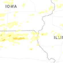
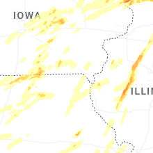
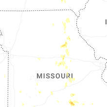
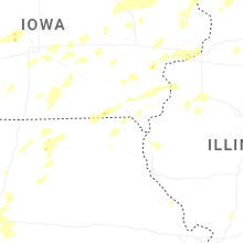


Connect with Interactive Hail Maps