Call Us Today! (512) 994-2550|[email protected]
Free Hail Map Reports

About mikeh

This author has not yet filled in any details.
So far mikeh has created 17 blog entries.

Hail Map Phoenix, AZ October 5, 2010

Hail Map Phoenix, AZ October 5, 2010


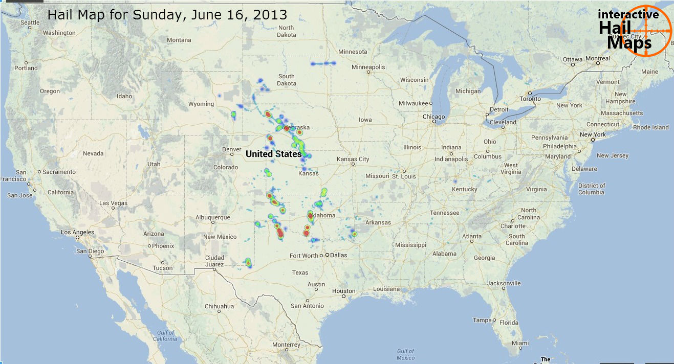
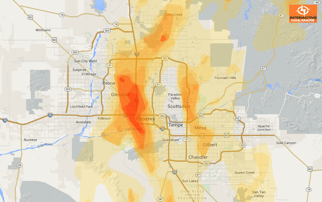
Here is a map of the hail storm that devastated the Phoenix area on October 5, 2010. A huge area was hit by two main storms traveling from south to north. One from Gilbert, AZ north to Scottsdale. The other from south of I-10 north through Phoenix all the […]

By |February 2nd, 2015|Categories: Historical Hail Maps|

Hail Map Oklahoma City, Oklahoma April 26, 2013


Hail Map Oklahoma City, Oklahoma April 26, 2013


This map shows the hail that moved through Oklahoma City, Oklahoma on April 26th, 2013.(Click on the map for a larger view)  This is the first of 3 separate hail storms that hit in and around Oklahoma City in 2013. The hail swaths are radar indicated with the […]

By |May 20th, 2014|Categories: Hail Maps, Historical Hail Maps|

US Severe Hail 2012 VS. 2013

Clearly, 2012 was a much better hail season for hail restoration professionals when compared to 2013.  We put all severe hail, 1.25 ” and larger, on comparison maps to give you a clear picture of just how slow the 2013 hail season really was. (click on the map for a larger view)  According to this […]

By |November 23rd, 2013|Categories: Hail News|

Hail Map Austin – San Marcos, Texas April 20, 2006

This historical hail map shows the hail storms that moved through central Texas on April 20th 2006.(Click on the map for a larger view) The most intense large hail is displayed with a heatmap. Around 5:00 pm a major hail storm hit the outlet malls in San Marcos, TX destroying cars and windshields. […]

By |June 30th, 2013|Categories: Historical Hail Maps|

Hail Map Fort Scott, Kansas April 7, 2013

Hail Map Fort Scott, Kansas April 7, 2013


This map shows the hail that moved through Fort Scott, Kansas on April 7th, 2013.(Click on the map for a larger view)  This hail storm moved over 100 miles from just outside Wichita to ultimately hit Fort Scott. Use Interactive Hail Maps to zoom all the way to […]

By |June 29th, 2013|Categories: Hail Maps, Historical Hail Maps|

Hail Map for Sunday, June 16, 2013

Here is a nationwide view of the hail that fell on Sunday, June 16th, 2013. (Click on the map for a larger view) This is radar indicated hail with the largest hail displayed with “heat” so you can quickly see the hardest hit areas. Large hail fell in the middle of the country on Sunday, […]

By |June 17th, 2013|Categories: Hail Reports|

Hail Map New Orleans, Louisiana February 24, 2013

Hail Map New Orleans, Louisiana February 24, 2013


This map shows the hail that hit the West Bank in the New Orleans area on February 24, 2013.  This is a huge hail storm many miles wide and many miles long. Thousands of roofs and vehicles were damaged. Use Interactive Hail Maps to zoom in and pinpoint […]

By |March 30th, 2013|Categories: Hail Maps, Historical Hail Maps|

Hail Storm Map For Columbia, Missouri, September 7, 2012

Hail Storm Map For Columbia, Missouri, September 7, 2012


Here is the hail map for the hail storm that hit Columbia, Missouri on September 7, 2012. The largest and most intense hail hit just to the west of the city.  Use Interactive Hail Maps to pinpoint hail damage.  Zero in to see the neighborhoods hit.

By |January 1st, 2013|Categories: Hail Maps, Historical Hail Maps|

Hail Storm Map Rocky Ford and La Junta Colorado September 27, 2012

Hail Storm Map Rocky Ford and La Junta Colorado September 27, 2012


This map shows the hail that came down the highway, hitting both Rocky Ford and La Junta Colorado on September 27, 2012.   Use Interactive Hail Maps to zoom in and pinpoint the exact neighborhoods affected.  Find the hail storms others are missing.  Subscribe to […]

By |December 12th, 2012|Categories: Hail Maps, Historical Hail Maps|

Hail Map for San Antonio, TX February 3, 2012

Hail Map for San Antonio, TX February 3, 2012


This map shows the hail that hit San Antonio on February 3, 2012.  Use Interactive Hail Maps to zoom in and pinpoint the exact neighborhoods affected.  Find the hail storms others are missing.  Subscribe to Interactive Hail Maps to receive Unlimited Full Screen Hail Maps, nationwide.

By |December 5th, 2012|Categories: Hail Maps, Historical Hail Maps|

Hail Map for Indianapolis, IN September 21, 2012

Hail Map for Indianapolis, IN September 21, 2012


Here is a map for a hail storm that hit Indianapolis, IN on September 21, 2012.  The green markers are on the ground hail reports up to 1.25 inch in diameter.  The blue markers are 1.5 and 1.75 inch on the ground reports.  Use Interactive Hail Maps to […]

By |November 27th, 2012|Categories: Hail Maps, Historical Hail Maps|

Hail Map for Milwaukee, WI September 17, 2012

Hail Map for Milwaukee, WI September 17, 2012


Here is a map for the hail that hit in and around Milwaukee, WI on September 17, 2012.   Use Interactive Hail Maps to find hail storms others are missing.  Zero in to the street level to see the exact neighborhoods hit.  Use Interactive Hail Maps to receive Unlimited […]

By |September 18th, 2012|Categories: Hail Maps, Historical Hail Maps|

Hail Map for Plano, TX August 17, 2012

Hail Map for Plano, TX August 17, 2012


Here is the hail map of the hail storm that hit Plano, TX on August 17, 2012.  Plano is heavily populated with damage to vehicles reported.  Use Interactive Hail Maps to pinpoint hail storms nationwide.  Scroll day to day and zoom all the way to street view to […]

By |September 15th, 2012|Categories: Hail Maps, Historical Hail Maps|

Hail Map for Morris, MN August 15, 2012

Hail Map for Morris, MN August 15, 2012


Here is a map for a hail storm that hit Morris, Minnesota on August 15, 2012.  The Blue Marker is a 1.75″ spotter hail report.  Use Interactive Hail Maps to pinpoint hail locations live and zoom all the way to street view.   Find the smaller hail storms […]

By |September 14th, 2012|Categories: Hail Maps, Historical Hail Maps|

Hail Map for Danville, IN August 9, 2012

Hail Map for Danville, IN August 9, 2012


Here is a heat map for a hail storm that hit just outside of Indianapolis on August 9, 2012.  The most intense hail hit just east of Danville.  Use Interactive Hail Maps to pinpoint hail locations live and zoom all the way to street view.   Find the […]

By |September 8th, 2012|Categories: Hail Maps, Historical Hail Maps|