

Hail Map for Friday, August 12, 2022

Number of Impacted Households on 8/12/2022
0
Impacted by 1" or Larger Hail
0
Impacted by 1.75" or Larger Hail
0
Impacted by 2.5" or Larger Hail
Square Miles of Populated Area Impacted on 8/12/2022
0
Impacted by 1" or Larger Hail
0
Impacted by 1.75" or Larger Hail
0
Impacted by 2.5" or Larger Hail

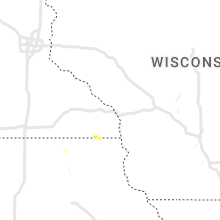


Cities Most Affected by Hail Storms of 8/12/2022
| Hail Size | Demographics of Zip Codes Affected | ||||||
|---|---|---|---|---|---|---|---|
| City | Count | Average | Largest | Pop Density | House Value | Income | Age |
| Yellow Pine, ID | 1 | 1.75 | 1.75 | 0 | $85k | $13.5k | 62.7 |
Hail and Wind Damage Spotted on 8/12/2022
Filter by Report Type:Hail ReportsWind Reports
States Impacted
Georgia, Washington, South Carolina, Arizona, Idaho, Oregon, Texas, North Carolina, MontanaGeorgia
| Local Time | Report Details |
|---|---|
| 8:13 AM EDT | Tree down along asbestos road near helen highwa in white county GA, 66.9 miles WSW of Greenville, SC |
Washington
| Local Time | Report Details |
|---|---|
| 8:30 AM PDT | Ping Pong Ball sized hail reported near Rosalia, WA, 23.4 miles S of Spokane, WA, picture report from facebook. |
| 9:09 AM PDT | Ping Pong Ball sized hail reported near Lind, WA, 63.5 miles NNW of Walla Walla, WA, twitter report. |
| 9:15 AM PDT | Quarter sized hail reported near Lind, WA, 66 miles N of Walla Walla, WA |
South Carolina
| Local Time | Report Details |
|---|---|
| 2:44 PM EDT | The south carolina highway patrol reported a tree down due to thunderstorm outflow near the intersection of buelah road and lodge highwa in colleton county SC, 47.4 miles W of Charleston, SC |
| 4:24 PM EDT | The south carolina highway patrol reported a tree down due to thunderstorm outflow near the intersection of mewville road and combahee roa in colleton county SC, 51.1 miles NNE of Savannah, GA |
| 6:00 PM EDT | Emergency management reported powerlines and trees down near innsbruck ct and boulder r in york county SC, 17.8 miles WSW of Charlotte, NC |
| 6:45 PM EDT | 911 call center reported power lines and trees down in multiple areas... especially around tom hall s in york county SC, 16.7 miles SSW of Charlotte, NC |
Arizona
| Local Time | Report Details |
|---|---|
| 12:00 PM MST | Quarter sized hail reported near Humboldt, AZ, 58.3 miles SW of Flagstaff, AZ, severe thunderstorm produced 1 inch hail... heavy rain... and gusty winds peaking at roughly 25 kts. |
| 2:45 PM MST | Power lines down in are in maricopa county AZ, 25.7 miles ESE of Phoenix, AZ |
| 3:05 PM MST | Corrects previous tstm wnd dmg report from 6 n east mesa. power lines down in are in maricopa county AZ, 23.8 miles E of Phoenix, AZ |
| 3:22 PM MST | Power lines down in are in maricopa county AZ, 13.6 miles E of Phoenix, AZ |
| 3:37 PM MST | Measured at ksdl... scottsdale municipal airpor in maricopa county AZ, 14.9 miles NE of Phoenix, AZ |
| 3:40 PM MST | Quarter sized hail reported near Scottsdale, AZ, 12.3 miles NE of Phoenix, AZ, quarter size hail... timing estimated from radar. |
| 4:00 PM MST | Metal power poles blown over trapping 18 vehicle in maricopa county AZ, 13.4 miles NE of Phoenix, AZ |
| 4:40 PM MST | Power line(s) dow in maricopa county AZ, 62.8 miles W of Phoenix, AZ |
Idaho
| Local Time | Report Details |
|---|---|
| 12:52 PM PDT | Strong thunderstorm winds estimated near 60 mph. half inch hail also fell with the stor in lewis county ID, 27.5 miles NW of Grangeville, ID |
| 2:39 PM MDT | Ping Pong Ball sized hail reported near Council, ID, 64.2 miles SSW of Grangeville, ID, hail ranging from quarter to ping pong. via social media. |
| 3:20 PM MDT | Half Dollar sized hail reported near Riggins, ID, 36.2 miles SSW of Grangeville, ID, hail between quarter and half dollar size reported from salmon rapids lodge. lots of leaves down but no other observed damage at this time. |
| 2:24 PM PDT | Tree was reportedly down near mile markers 143 and 144 on us-1 in idaho county ID, 56 miles WSW of Missoula, MT |
| 4:00 PM MDT | Quarter sized hail reported near , , 9.7 miles E of Boise, ID, via social media. time is approximate. |
| 4:10 PM MDT | 1" diameter tree limbs down. winds estimated to be 50-60 mph. nickel hai in owyhee county ID, 38.5 miles S of Boise, ID |
| 5:00 PM MDT | Golf Ball sized hail reported near Yellow Pine, ID, 73.4 miles SSE of Grangeville, ID, spotter reported isolated golf ball size hail dropping out of passing thunderstorm. |
Oregon
| Local Time | Report Details |
|---|---|
| 1:20 PM PDT | Ping Pong Ball sized hail reported near Oxbow, OR, 75.2 miles SSW of Grangeville, ID, via social media. time estimated from radar. |
Texas
| Local Time | Report Details |
|---|---|
| 3:30 PM CDT | Estimated wind 50 mph. metal roofs pulled back and some siding ripped off dilapidated buildings. minor damage to scalfolding and cinder block walls under construction a in hidalgo county TX, 35.1 miles WNW of Brownsville, TX |
North Carolina
| Local Time | Report Details |
|---|---|
| 4:37 PM EDT | Multiple reports of trees and power lines down in the city of conove in catawba county NC, 39.9 miles NNW of Charlotte, NC |
| 4:48 PM EDT | Powerlines down across roadway in the city of newto in catawba county NC, 37.1 miles NW of Charlotte, NC |
| 5:05 PM EDT | Tree blocking roadway in the city of maide in catawba county NC, 31.7 miles NW of Charlotte, NC |
| 5:05 PM EDT | Trees and power lines down in town of stanle in lincoln county NC, 18.5 miles NW of Charlotte, NC |
| 5:15 PM EDT | Tree down across roadway in city of lincolnto in lincoln county NC, 26.9 miles NW of Charlotte, NC |
| 5:17 PM EDT | Tree down across roadway in the town of val in lincoln county NC, 38.5 miles NW of Charlotte, NC |
| 5:34 PM EDT | Tree down on roadway in town of stanle in lincoln county NC, 17.4 miles NW of Charlotte, NC |
| 5:52 PM EDT | 911 call center reported multiple trees and power lines down throughout the city of mount holl in gaston county NC, 11.6 miles WNW of Charlotte, NC |
| 6:07 PM EDT | Report of trees down near the vineyards on lake wylie near the charlotte international airpor in mecklenburg county NC, 9.2 miles W of Charlotte, NC |
| 6:09 PM EDT | Corrects previous tstm wnd gst report from kclt. asos station kclt charlotte international airpor in mecklenburg county NC, 5.8 miles W of Charlotte, NC |
Montana
| Local Time | Report Details |
|---|---|
| 6:20 PM MDT | Mesonet station mtsbn sieben flats - md in lewis and clark county MT, 57 miles SW of Great Falls, MT |
| 6:37 PM MDT | Ambient sensor measured a 59 mph gus in teton county MT, 43.4 miles W of Great Falls, MT |
| 7:15 PM MDT | Reported via facebook. tree limb knocked down west of the town of vaughn. 6 to 8 inch diameter limb... estimated from imag in cascade county MT, 19.6 miles WNW of Great Falls, MT |
| 7:15 PM MDT | Mesonet station mtm76 cascade e md in cascade county MT, 21.5 miles SW of Great Falls, MT |
| 7:30 PM MDT | Mesonet station fw1664 hingha in hill county MT, 40.5 miles WNW of Havre, MT |
| 7:30 PM MDT | Estimated a minimum wind gust of 70 mph. time was approximated by spotte in cascade county MT, 13 miles W of Great Falls, MT |
| 7:33 PM MDT | An ambient weather station measured a 70 mph gus in hill county MT, 42.6 miles NW of Havre, MT |
Connect with Interactive Hail Maps