

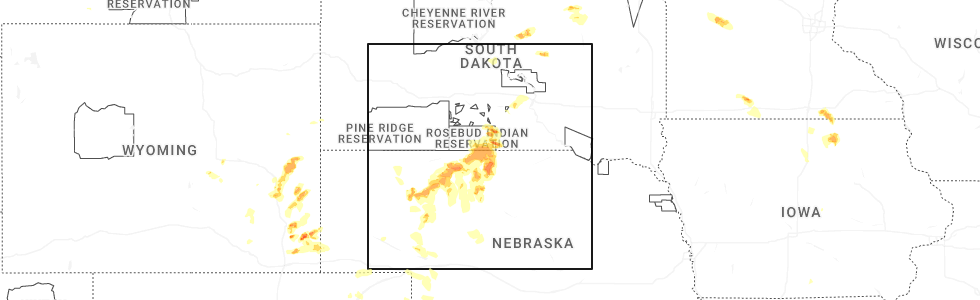
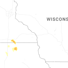
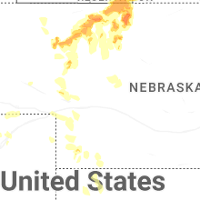
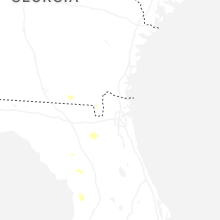
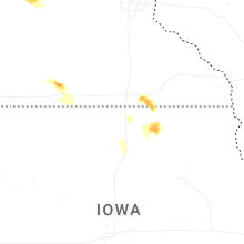
Hail Map for Thursday, June 12, 2025
Number of Impacted Households on 6/12/2025
0
Impacted by 1" or Larger Hail
0
Impacted by 1.75" or Larger Hail
0
Impacted by 2.5" or Larger Hail
Square Miles of Populated Area Impacted on 6/12/2025
0
Impacted by 1" or Larger Hail
0
Impacted by 1.75" or Larger Hail
0
Impacted by 2.5" or Larger Hail


Cities Most Affected by Hail Storms of 6/12/2025
| Hail Size | Demographics of Zip Codes Affected | ||||||
|---|---|---|---|---|---|---|---|
| City | Count | Average | Largest | Pop Density | House Value | Income | Age |
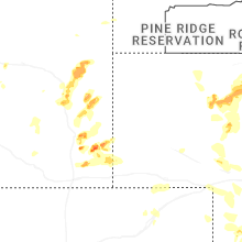
| Broadus, MT | 1 | 1.75 | 1.75 | 0 | $58k | $27.8k | 49.9 |
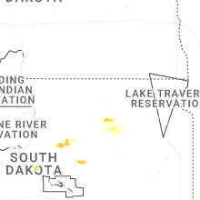
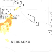
| Winner, SD | 1 | 1.75 | 1.75 | 4 | $55k | $29.0k | 45.4 |
| Valentine, NE | 1 | 1.75 | 1.75 | 3 | $68k | $29.9k | 44.3 |
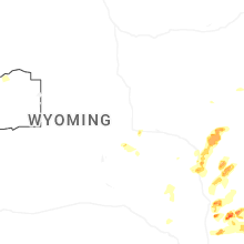
| Glendo, WY | 1 | 1.75 | 1.75 | 0 | $80k | $23.0k | 52.4 |
Hail and Wind Damage Spotted on 6/12/2025
Filter by Report Type:Hail ReportsWind Reports
States Impacted
Louisiana, Wyoming, South Dakota, Texas, North Carolina, Nebraska, Minnesota, South Carolina, New Mexico, Tennessee, Montana, Idaho, IowaLouisiana
| Local Time | Report Details |
|---|---|
| 1:49 PM CDT | Broadcast media reports pictures of snapped trees at womens hospital in baton rouge. time estimated by rada in east baton rouge county LA, 59.6 miles ENE of Lafayette, LA |
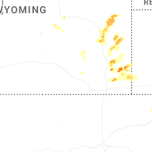
Wyoming
| Local Time | Report Details |
|---|---|
| 1:40 PM MDT | Mesonet station pc229 little bitter cree in sweetwater county WY, 15.8 miles S of Rock Springs, WY |
| 2:35 PM MDT | Ping Pong Ball sized hail reported near Meriden, WY, 34.3 miles SW of Scottsbluff, NE, storm chaser submitted mping of 1.5in hail on the ground from the first storm. hail time estimated via radar. |
| 3:03 PM MDT | Ping Pong Ball sized hail reported near Lagrange, WY, 35.4 miles WSW of Scottsbluff, NE, nws emloyees reported being impacted by 1.5in hail on their way back to the office. lost wiper blade due to hail. |
| 3:56 PM MDT | Half Dollar sized hail reported near Chugwater, WY, 53.5 miles W of Scottsbluff, NE, mping report of 1.25in hail. changed time on reprot due to report being delayed until after the storm left the area. |
| 4:06 PM MDT | Quarter sized hail reported near Chugwater, WY, 48.4 miles W of Scottsbluff, NE, trained spotter reported quarter sized hail. this report was delayed. time estimated via radar. |
| 4:12 PM MDT | Mping from storm chaser of measured 64mph wind gust with handheld kestre in goshen county WY, 25.7 miles W of Scottsbluff, NE |
| 4:14 PM MDT | Trained spotter estimated 60mph winds in albi in laramie county WY, 38 miles SW of Scottsbluff, NE |
| 4:59 PM MDT | Quarter sized hail reported near Wheatland, WY, 56 miles WNW of Scottsbluff, NE, trained spotter reported nickel to quarter sized hail. |
| 5:07 PM MDT | Quarter sized hail reported near Wheatland, WY, 56 miles WNW of Scottsbluff, NE, trained spotter reports quarter sized hail ongoing. |
| 5:08 PM MDT | Quarter sized hail reported near Fort Laramie, WY, 50.2 miles WNW of Scottsbluff, NE, emergency manager reports quarter sized hail ongoing in ft. laramie. |
| 5:15 PM MDT | Quarter sized hail reported near Fort Laramie, WY, 47.8 miles WNW of Scottsbluff, NE, emergency manager reports quarter sized hail at rd 15 and rd 70. |
| 5:19 PM MDT | Ping Pong Ball sized hail reported near Fort Laramie, WY, 50.2 miles WNW of Scottsbluff, NE, emergency manager shared photo via slack of hail bigger than a half dollar. |
| 6:06 PM MDT | Wydot sensor at coleman reported a 61mph wind gus in platte county WY, 74.8 miles ESE of Casper, WY |
| 6:42 PM MDT | Quarter sized hail reported near Glendo, WY, 72.5 miles ESE of Casper, WY, fire fighter reported quarter sized hail while fighting a lightning fire near glendo. |
| 6:47 PM MDT | Golf Ball sized hail reported near Glendo, WY, 75.2 miles ESE of Casper, WY, facebook report of golf ball sized hail east of glendo. |
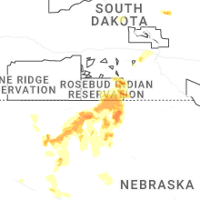
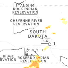
South Dakota
| Local Time | Report Details |
|---|---|
| 3:30 PM CDT | Ping Pong Ball sized hail reported near Okreek, SD, 35.1 miles NNE of Valentine, NE |
| 4:29 PM CDT | Quarter sized hail reported near Winner, SD, 21.7 miles NE of Valentine, NE |
| 4:50 PM CDT | Ping Pong Ball sized hail reported near Winner, SD, 28.3 miles NNE of Valentine, NE |
| 5:15 PM CDT | Quarter sized hail reported near Mission, SD, 16.6 miles N of Valentine, NE |
| 5:30 PM CDT | Golf Ball sized hail reported near Winner, SD, 17.6 miles NNE of Valentine, NE |
| 5:50 PM CDT | Storm damage reported in todd county SD, 11.5 miles NNW of Valentine, NE |
Texas
| Local Time | Report Details |
|---|---|
| 3:43 PM CDT | Corrects previous time from previous tstm wnd dmg report from corpus christi. large 30 ft tree down at intersection of leonard and mayfield s in nueces county TX, 11.8 miles WNW of Corpus Christi, TX |
| 4:30 PM CDT | Power pole blown down blocking the roadway at oso bridg in gmz232 county TX, 11.5 miles SSE of Corpus Christi, TX |
| 4:30 PM CDT | Nas corpus christi aso in nueces county TX, 10.1 miles SE of Corpus Christi, TX |
| 4:42 PM CDT | Peak gust of 52 kts at buoy in baffin bay (babt2 in gmz231 county TX, 34.2 miles S of Corpus Christi, TX |
| 4:43 PM CDT | Large 30 ft tree down at intersection of leonard and mayfield s in nueces county TX, 11.8 miles WNW of Corpus Christi, TX |
| 4:50 PM CDT | A fence was blown down on the island just northeast of the francine cohn preserv in nueces county TX, 17.5 miles E of Corpus Christi, TX |
| 7:55 PM CDT | Awos station ktxw weslaco midvall in hidalgo county TX, 35.3 miles WNW of Brownsville, TX |
| 8:04 PM CDT | Weslaco emergency management reported a residence trailer was rolled during strong winds just north of the expressway near mile 10 and mile 4 1/2 west with no injurie in hidalgo county TX, 36 miles NW of Brownsville, TX |
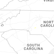
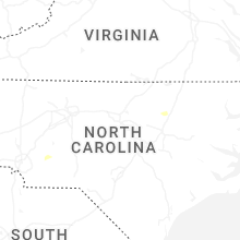
North Carolina
| Local Time | Report Details |
|---|---|
| 5:34 PM EDT | Several trees down on the west side of the city of albemarle in the judy street and burleson street areas... including some that fell onto homes. no injurie in stanly county NC, 35.7 miles ENE of Charlotte, NC |
| 10:30 PM EDT | Several trees are down and blocking cook school road in pilot mountain. a power line is also down in an adjacent field with the transformer on fire. time is estimated f in surry county NC, 65.8 miles SSW of Roanoke, VA |
Nebraska
| Local Time | Report Details |
|---|---|
| 4:12 PM MDT | Mping from storm chaser of 64mph wind gust measured with handheld kestre in banner county NE, 32 miles SSW of Scottsbluff, NE |
| 6:05 PM CDT | Quarter sized hail reported near Valentine, NE, 4.6 miles N of Valentine, NE |
| 6:13 PM CDT | Storm damage reported in cherry county NE, 1 miles S of Valentine, NE |
| 6:20 PM CDT | Golf Ball sized hail reported near Valentine, NE, 0.4 miles N of Valentine, NE |
| 6:21 PM CDT | Half Dollar sized hail reported near Valentine, NE, 0.4 miles N of Valentine, NE |
| 7:01 PM CDT | Ping Pong Ball sized hail reported near Wood Lake, NE, 16 miles ESE of Valentine, NE |
| 6:48 PM MDT | Ping Pong Ball sized hail reported near Nenzel, NE, 40.3 miles WSW of Valentine, NE |
| 11:43 PM CDT | Asos station kmck mccook airport measures 58 mph wind gust with storm in red willow county NE, 60.7 miles NNE of Colby, KS |
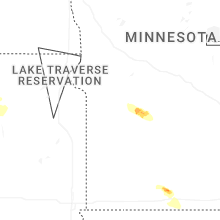
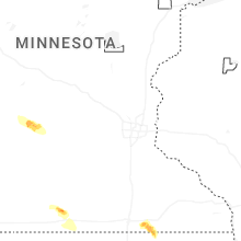
Minnesota
| Local Time | Report Details |
|---|---|
| 5:21 PM CDT | Half Dollar sized hail reported near Butterfield, MN, 86.4 miles NNE of Storm Lake, IA |
| 6:35 PM CDT | Photos of fallen large trees and tree limb in mower county MN, 33.2 miles NNE of Mason City, IA |
| 7:06 PM CDT | Ping Pong Ball sized hail reported near Austin, MN, 37.3 miles NNE of Mason City, IA |
| 7:07 PM CDT | Ping Pong Ball sized hail reported near Austin, MN, 33.1 miles NNE of Mason City, IA |
| 7:13 PM CDT | Numerous large trees and power lines down across hutchinso in mcleod county MN, 54.6 miles W of Minneapolis, MN |
| 7:15 PM CDT | Awos station khcd hutchinson a in mcleod county MN, 55.2 miles W of Minneapolis, MN |
| 7:18 PM CDT | Quarter sized hail reported near Lyle, MN, 28.8 miles NNE of Mason City, IA |
South Carolina
| Local Time | Report Details |
|---|---|
| 6:50 PM EDT | Rc winds site recorded a 59 mph wind gust on the north shore of lake murra in richland county SC, 59.5 miles NE of Augusta, GA |
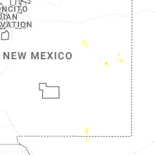
New Mexico
| Local Time | Report Details |
|---|---|
| 4:51 PM MDT | Storm damage reported in eddy county NM, 84.4 miles S of Roswell, NM |
| 6:45 PM MDT | Em reported structure damage at granada shopping mall. one store had the front wall pushed in and roof collapsed and another business had its roof lifted up and then sl in otero county NM, 84 miles NNE of El Paso, TX |
Tennessee
| Local Time | Report Details |
|---|---|
| 5:55 PM CDT | Many trees were blown down in the cedar grove are in carroll county TN, 22 miles SSW of Mc Kenzie, TN |
| 6:30 PM CDT | Tree down on power lines... hwy 70 near cedar grove and nickel size hai in carroll county TN, 22 miles SSW of Mc Kenzie, TN |
Montana
| Local Time | Report Details |
|---|---|
| 5:35 PM MDT | Quarter sized hail reported near Volborg, MT, 53.8 miles S of Miles City, MT |
| 5:50 PM MDT | Golf Ball sized hail reported near Broadus, MT, 63.5 miles SSE of Miles City, MT, time estimated from radar. |
| 5:50 PM MDT | Roof blown off house. tree uprooted. time estimated from rada in powder river county MT, 63.5 miles SSE of Miles City, MT |
| 5:55 PM MDT | Quarter sized hail reported near Olive, MT, 61 miles SSE of Miles City, MT |
Idaho
| Local Time | Report Details |
|---|---|
| 5:45 PM MDT | Mesonet station ato atomic cit in bingham county ID, 38.8 miles W of Idaho Falls, ID |
| 6:00 PM MDT | Mesonet station ebr inl materials fuels comple in bingham county ID, 31.3 miles WNW of Idaho Falls, ID |
Iowa
| Local Time | Report Details |
|---|---|
| 7:30 PM CDT | A third of a large willow tree blown dow in floyd county IA, 23.3 miles E of Mason City, IA |
| 8:36 PM CDT | Photo of fallen large tre in floyd county IA, 23.3 miles E of Mason City, IA |
Connect with Interactive Hail Maps