

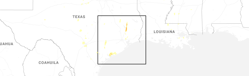
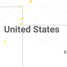
Hail Map for Wednesday, June 11, 2025
Number of Impacted Households on 6/11/2025
0
Impacted by 1" or Larger Hail
0
Impacted by 1.75" or Larger Hail
0
Impacted by 2.5" or Larger Hail
Square Miles of Populated Area Impacted on 6/11/2025
0
Impacted by 1" or Larger Hail
0
Impacted by 1.75" or Larger Hail
0
Impacted by 2.5" or Larger Hail

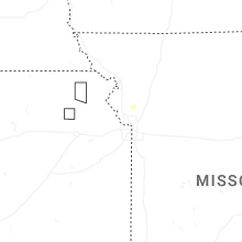
Cities Most Affected by Hail Storms of 6/11/2025
| Hail Size | Demographics of Zip Codes Affected | ||||||
|---|---|---|---|---|---|---|---|
| City | Count | Average | Largest | Pop Density | House Value | Income | Age |
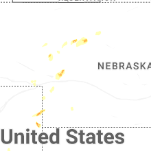
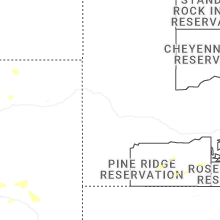
| Wray, CO | 1 | 1.75 | 1.75 | 5 | $72k | $33.4k | 39.1 |
Hail and Wind Damage Spotted on 6/11/2025
Filter by Report Type:Hail ReportsWind Reports
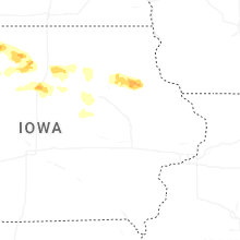
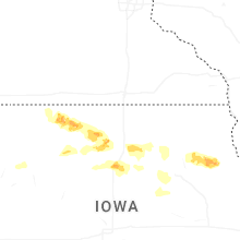
States Impacted
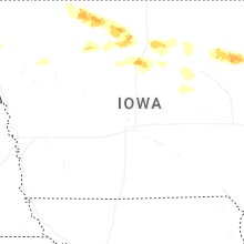
Iowa, Idaho, North Carolina, Florida, South Carolina, Louisiana, Wyoming, Montana, Colorado, New Mexico, TexasIowa
| Local Time | Report Details |
|---|---|
| 1:26 PM CDT | Trees reported down in rock rapids. time estimated from rada in lyon county IA, 29.3 miles ESE of Sioux Falls, SD |
| 1:31 PM CDT | Personal weather statio in lyon county IA, 31.4 miles ESE of Sioux Falls, SD |
| 1:31 PM CDT | Roof blown off hog barn. time estimated from rada in lyon county IA, 31.8 miles E of Sioux Falls, SD |
| 1:35 PM CDT | Personal weather statio in lyon county IA, 32.1 miles ESE of Sioux Falls, SD |
| 1:35 PM CDT | Machine shed and empty grain bin destroyed. semi truck tippe in lyon county IA, 36.5 miles ESE of Sioux Falls, SD |
| 1:45 PM CDT | Cattle barn significantly damaged. time estimated from rada in lyon county IA, 43.5 miles ESE of Sioux Falls, SD |
| 1:50 PM CDT | Trees are down from thunderstorm wind gusts. time estimated from rada in lyon county IA, 43.2 miles E of Sioux Falls, SD |
| 1:56 PM CDT | Trees reported down in sibley. time estimated from rada in osceola county IA, 50.8 miles E of Sioux Falls, SD |
| 1:56 PM CDT | Roof blown off shed. time estimated from rada in osceola county IA, 50.3 miles E of Sioux Falls, SD |
| 2:00 PM CDT | Mesonet station rsyi4 sibley. time estimated from rada in osceola county IA, 51.9 miles E of Sioux Falls, SD |
| 2:01 PM CDT | Lean-to damaged along hwy 9. time estimated from rada in osceola county IA, 53.9 miles E of Sioux Falls, SD |
| 2:03 PM CDT | 3/4 mile of power poles knocked down by thunderstorm wind gust in osceola county IA, 55.3 miles E of Sioux Falls, SD |
| 2:05 PM CDT | Personal weather statio in osceola county IA, 51.7 miles E of Sioux Falls, SD |
| 2:23 PM CDT | Estimated wind gust of 60 mph. a lot of blowing dus in osceola county IA, 55.6 miles NNW of Storm Lake, IA |
| 2:29 PM CDT | Personal weather station reported 60 mph gus in osceola county IA, 48.5 miles NNW of Storm Lake, IA |
| 2:43 PM CDT | Pea sized hail accompanied 58 mph thunderstorm wind gust in dickinson county IA, 52.2 miles N of Storm Lake, IA |
| 2:54 PM CDT | Quarter sized hail reported near Le Mars, IA, 55.6 miles SSE of Sioux Falls, SD, mostly dime to nickel sized hail... but some as big as a quarter. briefly heavy rainfall from the thundesrstorm. |
| 2:54 PM CDT | Tree damage in the vicinity of 190th avenue and 260th street. time estimated from rada in dickinson county IA, 43 miles N of Storm Lake, IA |
| 2:56 PM CDT | Two trees down along 280th stree in clay county IA, 40.9 miles N of Storm Lake, IA |
| 3:02 PM CDT | Large tree branch down from 50-60 mph thunderstorm wind gust. time estimated from rada in dickinson county IA, 47.2 miles N of Storm Lake, IA |
| 3:06 PM CDT | Mesonet station fw7399 terri in dickinson county IA, 46.1 miles NNE of Storm Lake, IA |
| 3:40 PM CDT | Strong wind gusts with large branches down in emmetsbur in palo alto county IA, 42 miles NE of Storm Lake, IA |
| 3:51 PM CDT | Measured by personal weather statio in palo alto county IA, 45.4 miles NE of Storm Lake, IA |
| 4:04 PM CDT | From personal weather statio in palo alto county IA, 45.6 miles NE of Storm Lake, IA |
| 4:18 PM CDT | From personal weather statio in kossuth county IA, 51.9 miles ENE of Storm Lake, IA |
| 4:27 PM CDT | Measured at algona airpor in kossuth county IA, 54.3 miles W of Mason City, IA |
| 4:29 PM CDT | Social media picture of medium to large tree branch sent through house roof. time estimated from rada in kossuth county IA, 51.7 miles W of Mason City, IA |
| 4:29 PM CDT | Multiple trees damaged with medium to large limbs down. one tree broken off at the base. one outbuilding damaged. time estimated from rada in kossuth county IA, 51.8 miles W of Mason City, IA |
| 5:03 PM CDT | Quarter sized hail reported near Corwith, IA, 39.6 miles WSW of Mason City, IA, quarter or a touch bigger hail east of corwith on 150th st. reported by corwith fire. |
| 5:17 PM CDT | Ping Pong Ball sized hail reported near Clarion, IA, 37.8 miles SW of Mason City, IA, ping pong size hail south of kanawha at 170th and jackson. |
| 5:20 PM CDT | Personal weather statio in wright county IA, 32.5 miles SW of Mason City, IA |
| 5:39 PM CDT | Corrects previous tstm wnd dmg report from belmond. small to large tree branches down in belmond. time estimated from rada in wright county IA, 29.1 miles SW of Mason City, IA |
| 5:39 PM CDT | Awos station kcav clarion airpor in wright county IA, 39.8 miles SW of Mason City, IA |
| 5:54 PM CDT | Delayed report. damage to an outbuilding on a farm near dows. images found via social medi in wright county IA, 44 miles SSW of Mason City, IA |
| 6:05 PM CDT | Iowa dot rwi in wright county IA, 41.9 miles SSW of Mason City, IA |
| 6:30 PM CDT | Personal weather statio in franklin county IA, 25.6 miles SSE of Mason City, IA |
| 6:47 PM CDT | Observed 60 mile an hour on anemomete in hardin county IA, 51.6 miles S of Mason City, IA |
| 7:08 PM CDT | Personal weather statio in grundy county IA, 57.9 miles WNW of Cedar Rapids, IA |
| 7:16 PM CDT | Personal weather statio in black hawk county IA, 42.5 miles NW of Cedar Rapids, IA |
| 7:27 PM CDT | Personal weather statio in black hawk county IA, 54.1 miles NW of Cedar Rapids, IA |
| 7:28 PM CDT | Tree damage covering road. small to medium branches. time estimated from rada in black hawk county IA, 49.5 miles NW of Cedar Rapids, IA |
| 7:28 PM CDT | Personal weather statio in black hawk county IA, 54.5 miles NW of Cedar Rapids, IA |
| 7:28 PM CDT | Various sized branches down across southern portions of of the city. time estimated by rada in fayette county IA, 49.4 miles NNW of Cedar Rapids, IA |
| 7:28 PM CDT | 60 mph winds in cedar fall in black hawk county IA, 54.7 miles NW of Cedar Rapids, IA |
| 7:30 PM CDT | Delayed report. multiple pictures of large tree branches (one over 18 inches) down in cedar falls. exact time and location estimate in black hawk county IA, 54 miles NW of Cedar Rapids, IA |
| 7:32 PM CDT | Personal weather statio in tama county IA, 49.8 miles WNW of Cedar Rapids, IA |
| 7:36 PM CDT | Quarter sized hail reported near Oelwein, IA, 50.1 miles NNW of Cedar Rapids, IA, dime to quarter sized hail covering the ground with strong winds. |
| 7:36 PM CDT | Tree on power lines. power out in portions of cedar fall in black hawk county IA, 53.5 miles NW of Cedar Rapids, IA |
| 7:37 PM CDT | Multiple homes damaged by downed tree limbs. time estimated from rada in black hawk county IA, 49.1 miles NW of Cedar Rapids, IA |
| 7:45 PM CDT | 50 mph winds with 63 mph gusts. 5 mi n of dysar in tama county IA, 37.4 miles WNW of Cedar Rapids, IA |
| 7:48 PM CDT | Delayed report. semi blown over on highway 20 east of waterloo. time and location estimate in black hawk county IA, 42.7 miles NW of Cedar Rapids, IA |
| 7:50 PM CDT | 60 mph winds and heavy rain in traer are in tama county IA, 43 miles WNW of Cedar Rapids, IA |
| 7:52 PM CDT | Personal weather statio in black hawk county IA, 35.2 miles NW of Cedar Rapids, IA |
| 7:53 PM CDT | Corrects previous tstm wnd dmg report from 2 se raymond. delayed report. semi blown over on highway 20 east of waterloo/southwest of jesup. time estimated from rada in black hawk county IA, 39.6 miles NW of Cedar Rapids, IA |
| 8:12 PM CDT | Likely with outflow ahead of the storm in buchanan county IA, 29.6 miles N of Cedar Rapids, IA |
| 8:15 PM CDT | Large tree in roadway at 245th st and 260th ave east of delhi. done by storm outflow winds well ahead of the storms themselves. time estimated by outflow signature on r in delaware county IA, 37 miles NNE of Cedar Rapids, IA |
| 8:15 PM CDT | A lot of tree litter being blown around at time of maximum gust in benton county IA, 26.6 miles NW of Cedar Rapids, IA |
| 8:15 PM CDT | Awos station kvti vinton arp in benton county IA, 24.5 miles NW of Cedar Rapids, IA |
| 8:29 PM CDT | Large lighting pole downed at baseball field at fairground in delaware county IA, 37.9 miles NNE of Cedar Rapids, IA |
| 8:29 PM CDT | Large lighting pole downed at baseball field at fairgrounds. with outflow wind gusts well ahead of storm in delaware county IA, 37.9 miles NNE of Cedar Rapids, IA |
| 8:33 PM CDT | Estimated 60 mph gust blew over lawn furnitur in benton county IA, 27.1 miles W of Cedar Rapids, IA |
| 8:35 PM CDT | Relayed by kcrg tv station. time estimated using rada in benton county IA, 19.9 miles NNW of Cedar Rapids, IA |
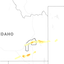
Idaho
| Local Time | Report Details |
|---|---|
| 12:30 PM MDT | Stanley raw in custer county ID, 73.7 miles ENE of Boise, ID |
| 2:10 PM MDT | Power outage in portions of butte count in butte county ID, 58.9 miles W of Idaho Falls, ID |
| 2:15 PM MDT | Half Dollar sized hail reported near Pocatello, ID, 48.8 miles SW of Idaho Falls, ID, observed at wfo pocatello. |
| 3:00 PM MDT | Itd mesone in custer county ID, 68 miles SSW of Salmon, ID |
| 3:30 PM MDT | Station canyon pacficorp mesonet on malad summi in oneida county ID, 82.3 miles S of Idaho Falls, ID |
| 3:45 PM MDT | Fish creek summit itd mesone in caribou county ID, 60.6 miles S of Idaho Falls, ID |
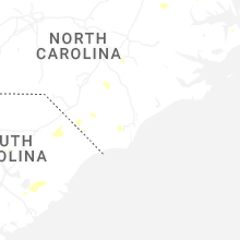
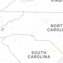
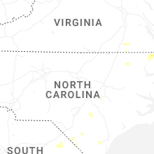
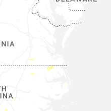
North Carolina
| Local Time | Report Details |
|---|---|
| 2:33 PM EDT | Quarter sized hail reported near Sunbury, NC, 37.5 miles SW of Virginia Beach, VA, the 911 call center reported hail in sunbury. |
| 5:49 PM EDT | Large number of power outages due to fallen tree in sampson county NC, 57.2 miles NNW of Wilmington, NC |
| 6:10 PM EDT | Tree dow in sampson county NC, 55.3 miles NNW of Wilmington, NC |
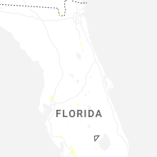
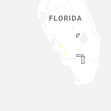
Florida
| Local Time | Report Details |
|---|---|
| 3:25 PM EDT | Caller reported large oak tree branches down on his property near the intersection of west river rd and cheffey r in putnam county FL, 42.3 miles S of Jacksonville, FL |
| 5:00 PM EDT | Quarter sized hail reported near Fort Myers, FL, 36.8 miles N of Naples, FL, quarter size hail reported in buckingham... fl. |
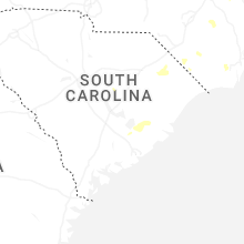
South Carolina
| Local Time | Report Details |
|---|---|
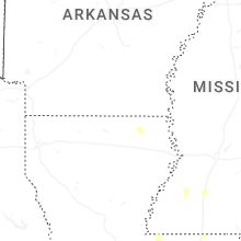
| 4:03 PM EDT | Trained spotter reported significant crop damage to a corn field with a photo of all stalks crushed to the ground from a downburst. also pea sized hail occurred. time e in aiken county SC, 33 miles ENE of Augusta, GA |
| 4:17 PM EDT | Reports of four trees down in and near the city of mario in marion county SC, 76.4 miles NNE of Charleston, SC |
| 4:28 PM EDT | Photo shared on social media of a tree down across calder road between marion and mullins in marion county SC, 79.3 miles W of Wilmington, NC |
| 5:40 PM EDT | Ping Pong Ball sized hail reported near Moncks Corner, SC, 4.8 miles SW of Charleston, SC, ping pong ball size hail reported on oakley rd in whitesville. |
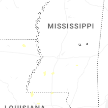
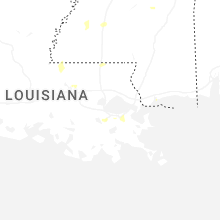
Louisiana
| Local Time | Report Details |
|---|---|
| 4:22 PM CDT | Reports of several trees and powerlines down across the parish. especially in colfax and montgomer in grant county LA, 92.1 miles SE of Shreveport, LA |
| 5:27 PM CDT | Quarter sized hail reported near Baker, LA, 61.2 miles ENE of Lafayette, LA, broadcast media relayed report of quarter sized hail on pheasantwood drive in central this afternoon. time estimated from radar. |
| 5:42 PM CDT | Several trees downed in and around the downsville communit in union county LA, 30.6 miles WSW of Bastrop, LA |
| 5:45 PM CDT | Central fire department responded to an uprooted tree from thunderstorm winds near the intersection of brown road and comite drive. report relayed by local broadcast me in east baton rouge county LA, 59 miles ENE of Lafayette, LA |
Wyoming
| Local Time | Report Details |
|---|---|
| 4:11 PM MDT | Quarter sized hail reported near Alpine, WY, 57.8 miles ESE of Idaho Falls, ID, dime to quarter sized hail found 10 to 15 minutes after storm passed. |
| 4:15 PM MDT | Quarter sized hail reported near Etna, WY, 59.3 miles ESE of Idaho Falls, ID, estimated quarter sized hail with very strong winds that bent trees. unable to leave building to investigate for damage. |
| 5:10 PM MDT | Quarter sized hail reported near Recluse, WY, 46.8 miles NNW of Gillette, WY |
| 5:20 PM MDT | Mesonet station pc452 cottonwood mern in sublette county WY, 98 miles W of Riverton, WY |
| 5:52 PM MDT | Ping Pong Ball sized hail reported near Recluse, WY, 40.3 miles N of Gillette, WY |
| 5:55 PM MDT | Awos station kpna pinedale airpor in sublette county WY, 73.6 miles WSW of Riverton, WY |
| 6:00 PM MDT | Mesonet station pc258 half moon lak in sublette county WY, 71.7 miles W of Riverton, WY |
| 6:27 PM MDT | Half Dollar sized hail reported near Gillette, WY, 22.9 miles NW of Gillette, WY |
| 6:52 PM MDT | Mesonet station khld hiland 2.4 se (wydot in natrona county WY, 52.9 miles WNW of Casper, WY |
| 8:46 PM MDT | Storm damage reported in campbell county WY, 48.6 miles SSW of Gillette, WY |
Montana
| Local Time | Report Details |
|---|---|
| 5:25 PM MDT | Mesonet station tt839 quad cree in carbon county MT, 68.2 miles SW of Billings, MT |
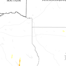
Colorado
| Local Time | Report Details |
|---|---|
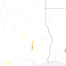
| 6:00 PM MDT | Golf Ball sized hail reported near Wray, CO, 30.5 miles ESE of Yuma, CO, estimated ping pong to golf ball size hail. |
| 6:14 PM MDT | Quarter sized hail reported near Wray, CO, 27.3 miles E of Yuma, CO, quarter sized hail reported on the east side of wray. |
| 6:20 PM MDT | Ping Pong Ball sized hail reported near Wray, CO, 26.3 miles E of Yuma, CO |
| 6:31 PM MDT | Ping Pong Ball sized hail reported near Wray, CO, 30.5 miles ESE of Yuma, CO |
| 6:32 PM MDT | Ping Pong Ball sized hail reported near Wray, CO, 26.3 miles E of Yuma, CO |
| 6:58 PM MDT | Mesonet station up711 7.7 nw boyero (upr in lincoln county CO, 82.8 miles SSW of Yuma, CO |
New Mexico
| Local Time | Report Details |
|---|---|
| 7:53 PM MDT | Asos station krtn raton crews airpor in colfax county NM, 63.6 miles ENE of Taos, NM |
Texas
| Local Time | Report Details |
|---|---|
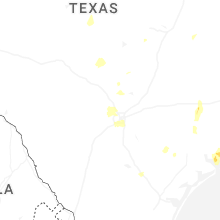
| 11:42 PM CDT | Estimated 60 mph wind gust and hail up to penny siz in bexar county TX, 15.8 miles NW of San Antonio, TX |
Connect with Interactive Hail Maps