

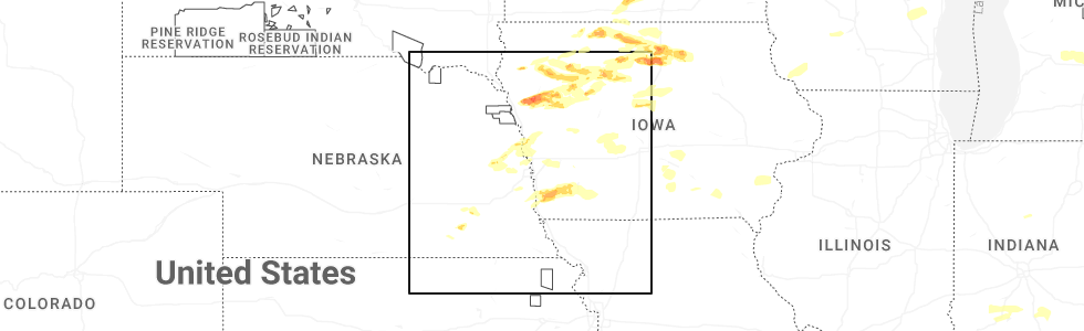
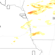
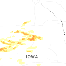
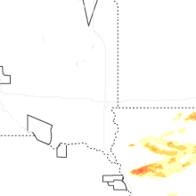
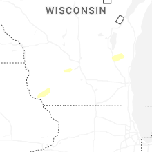
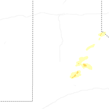
Hail Map for Friday, May 15, 2026
Number of Impacted Households on 5/15/2026
0
Impacted by 1" or Larger Hail
0
Impacted by 1.75" or Larger Hail
0
Impacted by 2.5" or Larger Hail
Square Miles of Populated Area Impacted on 5/15/2026
0
Impacted by 1" or Larger Hail
0
Impacted by 1.75" or Larger Hail
0
Impacted by 2.5" or Larger Hail
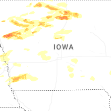
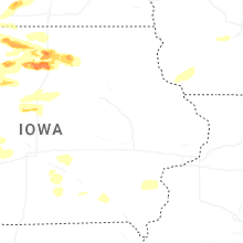
Cities Most Affected by Hail Storms of 5/15/2026
| Hail Size | Demographics of Zip Codes Affected | ||||||
|---|---|---|---|---|---|---|---|
| City | Count | Average | Largest | Pop Density | House Value | Income | Age |
| Kanawha, IA | 2 | 2.25 | 2.50 | 9 | $39k | $34.3k | 46.5 |
| Goodell, IA | 1 | 2.50 | 2.50 | 9 | $30k | $32.1k | 47.3 |
| Anthon, IA | 1 | 2.00 | 2.00 | 8 | $54k | $32.8k | 46.1 |
| Meservey, IA | 1 | 2.00 | 2.00 | 6 | $35k | $33.7k | 44.8 |
| Woden, IA | 1 | 2.00 | 2.00 | 5 | $38k | $30.3k | 42.6 |
| Thornton, IA | 1 | 1.75 | 1.75 | 8 | $49k | $35.9k | 45.0 |
| Bancroft, IA | 1 | 1.75 | 1.75 | 10 | $43k | $32.4k | 45.8 |
| Ringsted, IA | 1 | 1.75 | 1.75 | 7 | $31k | $27.9k | 46.8 |
Hail and Wind Damage Spotted on 5/15/2026
Filter by Report Type:Hail ReportsWind Reports
Texas
| Local Time | Report Details |
|---|---|
| 3:50 PM CDT | Storm damage reported in cochran county TX, 51.8 miles W of Lubbock, TX |
| 5:34 PM CDT | Storm damage reported in hockley county TX, 21.5 miles WNW of Lubbock, TX |
| 5:35 PM CDT | Awos ke57 denver city airpor in yoakum county TX, 70.9 miles SW of Lubbock, TX |
| 5:55 PM CDT | Also gusted to 60 mph at 556 p in hockley county TX, 18.1 miles W of Lubbock, TX |
| 6:00 PM CDT | Also gusted to 60 mph at 603 p in lubbock county TX, 11.3 miles W of Lubbock, TX |
| 6:00 PM CDT | Storm damage reported in floyd county TX, 56.3 miles NE of Lubbock, TX |
| 6:00 PM CDT | Mesonet station 15 seagraves 1sw measured an 84 mph wind gust from a convective downburs in gaines county TX, 61.1 miles SW of Lubbock, TX |
| 6:12 PM CDT | Asos klbb lubbock int. airport. also gusted to 64 mph at 609 p in lubbock county TX, 5.7 miles NNE of Lubbock, TX |
| 6:25 PM CDT | Asos klbb lubbock int. airport. also gusted to 66 mph at 624 p in lubbock county TX, 5.7 miles NNE of Lubbock, TX |
| 6:49 PM CDT | Storm damage reported in lynn county TX, 26.7 miles S of Lubbock, TX |
| 6:52 PM CDT | Also gusted to 59 mph at 651 p in lubbock county TX, 16.4 miles SE of Lubbock, TX |
| 6:54 PM CDT | Also gusted to 59 mph at 653 p in hale county TX, 20.6 miles NNE of Lubbock, TX |
| 6:58 PM CDT | Additional severe gusts ranging from 59 mph to 70 mph measured from 649 pm to 7 p in lynn county TX, 42.2 miles S of Lubbock, TX |
| 7:25 PM CDT | Additional gusts ranging from 59 to 62 mph measured from 723 pm to 724 p in garza county TX, 40.3 miles SSE of Lubbock, TX |
| 7:38 PM CDT | Also gusted to 58 mph at 737 p in cottle county TX, 38.7 miles SSW of Childress, TX |
| 7:39 PM CDT | Also gusted to 60 mph at 738 pm and again at 743 p in garza county TX, 39 miles SE of Lubbock, TX |
| 8:08 PM CDT | Storm damage reported in sherman county TX, 81.2 miles NNW of Amarillo, TX |
| 8:22 PM CDT | Storm damage reported in kent county TX, 72.2 miles NW of Abilene, TX |
| 8:48 PM CDT | Storm damage reported in cottle county TX, 36.8 miles S of Childress, TX |
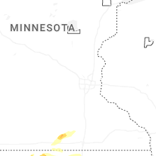
North Dakota
| Local Time | Report Details |
|---|---|
| 3:55 PM CDT | Awos station k1in 3 w palermo. gust associated with showers and weak thunderstorms in the are in mountrail county ND, 46.8 miles W of Minot, ND |
New Mexico
| Local Time | Report Details |
|---|---|
| 3:24 PM MDT | Recorded thunderstorm wind gust via west texas mesonet statio in lea county NM, 68.7 miles E of Roswell, NM |
| 3:44 PM MDT | Power outages reported in tatum associated with straight-line wind gust in lea county NM, 70.2 miles E of Roswell, NM |
| 4:30 PM MDT | Mesonet station clrn5 clayton lrc. microburst from a high based thunderstor in union county NM, 95.9 miles NNE of Tucumcari, NM |
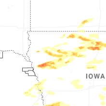
Iowa
| Local Time | Report Details |
|---|---|
| 5:20 PM CDT | Quarter sized hail reported near Terril, IA, 47.7 miles N of Storm Lake, IA |
| 5:24 PM CDT | Brief 60 mph wind gust... pea hail... and 0.05 inch rain before storm took off to the eas in dickinson county IA, 49.1 miles N of Storm Lake, IA |
| 5:59 PM CDT | Quarter sized hail reported near Ringsted, IA, 57.1 miles NE of Storm Lake, IA, nickel to quarter size hail. |
| 6:00 PM CDT | Quarter sized hail reported near Hornick, IA, 52.9 miles WSW of Storm Lake, IA, hail covered the ground... with stones as big as quarters. no wind and a decent amount of rain. |
| 6:03 PM CDT | Golf Ball sized hail reported near Ringsted, IA, 57.1 miles NE of Storm Lake, IA |
| 6:04 PM CDT | Quarter sized hail reported near Hornick, IA, 49.6 miles WSW of Storm Lake, IA |
| 6:09 PM CDT | Quarter sized hail reported near Armstrong, IA, 62.9 miles NE of Storm Lake, IA |
| 6:19 PM CDT | Quarter sized hail reported near Anthon, IA, 40.3 miles WSW of Storm Lake, IA |
| 6:20 PM CDT | Trees down in tabo in fremont county IA, 28.6 miles SSE of Omaha, NE |
| 6:22 PM CDT | Hen Egg sized hail reported near Anthon, IA, 38.5 miles WSW of Storm Lake, IA, 2 inch hail was reported via social media along with damage to lights fixtures and trees. |
| 6:23 PM CDT | Farm augers blown over and grain wagons move in mills county IA, 31.8 miles SE of Omaha, NE |
| 6:24 PM CDT | Golf Ball sized hail reported near Bancroft, IA, 52.4 miles WNW of Mason City, IA |
| 6:25 PM CDT | Small to medium tree down. time estimated by rada in kossuth county IA, 52.4 miles WNW of Mason City, IA |
| 6:32 PM CDT | Quarter sized hail reported near Correctionville, IA, 33.6 miles WSW of Storm Lake, IA |
| 6:37 PM CDT | Tress downed in imogen in fremont county IA, 37.4 miles SE of Omaha, NE |
| 6:40 PM CDT | Tree down at emerson cemeter in mills county IA, 32.7 miles ESE of Omaha, NE |
| 6:43 PM CDT | Quarter sized hail reported near Newell, IA, 10.8 miles ESE of Storm Lake, IA |
| 6:43 PM CDT | Quarter sized hail reported near Emerson, IA, 32.8 miles ESE of Omaha, NE, chaser live stream of one inch hail. location is approximate. |
| 6:54 PM CDT | Corrects previous tstm wnd dmg report from red oak. power was reported out in parts of red oak. power poles down and tree damag in montgomery county IA, 41.4 miles ESE of Omaha, NE |
| 6:58 PM CDT | Awos station krdk red oak airpor in montgomery county IA, 38.7 miles ESE of Omaha, NE |
| 6:58 PM CDT | Quarter sized hail reported near Woden, IA, 36.3 miles W of Mason City, IA |
| 7:00 PM CDT | Damage to siding and roofing reported in stanto in montgomery county IA, 47.9 miles ESE of Omaha, NE |
| 7:02 PM CDT | Public weather statio in montgomery county IA, 55.1 miles ESE of Omaha, NE |
| 7:02 PM CDT | Corrects previous tstm wnd gst report from stanton. public weather statio in montgomery county IA, 47.9 miles ESE of Omaha, NE |
| 7:08 PM CDT | Quarter sized hail reported near Cushing, IA, 26.4 miles WSW of Storm Lake, IA |
| 7:08 PM CDT | Quarter sized hail reported near Ida Grove, IA, 26.7 miles SW of Storm Lake, IA |
| 7:20 PM CDT | Medium size tree down. time estimated by rada in adams county IA, 65.4 miles ESE of Omaha, NE |
| 7:21 PM CDT | Quarter sized hail reported near Pocahontas, IA, 27.3 miles ENE of Storm Lake, IA |
| 7:22 PM CDT | Tennis Ball sized hail reported near Kanawha, IA, 33.4 miles WSW of Mason City, IA, hail ranged from 2.25 to 2.5. time estimated by radar. |
| 7:25 PM CDT | Hen Egg sized hail reported near Kanawha, IA, 33.4 miles WSW of Mason City, IA, windows broken on car. time estimated by radar. |
| 7:34 PM CDT | Hen Egg sized hail reported near Woden, IA, 35.9 miles W of Mason City, IA, report from mping. |
| 7:35 PM CDT | Quarter sized hail reported near Ventura, IA, 13.6 miles W of Mason City, IA, report from mping: quarter (1.00 in.). |
| 7:45 PM CDT | Tennis Ball sized hail reported near Goodell, IA, 26 miles SW of Mason City, IA, time estimated by radar. |
| 7:47 PM CDT | Quarter sized hail reported near Clear Lake, IA, 9.1 miles W of Mason City, IA |
| 7:48 PM CDT | Half Dollar sized hail reported near Holstein, IA, 27 miles SW of Storm Lake, IA, report from mping: half dollar (1.25 in.). |
| 7:50 PM CDT | Quarter sized hail reported near Clear Lake, IA, 8.6 miles W of Mason City, IA, report from mping: quarter (1.00 in.). |
| 7:57 PM CDT | Ping Pong Ball sized hail reported near Ida Grove, IA, 22.6 miles SW of Storm Lake, IA, spotter reported ping pong ball size hail. |
| 8:00 PM CDT | Quarter sized hail reported near Swaledale, IA, 10.7 miles SW of Mason City, IA, on i35 near mile marker 186. time estimated from radar. |
| 8:03 PM CDT | Quarter sized hail reported near Meservey, IA, 21.8 miles SW of Mason City, IA |
| 8:05 PM CDT | Ping Pong Ball sized hail reported near Meservey, IA, 21.8 miles SW of Mason City, IA |
| 8:05 PM CDT | Hen Egg sized hail reported near Meservey, IA, 21.8 miles SW of Mason City, IA, corrects previous hail report from 2 wnw meservey. updated to included windows on house broken. |
| 8:06 PM CDT | Quarter sized hail reported near Britt, IA, 30.5 miles W of Mason City, IA, time estimated by radar. |
| 8:14 PM CDT | Quarter sized hail reported near Garner, IA, 20.4 miles W of Mason City, IA |
| 8:18 PM CDT | Ping Pong Ball sized hail reported near Garner, IA, 20.9 miles W of Mason City, IA, report from mping: ping pong ball (1.50 in.). |
| 8:34 PM CDT | Quarter sized hail reported near Ida Grove, IA, 28.1 miles SSW of Storm Lake, IA |
| 8:39 PM CDT | Golf Ball sized hail reported near Thornton, IA, 17.4 miles SW of Mason City, IA |
| 8:42 PM CDT | Half Dollar sized hail reported near Cherokee, IA, 16.3 miles WNW of Storm Lake, IA, report from mping: half dollar (1.25 in.). |
| 8:45 PM CDT | Ping Pong Ball sized hail reported near Humboldt, IA, 49 miles E of Storm Lake, IA, report from mping. |
| 10:10 PM CDT | Peak gust reported at iowa falls airpor in hardin county IA, 46.8 miles S of Mason City, IA |
| 10:49 PM CDT | Personal weather station id kiamcgre1 in clayton county IA, 52 miles S of La Crosse, WI |
| 10:54 PM CDT | Storm damage reported in clayton county IA, 56.4 miles N of Cedar Rapids, IA |
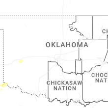
Oklahoma
| Local Time | Report Details |
|---|---|
| 5:50 PM CDT | Bessie mesone in washita county OK, 73.2 miles SSE of Woodward, OK |
| 6:25 PM CDT | Bessie mesone in washita county OK, 73.2 miles SSE of Woodward, OK |
| 7:03 PM CDT | Storm damage reported in washita county OK, 76.2 miles S of Woodward, OK |
| 7:20 PM CDT | Storm damage reported in beckham county OK, 75.4 miles S of Woodward, OK |
| 7:44 PM CDT | Storm damage reported in beckham county OK, 69.2 miles S of Woodward, OK |
| 7:45 PM CDT | Storm damage reported in beckham county OK, 74.7 miles S of Woodward, OK |
| 9:15 PM CDT | Storm damage reported in caddo county OK, 54.1 miles W of Oklahoma City, OK |
| 11:55 PM CDT | Storm damage reported in ottawa county OK, 63.9 miles SSE of Chanute, KS |
| 12:12 AM CDT | Power outages and a report of a power pole down. some lightning was observed in glm data at the time of the repor in ottawa county OK, 62.3 miles SE of Chanute, KS |
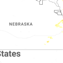
Nebraska
| Local Time | Report Details |
|---|---|
| 6:10 PM CDT | Quarter sized hail reported near Union, NE, 31.3 miles S of Omaha, NE |
| 7:02 PM CDT | Public weather statio in stanton county NE, 81.3 miles ESE of Oneill, NE |
| 7:30 PM CDT | Quarter sized hail reported near Bruning, NE, 57.1 miles SE of Grand Island, NE, delayed report of 1 hail from social media image. |
| 8:28 PM CDT | Quarter sized hail reported near Milford, NE, 63.3 miles E of Grand Island, NE, hailstone compared to quarter. |
| 10:06 PM CDT | Quarter sized hail reported near Fremont, NE, 32.6 miles WNW of Omaha, NE |
Wisconsin
| Local Time | Report Details |
|---|---|
| 11:47 PM CDT | Home weather station pws-kwipotos in grant county WI, 69.3 miles WSW of Madison, WI |
| 11:50 PM CDT | Storm damage reported in grant county WI, 57.7 miles WSW of Madison, WI |
| 11:53 PM CDT | Storm damage reported in grant county WI, 57.7 miles WSW of Madison, WI |
| 12:36 AM CDT | Corrects previous non-tstm wnd gst report from 1 ene dodgeville. mesonet station ap090 madiso in iowa county WI, 37.8 miles W of Madison, WI |
| 12:45 AM CDT | Mesonet station wighm brigha in iowa county WI, 24 miles WSW of Madison, WI |
Illinois
| Local Time | Report Details |
|---|---|
| 5:09 AM CDT | Damage to an outbuilding... and a one hundred ft radio tower downe in marshall county IL, 23.8 miles N of Peoria, IL |
| 5:10 AM CDT | 3 power poles down... and some damage to a nearby outbuildin in marshall county IL, 24.1 miles NNE of Peoria, IL |
| 5:25 AM CDT | Several large trees down across washbur in woodford county IL, 22.2 miles NE of Peoria, IL |
Connect with Interactive Hail Maps