

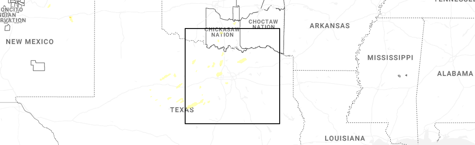
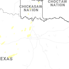
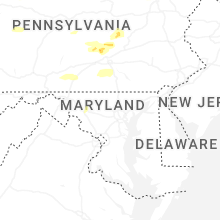
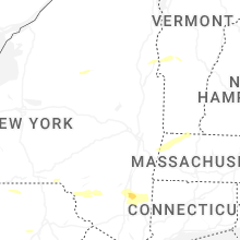
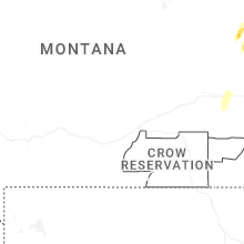
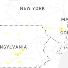
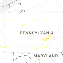
Hail Map for Saturday, June 6, 2026
Number of Impacted Households on 6/6/2026
0
Impacted by 1" or Larger Hail
0
Impacted by 1.75" or Larger Hail
0
Impacted by 2.5" or Larger Hail
Square Miles of Populated Area Impacted on 6/6/2026
0
Impacted by 1" or Larger Hail
0
Impacted by 1.75" or Larger Hail
0
Impacted by 2.5" or Larger Hail


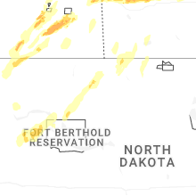
Cities Most Affected by Hail Storms of 6/6/2026
| Hail Size | Demographics of Zip Codes Affected | ||||||
|---|---|---|---|---|---|---|---|
| City | Count | Average | Largest | Pop Density | House Value | Income | Age |
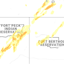
| Circle, MT | 1 | 2.00 | 2.00 | 0 | $43k | $28.5k | 47.1 |
| Fortuna, ND | 1 | 1.75 | 1.75 | 0 | $10k | $26.3k | 50.5 |
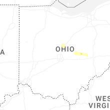
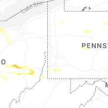
| Galena, OH | 1 | 1.75 | 1.75 | 311 | $218k | $69.0k | 39.5 |
Hail and Wind Damage Spotted on 6/6/2026
Filter by Report Type:Hail ReportsWind Reports
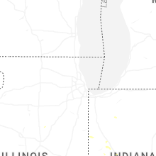
States Impacted
Indiana, Ohio, Pennsylvania, West Virginia, Maryland, New York, Wyoming, Virginia, Connecticut, New Jersey, Utah, Oklahoma, Vermont, New Hampshire, Montana, Texas, Arkansas, North Dakota, Massachusetts, South DakotaIndiana
| Local Time | Report Details |
|---|---|
| 9:15 AM EDT | Awos station kmzz grant county municipal ap in grant county IN, 51.2 miles SW of Fort Wayne, IN |
| 9:15 AM EDT | A few large tree branches (with some rot visible in picture) reported down near west 14th street and jackson street in marion. time estimated via rada in grant county IN, 47 miles SW of Fort Wayne, IN |
| 3:08 PM EDT | Storm damage reported in benton county IN, 85.6 miles NW of Indianapolis, IN |
| 3:10 PM EDT | Power outages reported in fowler. pea size hail also observe in benton county IN, 85.4 miles NW of Indianapolis, IN |
| 3:15 PM EDT | Multiple power poles down north of fowler on sr55. also reports of various lines down in tow in benton county IN, 86.4 miles NW of Indianapolis, IN |
| 3:15 PM EDT | Roof and doors blown off storage unit on northwest side of fowle in benton county IN, 85.8 miles NW of Indianapolis, IN |
| 3:15 PM EDT | Picture of several tree limbs downe in tippecanoe county IN, 58.7 miles NW of Indianapolis, IN |
| 4:53 PM EDT | Late report of peak gust at kmie munci in delaware county IN, 51.9 miles NE of Indianapolis, IN |
| 6:40 PM EDT | Numerous trees dow in warren county IN, 77.9 miles WNW of Indianapolis, IN |
Ohio
| Local Time | Report Details |
|---|---|
| 11:55 AM EDT | Osu airpor in franklin county OH, 8.9 miles NNW of Columbus, OH |
| 11:55 AM EDT | Report of large tree down on power lines along state route 314 north of spart in morrow county OH, 34 miles NNE of Columbus, OH |
| 11:57 AM EDT | Report of multiple trees down on state route 19 northeast of spart in morrow county OH, 35.6 miles NNE of Columbus, OH |
| 12:02 PM EDT | Large tree and power pole down near denune and joyce avenue in franklin county OH, 4.6 miles NNE of Columbus, OH |
| 12:08 PM EDT | Large tree and power lines down on state route 13 between mount vernon and green valle in knox county OH, 41.3 miles NE of Columbus, OH |
| 12:10 PM EDT | Large tree down due to thunderstorm win in franklin county OH, 8.2 miles NE of Columbus, OH |
| 12:17 PM EDT | Extensive roof damage to a building along with surrounding tree damage with limbs down. time estimated via rada in knox county OH, 42.4 miles NE of Columbus, OH |
| 12:29 PM EDT | Trees down. time estimated from rada in licking county OH, 30.2 miles E of Columbus, OH |
| 12:32 PM EDT | Trees and power lines down. time estimated from rada in licking county OH, 32.2 miles ENE of Columbus, OH |
| 12:34 PM EDT | Trees down. time estimated from rada in licking county OH, 39.9 miles ENE of Columbus, OH |
| 12:37 PM EDT | A number of trees down on route 58 in muskingum county OH, 44.8 miles ENE of Columbus, OH |
| 12:37 PM EDT | Tree(s) down on township rd 29 in bethlehem township. time based on radar estimat in coshocton county OH, 62.3 miles ENE of Columbus, OH |
| 12:37 PM EDT | Branch fell on power line on county route 28 in bethlehem township. time based on radar estimat in coshocton county OH, 61.5 miles ENE of Columbus, OH |
| 12:37 PM EDT | Tree(s) down on county road 436 and county road 14. time based on radar estimat in coshocton county OH, 50.9 miles ENE of Columbus, OH |
| 12:40 PM EDT | Trees down on scout roa in muskingum county OH, 48.7 miles ENE of Columbus, OH |
| 12:44 PM EDT | Down power poles. report from mpin in muskingum county OH, 48.1 miles ENE of Columbus, OH |
| 12:45 PM EDT | 43 customers reported power outages from tree contact in the vicinity of county route 8 in perry county OH, 30 miles E of Columbus, OH |
| 12:47 PM EDT | Tree(s) down on cambridge road... coshocton... ohio. time based on radar estimat in coshocton county OH, 65.2 miles ENE of Columbus, OH |
| 12:47 PM EDT | Tree blocking road on south lawn ave... coshocton... ohio. time based on radar estimat in coshocton county OH, 63.7 miles ENE of Columbus, OH |
| 12:47 PM EDT | Tree(s) down between ash and alder street. time based on radar estimat in coshocton county OH, 63.9 miles ENE of Columbus, OH |
| 12:51 PM EDT | Trees uprooted on river roa in muskingum county OH, 54.5 miles E of Columbus, OH |
| 1:11 PM EDT | Trees down on lookout roa in muskingum county OH, 68.1 miles E of Columbus, OH |
| 1:23 PM EDT | Trees down reported along state routes near freeport. time based on radar estimate (note: second set of storms looked stronger... so going with that time in harrison county OH, 69 miles WSW of Pittsburgh, PA |
| 1:24 PM EDT | Trees down on glenn highway and savage roa in guernsey county OH, 71.9 miles E of Columbus, OH |
| 1:38 PM EDT | Tree and power lines down on clairmont ave and clark stree in guernsey county OH, 75.7 miles E of Columbus, OH |
| 1:42 PM EDT | Trees down along state route 146 in whigsville. time based on radar estimat in noble county OH, 83.9 miles WSW of Pittsburgh, PA |
| 1:42 PM EDT | Boat capsized on senecaville lak in guernsey county OH, 83.5 miles WSW of Pittsburgh, PA |
| 1:46 PM EDT | Trees down along state route 146 in summerfield. time based on radar estimat in noble county OH, 83.6 miles WSW of Pittsburgh, PA |
| 1:56 PM EDT | Tree down on county road 1 in rayland. time based on radar estimat in jefferson county OH, 41.2 miles WSW of Pittsburgh, PA |
| 1:56 PM EDT | Trees down on county roads 15 & 16. time based on radar estimat in jefferson county OH, 40.4 miles WSW of Pittsburgh, PA |
| 1:56 PM EDT | Trees down reported in miltonsburg as well as other areas scattered around the county. time based on radar estimate in miltonsbur in monroe county OH, 74.9 miles SW of Pittsburgh, PA |
| 1:56 PM EDT | Trees and lines down in the bethesda are in belmont county OH, 64.1 miles WSW of Pittsburgh, PA |
| 1:57 PM EDT | Mount hope rd trees and power lines dow in belmont county OH, 58.6 miles WSW of Pittsburgh, PA |
| 1:57 PM EDT | Tree and power lines down near somerto in belmont county OH, 71 miles WSW of Pittsburgh, PA |
| 2:00 PM EDT | Power lines down on lafferty r in belmont county OH, 58.6 miles WSW of Pittsburgh, PA |
| 2:05 PM EDT | Tree down in stuebenville. time based on radar estimat in jefferson county OH, 34.7 miles W of Pittsburgh, PA |
| 2:15 PM EDT | Person trapped under tree near key-bellaire roa in belmont county OH, 55.9 miles SW of Pittsburgh, PA |
| 4:20 PM EDT | Numerous trees down on the north side of urbana... with the damage confined to an area largely between washington and bloomfield avenues... west of north main stree in champaign county OH, 41.1 miles WNW of Columbus, OH |
| 4:58 PM EDT | Tree down across lombard chuckery roa in madison county OH, 22.1 miles WNW of Columbus, OH |
| 5:02 PM EDT | Tree down across state route 29 near thorn locus lan in madison county OH, 21.1 miles W of Columbus, OH |
| 5:07 PM EDT | Numerous reports of tree damage throughout dublin. time estimated from rada in franklin county OH, 11.1 miles NNW of Columbus, OH |
| 5:07 PM EDT | 10 to 12 trees down and uprooted near the intersection of brand road and muirfield driv in franklin county OH, 14 miles NW of Columbus, OH |
| 5:12 PM EDT | Half Dollar sized hail reported near Dublin, OH, 9.7 miles NW of Columbus, OH, report from mping: half dollar (1.25 in.). |
| 5:12 PM EDT | Half Dollar sized hail reported near Powell, OH, 15 miles NNW of Columbus, OH |
| 5:22 PM EDT | Large branches down along meadow park avenue in lewis center. time estimated from rada in delaware county OH, 13.7 miles N of Columbus, OH |
| 5:27 PM EDT | Numerous trees down in baltimor in fairfield county OH, 22.8 miles ESE of Columbus, OH |
| 5:36 PM EDT | Golf Ball sized hail reported near Galena, OH, 17.3 miles NNE of Columbus, OH |
| 5:42 PM EDT | Tree branches down near baltimor in fairfield county OH, 22.8 miles ESE of Columbus, OH |
| 5:44 PM EDT | Utility pole down on johnsons island. time estimated via rada in ottawa county OH, 54.4 miles W of Cleveland, OH |
| 5:48 PM EDT | Power poles down along south bird roa in clark county OH, 38.7 miles W of Columbus, OH |
| 5:48 PM EDT | Trees down along croft road northeast of springfield. time estimate from rada in clark county OH, 40.2 miles W of Columbus, OH |
| 5:51 PM EDT | Numerous large limbs and trees down throughout springfield. time estimated from rada in clark county OH, 42.9 miles W of Columbus, OH |
| 5:52 PM EDT | Tree down on house. time estimated via rada in erie county OH, 53 miles W of Cleveland, OH |
| 5:54 PM EDT | Mesonet station xsdb 2 nne sandusky marine wind gust of 56 knot in lez144 county OH, 52.4 miles W of Cleveland, OH |
| 5:59 PM EDT | Mesonet station au939 sandusky wind gust to 50 knot in erie county OH, 49.5 miles W of Cleveland, OH |
| 6:00 PM EDT | Report of tree down on winegardner road. time estimated from rada in perry county OH, 36 miles ESE of Columbus, OH |
| 6:07 PM EDT | Damage to roof of barn in south vienna by sylvan shores near old columbus road. time estimated from rada in clark county OH, 31.2 miles W of Columbus, OH |
| 6:10 PM EDT | Report of downed limbs and high water on mainesville road. time estimated from rada in perry county OH, 41.1 miles ESE of Columbus, OH |
| 6:14 PM EDT | Trees down along state route 41 just north of south charleston. time estimated from rada in clark county OH, 34.9 miles WSW of Columbus, OH |
| 6:22 PM EDT | Tree down across dempsey road. time estimated via rada in ottawa county OH, 55.5 miles W of Cleveland, OH |
| 6:25 PM EDT | 54 customers reported power outages near county route 668... township highway 184... and township rd 131... due to tree contact between 625 and 642 p in perry county OH, 43.1 miles ESE of Columbus, OH |
| 6:30 PM EDT | 4 inch tree limb down along wayne trace road and state route 122. time estimated from rada in preble county OH, 42.7 miles N of Cincinnati, OH |
| 6:30 PM EDT | Damage to a bar in henry county OH, 57.7 miles ENE of Fort Wayne, IN |
| 6:30 PM EDT | Tree down east consolidated rd. near wayne rd. time estimated from rada in preble county OH, 42 miles N of Cincinnati, OH |
| 6:31 PM EDT | Tree down on route 35 near rebecca road. time estimated from rada in preble county OH, 43.8 miles N of Cincinnati, OH |
| 6:40 PM EDT | Report of tree down on township road 128. time estimated from rada in perry county OH, 45.8 miles ESE of Columbus, OH |
| 7:10 PM EDT | Quarter sized hail reported near New Concord, OH, 68.1 miles E of Columbus, OH |
| 7:40 PM EDT | Tree/power lines down approx 2-3 mi s of bethesda. time based on report and radar estimat in belmont county OH, 65.8 miles WSW of Pittsburgh, PA |
| 9:35 PM EDT | Emergency management reported a few power lines down along with a tree in van wert. time estimated from rada in van wert county OH, 31 miles ESE of Fort Wayne, IN |
Pennsylvania
| Local Time | Report Details |
|---|---|
| 12:42 PM EDT | Reports of tree down along kennedy hill road near krider roa in crawford county PA, 79.2 miles E of Cleveland, OH |
| 12:42 PM EDT | Reports of tree down on pettis roads between west oil creek road and smith roa in crawford county PA, 79.6 miles N of Pittsburgh, PA |
| 1:10 PM EDT | Report of trees down on wires on shaffer road near barco road southwest of meadvill in crawford county PA, 77.9 miles N of Pittsburgh, PA |
| 1:10 PM EDT | Report of tree down on wire causing fire on mercer pike near willow way south of meadvill in crawford county PA, 78.6 miles N of Pittsburgh, PA |
| 1:25 PM EDT | Report of tree down on adamsville road near pickasaw lane southeast of conneaut lak in crawford county PA, 73.2 miles E of Cleveland, OH |
| 1:35 PM EDT | Trees and wires dow in warren county PA, 85.7 miles SSW of Buffalo, NY |
| 1:37 PM EDT | Tree down on interstate 79 northbound near mile marker 13 in crawford county PA, 75.2 miles N of Pittsburgh, PA |
| 1:41 PM EDT | Trees down in northern highland township. time estimated by rada in elk county PA, 76.2 miles NW of State College, PA |
| 2:00 PM EDT | A couple of trees down in rouseville. time is based on radar best gues in venango county PA, 73 miles NNE of Pittsburgh, PA |
| 2:00 PM EDT | At least 5 different reports of trees down in cornplanter township... pa. time is based on radar best gues in venango county PA, 74.8 miles NNE of Pittsburgh, PA |
| 2:00 PM EDT | Uprooted trees on route 94 in forest county PA, 81.6 miles NW of State College, PA |
| 2:01 PM EDT | Numerous trees down along cherry run r in warren county PA, 83.3 miles NW of State College, PA |
| 2:06 PM EDT | Trees down in northern highland township. time estimated by rada in elk county PA, 76.2 miles NW of State College, PA |
| 2:15 PM EDT | Tree down in oil city. time based on rada in venango county PA, 70.1 miles NNE of Pittsburgh, PA |
| 2:20 PM EDT | Trees down with estimated wind of 70 mp in washington county PA, 30.9 miles SW of Pittsburgh, PA |
| 2:23 PM EDT | Power lines down on old national pik in washington county PA, 34.2 miles SW of Pittsburgh, PA |
| 2:26 PM EDT | Trees and wires down on webster hill road in moriss twp. time based on radar estimat in greene county PA, 37.3 miles SSW of Pittsburgh, PA |
| 2:26 PM EDT | Trees and wires down on baldwin hollow road in moriss twp. time based on radar estimat in greene county PA, 36.8 miles SSW of Pittsburgh, PA |
| 2:31 PM EDT | Trees down on central av in washington county PA, 21.9 miles SW of Pittsburgh, PA |
| 2:31 PM EDT | Wires down on wheeling creek rd near west roy furman hw in greene county PA, 45.6 miles SW of Pittsburgh, PA |
| 2:39 PM EDT | At least 5 trees down in waynesburg with time based on radar estimate. there are 20 additional reports of trees down scattered across greene count in greene county PA, 38.5 miles SSW of Pittsburgh, PA |
| 2:41 PM EDT | Corrects previous tstm wnd dmg report from james city. trees down in northern highland township. time estimated by rada in elk county PA, 76.2 miles NW of State College, PA |
| 2:42 PM EDT | Trees and power lines down. time estimated via rada in washington county PA, 23.7 miles S of Pittsburgh, PA |
| 2:43 PM EDT | Six inch diameter tree branch snapped and 20 foot diameter tree trunk snappe in washington county PA, 24.3 miles S of Pittsburgh, PA |
| 2:44 PM EDT | Trees and wires down on beallsville road. time estimated via rada in washington county PA, 23.4 miles S of Pittsburgh, PA |
| 2:49 PM EDT | Trees down in monessen. time based on rada in westmoreland county PA, 20.2 miles SSE of Pittsburgh, PA |
| 2:49 PM EDT | Videos and images posted on facebook of snapped and uprooted trees from ryes bar & grill (248 old national pike... brownsville... pa). time is radar estimate in washington county PA, 28.5 miles S of Pittsburgh, PA |
| 2:50 PM EDT | Trees and power lines down in crucible... p in greene county PA, 33.7 miles S of Pittsburgh, PA |
| 2:50 PM EDT | Trees reported down in rostraver twp. time based on rada in westmoreland county PA, 21.2 miles SSE of Pittsburgh, PA |
| 2:50 PM EDT | Tree down on vehicle on brownsville roa in fayette county PA, 29.4 miles S of Pittsburgh, PA |
| 2:51 PM EDT | Numerous reports of trees down across burnside... pa. time estimated by rada in clearfield county PA, 48.7 miles W of State College, PA |
| 2:54 PM EDT | Wires down hopewell roa in fayette county PA, 32.9 miles S of Pittsburgh, PA |
| 2:54 PM EDT | Trees reported down in sewickley twp... pa. time based on best guess from rada in westmoreland county PA, 18.7 miles SE of Pittsburgh, PA |
| 2:54 PM EDT | Building collapse on perry avenu in fayette county PA, 23.7 miles SSE of Pittsburgh, PA |
| 2:57 PM EDT | Trees down reported in south huntingdon twp. time based on best guess from rada in westmoreland county PA, 24.5 miles SE of Pittsburgh, PA |
| 2:57 PM EDT | Power lines down on pioneer lake r in indiana county PA, 52 miles W of State College, PA |
| 3:00 PM EDT | Trees dow in clearfield county PA, 35.7 miles W of State College, PA |
| 3:00 PM EDT | *** 1 inj *** corrects time of previous tstm wnd dmg report from 1 ese lynnwood-pricedale. glister road... mobile home rolled ove in fayette county PA, 23.7 miles SSE of Pittsburgh, PA |
| 3:02 PM EDT | Power lines down on arcadia r in indiana county PA, 50.5 miles W of State College, PA |
| 3:02 PM EDT | Power lines down on moyer r in indiana county PA, 50 miles W of State College, PA |
| 3:04 PM EDT | Trees down reported in north huntingdon. time based on rada in westmoreland county PA, 16.7 miles ESE of Pittsburgh, PA |
| 3:04 PM EDT | Images of uprooted and snapped trees on ferguson road in dunbar... p in fayette county PA, 38.3 miles SSE of Pittsburgh, PA |
| 3:05 PM EDT | Image of damaged hanger and a flipped cessna at the mt. pleasant/scottdale airport. time based on radar estimat in fayette county PA, 33.1 miles SE of Pittsburgh, PA |
| 3:05 PM EDT | Drone footage provided of substantial tree damage along banning road. possible tornad in fayette county PA, 26.4 miles SSE of Pittsburgh, PA |
| 3:05 PM EDT | Trees dow in clearfield county PA, 32.5 miles W of State College, PA |
| 3:05 PM EDT | Small trees (unclear how tall they are) in yard were sheare in fayette county PA, 33 miles SE of Pittsburgh, PA |
| 3:05 PM EDT | Spotter heard that on the east side of rte 119 (by rte 119 and kingview rd) 10 healthy trees were snapped about 15ft up. time based on radar estimat in fayette county PA, 33.4 miles SE of Pittsburgh, PA |
| 3:06 PM EDT | Several trees dow in fayette county PA, 38 miles SE of Pittsburgh, PA |
| 3:08 PM EDT | Trees and wires dow in clearfield county PA, 31 miles W of State College, PA |
| 3:10 PM EDT | Substantial roof damage and large tree limbs broken along route 119. time estimated via rada in westmoreland county PA, 31.3 miles SE of Pittsburgh, PA |
| 3:10 PM EDT | Shingles blown off of a house. time estimated via rada in westmoreland county PA, 31.3 miles SE of Pittsburgh, PA |
| 3:10 PM EDT | Roof ripped off of ace hardware. time estimated via rada in westmoreland county PA, 31.8 miles SE of Pittsburgh, PA |
| 3:15 PM EDT | Trees down in multiple locations in chest twp. time est from rada in cambria county PA, 40.9 miles W of State College, PA |
| 3:21 PM EDT | Numerous trees down in donega in westmoreland county PA, 39.7 miles SE of Pittsburgh, PA |
| 3:26 PM EDT | Numerous power lines dow in somerset county PA, 53.3 miles SE of Pittsburgh, PA |
| 3:29 PM EDT | Wires dow in somerset county PA, 54.9 miles SE of Pittsburgh, PA |
| 3:30 PM EDT | Tree down on barron church rd. time estimated by rada in somerset county PA, 52 miles SE of Pittsburgh, PA |
| 3:34 PM EDT | Wires dow in somerset county PA, 56.4 miles ESE of Pittsburgh, PA |
| 3:34 PM EDT | Trees dow in blair county PA, 21.9 miles WSW of State College, PA |
| 3:35 PM EDT | Wires dow in somerset county PA, 57.4 miles SE of Pittsburgh, PA |
| 3:36 PM EDT | Tree dow in somerset county PA, 56.8 miles ESE of Pittsburgh, PA |
| 3:37 PM EDT | Tree dow in somerset county PA, 51.3 miles ESE of Pittsburgh, PA |
| 3:37 PM EDT | 10-15 inch diameter trees and limbs down... along with numerous downed power lines around north center av in somerset county PA, 55.8 miles ESE of Pittsburgh, PA |
| 3:37 PM EDT | Trees and limbs down in several locations in westmont. time from first repor in cambria county PA, 55.9 miles E of Pittsburgh, PA |
| 3:40 PM EDT | Tree down on piersol r in somerset county PA, 59.7 miles ESE of Pittsburgh, PA |
| 3:40 PM EDT | Tree dow in centre county PA, 9.9 miles NNE of State College, PA |
| 3:40 PM EDT | Wires dow in somerset county PA, 58 miles ESE of Pittsburgh, PA |
| 3:41 PM EDT | Wires down on bald eagle mountain rd. time estimated by rada in clinton county PA, 24.7 miles NE of State College, PA |
| 3:45 PM EDT | Wires dow in clinton county PA, 33 miles NE of State College, PA |
| 3:47 PM EDT | Wires dow in clinton county PA, 33.2 miles NE of State College, PA |
| 3:48 PM EDT | Wires down by intersection of cabin hill rd and grandview d in somerset county PA, 75.9 miles SE of Pittsburgh, PA |
| 4:00 PM EDT | Trees dow in bedford county PA, 70 miles SW of State College, PA |
| 4:00 PM EDT | Trees down near bedford springs. time estimated by rada in bedford county PA, 64.3 miles SSW of State College, PA |
| 4:20 PM EDT | Trees down on big creek r in bedford county PA, 69.2 miles SSW of State College, PA |
| 4:21 PM EDT | Multiple trees and wires down near everet in bedford county PA, 58.3 miles SSW of State College, PA |
| 4:25 PM EDT | Several trees on wire in union county PA, 46.2 miles ENE of State College, PA |
| 4:25 PM EDT | Tree down on a vehicle on 1600 block of pa 40 in northumberland county PA, 53 miles ENE of State College, PA |
| 4:26 PM EDT | *** 1 inj *** glister road... mobile home rolled ove in fayette county PA, 23.7 miles SSE of Pittsburgh, PA |
| 4:27 PM EDT | Tree down on railing of i-70 eb near mm 15 in fulton county PA, 64.8 miles SSW of State College, PA |
| 4:28 PM EDT | Tree down in st thoma in franklin county PA, 60.3 miles S of State College, PA |
| 4:35 PM EDT | Trees dow in fulton county PA, 73.5 miles SSW of State College, PA |
| 4:35 PM EDT | Several trees on wire in union county PA, 51.8 miles ENE of State College, PA |
| 4:45 PM EDT | Numerous tree limbs down around avenue f in riverside... p in northumberland county PA, 59.7 miles WSW of Scranton, PA |
| 4:45 PM EDT | Numerous trees down by goodville rd and evans hollow rd. time estimated by rada in juniata county PA, 37.4 miles ESE of State College, PA |
| 4:45 PM EDT | Large tree down on the side of the road near the norland cemeter in franklin county PA, 58.7 miles SSE of State College, PA |
| 4:50 PM EDT | Several reports of trees down on west side of chambersburg. time of first repor in franklin county PA, 59.8 miles S of State College, PA |
| 5:08 PM EDT | Trees and wires down by roth rd. time estimated by rada in perry county PA, 45 miles SE of State College, PA |
| 5:11 PM EDT | Multiple reports of trees and limbs on wires in waynesboro. time est by rada in franklin county PA, 61.1 miles WNW of Baltimore, MD |
| 5:14 PM EDT | Corrects previous tstm wnd dmg report from 2 wnw franklintown. wires dow in york county PA, 60.1 miles NNW of Baltimore, MD |
| 5:15 PM EDT | Tree down by spring rd. time estimated by rada in perry county PA, 46.2 miles SE of State College, PA |
| 5:16 PM EDT | Multiple trees and wires down in frackville and shenandoa in schuylkill county PA, 52.7 miles SW of Scranton, PA |
| 5:17 PM EDT | Multiple trees and wires down across northern perry county south of new buffal in perry county PA, 49.9 miles ESE of State College, PA |
| 5:25 PM EDT | Tree down on henry roa in luzerne county PA, 35.6 miles SSW of Scranton, PA |
| 5:26 PM EDT | Corrects previous tstm wnd dmg report from 3 e wellsville. wires dow in york county PA, 55 miles NNW of Baltimore, MD |
| 5:30 PM EDT | Large tree limb down in yard... along side of york rd. time estimated by rada in adams county PA, 48.7 miles NW of Baltimore, MD |
| 5:30 PM EDT | Route 11/15 north is closed. there are several trees down heading into marysvill in perry county PA, 58.1 miles ESE of State College, PA |
| 5:40 PM EDT | Route 22/322 west is closed just east of dauphin borough after a tree fell onto a vehicl in dauphin county PA, 57.4 miles ESE of State College, PA |
| 5:40 PM EDT | Tree down on jonestown r in dauphin county PA, 66.8 miles ESE of State College, PA |
| 5:45 PM EDT | Multiple trees blown down along 534 through hickory run state park. time estimated from rada in carbon county PA, 26.3 miles S of Scranton, PA |
| 5:47 PM EDT | Multiple trees and wires down in and around pine grov in schuylkill county PA, 70.3 miles SSW of Scranton, PA |
| 5:52 PM EDT | Tree down - blocking both lane in berks county PA, 71.2 miles SSW of Scranton, PA |
| 5:53 PM EDT | Trees dow in lebanon county PA, 72.9 miles N of Baltimore, MD |
| 5:53 PM EDT | Tree down on roadwa in lebanon county PA, 72.8 miles N of Baltimore, MD |
| 5:54 PM EDT | Tree on wires - multiple trees dow in berks county PA, 77.1 miles SSW of Scranton, PA |
| 5:55 PM EDT | Tree down. time estimate in berks county PA, 77.1 miles SSW of Scranton, PA |
| 5:55 PM EDT | Reports of some trees down with a few blocked roads in hamburg and exeter township. also... house chimney struck by lightning in hamburg. time estimate in berks county PA, 61 miles SSW of Scranton, PA |
| 5:57 PM EDT | Tree down by the intersection of stone mill rd and overview d in dauphin county PA, 68.6 miles N of Baltimore, MD |
| 5:58 PM EDT | Metal roof blown off of single story unoccupied building on 6500 block of hokes r in york county PA, 33.4 miles NNW of Baltimore, MD |
| 6:00 PM EDT | Wires dow in york county PA, 39.7 miles NNW of Baltimore, MD |
| 6:00 PM EDT | Damage to several homes reported. the roof of one residence was blown off. another residence lost a chimney. video shows a possible gustnado or tornado. time estimated in berks county PA, 77.1 miles SSW of Scranton, PA |
| 6:01 PM EDT | Wires dow in york county PA, 39.7 miles NNW of Baltimore, MD |
| 6:07 PM EDT | Tree down on house with live wires on vinemont rd. time estimate in berks county PA, 73.9 miles NNE of Baltimore, MD |
| 6:10 PM EDT | Multiple trees blown down. time estimated from rada in monroe county PA, 31.4 miles SE of Scranton, PA |
| 6:10 PM EDT | Wires dow in york county PA, 40.9 miles NNW of Baltimore, MD |
| 6:10 PM EDT | Tree down on wire in lebanon county PA, 73.2 miles N of Baltimore, MD |
| 6:10 PM EDT | Tree dow in lebanon county PA, 72.1 miles NNE of Baltimore, MD |
| 6:10 PM EDT | Tree down on vehicl in lebanon county PA, 74.4 miles N of Baltimore, MD |
| 6:10 PM EDT | Tree dow in lebanon county PA, 76.2 miles N of Baltimore, MD |
| 6:11 PM EDT | Wires down with the wires sparking. via county fire scanner. time estimate in lehigh county PA, 54.7 miles S of Scranton, PA |
| 6:15 PM EDT | Tree down - tree down on vehicle. time estimated from rada in berks county PA, 75.7 miles S of Scranton, PA |
| 6:15 PM EDT | Several large branches blown down. time estimated from rada in monroe county PA, 38 miles SE of Scranton, PA |
| 6:15 PM EDT | Large branches were blown dow in northampton county PA, 53.5 miles SSE of Scranton, PA |
| 6:17 PM EDT | Tree down on wires on hickory drive. time estimated by rada in wayne county PA, 21.9 miles E of Scranton, PA |
| 6:20 PM EDT | Wires dow in lancaster county PA, 53.8 miles N of Baltimore, MD |
| 6:20 PM EDT | Wires dow in york county PA, 55 miles NNW of Baltimore, MD |
| 6:25 PM EDT | Wires dow in lancaster county PA, 51.9 miles NNE of Baltimore, MD |
| 6:25 PM EDT | Wires dow in lancaster county PA, 45.3 miles NNE of Baltimore, MD |
| 6:25 PM EDT | Wires dow in lancaster county PA, 54.6 miles NNE of Baltimore, MD |
| 6:25 PM EDT | Wires dow in lancaster county PA, 53.1 miles NNE of Baltimore, MD |
| 6:25 PM EDT | Wires dow in york county PA, 60.1 miles NNW of Baltimore, MD |
| 6:27 PM EDT | Tree into a house with lives wires. time given in repor in berks county PA, 77.7 miles S of Scranton, PA |
| 6:28 PM EDT | Tree down blocking 1 lane. time estimated from rada in berks county PA, 79.9 miles NE of Baltimore, MD |
| 6:35 PM EDT | Some trees blown down. time estimated from rada in chester county PA, 80.7 miles S of Scranton, PA |
| 6:35 PM EDT | Tree down at camp lee ma in pike county PA, 34.4 miles E of Scranton, PA |
| 6:37 PM EDT | Wires dow in pike county PA, 40.5 miles ESE of Scranton, PA |
| 6:37 PM EDT | Trees and wires down in porter townshi in pike county PA, 40.7 miles ESE of Scranton, PA |
| 6:40 PM EDT | Tree blown into wires. time estimated from rada in montgomery county PA, 78.8 miles S of Scranton, PA |
| 6:48 PM EDT | Wires blown down. time estimated from rada in chester county PA, 62.5 miles NE of Baltimore, MD |
| 6:50 PM EDT | Multiple reports of wires down in east whiteland township. time estimated from rada in chester county PA, 76.7 miles NE of Baltimore, MD |
| 6:50 PM EDT | Tree blown down...blocking a road. time estimated from rada in montgomery county PA, 80.1 miles S of Scranton, PA |
| 6:54 PM EDT | Tree down onto wires with wires sparking. via fire scanne in chester county PA, 76.3 miles NE of Baltimore, MD |
| 6:58 PM EDT | Some trees down reported near the chester county hospita in chester county PA, 71.4 miles NE of Baltimore, MD |
| 7:00 PM EDT | Multiple reports of trees down in multiple locations in bucks county... including buckingham township. time estimated from rada in bucks county PA, 61.9 miles WSW of Brooklyn, NY |
| 7:20 PM EDT | Multiple reports of downed trees in philadelphia. time estimated from rada in philadelphia county PA, 74.3 miles SW of Brooklyn, NY |
| 8:10 PM EDT | Quarter sized hail reported near Marianna, PA, 28.6 miles S of Pittsburgh, PA, report from mping. |
West Virginia
| Local Time | Report Details |
|---|---|
| 2:12 PM EDT | Trees reported down on fairmont pike (wv 88) and roads branching off this road. time based on radar estimat in marshall county WV, 47.1 miles SW of Pittsburgh, PA |
| 2:20 PM EDT | Trees reported down on waynesburg pike (us 250) and other roads branching off this road. time based on radar estimat in marshall county WV, 49.1 miles SW of Pittsburgh, PA |
| 2:20 PM EDT | Trees down reporte4d on irish ridge. time based on radar estimat in marshall county WV, 47 miles SW of Pittsburgh, PA |
| 2:28 PM EDT | Trees down on cameron ridge. time based on radar estimat in marshall county WV, 54.9 miles SW of Pittsburgh, PA |
| 2:31 PM EDT | Trees down reported on fish creek road. time based on radar estimat in marshall county WV, 57.3 miles SW of Pittsburgh, PA |
| 2:57 PM EDT | Tree down on route 2 in wetzel county WV, 62.7 miles NW of Elkins, WV |
| 3:02 PM EDT | Tree across the roadway and top broke off electric pole; blocking whole road with power lines on road; power is out; additional tree down up the road; road closed. loca in monongalia county WV, 53.7 miles NNW of Elkins, WV |
| 3:16 PM EDT | Two lines down in the yard and power is out. location: 116 asa ln... farmington... wv. time based on radar estimat in marion county WV, 45.8 miles NNW of Elkins, WV |
| 3:20 PM EDT | Tree fell--one lane completely blocked; no wires involved. location: darst st / central ave... morgantown... wv. time based on radar estimat in monongalia county WV, 48.9 miles N of Elkins, WV |
| 3:23 PM EDT | Tree down blocking whole roadway; no lines involved. location near 221 opekiska ridge rd... fairmont... wv or 39.533234n/80.027643w. time based on radar estimat in monongalia county WV, 43.6 miles NNW of Elkins, WV |
| 3:25 PM EDT | *** 1 inj *** tents blown down at monongalia county baseball field. one person had 2 broken leg in monongalia county WV, 50.1 miles N of Elkins, WV |
| 3:56 PM EDT | Tree down near south preston highway and borgman roa in preston county WV, 36.7 miles N of Elkins, WV |
| 4:24 PM EDT | Tree and wires down on veterans memorial highway in wiley for in mineral county WV, 75.9 miles NE of Elkins, WV |
| 4:35 PM EDT | Tree down on south water and cliff street in keyse in mineral county WV, 58.5 miles NE of Elkins, WV |
| 4:42 PM EDT | Three trees down on martinsburg roa in morgan county WV, 81.6 miles S of State College, PA |
| 4:44 PM EDT | Several calls for trees down along river road in different location in morgan county WV, 78.1 miles S of State College, PA |
| 5:01 PM EDT | Two trees down in hedgesvill in berkeley county WV, 76 miles WNW of Baltimore, MD |
| 5:08 PM EDT | Three calls for trees down near glengar in berkeley county WV, 83.3 miles W of Baltimore, MD |
| 5:13 PM EDT | Four calls for different trees down near inwoo in berkeley county WV, 77.3 miles W of Baltimore, MD |
| 5:18 PM EDT | Large tree down at 177 border rd in jefferson county WV, 69.4 miles W of Baltimore, MD |
| 5:18 PM EDT | Tree down at 6445 charles town rd in jefferson county WV, 68.8 miles W of Baltimore, MD |
| 5:21 PM EDT | Tree down near intersection of daniel rd and shenandoah junc rd in jefferson county WV, 66.1 miles W of Baltimore, MD |
| 5:21 PM EDT | Large tree down near intersection of ridge rd and gardners ln in jefferson county WV, 66.3 miles W of Baltimore, MD |
| 5:21 PM EDT | Tree down on brucetown roa in jefferson county WV, 74.5 miles W of Baltimore, MD |
| 5:22 PM EDT | Large tree down at 1441 shepherd grade rd in jefferson county WV, 65.2 miles W of Baltimore, MD |
| 5:24 PM EDT | Tree down at 8008 shepherdstown pike in jefferson county WV, 64.9 miles W of Baltimore, MD |
| 2:17 AM EDT | Tree down blocking roadway. time estimated from rada in harrison county WV, 36.2 miles NW of Elkins, WV |
| 3:15 AM EDT | Tree down obstructing roadway. time estimated from radar. time reported 0358 a in taylor county WV, 30 miles NNW of Elkins, WV |
Maryland
| Local Time | Report Details |
|---|---|
| 3:35 PM EDT | Large tree down along trap run r in garrett county MD, 52.5 miles NNE of Elkins, WV |
| 3:46 PM EDT | Large tree down on brenneman rd near the bittinger fire department in garrett county MD, 57.4 miles NE of Elkins, WV |
| 4:04 PM EDT | Large tree down between lake dr and north bel air dr sw in allegany county MD, 70 miles NE of Elkins, WV |
| 4:11 PM EDT | Personal weather station at mountain lak in garrett county MD, 41.2 miles NE of Elkins, WV |
| 4:14 PM EDT | Tree down on garrett highway near blue ribbon road. road close in garrett county MD, 36.9 miles NE of Elkins, WV |
| 4:20 PM EDT | Over a dozen calls for trees down throughout allegany count in allegany county MD, 76.7 miles NE of Elkins, WV |
| 5:02 PM EDT | A wind gust of 61 knots (70 mph) was measured by the asos at hagerstown regional airport (khgr in washington county MD, 66.5 miles WNW of Baltimore, MD |
| 5:03 PM EDT | Large tree down along cedar lawn d in washington county MD, 66.3 miles WNW of Baltimore, MD |
| 5:15 PM EDT | Approximately 12...000 without power across the county. numerous downed trees and powerlines. additional reports of damage are being gathered by local official in washington county MD, 64.1 miles WNW of Baltimore, MD |
| 5:21 PM EDT | Washington county 911 reported over 100 storm related calls for damag in washington county MD, 64.1 miles WNW of Baltimore, MD |
| 5:50 PM EDT | County em reports over 9300 power outages across the county... with numerous trees/wires downed... blocking many roadways. additional reports of damage are being gather in frederick county MD, 44.5 miles WNW of Baltimore, MD |
| 5:57 PM EDT | Trained spotter reported numerous large trees down in ijamsvill in frederick county MD, 38.7 miles W of Baltimore, MD |
| 5:59 PM EDT | Multiple trees down in northern mancheste in carroll county MD, 30.8 miles NNW of Baltimore, MD |
| 6:05 PM EDT | Report of large tree downed onto 21000th block of club hollow road. tree is blocking road... and knocked some wires dow in montgomery county MD, 46.4 miles WSW of Baltimore, MD |
| 6:10 PM EDT | Report of tree and wires down at intersection of old hundred rd and barnesville r in montgomery county MD, 41.6 miles W of Baltimore, MD |
| 6:15 PM EDT | Multiple trees down north of reisterstow in baltimore county MD, 18.2 miles NW of Baltimore, MD |
| 6:21 PM EDT | Tree down onto road blocking it... near intersection of watkins mill rd and blunt roa in montgomery county MD, 34 miles WSW of Baltimore, MD |
| 6:23 PM EDT | Tree downed onto 7100 block of old stage roa in montgomery county MD, 33.4 miles WSW of Baltimore, MD |
| 6:38 PM EDT | Numerous trees down across forrest hill... m in harford county MD, 23.8 miles NNE of Baltimore, MD |
| 6:42 PM EDT | A couple of trees down along brighton dam road... between md-650 and howard county lin in montgomery county MD, 23.6 miles WSW of Baltimore, MD |
New York
| Local Time | Report Details |
|---|---|
| 5:08 PM EDT | Tree and wires down on trotting lane in napanoc in ulster county NY, 69.5 miles ENE of Scranton, PA |
| 5:11 PM EDT | Trees and wires down... possibly on fire. time estimated by rada in sullivan county NY, 63.7 miles ENE of Scranton, PA |
| 5:14 PM EDT | New york state department of transportation reported a downed tree and downed wires that blocked all lanes going both directions on ny 81 between cr 45 in coxsacki in greene county NY, 31.3 miles S of Schenectady, NY |
| 5:23 PM EDT | A ham radio operator reported a tree down on a house in ellenville... n in ulster county NY, 69.3 miles ENE of Scranton, PA |
| 5:28 PM EDT | Tree down near the ny state thruway near rosendal in ulster county NY, 66 miles S of Schenectady, NY |
| 5:28 PM EDT | Trees and wires down on route 32 near rosendal in ulster county NY, 66.7 miles S of Schenectady, NY |
| 5:30 PM EDT | Trees and wires down on cedar street in tillso in ulster county NY, 61 miles S of Schenectady, NY |
| 5:30 PM EDT | Report of tree and wires down along creek locks rd near bloomingto in ulster county NY, 66 miles S of Schenectady, NY |
| 5:31 PM EDT | Trees and wires down near mountain view rd near tillso in dutchess county NY, 63.8 miles S of Schenectady, NY |
| 5:33 PM EDT | Report of tree down on wires along route 213 near rifto in ulster county NY, 65.9 miles S of Schenectady, NY |
| 5:39 PM EDT | Tree and wires down on route 9w in the town of esopu in ulster county NY, 69.2 miles S of Schenectady, NY |
| 5:39 PM EDT | Tree and wires down on ulster avenue near port ewe in ulster county NY, 65.1 miles S of Schenectady, NY |
| 5:39 PM EDT | Report of more than a dozen trees down on mount academy campu in ulster county NY, 67.1 miles S of Schenectady, NY |
| 5:40 PM EDT | New york state department of transportation reported the closure of us 9w going in both directions between floyd ackert road and old post road due to a downed tre in ulster county NY, 69.9 miles S of Schenectady, NY |
| 5:41 PM EDT | Report of tree down between circle drive and vanderbilt lane on us in dutchess county NY, 69.9 miles S of Schenectady, NY |
| 6:13 PM EDT | Report of trees and power lines down in the ne corner of lagrange at union vaile borde in dutchess county NY, 67.4 miles N of Brooklyn, NY |
| 6:22 PM EDT | New york state department of transportation reported a tree down on ny 22 heading southbound north of dover furnace road... across from dover high school in dover plain in dutchess county NY, 72.1 miles NNE of Brooklyn, NY |
| 6:25 PM EDT | Multiple trees down... one on a house... along black point way in the town of putna in warren county NY, 48.8 miles SSW of Burlington, VT |
| 6:35 PM EDT | *** 2 inj *** a tree reportedly fell onto two people standing at the edge of their tents at the kittatinny campground riverside area causing injurie in sullivan county NY, 37.2 miles E of Scranton, PA |
| 7:37 PM EDT | Tree down and road closure on ny 416 both directions at ottaway lane (hamptonburgh) all lanes of 2 lanes closed. time estimated from rada in orange county NY, 55.6 miles NNW of Brooklyn, NY |
| 7:42 PM EDT | Mesonet station robn4 robbins reef... n in anz338 county NY, 4.3 miles WSW of Brooklyn, NY |
| 7:43 PM EDT | Trees and wires down blocking all lakes near jogee rd and mt orange rd in wawayanda orange count in orange county NY, 53.4 miles NNW of Brooklyn, NY |
| 7:44 PM EDT | Asos station klga nyc/la guardi in queens county NY, 8.4 miles NE of Brooklyn, NY |
| 7:45 PM EDT | Mesonet station fw2280 jersey cit in anz338 county NJ, 2.7 miles WNW of Brooklyn, NY |
| 7:50 PM EDT | Mesonet station xtpz tappan zee light 1 in westchester county NY, 31.4 miles N of Brooklyn, NY |
| 7:51 PM EDT | Mesonet station xlar larchmont harbo in anz335 county NY, 20.8 miles NE of Brooklyn, NY |
| 7:52 PM EDT | Tree down and road closure on ny 52 both directions east of meadow avenue (newburgh) all lanes of 2 lanes close in orange county NY, 57.2 miles N of Brooklyn, NY |
| 7:53 PM EDT | Multiple tree limbs down at holy ave and kissena blv in queens county NY, 9.5 miles NE of Brooklyn, NY |
| 7:55 PM EDT | Tree down on sprain brook state pkwy northbound north of tuckahoe road; cr 59 (yonkers) left lane of 3 lanes blocked. time estimated from rada in westchester county NY, 19.2 miles NNE of Brooklyn, NY |
| 7:55 PM EDT | Mesonet station quee kew garden hill in queens county NY, 9.3 miles ENE of Brooklyn, NY |
| 7:57 PM EDT | Irvington train station trees on track in westchester county NY, 24.8 miles NNE of Brooklyn, NY |
| 7:58 PM EDT | Tree down on bear mountain bridge roa in westchester county NY, 42 miles N of Brooklyn, NY |
| 8:01 PM EDT | Trees down on palisades parkway at exit 16. two lanes blocke in orange county NY, 42 miles N of Brooklyn, NY |
| 8:02 PM EDT | Mesonet station xbay bayvill in nassau county NY, 23.7 miles NE of Brooklyn, NY |
| 8:03 PM EDT | Asos station kjfk nyc/jfk airpor in queens county NY, 12.6 miles ESE of Brooklyn, NY |
| 8:05 PM EDT | Tree branches blocking roa in nassau county NY, 20.3 miles ENE of Brooklyn, NY |
| 8:14 PM EDT | Tree down and road closure on ny 137 both directions at deepwood road (bedford) all lanes of 2 lanes closed. time estimated by rada in westchester county NY, 41.5 miles NNE of Brooklyn, NY |
| 8:15 PM EDT | Downed tree and wire(s) at 87-35 108th st with structural damage to residenc in queens county NY, 7.9 miles E of Brooklyn, NY |
| 8:17 PM EDT | Tree down on ny 22 with 2 lanes blocke in westchester county NY, 33.6 miles NNE of Brooklyn, NY |
| 8:17 PM EDT | Mesonet station xeat eatons nec in suffolk county NY, 35.7 miles ENE of Brooklyn, NY |
| 8:22 PM EDT | Downed tree on bethpage state parkway southbound at exit b4 central avenue. 1 right lane of 2 lanes closed. time estimated by rada in nassau county NY, 27.5 miles E of Brooklyn, NY |
Wyoming
| Local Time | Report Details |
|---|---|
| 3:47 PM MDT | Mesonet station khld us20 hiland (dot in natrona county WY, 52.9 miles WNW of Casper, WY |
| 3:50 PM MDT | Mesonet station pc395 shoshone southfork (pc in park county WY, 103.4 miles NNW of Riverton, WY |
| 6:23 PM MDT | Storm damage reported in campbell county WY, 49.1 miles NNW of Gillette, WY |
| 7:32 PM MDT | Storm damage reported in crook county WY, 43.4 miles E of Gillette, WY |
| 7:56 PM MDT | Mesonet station dhs i-90 piney creek (dot in johnson county WY, 66 miles WNW of Gillette, WY |
| 8:26 PM MDT | Storm damage reported in laramie county WY, 34.7 miles ESE of Laramie, WY |
| 8:35 PM MDT | Storm damage reported in laramie county WY, 39.6 miles ESE of Laramie, WY |
| 8:49 PM MDT | Storm damage reported in weston county WY, 58.7 miles WSW of Rapid City, SD |
| 8:49 PM MDT | Storm damage reported in laramie county WY, 47.5 miles ESE of Laramie, WY |
| 8:53 PM MDT | Cheyenne asos reported peak gust of 66 mph in the wake of a thunderstor in laramie county WY, 42.1 miles ESE of Laramie, WY |
| 9:35 PM MDT | Storm damage reported in custer county SD, 41 miles WSW of Rapid City, SD |
Virginia
| Local Time | Report Details |
|---|---|
| 5:57 PM EDT | Several trees and power lines reported down near lucketts. over 800 customers without powe in loudoun county VA, 49.6 miles W of Baltimore, MD |
Connecticut
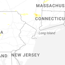
| Local Time | Report Details |
|---|---|
| 6:28 PM EDT | Wires down with power outages per eversource. time estimated by rada in fairfield county CT, 60.9 miles NNE of Brooklyn, NY |
| 6:39 PM EDT | Tree down on wires on old turnpike road near banta in litchfield county CT, 80.5 miles NNE of Brooklyn, NY |
| 7:35 PM EDT | Tree downed on a house and car on mitchell st with damage sustained to the house. relayed by amateur radi in hartford county CT, 65.1 miles W of Providence, RI |
| 7:35 PM EDT | Tree down on wire in hartford county CT, 64.9 miles W of Providence, RI |
| 7:40 PM EDT | Power outages due to downed tree limbs. time estimated by rada in middlesex county CT, 66.9 miles WSW of Providence, RI |
| 7:40 PM EDT | Tree limb down on roadway on washington street in middletown c in middlesex county CT, 67.6 miles WSW of Providence, RI |
| 8:20 PM EDT | Mesonet site xgll at greens ledge ligh in anz335 county CT, 37.5 miles NE of Brooklyn, NY |
| 8:35 PM EDT | Picture of large tree down in yar in fairfield county CT, 34.1 miles NE of Brooklyn, NY |
New Jersey
| Local Time | Report Details |
|---|---|
| 6:30 PM EDT | Several wires and poles blown down. time estimated from rada in warren county NJ, 52.2 miles W of Brooklyn, NY |
| 6:35 PM EDT | Large tree and wires blown down. time estimated from rada in warren county NJ, 51.6 miles W of Brooklyn, NY |
| 6:49 PM EDT | Nj dot - stmc: downed wires on nj 57 westbound west of allen rd/newburg rd (mansfield twp)... all lanes closed. time estimate in warren county NJ, 45.4 miles WNW of Brooklyn, NY |
| 6:54 PM EDT | Multiple reports of trees and wires down in washington. time estimate in warren county NJ, 52.2 miles W of Brooklyn, NY |
| 6:57 PM EDT | Nj dot - stmc: downed tree on i-78 eastbound west of exit 26 - cr 665/rattlesnake bridge rd (readington twp)... 1 right lane of 3 lanes closed. time estimated from rada in hunterdon county NJ, 39 miles W of Brooklyn, NY |
| 7:02 PM EDT | Nj dot - stmc: downed tree on nj 10 eastbound at in the vicinity of mount pleasant tpke (denville twp)... 2 right lanes of 3 lanes closed. time estimate in morris county NJ, 30.4 miles WNW of Brooklyn, NY |
| 7:05 PM EDT | Multiple trees and branches blown down in the boonton and mountain lakes area. time estimated from rada in morris county NJ, 26.3 miles WNW of Brooklyn, NY |
| 7:05 PM EDT | Multiple reports of trees down around bridgewater. time estimated from rada in somerset county NJ, 34.4 miles WSW of Brooklyn, NY |
| 7:07 PM EDT | Nj dot - stmc: downed tree on i-287 southbound north of exit 47 - us 202 (montville twp)... 2 right lanes of 3 lanes closed. time estimate in morris county NJ, 24.9 miles NW of Brooklyn, NY |
| 7:22 PM EDT | Video of a large tree snapping in strong win in passaic county NJ, 22.4 miles NW of Brooklyn, NY |
| 7:28 PM EDT | Tree blown down in delanco. time estimated from rada in burlington county NJ, 67.3 miles SW of Brooklyn, NY |
| 7:30 PM EDT | Tree blown down in cinnaminso in burlington county NJ, 71.2 miles SW of Brooklyn, NY |
| 7:30 PM EDT | Damaging winds caused damage to roof and vehicle. report from mpin in burlington county NJ, 54.7 miles SW of Brooklyn, NY |
| 7:34 PM EDT | Asos station kteb teterboro airpor in bergen county NJ, 12.1 miles NNW of Brooklyn, NY |
| 7:35 PM EDT | Asos station kewr newark airpor in union county NJ, 9.5 miles W of Brooklyn, NY |
| 7:36 PM EDT | Tree debris on glennside av in union county NJ, 20 miles W of Brooklyn, NY |
| 7:37 PM EDT | Downed tree along berkeley road... river edge n in bergen county NJ, 15.9 miles N of Brooklyn, NY |
| 7:43 PM EDT | Trees and wires down at millbrook ct and west northfield av in essex county NJ, 19.1 miles WNW of Brooklyn, NY |
| 7:43 PM EDT | Tree across roadway where robin hood road meets route 2 in union county NJ, 19.4 miles W of Brooklyn, NY |
| 7:45 PM EDT | Downed tree on nj 17 southbound south of pasaic street. 1 right lane of 2 lanes close in bergen county NJ, 15.7 miles NNW of Brooklyn, NY |
| 7:45 PM EDT | Tree blown into a home. time estimated from rada in monmouth county NJ, 32.7 miles SSW of Brooklyn, NY |
| 7:45 PM EDT | Tree blown down in springfield townshi in burlington county NJ, 56.9 miles SW of Brooklyn, NY |
| 7:45 PM EDT | Very large branch was blown down. time estimated from rada in monmouth county NJ, 32.2 miles SSW of Brooklyn, NY |
| 7:49 PM EDT | Large tree blown into a house. wind from outflow boundary ahead of the rai in monmouth county NJ, 18.9 miles SSW of Brooklyn, NY |
| 7:51 PM EDT | Tree on transformer - montgomery stree in hudson county NJ, 3.8 miles WNW of Brooklyn, NY |
| 7:52 PM EDT | Tree on house - belmar stree in bergen county NJ, 18.5 miles N of Brooklyn, NY |
| 7:54 PM EDT | Trees and wires down. island avenue and west end av in passaic county NJ, 17.7 miles NW of Brooklyn, NY |
| 7:59 PM EDT | Tree on house along putnam av in union county NJ, 23.1 miles WSW of Brooklyn, NY |
| 8:00 PM EDT | Report of a tree down in pemberto in burlington county NJ, 58.8 miles SSW of Brooklyn, NY |
Utah
| Local Time | Report Details |
|---|---|
| 4:45 PM MDT | Upr site along i-80 gusted to 66mp in tooele county UT, 88.8 miles W of Salt Lake City, UT |
| 5:14 PM MDT | I-80 @ grassey site gusted to 71mph. time estimated with rada in tooele county UT, 58.9 miles W of Salt Lake City, UT |
| 5:38 PM MDT | 70mph wind gust observed from dugway roadside sensor along i-80. approximate time estimated from rada in tooele county UT, 83 miles W of Salt Lake City, UT |
| 5:58 PM MDT | Aragonite raws measured a 58mph wind gus in tooele county UT, 60.5 miles W of Salt Lake City, UT |
| 6:22 PM MDT | Udot grassey @ i-80 gusted to 64mp in tooele county UT, 58.9 miles W of Salt Lake City, UT |
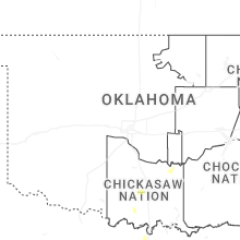
Oklahoma
| Local Time | Report Details |
|---|---|
| 6:05 PM CDT | Large door blown off of recycling center. time estimated from mesone in pontotoc county OK, 40.7 miles NW of Atoka, OK |
| 6:05 PM CDT | Street signs blown down at oak and 32nd. time estimated from ada mesone in pontotoc county OK, 41.1 miles NW of Atoka, OK |
| 6:05 PM CDT | Multiple trees and powerlines down in ada and pickett. minor damage to a store. time estimated by ada mesonet peak gust tim in pontotoc county OK, 41.6 miles NW of Atoka, OK |
| 8:50 PM CDT | Koja (thomas stafford airport) awos observatio in custer county OK, 65 miles W of Oklahoma City, OK |
Vermont
| Local Time | Report Details |
|---|---|
| 7:52 PM EDT | Delayed report of a very large tree that fell onto power lines and took down four utility poles on the 200 block of depot street in bennington. time estimated from rada in bennington county VT, 37.9 miles E of Schenectady, NY |
New Hampshire
| Local Time | Report Details |
|---|---|
| 8:25 PM EDT | Wires down on nh-10... road close in grafton county NH, 69.5 miles SE of Burlington, VT |
| 8:57 PM EDT | Two trees down on interstate 93 north... blocking several lane in grafton county NH, 71.7 miles W of Portland, ME |
| 9:00 PM EDT | Large tree down. spotter id: gr8 in grafton county NH, 74.2 miles WNW of Portland, ME |
Montana
| Local Time | Report Details |
|---|---|
| 6:41 PM MDT | Awos station k1km 2 ene harlowto in wheatland county MT, 77.3 miles NW of Billings, MT |
| 8:30 PM MDT | Quarter sized hail reported near Lindsay, MT, 72.5 miles NNE of Miles City, MT, rain 0.25... not much wind. hail for 10 minutes. |
| 9:05 PM MDT | Half Dollar sized hail reported near Culbertson, MT, 44.4 miles W of Williston, ND, with heavy rain and power outage. |
| 9:35 PM MDT | Awos station kpwd plentywoo in sheridan county MT, 60.1 miles NW of Williston, ND |
| 9:50 PM MDT | Hen Egg sized hail reported near Circle, MT, 66.1 miles N of Miles City, MT |
| 9:55 PM MDT | Quarter sized hail reported near Circle, MT, 71 miles N of Miles City, MT |
| 10:00 PM MDT | Quarter sized hail reported near Circle, MT, 70 miles SE of Glasgow, MT |
| 1:30 AM MDT | Quarter sized hail reported near Culbertson, MT, 41.5 miles W of Williston, ND, social media reports of hail the size of quarters. |
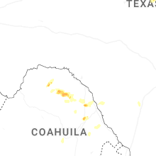
Texas
| Local Time | Report Details |
|---|---|
| 7:45 PM CDT | Facebook photo showed carport destroyed on cr 51 in johnson county TX, 27.3 miles SW of Dallas, TX |
| 8:23 PM CDT | Half Dollar sized hail reported near Red Oak, TX, 15.5 miles SSW of Dallas, TX, facebook photo showed half dollar size hail fell on berkeley dr in glenn heights. |
| 8:25 PM CDT | Quarter sized hail reported near Desoto, TX, 14.6 miles S of Dallas, TX, quarter sized hail and minor tree limb damage reported along mccowan park. |
| 8:35 PM CDT | Quarter sized hail reported near Red Oak, TX, 17.8 miles S of Dallas, TX, quarter size hail in red oak on i-35. |
| 10:54 PM CDT | Storm damage reported in lubbock county TX, 11.3 miles W of Lubbock, TX |
| 12:11 AM CDT | Tree down and blocking hwy 37 near cr483 in wood county TX, 86.4 miles E of Dallas, TX |
Arkansas
| Local Time | Report Details |
|---|---|
| 8:13 PM CDT | Tree reported down on highway 270 near the community of eagleto in polk county AR, 49.1 miles S of Fort Smith, AR |
| 9:15 PM CDT | A tree was reported down near this location onto east 1st street in waldro in scott county AR, 38.3 miles SSE of Fort Smith, AR |
North Dakota
| Local Time | Report Details |
|---|---|
| 8:20 PM CDT | Golf Ball sized hail reported near Fortuna, ND, 52.7 miles N of Williston, ND, relayed to nws by broadcast media partner. |
| 8:35 PM CDT | Ping Pong Ball sized hail reported near Ambrose, ND, 56.6 miles N of Williston, ND |
Massachusetts
| Local Time | Report Details |
|---|---|
| 10:10 PM EDT | Tree down blocking both lanes of travel in the vicinity of 2 millbury street. relayed by amateur radi in worcester county MA, 33.7 miles NW of Providence, RI |
South Dakota
| Local Time | Report Details |
|---|---|
| 12:12 AM MDT | Storm damage reported in butte county SD, 51 miles N of Rapid City, SD |
Connect with Interactive Hail Maps