

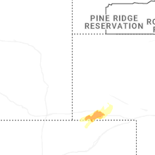
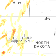
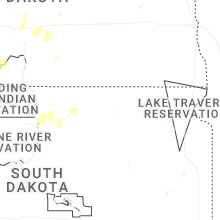
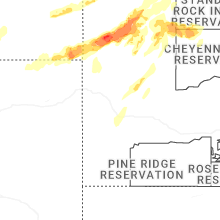
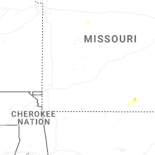
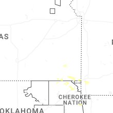
Hail Map for Sunday, June 7, 2026

Number of Impacted Households on 6/7/2026
0
Impacted by 1" or Larger Hail
0
Impacted by 1.75" or Larger Hail
0
Impacted by 2.5" or Larger Hail
Square Miles of Populated Area Impacted on 6/7/2026
0
Impacted by 1" or Larger Hail
0
Impacted by 1.75" or Larger Hail
0
Impacted by 2.5" or Larger Hail
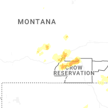
Cities Most Affected by Hail Storms of 6/7/2026
| Hail Size | Demographics of Zip Codes Affected | ||||||
|---|---|---|---|---|---|---|---|
| City | Count | Average | Largest | Pop Density | House Value | Income | Age |
| Ekalaka, MT | 2 | 3.00 | 3.00 | 0 | $23k | $25.4k | 50.1 |
| Sentinel Butte, ND | 2 | 2.38 | 2.75 | 1 | $33k | $27.9k | 36.9 |
| Redig, SD | 2 | 2.25 | 2.50 | 0 | $0k | $0.0k | 57.3 |
| Broadus, MT | 2 | 1.75 | 1.75 | 0 | $58k | $27.8k | 49.9 |
| Buffalo, SD | 1 | 3.25 | 3.25 | 0 | $50k | $25.3k | 43.2 |
| Medora, ND | 1 | 3.00 | 3.00 | 0 | $57k | $33.3k | 47.7 |
| Alzada, MT | 1 | 2.50 | 2.50 | 0 | $138k | $33.8k | 52.5 |
| Arnegard, ND | 1 | 2.00 | 2.00 | 1 | $35k | $29.1k | 46.3 |
| Alexander, ND | 1 | 2.00 | 2.00 | 1 | $43k | $29.7k | 43.4 |
| Williston, ND | 1 | 1.75 | 1.75 | 25 | $61k | $32.0k | 37.0 |
Hail and Wind Damage Spotted on 6/7/2026
Filter by Report Type:Hail ReportsWind Reports
Wyoming
| Local Time | Report Details |
|---|---|
| 1:53 PM MDT | Asos station kwrl worland airport (asos in washakie county WY, 68.8 miles NNE of Riverton, WY |
| 3:36 PM MDT | Mesonet station ktmh i-25 twenty mile hill (dot in natrona county WY, 18.6 miles N of Casper, WY |
| 4:01 PM MDT | Asos station krks rock springs airport (asos in sweetwater county WY, 8 miles E of Rock Springs, WY |
| 4:14 PM MDT | Quarter sized hail reported near Moorcroft, WY, 57.4 miles NNE of Gillette, WY, 1 inch was the largest... most was smaller |
| 4:52 PM MDT | Storm damage reported in campbell county WY, 25.2 miles S of Gillette, WY |
| 5:26 PM MDT | Mesonet station wy63 i-25 tisdale divide (dot in johnson county WY, 48.2 miles N of Casper, WY |
| 5:30 PM MDT | Mesonet station pc549 tisdale mtn (pc in johnson county WY, 45.1 miles NNW of Casper, WY |
| 5:40 PM MDT | Mesonet station pc577 midwest (pc in natrona county WY, 41.4 miles N of Casper, WY |
| 5:40 PM MDT | Mesonet station pc377 scenic dr (pc in natrona county WY, 4.2 miles SSE of Casper, WY |
| 6:51 PM MDT | Storm damage reported in campbell county WY, 20.6 miles NW of Gillette, WY |
| 6:52 PM MDT | Asos station kshr sherida in sheridan county WY, 79.5 miles WNW of Gillette, WY |
| 6:56 PM MDT | Mesonet station wy3 i-90 indian creek rd (dot in johnson county WY, 38 miles W of Gillette, WY |
| 7:02 PM MDT | Mesonet station wy55 2.9 n banner (wydot in sheridan county WY, 71.1 miles WNW of Gillette, WY |
| 7:07 PM MDT | Storm damage reported in campbell county WY, 4.3 miles NNW of Gillette, WY |
| 7:15 PM MDT | Quarter sized hail reported near Recluse, WY, 33 miles NNW of Gillette, WY, most of the hailstones were smaller |
| 7:41 PM MDT | Storm damage reported in crook county WY, 50.8 miles NNE of Gillette, WY |
| 7:45 PM MDT | Storm damage reported in crook county WY, 50.8 miles NNE of Gillette, WY |
| 9:02 PM MDT | Mesonet station kbit i-80 bitter creek (dot in sweetwater county WY, 33.6 miles E of Rock Springs, WY |
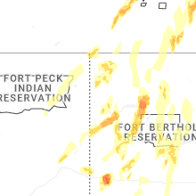
Montana
| Local Time | Report Details |
|---|---|
| 3:24 PM MDT | Half Dollar sized hail reported near Olive, MT, 61 miles SSE of Miles City, MT |
| 3:30 PM MDT | Golf Ball sized hail reported near Broadus, MT, 57.7 miles S of Miles City, MT |
| 3:30 PM MDT | Golf Ball sized hail reported near Broadus, MT, 63.5 miles SSE of Miles City, MT |
| 4:12 PM MDT | Tea Cup sized hail reported near Ekalaka, MT, 71.2 miles SE of Miles City, MT |
| 4:49 PM MDT | Tennis Ball sized hail reported near Alzada, MT, 71.2 miles NE of Gillette, WY |
| 4:58 PM MDT | Tea Cup sized hail reported near Ekalaka, MT, 83.1 miles ESE of Miles City, MT |
| 5:00 PM MDT | Wofm8 mesonet observation sit in roosevelt county MT, 41.5 miles E of Glasgow, MT |
| 5:33 PM MDT | Storm damage reported in yellowstone county MT, 10.7 miles S of Billings, MT |
| 6:15 PM MDT | Asos station kbhk bake in fallon county MT, 76.5 miles E of Miles City, MT |
| 7:00 PM MDT | Mesonet station mtbvr 3.8 ne hodges (mt dot in dawson county MT, 83.7 miles ENE of Miles City, MT |
| 7:00 PM MDT | Corrects previous tstm wnd gst report from 6 s comertown. mtcom mesonet observation sit in sheridan county MT, 54.1 miles NNW of Williston, ND |
| 7:12 PM MDT | Mtcom mesonet observation sit in sheridan county MT, 54.1 miles NNW of Williston, ND |
Missouri
| Local Time | Report Details |
|---|---|
| 5:27 PM CDT | Reports and images of wind damage... including power outages... tree damage... tree uprooted... and buildings with roof damage. damage appears roughly 1-2 blocks wide r in saline county MO, 47.5 miles WNW of Columbia, MO |
| 5:17 AM CDT | Mping report of power poles down or broke in newton county MO, 62 miles WSW of Springfield, MO |
South Dakota
| Local Time | Report Details |
|---|---|
| 4:56 PM MDT | Storm damage reported in crook county WY, 77.1 miles NE of Gillette, WY |
| 5:21 PM MDT | Storm damage reported in harding county SD, 95.8 miles ESE of Miles City, MT |
| 5:25 PM MDT | Storm damage reported in butte county SD, 63.4 miles NW of Rapid City, SD |
| 5:30 PM MDT | Storm damage reported in butte county SD, 66.9 miles NNW of Rapid City, SD |
| 5:40 PM MDT | Ping Pong Ball sized hail reported near Buffalo, SD, 85.4 miles NNW of Rapid City, SD |
| 5:40 PM MDT | Storm damage reported in harding county SD, 109.7 miles ESE of Miles City, MT |
| 5:40 PM MDT | Storm damage reported in harding county SD, 85.4 miles NNW of Rapid City, SD |
| 5:45 PM MDT | Sustained 50-55 mph in harding county SD, 82.2 miles N of Rapid City, SD |
| 5:51 PM MDT | Hen Egg sized hail reported near Redig, SD, 82.2 miles N of Rapid City, SD, easily 2 inch stones with several that appear to be larger. |
| 5:56 PM MDT | Storm damage reported in harding county SD, 124 miles ESE of Miles City, MT |
| 6:00 PM MDT | Tea Cup sized hail reported near Buffalo, SD, 88.3 miles N of Rapid City, SD, this was measured after some melting took place. |
| 6:05 PM MDT | Tennis Ball sized hail reported near Redig, SD, 86.9 miles N of Rapid City, SD, at least tennis ball size. winds only 30-40 mph. |
| 6:19 PM MDT | Storm damage reported in harding county SD, 88.4 miles N of Rapid City, SD |
| 6:28 PM MDT | Storm damage reported in harding county SD, 100.1 miles N of Rapid City, SD |
| 6:29 PM MDT | Storm damage reported in harding county SD, 88.4 miles N of Rapid City, SD |
| 6:29 PM MDT | Ping Pong Ball sized hail reported near Reva, SD, 97.5 miles N of Rapid City, SD, a few stones that size. most were nickle to quarter size stones. |
| 6:31 PM MDT | A lot of hail... covered the groun in harding county SD, 87.6 miles N of Rapid City, SD |
| 6:55 PM MDT | Storm damage reported in perkins county SD, 102.2 miles NNE of Rapid City, SD |
| 9:27 PM MDT | Storm damage reported in jackson county SD, 61.3 miles E of Rapid City, SD |
| 11:14 PM MDT | Mesonet station 293 timber lake (sddot in dewey county SD, 81.3 miles NNW of Pierre, SD |
| 11:15 PM MDT | Mesonet station tims2 timber lake (sd mesonet in dewey county SD, 81.2 miles NNW of Pierre, SD |
| 12:00 AM MDT | Mesonet station grrs2 bullhead 10 s. time estimated by rada in corson county SD, 83.7 miles S of Bismarck, ND |
| 1:04 AM CDT | Mesonet station 50 herreid (sddot in campbell county SD, 73 miles SSE of Bismarck, ND |
| 1:40 AM CDT | Mesonet station 313 selby 5se (sddot in walworth county SD, 71.6 miles W of Aberdeen, SD |
| 1:55 AM CDT | Mesonet station bwls2 bowdle (sd mesonet in edmunds county SD, 57.5 miles W of Aberdeen, SD |
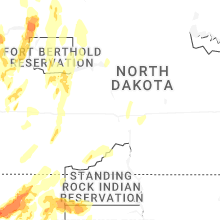
North Dakota
| Local Time | Report Details |
|---|---|
| 5:20 PM MDT | Baseball sized hail reported near Sentinel Butte, ND, 92.4 miles S of Williston, ND, very large hail reported southeast of sentinel butte. largest stones were tennis ball to baseball size. |
| 5:30 PM MDT | Tea Cup sized hail reported near Medora, ND, 88.9 miles S of Williston, ND, relayed through broadcast media. |
| 5:33 PM MDT | Hen Egg sized hail reported near Sentinel Butte, ND, 83.4 miles S of Williston, ND |
| 5:42 PM MDT | Quarter sized hail reported near Medora, ND, 84.9 miles S of Williston, ND, reported at medora campground. hail lasted 6 minutes. |
| 6:03 PM MDT | Ndawn (north dakota agriculture weather network) observatio in bowman county ND, 125 miles ESE of Miles City, MT |
| 6:07 PM MDT | Ping Pong Ball sized hail reported near Belfield, ND, 79.8 miles SSE of Williston, ND, hail lasted 3 minutes. |
| 6:15 PM MDT | Thunderstorm wind gust at the bowman airpor in bowman county ND, 123.1 miles E of Miles City, MT |
| 6:30 PM MDT | Ping Pong Ball sized hail reported near Fairfield, ND, 71.3 miles SSE of Williston, ND |
| 6:39 PM MDT | Ndawn (north dakota agriculture weather network) observatio in slope county ND, 113.3 miles WSW of Bismarck, ND |
| 7:40 PM CDT | Hen Egg sized hail reported near Alexander, ND, 15.7 miles S of Williston, ND, relayed from broadcast media. time estimated from radar. |
| 6:58 PM MDT | 10 meter measured wind gust at ndawn station 5 w new englan in slope county ND, 105.9 miles W of Bismarck, ND |
| 7:04 PM MDT | 10 meter measured wind gust at ndawn station 4 n hallida in dunn county ND, 73.8 miles SW of Minot, ND |
| 8:04 PM CDT | Golf Ball sized hail reported near Williston, ND, 0.4 miles WNW of Williston, ND, in the city of williston. hail ongoing. |
| 7:05 PM MDT | Storm damage reported in hettinger county ND, 88.4 miles WSW of Bismarck, ND |
| 8:06 PM CDT | Ndawn (north dakota agriculture weather network) observatio in divide county ND, 42.7 miles NNW of Williston, ND |
| 7:07 PM MDT | Thunderstorm wind gusts in mot in hettinger county ND, 79.7 miles WSW of Bismarck, ND |
| 7:13 PM MDT | 10 meter measured wind gust at ndawn station 1 n mot in hettinger county ND, 79 miles WSW of Bismarck, ND |
| 7:15 PM MDT | Estimated 70 to 80 mph winds. dime to quarter sized hail accompanied the very strong wind in hettinger county ND, 88.4 miles WSW of Bismarck, ND |
| 8:19 PM CDT | Ndawn (north dakota agriculture weather network) observatio in divide county ND, 56.8 miles N of Williston, ND |
| 8:25 PM CDT | Hen Egg sized hail reported near Arnegard, ND, 24.8 miles SSE of Williston, ND, relayed through social media. time estimated from radar. |
| 7:31 PM MDT | 10 meter measured wind gust at ndawn station elgin 10n in grant county ND, 61.3 miles WSW of Bismarck, ND |
| 7:32 PM MDT | Wind gust measured at the dickinson airpor in stark county ND, 95.9 miles W of Bismarck, ND |
| 8:34 PM CDT | 3 meter measured wind gust at ndawn 7 s crosb in divide county ND, 48 miles NNE of Williston, ND |
| 8:35 PM CDT | 3 meter measured gust at ndawn station 7 s crosb in divide county ND, 48 miles NNE of Williston, ND |
| 7:35 PM MDT | Measured winds using wind senso in stark county ND, 85 miles W of Bismarck, ND |
| 8:38 PM CDT | Ndawn (north dakota agriculture weather network) observatio in morton county ND, 61.7 miles W of Bismarck, ND |
| 7:40 PM MDT | 10 meter measured wind gust at ndawn station 6 nw taylo in stark county ND, 83.1 miles W of Bismarck, ND |
| 8:40 PM CDT | Trained weather spotter reported wind damage in the city of hebron. power out in the city of hebron. numerous branches and trees down... with lots of debris around town in morton county ND, 60.6 miles W of Bismarck, ND |
| 7:45 PM MDT | 10 meter measured wind gust at ndawn 4 s in dunn county ND, 75.7 miles SSE of Williston, ND |
| 8:51 PM CDT | 10 meter measured wind gust at ndawn station noonan 9 in divide county ND, 50.3 miles NNE of Williston, ND |
| 7:51 PM MDT | 3 meter measured wind gust at ndawn station 2 nne hirschvill in dunn county ND, 85.7 miles WNW of Bismarck, ND |
| 8:55 PM CDT | Storm damage reported in morton county ND, 51.3 miles W of Bismarck, ND |
| 9:04 PM CDT | Ndawn (north dakota agriculture weather network) observatio in mckenzie county ND, 29.1 miles SSE of Williston, ND |
| 8:14 PM MDT | Ndawn (north dakota agriculture weather network) observatio in mercer county ND, 54.6 miles NW of Bismarck, ND |
| 8:15 PM MDT | 64 mph wind gust measured 5n of halliday at 10m by ndawn statio in dunn county ND, 73.8 miles SW of Minot, ND |
| 9:20 PM CDT | Relayed through social media. large cottonwood tree blown down over roadwa in mclean county ND, 47.1 miles SSW of Minot, ND |
| 9:20 PM CDT | Private weather statio in oliver county ND, 33.8 miles NW of Bismarck, ND |
| 8:21 PM MDT | Ndawn (north dakota agriculture weather network) observation. em reports of tree damage in the town of haze in mercer county ND, 54.6 miles NW of Bismarck, ND |
| 8:21 PM MDT | Ndawn (north dakota agriculture weather network) observatio in mercer county ND, 63.3 miles SSW of Minot, ND |
| 8:22 PM MDT | 79mph 10m measured gust 3w of haze in mercer county ND, 54.6 miles NW of Bismarck, ND |
| 8:28 PM MDT | Ndawn (north dakota agriculture weather network) observatio in mercer county ND, 54.2 miles SSW of Minot, ND |
| 8:35 PM MDT | Power out in the city of dickinson... with multiple power lines down and a report of at least one tree on a hous in stark county ND, 95.5 miles W of Bismarck, ND |
| 9:44 PM CDT | 10 meter measured wind gust at ndawn station 13 miles northwest of garriso in mclean county ND, 40.5 miles SSW of Minot, ND |
| 9:49 PM CDT | 93mph measured gust at 10m at ndawn... 13nw garriso in mclean county ND, 40.5 miles SSW of Minot, ND |
| 9:50 PM CDT | 98mph gust at 10m... ndawn 13nw garriso in mclean county ND, 40.5 miles SSW of Minot, ND |
| 9:50 PM CDT | Measured wind gust at private weather statio in mclean county ND, 41 miles SSE of Minot, ND |
| 9:52 PM CDT | 86mph 10m measured at ndawn 3 n ma in ward county ND, 25.3 miles S of Minot, ND |
| 9:57 PM CDT | Measured wind gust at nddot station. time estimated from rada in mclean county ND, 36.3 miles NNW of Bismarck, ND |
| 10:06 PM CDT | Asos station kbis bismarck airpor in burleigh county ND, 2.8 miles SSE of Bismarck, ND |
| 10:06 PM CDT | 10 meter measured wind gust at ndawn station sawyer 7 in ward county ND, 20.1 miles SSE of Minot, ND |
| 10:26 PM CDT | Measured 10 meter wind gust at skogmo 3 in sheridan county ND, 52.4 miles SE of Minot, ND |
| 10:27 PM CDT | Awos station k1an 2 wnw balfou in mchenry county ND, 37.9 miles ESE of Minot, ND |
| 10:32 PM CDT | 10 meter measured wind gust at ndawn station wing 8 in burleigh county ND, 38.5 miles NNE of Bismarck, ND |
| 10:53 PM CDT | Measured wind gust at private weather statio in bottineau county ND, 44.3 miles NE of Minot, ND |
| 11:15 PM CDT | Bottineau awos gust to 75 mp in bottineau county ND, 57.4 miles NE of Minot, ND |
| 1:10 AM CDT | Mesonet station 329519 5 w wishek (ndawn in mcintosh county ND, 64.9 miles SE of Bismarck, ND |
| 1:25 AM CDT | Ndawn station wind gust to 59 mph and lasted 5 to 10 minute in logan county ND, 70 miles ESE of Bismarck, ND |
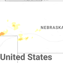
Nebraska
| Local Time | Report Details |
|---|---|
| 6:21 PM MDT | 62 mph gust recorded at kaia awo in box butte county NE, 46.9 miles ENE of Scottsbluff, NE |
| 6:30 PM MDT | Personal weather statio in sheridan county NE, 52.5 miles ENE of Scottsbluff, NE |
| 8:04 PM MDT | Personal weather statio in cheyenne county NE, 57.8 miles SSE of Scottsbluff, NE |
| 8:07 PM MDT | Personal weather station reported gust of 78.1 mp in cheyenne county NE, 61.1 miles SSE of Scottsbluff, NE |
| 8:28 PM MDT | Personal weather statio in cheyenne county NE, 49.3 miles SE of Scottsbluff, NE |
Oklahoma
| Local Time | Report Details |
|---|---|
| 6:20 AM CDT | Storm damage reported in ottawa county OK, 68.6 miles ENE of Tulsa, OK |
| 6:29 AM CDT | Measured gust on the south side of afton in the 60 to 70 mph rang in ottawa county OK, 68.6 miles ENE of Tulsa, OK |
Connect with Interactive Hail Maps