

Hail Map for Friday, August 28, 2015

Number of Impacted Households on 8/28/2015
0
Impacted by 1" or Larger Hail
0
Impacted by 1.75" or Larger Hail
0
Impacted by 2.5" or Larger Hail
Square Miles of Populated Area Impacted on 8/28/2015
0
Impacted by 1" or Larger Hail
0
Impacted by 1.75" or Larger Hail
0
Impacted by 2.5" or Larger Hail

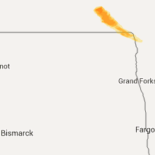


Cities Most Affected by Hail Storms of 8/28/2015
| Hail Size | Demographics of Zip Codes Affected | ||||||
|---|---|---|---|---|---|---|---|
| City | Count | Average | Largest | Pop Density | House Value | Income | Age |
| Pembina, ND | 3 | 2.42 | 2.75 | 4 | $63k | $50.1k | 43.1 |
| Saint Vincent, MN | 2 | 1.88 | 2.00 | 2 | $26k | $36.3k | 50.5 |
| Neche, ND | 1 | 1.75 | 1.75 | 4 | $42k | $41.4k | 40.1 |
Hail and Wind Damage Spotted on 8/28/2015
Filter by Report Type:Hail ReportsWind Reports
North Dakota
| Local Time | Report Details |
|---|---|
| 8:00 AM CDT | Baseball sized hail reported near Pembina, ND, 68 miles W of Roseau, MN |
| 8:58 AM CDT | Ping Pong Ball sized hail reported near Pembina, ND, 68.9 miles W of Roseau, MN, hail just alittle smaller than golf balls was reported. |
| 9:00 AM CDT | Baseball sized hail reported near Pembina, ND, 68 miles W of Roseau, MN |
| 9:06 AM CDT | Golf Ball sized hail reported near Neche, ND, 77.6 miles W of Roseau, MN, large hail but no wind. |
| 9:18 AM CDT | Golf Ball sized hail reported near Pembina, ND, 68 miles W of Roseau, MN, some gusts of wind. |
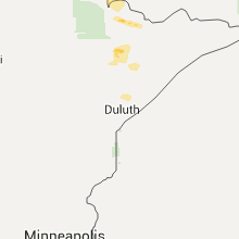
Minnesota
| Local Time | Report Details |
|---|---|
| 9:05 AM CDT | Hen Egg sized hail reported near Saint Vincent, MN, 66.7 miles W of Roseau, MN |
| 9:07 AM CDT | Golf Ball sized hail reported near Saint Vincent, MN, 64.7 miles W of Roseau, MN |
| 9:25 AM CDT | Quarter sized hail reported near Hallock, MN, 55.7 miles W of Roseau, MN |
| 1:55 AM CDT | Trees down near highway 169 mile marker 269. time estimated from rada in st. louis county MN, 72.1 miles N of Duluth, MN |
| 2:15 AM CDT | Trees down near intersection of highway 21/26 and road 969. time estimated from rada in st. louis county MN, 62.5 miles N of Duluth, MN |
Georgia
| Local Time | Report Details |
|---|---|
| 2:32 PM EDT | Trees down on powerlines in southeast bacon count in bacon county GA, 23.6 miles E of Douglas, GA |
| 5:03 PM EDT | The lowndes county 911 center reported one tree down on a shed near cypress street and chester stree in lowndes county GA, 51.9 miles SSW of Douglas, GA |
| 5:04 PM EDT | Tree down on a power pole near copeland mills road and madison highwa in lowndes county GA, 55 miles SSW of Douglas, GA |
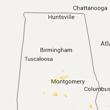
Alabama
| Local Time | Report Details |
|---|---|
| 1:45 PM CDT | Trees and power lines down near abbeville. exact locations not specified in henry county AL, 72.8 miles S of Auburn, AL |
| 1:45 PM CDT | Quarter sized hail reported near Abbeville, AL, 72.8 miles S of Auburn, AL, estimated quarter size hail in the abbeville area |
Florida
| Local Time | Report Details |
|---|---|
| 5:25 PM EDT | Trees down on power lines resulting in power outages in far northeast madison county in madison county FL, 55.7 miles ENE of Tallahassee, FL |
| 5:30 PM EDT | Trees down on power lines in the cherry lake area resulting in power outages in madison county FL, 51.6 miles E of Tallahassee, FL |
| 6:20 PM EDT | Trees down on power lines resulting in power outages near pelis road in madison county FL, 34.1 miles E of Tallahassee, FL |
| 6:20 PM EDT | Trees down on power lines resulting in power outages near nw 85th ave in madison county FL, 34.4 miles E of Tallahassee, FL |
| 6:25 PM EDT | Trees down on power lines resulting in power outages near horace ave in jefferson county FL, 32.3 miles ENE of Tallahassee, FL |
| 6:25 PM EDT | The jefferson county emergency manager reported one tree down along bassett dairy way and hwy 14 in jefferson county FL, 28.7 miles ENE of Tallahassee, FL |
Connect with Interactive Hail Maps