

Hail Map for Thursday, August 29, 2013

Number of Impacted Households on 8/29/2013
0
Impacted by 1" or Larger Hail
0
Impacted by 1.75" or Larger Hail
0
Impacted by 2.5" or Larger Hail
Square Miles of Populated Area Impacted on 8/29/2013
0
Impacted by 1" or Larger Hail
0
Impacted by 1.75" or Larger Hail
0
Impacted by 2.5" or Larger Hail


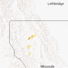


Cities Most Affected by Hail Storms of 8/29/2013
| Hail Size | Demographics of Zip Codes Affected | ||||||
|---|---|---|---|---|---|---|---|
| City | Count | Average | Largest | Pop Density | House Value | Income | Age |
| Hill City, MN | 2 | 1.75 | 1.75 | 8 | $71k | $32.2k | 44.6 |
Hail and Wind Damage Spotted on 8/29/2013
Filter by Report Type:Hail ReportsWind Reports
States Impacted
North Dakota, Minnesota, Montana, Washington, Nevada, Pennsylvania, Utah, California, Arizona, Wyoming, WisconsinNorth Dakota
| Local Time | Report Details |
|---|---|
| 7:05 AM CDT | A few large tree branches down in farm shelter bel in walsh county ND, 65.5 miles E of Devils Lake, ND |
| 7:15 AM CDT | A few large tree branches broken down in a shelter bel in grand forks county ND, 77.6 miles E of Devils Lake, ND |
| 7:15 AM CDT | A couple of large cottonwood trees snapped in shelter bel in walsh county ND, 75.5 miles E of Devils Lake, ND |
Minnesota
| Local Time | Report Details |
|---|---|
| 7:25 AM CDT | Several large tree 3 to 5 inch diameter tree branches broken down in farmyar in marshall county MN, 73.6 miles SW of Roseau, MN |
| 11:30 AM CDT | One 4 inch tree down across highw in itasca county MN, 64 miles NW of Duluth, MN |
| 1:20 PM CDT | Ship algoma progress reported gusts to 60 kts for 3 approximately 3 minutes. measured at 90 ft above water leve in lsz143 county MN, 32.9 miles ENE of Duluth, MN |
| 6:06 PM CDT | Quarter sized hail reported near Remer, MN, 42.1 miles SE of Bemidji, MN |
| 7:03 PM CDT | Golf Ball sized hail reported near Hill City, MN, 66.9 miles ESE of Bemidji, MN, on highway 169. report relayed via social media. time estimated by radar. |
| 7:10 PM CDT | Golf Ball sized hail reported near Hill City, MN, 67.5 miles ESE of Bemidji, MN |
| 7:12 PM CDT | Quarter sized hail reported near Hill City, MN, 70.6 miles ESE of Bemidji, MN |
| 7:59 PM CDT | Several trees down in aitkin county MN, 56.5 miles W of Duluth, MN |
| 8:30 PM CDT | Numerous large trees uprooted and debris on hwy 210. time estimated from rada in aitkin county MN, 68.1 miles W of Duluth, MN |
| 8:45 PM CDT | Several pine trees down. dime sized hail also reporte in aitkin county MN, 63.6 miles WSW of Duluth, MN |
| 9:10 PM CDT | Several trees uproote in aitkin county MN, 63.4 miles WSW of Duluth, MN |
Montana
| Local Time | Report Details |
|---|---|
| 2:30 PM MDT | Storm damage reported in carbon county MT, 62 miles SW of Billings, MT |
| 5:10 PM MDT | Glacier national park official reported several cars damaged from downed trees. estimated winds of 60 mph. tstm wnd dmg duration 30 minutes in flathead county MT, 17.5 miles ENE of Whitefish, MT |
| 7:11 PM MDT | Storm damage reported in toole county MT, 84.7 miles WNW of Havre, MT |
| 7:29 PM MDT | Storm damage reported in toole county MT, 74.5 miles NNW of Great Falls, MT |
| 7:42 PM MDT | Storm damage reported in teton county MT, 49.9 miles WNW of Great Falls, MT |
| 7:59 PM MDT | 58 mph wind gust at pendro in teton county MT, 61.5 miles NW of Great Falls, MT |
| 8:00 PM MDT | Storm damage reported in teton county MT, 35.5 miles NW of Great Falls, MT |
| 8:25 PM MDT | Storm damage reported in liberty county MT, 57.8 miles W of Havre, MT |
| 8:32 PM MDT | Chester courthouse reports gust to 60 mp in liberty county MT, 59.7 miles W of Havre, MT |
| 8:36 PM MDT | Mesonet station chester cw1334 /cw1334/ tstm wnd gst duration 10 minutes in liberty county MT, 59.2 miles W of Havre, MT |
| 8:36 PM MDT | Hanger and airplane were damged in liberty county MT, 59.7 miles W of Havre, MT |
| 9:21 PM MDT | Storm damage reported in chouteau county MT, 42.3 miles SW of Havre, MT |
| 9:22 PM MDT | Storm damage reported in chouteau county MT, 48.5 miles NE of Great Falls, MT |
| 9:36 PM MDT | Storm damage reported in chouteau county MT, 31.9 miles SW of Havre, MT |
| 9:36 PM MDT | Storm damage reported in chouteau county MT, 33 miles SW of Havre, MT |
| 9:40 PM MDT | 71 mph wind gust at havre airport. reported by aso in hill county MT, 4.2 miles WSW of Havre, MT |
| 9:53 PM MDT | Storm damage reported in hill county MT, 4.2 miles WSW of Havre, MT |
| 10:15 PM MDT | Wind gust time estimated off nearby ob in broadwater county MT, 51.5 miles NNW of Bozeman, MT |
| 10:45 PM MDT | Storm damage reported in blaine county MT, 43.5 miles ESE of Havre, MT |
| 11:50 PM MDT | Storm damage reported in phillips county MT, 80.7 miles SE of Havre, MT |
Washington
| Local Time | Report Details |
|---|---|
| 2:08 PM PDT | Kramer raws peak gust occurred between 108 to 208 p in okanogan county WA, 10.4 miles S of Omak, WA |
| 2:25 PM PDT | Wind speed measured with a davis vantage vue. time estimate in okanogan county WA, 0.1 miles WSW of Omak, WA |
| 2:25 PM PDT | Cottonwood trees uprooted and shingles blown off of roof on omak river rd. time estimate in okanogan county WA, 0.1 miles WSW of Omak, WA |
| 2:25 PM PDT | Time estimated. wenatchee world newspaper reported several trees down in omak and okanogan. roof damage to okanogan high schoo in okanogan county WA, 0.1 miles WSW of Omak, WA |
Nevada
| Local Time | Report Details |
|---|---|
| 2:20 PM PDT | Wendover awos reported a wind gust to 62 mp in elko county NV, 90.4 miles E of Elko, NV |
Pennsylvania
| Local Time | Report Details |
|---|---|
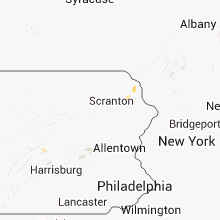
| 5:20 PM EDT | Trees and wires down in wayne county PA, 37.9 miles NE of Scranton, PA |
| 5:30 PM EDT | Quarter sized hail reported near Damascus, PA, 35.3 miles NE of Scranton, PA |
Utah
| Local Time | Report Details |
|---|---|
| 3:28 PM MDT | Wendover awos in tooele county UT, 91.9 miles E of Elko, NV |
| 3:31 PM MDT | Wendover awos in tooele county UT, 91.9 miles E of Elko, NV |
| 3:32 PM MDT | Mp1 sensor via udot in tooele county UT, 91.9 miles E of Elko, NV |
| 3:45 PM MDT | Wendover peak sensor wpk in tooele county UT, 91.9 miles E of Elko, NV |
California
| Local Time | Report Details |
|---|---|
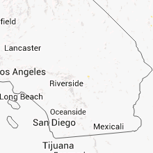
| 3:08 PM PDT | Estimated wind gust up to 70 mph at ucr. very heavy rain with reduced visibilitie in riverside county CA, 49.1 miles E of Los Angeles, CA |
| 3:08 PM PDT | Large tree feel on the rubidoux blvd offramp along highway 6 in riverside county CA, 49.1 miles E of Los Angeles, CA |
Arizona
| Local Time | Report Details |
|---|---|
| 5:45 PM MST | Delayed report...numerous trees up to 14 in diameter downe in yavapai county AZ, 62.8 miles NW of Phoenix, AZ |
| 7:43 PM MST | The london bridge mesonet site in lake havasu city reported a wind gust of 63 mp in mohave county AZ, 0.4 miles SW of Lake Havasu City, AZ |
| 7:50 PM MST | A spotter reported most of the southern half of lake havasu city had lost powe in mohave county AZ, 4.5 miles ENE of Lake Havasu City, AZ |
Wyoming
| Local Time | Report Details |
|---|---|
| 6:49 PM MDT | Sheridan asos reported 61 mph wind gust in sheridan county WY, 79.5 miles WNW of Gillette, WY |
Wisconsin
| Local Time | Report Details |
|---|---|
| 9:20 PM CDT | Tree down in lincoln county WI, 29.2 miles WSW of Rhinelander, WI |
| 10:30 PM CDT | Branches down along highway 52 and county highway in marathon county WI, 48 miles SSW of Rhinelander, WI |
| 10:39 PM CDT | Trees down on road. time estimated in marathon county WI, 42.9 miles SSE of Rhinelander, WI |
| 10:40 PM CDT | Three to four inch diameter branches down in yard on the south side of antigo. reports relayed by wsaw-t in langlade county WI, 36 miles SSE of Rhinelander, WI |
| 11:20 PM CDT | A tree landed on a truc in langlade county WI, 36 miles SSE of Rhinelander, WI |
| 11:48 PM CDT | Trees dow in shawano county WI, 28.6 miles NW of Green Bay, WI |
| 12:15 AM CDT | Trees down in shawano county WI, 22.1 miles NW of Green Bay, WI |
Connect with Interactive Hail Maps