

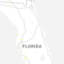
Hail Map for Monday, August 8, 2022

Number of Impacted Households on 8/8/2022
0
Impacted by 1" or Larger Hail
0
Impacted by 1.75" or Larger Hail
0
Impacted by 2.5" or Larger Hail
Square Miles of Populated Area Impacted on 8/8/2022
0
Impacted by 1" or Larger Hail
0
Impacted by 1.75" or Larger Hail
0
Impacted by 2.5" or Larger Hail


Cities Most Affected by Hail Storms of 8/8/2022
| Hail Size | Demographics of Zip Codes Affected | ||||||
|---|---|---|---|---|---|---|---|
| City | Count | Average | Largest | Pop Density | House Value | Income | Age |
Hail and Wind Damage Spotted on 8/8/2022
Filter by Report Type:Hail ReportsWind Reports
States Impacted
Missouri, New York, Arkansas, Florida, Oklahoma, Virginia, Ohio, California, New Hampshire, Vermont, Mississippi, Texas, NevadaMissouri
| Local Time | Report Details |
|---|---|
| 1:12 PM CDT | Corrects previous flash flood report from 1 n alton to thunderstorm wind damage. oregon county dispatch received a report of several trees down and power out on old can in oregon county MO, 64.3 miles S of Salem, MO |
| 3:20 PM CDT | A utility pole was blown over by wind causing power outages in fredericktown. time estimated by report and rainfal in madison county MO, 44.7 miles WNW of Cape Girardeau, MO |
| 3:56 PM CDT | Severe thunderstorm wind gusts blew down a utility pole in caboo in texas county MO, 46.8 miles SW of Salem, MO |
| 5:45 PM CDT | Public report of tree down north of marionvill in lawrence county MO, 22.9 miles WSW of Springfield, MO |
| 5:49 PM CDT | Severe thunderstorm wind gusts downed numerous trees and power line in greene county MO, 12.5 miles WNW of Springfield, MO |
| 5:54 PM CDT | Powerlines and trees down on farm road 11 in greene county MO, 12.8 miles W of Springfield, MO |
| 6:00 PM CDT | Reports of trees down on county road 347 near highway 1 in douglas county MO, 58.1 miles ESE of Springfield, MO |
| 6:05 PM CDT | Public report of tree dow in greene county MO, 10.7 miles SW of Springfield, MO |
| 6:10 PM CDT | Trained spotter reported 60 mph wind gust near mile marker 3 in newton county MO, 65.7 miles WSW of Springfield, MO |
| 6:30 PM CDT | Half Dollar sized hail reported near Branson, MO, 39.5 miles S of Springfield, MO, public report of half dollar size hail at branson landing. |
| 6:30 PM CDT | Report of large tree down at intersection of farm road 97 and 182 in republi in greene county MO, 10.2 miles SW of Springfield, MO |
| 6:32 PM CDT | Quarter sized hail reported near Branson, MO, 39.7 miles S of Springfield, MO, report from mping: quarter (1.00 in.). |
| 6:45 PM CDT | Reports of 4 inch tree limbs blocking main st in nix in christian county MO, 9.6 miles S of Springfield, MO |
| 7:25 PM CDT | Report from mping: 1-inch tree limbs broken; shingles blown of in taney county MO, 39.3 miles S of Springfield, MO |
New York
| Local Time | Report Details |
|---|---|
| 2:36 PM EDT | 200 year old healthy tree down on she in oswego county NY, 34.3 miles NW of Syracuse, NY |
| 3:12 PM EDT | Tree and wires down in west monro in oswego county NY, 16.5 miles NNE of Syracuse, NY |
| 3:28 PM EDT | Tree and wires dow in oswego county NY, 18.5 miles NNE of Syracuse, NY |
| 3:39 PM EDT | 3 telephone poles down... and tree on wires on county route in oswego county NY, 37.4 miles NNE of Syracuse, NY |
| 4:14 PM EDT | Pole and wires down in watso in lewis county NY, 61.1 miles NE of Syracuse, NY |
| 7:34 PM EDT | Tree down in the back yard in the city of buffal in erie county NY, 2.4 miles N of Buffalo, NY |
Arkansas
| Local Time | Report Details |
|---|---|
| 1:45 PM CDT | Some trees and power lines were knocked down along highway 91 just north of egyp in craighead county AR, 71.5 miles NW of Memphis, TN |
| 1:47 PM CDT | A large tree knocked over onto powerlines along napa valley drive on the western side of little rock... a in pulaski county AR, 7.7 miles W of Little Rock, AR |
| 1:49 PM CDT | Large tree knocked down onto a home on west stoney pointe court in western little rock... a in pulaski county AR, 7.2 miles W of Little Rock, AR |
| 2:16 PM CDT | Large tree down across a fence in macon... a in pulaski county AR, 13.2 miles NNE of Little Rock, AR |
| 2:20 PM CDT | Trees and power lines down near the intersection of mlk bypass and central ave in the southern side of hot springs... a in garland county AR, 49 miles WSW of Little Rock, AR |
| 2:21 PM CDT | Multiple trees... tree limbs... and tops of trees snapped in the hatcher road area near sherwood... a in pulaski county AR, 10.2 miles NNE of Little Rock, AR |
| 2:43 PM CDT | Multiple power poles snapped along section line road across the mlk bypass from st. vincent hospital on the southside of hot springs... a in garland county AR, 49.2 miles WSW of Little Rock, AR |
| 3:00 PM CDT | Some tree limbs were blown dow in montgomery county AR, 36.5 miles NNE of Nashville, AR |
Florida
| Local Time | Report Details |
|---|---|
| 2:15 PM CDT | Wind gust of 64 mph over gulf coast state colleg in bay county FL, 39.8 miles ESE of Miramar Beach, FL |
| 5:10 PM EDT | Quarter sized hail reported near Saint Petersburg, FL, 22.5 miles NNW of Bradenton, FL, quarter sized hail reported in kenneth city by a trained spotter. time estimated by radar. |
| 5:28 PM EDT | Tree down on holly roa in lafayette county FL, 81.2 miles WSW of Jacksonville, FL |
| 5:28 PM EDT | Power line down on jasmine roa in lafayette county FL, 82.2 miles WSW of Jacksonville, FL |
| 5:30 PM EDT | Big tree down reported to the 911 call cente in lafayette county FL, 83.5 miles WSW of Jacksonville, FL |
| 5:34 PM EDT | Delayed report: broadcast media shared picture of large tree snapped in rotonda area of charlotte co. several other downed trees reported across the area. time estimate in charlotte county FL, 45.2 miles SSE of Bradenton, FL |
| 5:41 PM EDT | Asos station ksrq sarasota braden in manatee county FL, 6.6 miles S of Bradenton, FL |
| 6:10 PM EDT | Tree down on county road 36 in lafayette county FL, 71.6 miles ESE of Tallahassee, FL |
Oklahoma
| Local Time | Report Details |
|---|---|
| 3:35 PM CDT | Power poles snappe in kingfisher county OK, 36.2 miles NW of Oklahoma City, OK |
| 3:35 PM CDT | Large tree snappe in kingfisher county OK, 36.6 miles NW of Oklahoma City, OK |
| 6:15 PM CDT | Power poles snappe in pottawatomie county OK, 34.3 miles ESE of Oklahoma City, OK |
| 5:07 AM CDT | Report from mping: 3-inch tree limbs broken; power poles broke in pittsburg county OK, 56.9 miles NNE of Atoka, OK |
Virginia
| Local Time | Report Details |
|---|---|
| 5:38 PM EDT | Tree down blocking the roadway near the intersection of chatham road and mountain mist driv in henry county VA, 38.3 miles SSE of Roanoke, VA |
Ohio
| Local Time | Report Details |
|---|---|
| 6:36 PM EDT | Fairport harbor c-man station (faio1) recorded a peak gust of 56 knots from a thunderstor in lez147 county OH, 27.6 miles NE of Cleveland, OH |
| 7:30 PM EDT | Mesonet station loro1 2 nnw lorai in lez145 county OH, 26 miles W of Cleveland, OH |
| 9:13 PM EDT | Tree down on dean d in summit county OH, 35.5 miles S of Cleveland, OH |
California
| Local Time | Report Details |
|---|---|
| 3:45 PM PDT | Corrects previous tstm wnd gst report from 4 sse pine valley. horse sdhgpa mesonet statio in san diego county CA, 39.9 miles E of San Diego, CA |
| 4:08 PM PDT | Barstow fire reported numerous power poles down around barstow from thunderstorm related wind in san bernardino county CA, 63.2 miles NW of Yucca Valley, CA |
| 4:08 PM PDT | Corrects previous report from 2 sse lenwood. barstow fire reported power poles down over the road at aberdeen drive and yucca mesa road in barstow due to thunderstorm r in san bernardino county CA, 54.7 miles NNW of Yucca Valley, CA |
| 5:28 PM PDT | 5 foot oak tree down on both lanes old highway 80 and deoda in san diego county CA, 37.5 miles ENE of San Diego, CA |
New Hampshire
| Local Time | Report Details |
|---|---|
| 7:12 PM EDT | Corrects previous tstm wnd dmg report from 10 ne clarksville. reported by weather spotter... delayed report. media reports on scattered area of storm damage north of pi in coos county NH, 109.1 miles ENE of Burlington, VT |
Vermont
| Local Time | Report Details |
|---|---|
| 7:24 PM EDT | Trees and powerlines down in rutland county VT, 60.3 miles NE of Schenectady, NY |
Mississippi
| Local Time | Report Details |
|---|---|
| 6:38 PM CDT | Multiple powerlines dow in simpson county MS, 35 miles S of Jackson, MS |
| 7:34 PM CDT | A tree was reported down on natchez trace pkw in claiborne county MS, 42.9 miles WSW of Jackson, MS |
| 7:50 PM CDT | One tree downed along natchez trace parkway in ne claiborne count in claiborne county MS, 36.1 miles WSW of Jackson, MS |
Texas
| Local Time | Report Details |
|---|---|
| 6:49 PM CDT | A landspout caused damage to an extended carport. in addition... a couple tractor trailers were pushed 30 to 40 feet from their original location and a roof was partial in moore county TX, 46.8 miles N of Amarillo, TX |
Nevada
| Local Time | Report Details |
|---|---|
| 6:20 PM PDT | East carson nv energy mesonet site recorded a 68 mph wind gust from the eas in carson city county NV, 24.2 miles SSE of Reno, NV |
Connect with Interactive Hail Maps