

Hail Map for Sunday, July 18, 2021

Number of Impacted Households on 7/18/2021
0
Impacted by 1" or Larger Hail
0
Impacted by 1.75" or Larger Hail
0
Impacted by 2.5" or Larger Hail
Square Miles of Populated Area Impacted on 7/18/2021
0
Impacted by 1" or Larger Hail
0
Impacted by 1.75" or Larger Hail
0
Impacted by 2.5" or Larger Hail


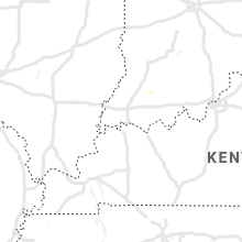


Cities Most Affected by Hail Storms of 7/18/2021
| Hail Size | Demographics of Zip Codes Affected | ||||||
|---|---|---|---|---|---|---|---|
| City | Count | Average | Largest | Pop Density | House Value | Income | Age |
| Goodland, KS | 3 | 1.83 | 2.00 | 9 | $65k | $33.1k | 41.5 |
Hail and Wind Damage Spotted on 7/18/2021
Filter by Report Type:Hail ReportsWind Reports
States Impacted
Nebraska, Kansas, Georgia, South Carolina, North Carolina, Virginia, Florida, Colorado, Oklahoma, Utah, Arizona, Texas, NevadaNebraska
| Local Time | Report Details |
|---|---|
| 10:20 AM CDT | Half Dollar sized hail reported near Lebanon, NE, 60.7 miles NE of Colby, KS, relayed quarter to half dollar size hail. |
Kansas
| Local Time | Report Details |
|---|---|
| 11:00 AM CDT | Spotter reported damaging winds estimated 70 mph. winds were strong enough to blow steel lawn furniture 6-7 ft... snapped an 8 ft long tree branch and threw it across t in decatur county KS, 50.7 miles ENE of Colby, KS |
| 12:20 PM CDT | Quarter sized hail reported near Hays, KS, 0.9 miles NE of Hays, KS, public report made via wfo goodland. |
| 12:20 PM CDT | Quarter sized hail reported near Hays, KS, 2.4 miles WNW of Hays, KS, report from mping: quarter (1.00 in.). |
| 12:20 PM CDT | Up to 5 semi trucks were blown over along i-70 between mile markers 157 and 154. time is estimated by rada in ellis county KS, 5 miles NW of Hays, KS |
| 12:21 PM CDT | Report from mping: 1-inch tree limbs broken; shingles blown of in ellis county KS, 2.4 miles WNW of Hays, KS |
| 12:27 PM CDT | Quarter sized hail reported near Hays, KS, 2.4 miles WNW of Hays, KS, report from mping: quarter (1.00 in.). |
| 11:45 AM MDT | Quarter sized hail reported near Kanorado, KS, 53.4 miles W of Colby, KS, spotter reported ongoing pea to quarter sized hail with a duration as of 1215 pm mt of 30 minutes. |
| 12:20 PM MDT | Quarter sized hail reported near Kanorado, KS, 53.4 miles W of Colby, KS, reported via social media. |
| 12:48 PM MDT | Quarter sized hail reported near Goodland, KS, 36.3 miles W of Colby, KS |
| 12:51 PM MDT | Half Dollar sized hail reported near Goodland, KS, 36.2 miles W of Colby, KS |
| 12:52 PM MDT | Hen Egg sized hail reported near Goodland, KS, 35.8 miles W of Colby, KS, off duty employee reports 2 inch hail. |
| 12:52 PM MDT | Half Dollar sized hail reported near Goodland, KS, 35.8 miles W of Colby, KS, report from mping: half dollar (1.25 in.). |
| 12:53 PM MDT | Golf Ball sized hail reported near Goodland, KS, 35.8 miles W of Colby, KS |
| 12:55 PM MDT | Half Dollar sized hail reported near Goodland, KS, 36.2 miles W of Colby, KS |
| 12:59 PM MDT | Half Dollar sized hail reported near Goodland, KS, 35.2 miles W of Colby, KS, report from mping: half dollar (1.25 in.). |
| 1:08 PM MDT | Golf Ball sized hail reported near Goodland, KS, 35.8 miles W of Colby, KS, facebook video showed golf ball size hail falling. |
| 2:15 PM CDT | Storm damage reported in pawnee county KS, 44 miles SSE of Hays, KS |
| 1:17 PM MDT | Ping Pong Ball sized hail reported near Goodland, KS, 35.7 miles W of Colby, KS, measured 1.6 inch hail with photo. |
| 2:10 PM MDT | Quarter sized hail reported near Tribune, KS, 69.4 miles WNW of Garden City, KS, caller reported dime to sporadic quarter sized hail. |
| 2:30 PM MDT | Delayed report. caller reported estimated 70 mph winds that caused tree limbs to be snapped off trees on the property. time estimated by rada in wallace county KS, 63.3 miles SW of Colby, KS |
| 4:10 PM CDT | Half Dollar sized hail reported near Saint Francis, KS, 43.4 miles NW of Colby, KS, hail ranged from half inch to half dollar in size. |
| 4:25 PM CDT | Quarter sized hail reported near Saint Francis, KS, 41.9 miles WNW of Colby, KS, spotter reported hail ranging from pea to quarter sized. |
Georgia
| Local Time | Report Details |
|---|---|
| 12:11 PM EDT | The screven county warning point reported a power line down along antioch roa in screven county GA, 45.6 miles SSE of Augusta, GA |
| 12:25 PM EDT | The screven county warning point reported a tree down near the intersection of highway 301 and highway 2 in screven county GA, 49.9 miles SSE of Augusta, GA |
| 5:10 PM EDT | Mesonet station ga355 us 341 at sr 38. wayne county 911 reported numerous trees down in jesup and just outside of city limit in wayne county GA, 56.6 miles SW of Savannah, GA |
| 6:20 PM EDT | Tree reported down at old monticello rd and plantation dr. powerlines also were reported down in the are in thomas county GA, 32.4 miles NE of Tallahassee, FL |
| 6:20 PM EDT | Tree reported down at magnolia rd and train tracks. powerlines were also reported down in the are in thomas county GA, 29.5 miles NE of Tallahassee, FL |
South Carolina
| Local Time | Report Details |
|---|---|
| 2:12 PM EDT | Sc highway patrol reported a tree down at the intersection of bethel road and low country highway. time estimated by rada in colleton county SC, 52.2 miles WSW of Charleston, SC |
| 2:12 PM EDT | Sc highway patrol reported a tree down at the intersection of bells highway and low country highway. time estimated by rada in colleton county SC, 50.8 miles WSW of Charleston, SC |
| 2:34 PM EDT | Sc highway patrol reported a tree down at the intersection of mccleod road and mt carmel road. time estimated by rada in colleton county SC, 41.6 miles WSW of Charleston, SC |
| 2:54 PM EDT | Sc highway patrol reported a tree down at the intersection of charleston highway and titen road. another tree was reported down roughly a mile away... at the intersecti in colleton county SC, 39.1 miles SW of Charleston, SC |
| 3:25 PM EDT | Sc highway patrol reported a downed tree blocking portions of i-95 at mile marker 126.5. downed tree confirmed via dot highway camera. time estimated by rada in clarendon county SC, 41.9 miles NNW of Charleston, SC |
| 4:05 PM EDT | Large pine limbs blown down during thunderstorm in florence county SC, 50.5 miles N of Charleston, SC |
| 5:00 PM EDT | Tree in roadway interstection of us 76 and hassie r in marion county SC, 74.3 miles NNE of Charleston, SC |
| 5:00 PM EDT | Few trees down on powerlines near musc health(medical university of south carolina) in florence in florence county SC, 68.1 miles NNE of Charleston, SC |
| 8:25 PM EDT | Sc highway patrol reports trees down at pine log road and beech island avenue... and pine log road and wise drive. time estimated by rada in aiken county SC, 7.5 miles ESE of Augusta, GA |
| 8:35 PM EDT | Sc highway patrol reports tree in roadway at silver bluff road and sc-302. time estimated by rada in aiken county SC, 14.4 miles ENE of Augusta, GA |
North Carolina
| Local Time | Report Details |
|---|---|
| 2:45 PM EDT | Quarter sized hail reported near Leland, NC, 12.8 miles WNW of Wilmington, NC, quarter size hail reported in town of northwest |
Virginia
| Local Time | Report Details |
|---|---|
| 3:57 PM EDT | Tree down on stella roa in patrick county VA, 45.6 miles S of Roanoke, VA |
| 7:15 PM EDT | Trees down across courthouse road and traffic road. time estimated by rada in lunenburg county VA, 57.9 miles SW of Richmond, VA |
| 7:52 PM EDT | Trees and power lines down near monroe rd and mount horeb roa in southampton county VA, 52.4 miles W of Virginia Beach, VA |
Florida
| Local Time | Report Details |
|---|---|
| 4:15 PM EDT | Jea utilities responeded to severe thunerstorm wind damage to infrastrure between tarpon drive and peeler road. the time of damage was based on rada in duval county FL, 3.9 miles ENE of Jacksonville, FL |
Colorado
| Local Time | Report Details |
|---|---|
| 2:30 PM MDT | Quarter sized hail reported near Holly, CO, 71.4 miles WNW of Garden City, KS, trained spotter reported quarter-size hail with severe thunderstorm that moved through earlier this afternoon. |
| 3:29 PM MDT | Report from mping: 1-inch tree limbs broken; shingles blown of in prowers county CO, 68.3 miles W of Garden City, KS |
Oklahoma
| Local Time | Report Details |
|---|---|
| 3:39 PM CDT | 4 - 6" tree limbs down in beave in beaver county OK, 67.5 miles WNW of Woodward, OK |
| 4:40 PM CDT | Storm damage reported in woods county OK, 43.7 miles NNE of Woodward, OK |
| 7:10 PM CDT | Quarter sized hail reported near Oklahoma City, OK, 8.6 miles S of Oklahoma City, OK, located at 119th street and penn. |
Utah
| Local Time | Report Details |
|---|---|
| 2:42 PM MDT | Vernon raw in tooele county UT, 53.7 miles SSW of Salt Lake City, UT |
| 2:45 PM MDT | Vernon hill weather statio in tooele county UT, 50.6 miles SSW of Salt Lake City, UT |
| 6:25 PM MDT | English village weather statio in tooele county UT, 57.5 miles SW of Salt Lake City, UT |
| 6:45 PM MDT | Romeo and centerline weather statio in tooele county UT, 79.1 miles WSW of Salt Lake City, UT |
Arizona
| Local Time | Report Details |
|---|---|
| 5:00 PM MST | Gust to 66 mph at temple bar. 48g66. relative humidity increased 15 percent and temperature decreased by 9f in 15 minute in mohave county AZ, 46.9 miles ESE of Las Vegas, NV |
Texas
| Local Time | Report Details |
|---|---|
| 7:15 PM CDT | 4 telephone poles down 5.8 ene of hamlin on highway 9 in jones county TX, 36.5 miles NNW of Abilene, TX |
| 8:20 PM CDT | Storm damage reported in collingsworth county TX, 29 miles N of Childress, TX |
Nevada
| Local Time | Report Details |
|---|---|
| 5:50 PM PDT | Park service reports a house boat rescue just outside callville bay. boat was pushed up on to shoreline due to strong thunderstorm winds. incident time 5:45p in clark county NV, 23.7 miles E of Las Vegas, NV |
Connect with Interactive Hail Maps