

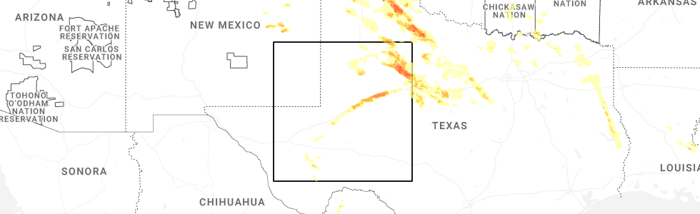
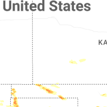
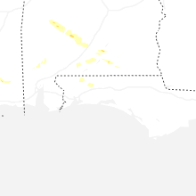
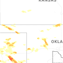
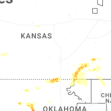
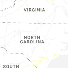
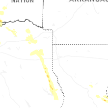
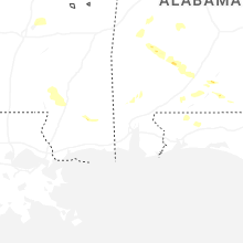
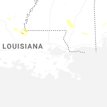
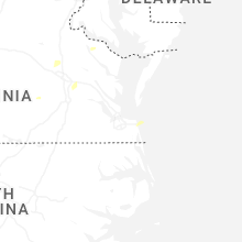
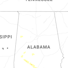
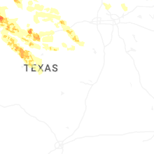
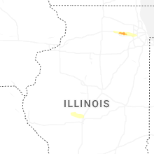
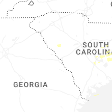
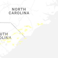
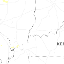
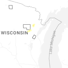
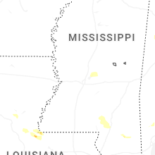
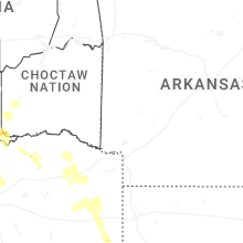
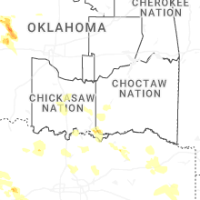
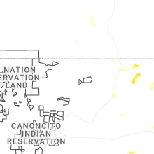
Hail Map for Sunday, June 8, 2025
Number of Impacted Households on 6/8/2025
0
Impacted by 1" or Larger Hail
0
Impacted by 1.75" or Larger Hail
0
Impacted by 2.5" or Larger Hail
Square Miles of Populated Area Impacted on 6/8/2025
0
Impacted by 1" or Larger Hail
0
Impacted by 1.75" or Larger Hail
0
Impacted by 2.5" or Larger Hail


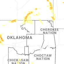
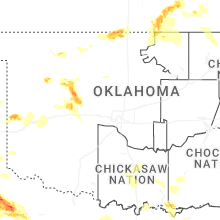

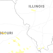

Cities Most Affected by Hail Storms of 6/8/2025
| Hail Size | Demographics of Zip Codes Affected | ||||||
|---|---|---|---|---|---|---|---|
| City | Count | Average | Largest | Pop Density | House Value | Income | Age |
| Batavia, IL | 9 | 2.14 | 2.50 | 1119 | $205k | $70.2k | 40.5 |
| Claude, TX | 3 | 3.17 | 4.25 | 1 | $60k | $38.0k | 45.4 |
| Spur, TX | 4 | 2.00 | 2.50 | 4 | $22k | $27.8k | 40.6 |
| Paducah, TX | 3 | 2.17 | 2.50 | 0 | $26k | $24.6k | 46.5 |
| Clarendon, TX | 3 | 1.92 | 2.00 | 1 | $51k | $29.3k | 42.4 |
| Baird, TX | 2 | 1.75 | 1.75 | 7 | $41k | $30.3k | 46.4 |
| Big Spring, TX | 2 | 1.75 | 1.75 | 32 | $39k | $30.5k | 38.4 |
| Midland, TX | 2 | 1.75 | 1.75 | 69 | $82k | $40.8k | 34.6 |
| Stinnett, TX | 2 | 1.75 | 1.75 | 1 | $40k | $33.7k | 38.0 |
| Rotan, TX | 1 | 2.75 | 2.75 | 5 | $31k | $24.2k | 45.7 |
| Coahoma, TX | 1 | 2.50 | 2.50 | 2 | $39k | $38.9k | 42.1 |
| Abilene, TX | 1 | 2.50 | 2.50 | 393 | $98k | $46.7k | 35.1 |
| Dalhart, TX | 1 | 2.25 | 2.25 | 5 | $63k | $33.1k | 36.5 |
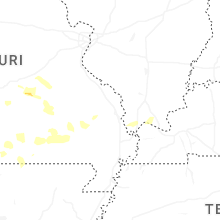
| Bronson, KS | 1 | 2.00 | 2.00 | 5 | $22k | $26.8k | 44.3 |
| Fort Scott, KS | 1 | 2.00 | 2.00 | 42 | $48k | $31.0k | 37.2 |
| Girard, TX | 1 | 2.00 | 2.00 | 1 | $41k | $21.9k | 51.0 |
| Clinton, MO | 1 | 2.00 | 2.00 | 53 | $72k | $30.6k | 44.1 |
| Woodson, TX | 1 | 1.75 | 1.75 | 2 | $24k | $27.1k | 46.7 |
| Howard, KS | 1 | 1.75 | 1.75 | 3 | $27k | $28.6k | 50.1 |
| Childress, TX | 1 | 1.75 | 1.75 | 7 | $45k | $27.5k | 33.8 |
| Longdale, OK | 1 | 1.75 | 1.75 | 8 | $32k | $23.2k | 47.9 |
| Texline, TX | 1 | 1.75 | 1.75 | 1 | $44k | $33.6k | 33.2 |
| Clyde, TX | 1 | 1.75 | 1.75 | 27 | $57k | $34.1k | 40.7 |
| Westbrook, TX | 1 | 1.75 | 1.75 | 0 | $27k | $28.4k | 36.2 |
| Montrose, MO | 1 | 1.75 | 1.75 | 9 | $43k | $31.1k | 46.8 |
| Elburn, IL | 1 | 1.75 | 1.75 | 198 | $221k | $79.2k | 39.4 |
| Eldon, MO | 1 | 1.75 | 1.75 | 81 | $69k | $30.6k | 40.4 |
| Center, TX | 1 | 1.75 | 1.75 | 39 | $58k | $29.5k | 36.2 |
| Jayton, TX | 1 | 1.75 | 1.75 | 0 | $24k | $35.5k | 46.8 |
| Cheyenne, OK | 1 | 1.75 | 1.75 | 3 | $52k | $28.7k | 39.7 |
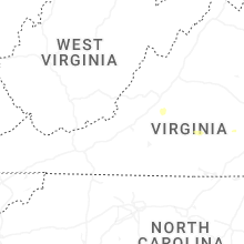
Hail and Wind Damage Spotted on 6/8/2025
Filter by Report Type:Hail ReportsWind Reports
States Impacted
Virginia, Texas, South Carolina, Kansas, North Carolina, Oklahoma, Illinois, Louisiana, Alabama, Missouri, Wisconsin, Michigan, New Mexico, Indiana, ColoradoVirginia
| Local Time | Report Details |
|---|---|
| 9:01 AM EDT | Tree knocked down... blocking 75 percent of the road at benefit road and s battlefield blvd. time estimated from rada in city of chesapeake county VA, 12 miles SW of Virginia Beach, VA |
| 2:38 PM EDT | Tree knocked down near the intersection of harts landing rd and horners mill rd . time estimated from rada in westmoreland county VA, 57.1 miles NE of Richmond, VA |
| 4:36 PM EDT | Tree knocked down along full rack dr. time estimated from rada in chesterfield county VA, 7.1 miles S of Richmond, VA |
| 4:55 PM EDT | Tree down... blocking entire roa in campbell county VA, 49.7 miles E of Roanoke, VA |
| 5:23 PM EDT | Large limbs down. measured wind gust 31 mp in campbell county VA, 61.4 miles E of Roanoke, VA |
| 5:24 PM EDT | Steeple blew off providence baptist church (reported by tv meteorologist - wset/abc1 in charlotte county VA, 61.5 miles E of Roanoke, VA |
| 5:25 PM EDT | Scattered wind damage... large limbs and trees down... across the northern part of the county from 5:25-5:45p in charlotte county VA, 63.1 miles E of Roanoke, VA |
| 5:45 PM EDT | Corrects previous tstm wnd dmg report from 2 se briery creek lake. tree downed on worsham road near meherrin rd. time is radar-estimate in prince edward county VA, 48.2 miles WSW of Richmond, VA |
| 5:55 PM EDT | Quarter sized hail reported near Emporia, VA, 49.4 miles S of Richmond, VA |
| 6:00 PM EDT | Called the 911 center... and the dispatcher mentioned a lot of trees were down across the count in charlotte county VA, 62.5 miles WSW of Richmond, VA |
| 6:15 PM EDT | Trees down blocking several roads. county dispatch reporting trees down and roads blocked in several locations... from 6:00 pm to 6:30p in charlotte county VA, 68.3 miles SW of Richmond, VA |
| 7:23 PM EDT | Tree down in the roadway. radar estimated tim in amelia county VA, 24.2 miles SW of Richmond, VA |
| 7:25 PM EDT | Tree down across little patrick road. time estimated from rada in amelia county VA, 22.6 miles SW of Richmond, VA |
| 7:29 PM EDT | Large tree fell onto powerlines at the 1800 block of north mountain rd in shenandoah county VA, 59.9 miles ESE of Elkins, WV |
| 7:35 PM EDT | Corrects time of previous tstm wnd dmg report from 3 n denaro. tree down in the roadway. radar estimated tim in amelia county VA, 24.2 miles SW of Richmond, VA |
| 7:35 PM EDT | Corrects time of previous tstm wnd dmg report from 3 ne denaro. tree down across little patrick road. time estimated from rada in amelia county VA, 22.6 miles SW of Richmond, VA |
| 8:08 PM EDT | Tree blocking roadway. radar estimated tim in hanover county VA, 25.3 miles N of Richmond, VA |
| 8:50 PM EDT | Multiple trees snapped along with power lines down near the intersection of oak grove lane and nelsons bridge rd. call came in at 9:17 according to county officials. in king william county VA, 26.9 miles NE of Richmond, VA |
Texas
| Local Time | Report Details |
|---|---|
| 8:07 AM CDT | Mesonet station 113 5w rotan rotan/fisher count in fisher county TX, 54.1 miles WNW of Abilene, TX |
| 8:10 AM CDT | Baseball sized hail reported near Rotan, TX, 46.3 miles NW of Abilene, TX, report from mping: baseball (2.75 in.). |
| 8:16 AM CDT | Quarter sized hail reported near Rotan, TX, 50.6 miles NW of Abilene, TX, report from mping: quarter (1.00 in.). |
| 8:31 AM CDT | Ping Pong Ball sized hail reported near Mc Caulley, TX, 37.6 miles WNW of Abilene, TX |
| 11:11 AM CDT | Storm damage reported in parker county TX, 58.5 miles W of Dallas, TX |
| 11:58 AM CDT | Social media report of 68mph sustained winds recorded via personal weather statio in upshur county TX, 71.1 miles WNW of Shreveport, LA |
| 2:41 PM CDT | Half Dollar sized hail reported near Memphis, TX, 20.7 miles NW of Childress, TX, report from mping: half dollar (1.25 in.). |
| 2:46 PM CDT | Quarter sized hail reported near Memphis, TX, 16.7 miles NW of Childress, TX, report from mping: quarter (1.00 in.). |
| 3:15 PM CDT | Half Dollar sized hail reported near Claude, TX, 17.9 miles ESE of Amarillo, TX |
| 3:38 PM CDT | Quarter sized hail reported near Claude, TX, 29.8 miles ESE of Amarillo, TX, report from mping: quarter (1.00 in.). |
| 3:40 PM CDT | Quarter sized hail reported near Claude, TX, 30.3 miles ESE of Amarillo, TX, report from mping: quarter (1.00 in.). |
| 3:42 PM CDT | Golf Ball sized hail reported near Claude, TX, 31.1 miles ESE of Amarillo, TX |
| 3:51 PM CDT | Ping Pong Ball sized hail reported near Claude, TX, 30.1 miles ESE of Amarillo, TX |
| 3:51 PM CDT | 911 call center received reports of several trees and powerlines down in the vicinity of longview height in harrison county TX, 55 miles W of Shreveport, LA |
| 3:52 PM CDT | Golf Ball sized hail reported near Texline, TX, 91 miles NNE of Tucumcari, NM |
| 4:05 PM CDT | Quarter sized hail reported near Skellytown, TX, 44.6 miles NE of Amarillo, TX, report from mping: quarter (1.00 in.). |
| 4:11 PM CDT | Tea Cup sized hail reported near Claude, TX, 31.8 miles ESE of Amarillo, TX, report from mping: baseball++ (3.50 in.). |
| 4:16 PM CDT | Ping Pong Ball sized hail reported near Stinnett, TX, 47.7 miles NNE of Amarillo, TX |
| 4:16 PM CDT | Grapefruit sized hail reported near Claude, TX, 31.8 miles ESE of Amarillo, TX, report from mping: grapefruit+ (4.25 in.). |
| 4:23 PM CDT | Ping Pong Ball sized hail reported near Stinnett, TX, 47.7 miles NNE of Amarillo, TX |
| 4:30 PM CDT | Public report on social media of a large tree down at a playground in tatu in rusk county TX, 47.1 miles WSW of Shreveport, LA |
| 4:40 PM CDT | Mesonet gusted to 65 mph at 1640cdt and continued to gust above 58 mph until 1646cdt. peak gust of 83 mph occurred at 1642cd in armstrong county TX, 48.5 miles ESE of Amarillo, TX |
| 4:49 PM CDT | Golf Ball sized hail reported near Stinnett, TX, 47.7 miles NNE of Amarillo, TX |
| 4:54 PM CDT | Half Dollar sized hail reported near Carthage, TX, 48.2 miles SW of Shreveport, LA, report of half dollar size hail near the intersection of county road 106 and county road 103. |
| 5:07 PM CDT | Hen Egg sized hail reported near Dalhart, TX, 73 miles NW of Amarillo, TX, report from mping: hen egg+ (2.25 in.). |
| 5:09 PM CDT | Nssl team measured a 90 mph wind gust with their mobile mesonet. the winds overturned a center pivot near this locatio in hall county TX, 43.8 miles WNW of Childress, TX |
| 5:10 PM CDT | Hen Egg sized hail reported near Clarendon, TX, 43.8 miles WNW of Childress, TX, 2.2 inch hail measured by icechip. time of hail is estimated. |
| 5:13 PM CDT | Golf Ball sized hail reported near Clarendon, TX, 43.2 miles WNW of Childress, TX, report from mping: golf ball (1.75 in.). |
| 5:19 PM CDT | Hen Egg sized hail reported near Clarendon, TX, 43.8 miles WNW of Childress, TX, report from mping: hen egg (2.00 in.). |
| 5:21 PM CDT | West texas mesonet. also measured a gust to 59 mph at 5:22 p in hall county TX, 37.4 miles WNW of Childress, TX |
| 5:24 PM CDT | Quarter sized hail reported near Denton, TX, 31.4 miles NNW of Dallas, TX, report from mping. quarter size hail. |
| 5:25 PM CDT | Quarter sized hail reported near Denton, TX, 32.2 miles NNW of Dallas, TX, report from mping. quarter size hail. |
| 5:25 PM CDT | Half Dollar sized hail reported near Borger, TX, 35.9 miles NNE of Amarillo, TX |
| 5:25 PM CDT | Quarter sized hail reported near Borger, TX, 40.2 miles NE of Amarillo, TX, report from icechip research team. |
| 5:26 PM CDT | Quarter sized hail reported near Borger, TX, 35.9 miles NNE of Amarillo, TX, report from mping: quarter (1.00 in.). |
| 5:44 PM CDT | Quarter sized hail reported near Lake Dallas, TX, 26.9 miles NNW of Dallas, TX, quarter size hail in lake dallas via amateur radio. |
| 5:46 PM CDT | Quarter sized hail reported near , , 45.9 miles NNE of Amarillo, TX, report from mping: quarter (1.00 in.). |
| 5:50 PM CDT | Quarter sized hail reported near Stephenville, TX, 84.5 miles WSW of Dallas, TX, quarter size hail reported in morgan mill by fd. |
| 5:51 PM CDT | Measured by the west texas mesonet. another gust to 60 mph was measured at 5:53 p in motley county TX, 24.8 miles WSW of Childress, TX |
| 5:53 PM CDT | Quarter sized hail reported near Lipan, TX, 76.4 miles WSW of Dallas, TX, images from social media of hail measuring three quarter of an inch to one inch south of lipan. |
| 5:58 PM CDT | Golf Ball sized hail reported near Center, TX, 40.7 miles NE of Lufkin, TX, social media report of golf ball size hail near hwy 7. |
| 6:00 PM CDT | Steeple of church blown off. time of damage estimate in cottle county TX, 19 miles SW of Childress, TX |
| 6:00 PM CDT | Storm damage reported in ward county TX, 55.4 miles WSW of Odessa, TX |
| 6:00 PM CDT | Quarter sized hail reported near Panhandle, TX, 27.5 miles ENE of Amarillo, TX |
| 6:00 PM CDT | Power pole bent over the roadway. lines still attached... hanging at about 6 to 7 feet above the roadway. time is when the report came in. damage may have occurred earl in motley county TX, 20.3 miles WSW of Childress, TX |
| 6:04 PM CDT | Golf Ball sized hail reported near Stinnett, TX, 48.3 miles NNE of Amarillo, TX, report from mping: golf ball (1.75 in.). |
| 6:10 PM CDT | Half Dollar sized hail reported near Stinnett, TX, 47 miles NNE of Amarillo, TX, icechip report measured at 33mm and rounded for report. |
| 6:14 PM CDT | Golf Ball sized hail reported near Childress, TX, 15.1 miles SSW of Childress, TX, hail as large as golf balls falling currently. |
| 6:15 PM CDT | Half Dollar sized hail reported near Stinnett, TX, 47 miles NNE of Amarillo, TX, icechip report measured at 33mm and rounded for report. |
| 6:15 PM CDT | Ping Pong Ball sized hail reported near , , 48.1 miles NW of Amarillo, TX |
| 6:22 PM CDT | Quarter sized hail reported near Stephenville, TX, 79.3 miles NNW of Killeen, TX, reports of measured one inch hail stones at the intersection of hwy 205 and cr 182. |
| 6:24 PM CDT | Quarter sized hail reported near Stinnett, TX, 45.5 miles NNE of Amarillo, TX, icechip report measured at 30mm and rounded for report. |
| 6:24 PM CDT | Half Dollar sized hail reported near Dickens, TX, 58.6 miles E of Lubbock, TX, report from mping: half dollar (1.25 in.). |
| 6:25 PM CDT | Picture of large tree limbs down in paducah. time of damage estimate in cottle county TX, 29.4 miles S of Childress, TX |
| 6:30 PM CDT | Tennis Ball sized hail reported near Spur, TX, 50.3 miles ESE of Lubbock, TX, pictures of hail as large as 2.5 inches in diameter. time of hail fall is estimated. |
| 6:31 PM CDT | Half Dollar sized hail reported near Stinnett, TX, 46.3 miles NNE of Amarillo, TX, icechip report measured at 35mm and rounded for report. |
| 6:32 PM CDT | Quarter sized hail reported near Paducah, TX, 29.5 miles S of Childress, TX, report from mping: quarter (1.00 in.). |
| 6:32 PM CDT | Quarter sized hail reported near Princeton, TX, 26.6 miles NE of Dallas, TX, report from mping of quarter sized hail. |
| 6:33 PM CDT | Peak wind gust measured by the west texas mesonet. gusts of 60 mph or greater occurred between 6:32 and 6:37 p in cottle county TX, 38.7 miles SSW of Childress, TX |
| 6:35 PM CDT | Hen Egg sized hail reported near Paducah, TX, 26.2 miles S of Childress, TX, picture of 2.069 inch diameter hail precisely measured. time of hail is estimated. |
| 6:35 PM CDT | Quarter sized hail reported near Paducah, TX, 29.5 miles S of Childress, TX, report from mping: quarter (1.00 in.). |
| 6:35 PM CDT | Golf Ball sized hail reported near Spur, TX, 51.1 miles E of Lubbock, TX, time of hail estimated. |
| 6:35 PM CDT | Wind and dirt blew very intensely. the winds caused tree damage and blew in the north side of a large shed some. time damage occurred is estimate in cottle county TX, 39.1 miles SSW of Childress, TX |
| 6:35 PM CDT | Tennis Ball sized hail reported near Paducah, TX, 32.8 miles S of Childress, TX |
| 6:36 PM CDT | Quarter sized hail reported near Stinnett, TX, 44 miles NNE of Amarillo, TX, icechip report measured at 24mm and rounded for report. |
| 6:37 PM CDT | Half Dollar sized hail reported near Paducah, TX, 29.5 miles S of Childress, TX, report from mping: half dollar (1.25 in.). |
| 6:38 PM CDT | Golf Ball sized hail reported near Spur, TX, 56 miles ESE of Lubbock, TX, picture of hail from social media. time of hail fall estimated. |
| 6:40 PM CDT | Quarter sized hail reported near Odessa, TX, 2.2 miles SSE of Odessa, TX, sheriffs office reported quarter size hail falling at their office. |
| 6:40 PM CDT | Golf Ball sized hail reported near Jayton, TX, 56.9 miles ESE of Lubbock, TX, report from mping: golf ball (1.75 in.). |
| 6:45 PM CDT | Hen Egg sized hail reported near Paducah, TX, 34 miles S of Childress, TX, time of hail fall estimated. |
| 6:46 PM CDT | Hen Egg sized hail reported near Spur, TX, 54.4 miles ESE of Lubbock, TX, time of hail estimated. |
| 6:46 PM CDT | Peak wind gust measured by the west texas mesonet. additional gusts of 58 mph or greater occurred between 6:43 and 6:50 p in cottle county TX, 36.8 miles S of Childress, TX |
| 6:46 PM CDT | Quarter sized hail reported near Boys Ranch, TX, 31.4 miles NW of Amarillo, TX, size ranged from 0.5 to 1 inch. |
| 6:50 PM CDT | 911 call center has recieved reports of numerous trees down across the county. many county roads and main roads have trees down. road crews are currently attempting to in san augustine county TX, 39.2 miles E of Lufkin, TX |
| 6:54 PM CDT | Half Dollar sized hail reported near Spur, TX, 56 miles ESE of Lubbock, TX, report from mping: half dollar (1.25 in.). |
| 7:05 PM CDT | Golf Ball sized hail reported near Midland, TX, 19.5 miles NE of Odessa, TX |
| 7:05 PM CDT | Half Dollar sized hail reported near Midland, TX, 18.6 miles NE of Odessa, TX |
| 7:10 PM CDT | Storm damage reported in knox county TX, 53.3 miles SSE of Childress, TX |
| 7:11 PM CDT | Report of wind driven hail damaging windows of an rv/trailer. time estimated by rada in midland county TX, 25.4 miles ENE of Odessa, TX |
| 7:12 PM CDT | Golf Ball sized hail reported near Midland, TX, 27.6 miles ENE of Odessa, TX, picture provided by em. time estimated by radar. |
| 7:15 PM CDT | A power pole snapped on fm 26 in foard county TX, 46.2 miles SE of Childress, TX |
| 7:15 PM CDT | Storm damage reported in knox county TX, 53.3 miles SSE of Childress, TX |
| 7:18 PM CDT | Hen Egg sized hail reported near Girard, TX, 67 miles ESE of Lubbock, TX, report from mping: hen egg (2.00 in.). |
| 7:20 PM CDT | Storm damage reported in knox county TX, 53.3 miles SSE of Childress, TX |
| 7:20 PM CDT | Storm damage reported in midland county TX, 29.7 miles ENE of Odessa, TX |
| 7:21 PM CDT | Storm damage reported in glasscock county TX, 47.5 miles ESE of Odessa, TX |
| 7:25 PM CDT | Storm damage reported in knox county TX, 53.3 miles SSE of Childress, TX |
| 7:30 PM CDT | Half Dollar sized hail reported near Jayton, TX, 74.2 miles NW of Abilene, TX, report from mping: half dollar (1.25 in.). |
| 7:37 PM CDT | Sheriff department reported multiple trees down and power outages around the browndell area. time estimated from rada in jasper county TX, 45.5 miles ESE of Lufkin, TX |
| 7:42 PM CDT | Mesonet station 59 3nw knox cit in knox county TX, 69.3 miles N of Abilene, TX |
| 7:45 PM CDT | Storm damage reported in knox county TX, 69.3 miles N of Abilene, TX |
| 7:50 PM CDT | Golf Ball sized hail reported near Big Spring, TX, 59.7 miles ENE of Odessa, TX, time estimated from radar. |
| 7:50 PM CDT | Multiple reports that most west facing windows are broken at hotel settles in big spring due to damaging wind-driven hai in howard county TX, 59.3 miles ENE of Odessa, TX |
| 7:50 PM CDT | Numerous reports of wind-driven hail damage across big spring. west facing windows and walls of homes are damaged. car windows are broken. multiple power poles were sna in howard county TX, 59.3 miles ENE of Odessa, TX |
| 7:52 PM CDT | Peak wind gust measured by the west texas mesonet with this round of storms. additional gusts of 59 mph or greater occurred at 7:51 and 7:53 p in motley county TX, 24.8 miles WSW of Childress, TX |
| 7:53 PM CDT | Golf Ball sized hail reported near Big Spring, TX, 61.2 miles ENE of Odessa, TX, described as having fallen near mm179 on i-20. |
| 7:55 PM CDT | Storm damage reported in knox county TX, 69.3 miles N of Abilene, TX |
| 7:58 PM CDT | Storm damage reported in fisher county TX, 54.1 miles WNW of Abilene, TX |
| 8:00 PM CDT | Storm damage reported in knox county TX, 69.3 miles N of Abilene, TX |
| 8:00 PM CDT | Storm damage reported in knox county TX, 65.8 miles WSW of Wichita Falls, TX |
| 8:01 PM CDT | Storm damage reported in haskell county TX, 62.2 miles N of Abilene, TX |
| 8:01 PM CDT | Storm damage reported in howard county TX, 66 miles ENE of Odessa, TX |
| 8:03 PM CDT | Tennis Ball sized hail reported near Coahoma, TX, 70.3 miles ENE of Odessa, TX |
| 8:05 PM CDT | Storm damage reported in knox county TX, 69.3 miles N of Abilene, TX |
| 8:05 PM CDT | Storm damage reported in knox county TX, 65.8 miles WSW of Wichita Falls, TX |
| 8:05 PM CDT | Storm damage reported in brewster county TX, 56.2 miles SSE of Alpine, TX |
| 8:10 PM CDT | Storm damage reported in knox county TX, 65.8 miles WSW of Wichita Falls, TX |
| 8:10 PM CDT | Semi rolled over on highway 27 in knox county TX, 68.4 miles WSW of Wichita Falls, TX |
| 8:17 PM CDT | Quarter sized hail reported near Friona, TX, 56.1 miles ESE of Tucumcari, NM, report from mping: quarter (1.00 in.). |
| 8:20 PM CDT | Corrects previous tstm wnd gst report from 2 nnw haskel in haskell county TX, 50.4 miles N of Abilene, TX |
| 8:24 PM CDT | Golf Ball sized hail reported near Westbrook, TX, 75 miles W of Abilene, TX, time estimated by radar. |
| 8:26 PM CDT | Downed power poles and lines along roa in knox county TX, 67 miles N of Abilene, TX |
| 8:29 PM CDT | Quarter sized hail reported near Jayton, TX, 74.2 miles NW of Abilene, TX, report from mping: quarter (1.00 in.). |
| 8:34 PM CDT | Quarter sized hail reported near Colorado City, TX, 65.5 miles W of Abilene, TX, time estimated from radar. |
| 8:35 PM CDT | Mesonet station 105 5nw colorado cit in mitchell county TX, 68.9 miles W of Abilene, TX |
| 8:45 PM CDT | Storm damage reported in jones county TX, 32.5 miles N of Abilene, TX |
| 8:45 PM CDT | Law enforcement reported a hog farm e of roby... tx had damage to their property and multiple powerlines down along the roa in fisher county TX, 41.6 miles WNW of Abilene, TX |
| 8:50 PM CDT | Law enforcement reported multiple powerlines down along fm57 nort in fisher county TX, 35.6 miles NW of Abilene, TX |
| 9:05 PM CDT | Quarter sized hail reported near Woodson, TX, 56.8 miles NE of Abilene, TX, woodson fire dept reported 1 inch hail 1 mile north of woodson. |
| 9:05 PM CDT | Woodson fire department reported 70 to 75 mph wind gust in throckmorton county TX, 56.6 miles NE of Abilene, TX |
| 9:15 PM CDT | Golf Ball sized hail reported near Woodson, TX, 56.3 miles NE of Abilene, TX, nws san antonio/austin relayed a report from a spotter stating they saw golfball size hail in woodson... tx around 9:15 pm. |
| 9:17 PM CDT | Storm damage reported in knox county TX, 53.3 miles SSE of Childress, TX |
| 9:19 PM CDT | Emergency management estimates 60 mph wind gusts in the city of callisburg. power is out in the are in cooke county TX, 64.7 miles N of Dallas, TX |
| 9:24 PM CDT | Storm damage reported in knox county TX, 53.3 miles SSE of Childress, TX |
| 9:25 PM CDT | Storm damage reported in shackelford county TX, 35.8 miles NE of Abilene, TX |
| 9:27 PM CDT | Emergency management reports a measured wind gust of 69 mph 4 miles west of callisbur in cooke county TX, 65.8 miles NNW of Dallas, TX |
| 9:29 PM CDT | Half Dollar sized hail reported near Denison, TX, 49.2 miles SSW of Atoka, OK, report from mping: half dollar (1.25 in.). |
| 9:33 PM CDT | Trained spotter estimates 55-60 mph wind gusts 2 miles wnw of tiog in cooke county TX, 49.9 miles N of Dallas, TX |
| 9:35 PM CDT | Half Dollar sized hail reported near Albany, TX, 35.5 miles NE of Abilene, TX, report from mping: half dollar (1.25 in.). |
| 9:36 PM CDT | Quarter sized hail reported near Lubbock, TX, 2.1 miles WSW of Lubbock, TX, report from mping: quarter (1.00 in.). |
| 9:40 PM CDT | Weather station north of collinsville reported 62 mph wind gus in grayson county TX, 55 miles N of Dallas, TX |
| 9:42 PM CDT | Trained spotter reports a measured wind gust of 82 mph near the fm922 and fm2848 intersection north of sange in cooke county TX, 54.1 miles NNW of Dallas, TX |
| 9:44 PM CDT | Ham radio reports a measured wind gust of 63 mph at twu guinn hal in denton county TX, 36.7 miles NNW of Dallas, TX |
| 9:48 PM CDT | Emergency management reports a large tree blown over on suv. driver trapped but no apparent injurie in cooke county TX, 64.4 miles N of Dallas, TX |
| 9:50 PM CDT | Ham radio estimates 50-60 mph wind gusts in the city of alvor in wise county TX, 59.7 miles SE of Wichita Falls, TX |
| 9:57 PM CDT | Storm damage reported in garza county TX, 40.3 miles SSE of Lubbock, TX |
| 10:00 PM CDT | Widespread wind damage reported near ravenna. time estimate in fannin county TX, 49.8 miles S of Atoka, OK |
| 10:05 PM CDT | Quarter sized hail reported near Merkel, TX, 20.8 miles WNW of Abilene, TX, trained spotter reported 1 inch hail over noodle... tx via ham radio. |
| 10:07 PM CDT | Storm damage reported in garza county TX, 40.3 miles SSE of Lubbock, TX |
| 10:07 PM CDT | Trained spotter reports a measured wind gust of 65 mph at i-35e and 407 northwest of lewisvill in denton county TX, 24 miles NNW of Dallas, TX |
| 10:10 PM CDT | Report of widespread tree damage and some structure damage in dodd city. time estimate in fannin county TX, 55.6 miles S of Atoka, OK |
| 10:12 PM CDT | Reports of grain silos collapsed in windo in fannin county TX, 57.4 miles S of Atoka, OK |
| 10:15 PM CDT | Emergency management reports estimated 80 mph wind gusts and trees down in dodd cit in fannin county TX, 56.3 miles S of Atoka, OK |
| 10:15 PM CDT | Emergency management reports thunderstorm wind damage and debris along us 82 near hwy 78 and hwy 12 in fannin county TX, 53.6 miles S of Atoka, OK |
| 10:16 PM CDT | Mesonet station 96 welch dawson count in dawson county TX, 48.3 miles SSW of Lubbock, TX |
| 10:29 PM CDT | 60 mph winds reported in honey grov in fannin county TX, 56.9 miles SSE of Atoka, OK |
| 10:33 PM CDT | Storm damage reported in garza county TX, 40.3 miles SSE of Lubbock, TX |
| 10:34 PM CDT | Half Dollar sized hail reported near Baird, TX, 19.8 miles ESE of Abilene, TX, report from mping: half dollar (1.25 in.). |
| 10:35 PM CDT | Half Dollar sized hail reported near Baird, TX, 19.8 miles ESE of Abilene, TX, report from mping: half dollar (1.25 in.). |
| 10:39 PM CDT | Golf Ball sized hail reported near Baird, TX, 20.2 miles E of Abilene, TX, trained spotter via ham radio reported in golfball size hail over i-20 in baird... tx. |
| 10:43 PM CDT | Multiple 60 mph wind reports in and near richardso in dallas county TX, 13.8 miles NNE of Dallas, TX |
| 10:44 PM CDT | Images of roof torn off metal building and powerlines downed on hwy 180 west of mineral well in palo pinto county TX, 78.3 miles W of Dallas, TX |
| 10:47 PM CDT | Image of tree fallen onto home in cumby... causing damage to roo in hopkins county TX, 60.8 miles ENE of Dallas, TX |
| 10:53 PM CDT | Mineral wells asos gusted to 69 mp in parker county TX, 73.6 miles W of Dallas, TX |
| 10:55 PM CDT | Awos station kluv lames in dawson county TX, 58.2 miles S of Lubbock, TX |
| 10:56 PM CDT | Mesonet station 18 lamesa 2s in dawson county TX, 61 miles S of Lubbock, TX |
| 10:56 PM CDT | Quarter sized hail reported near Clyde, TX, 14.9 miles E of Abilene, TX, report from mping: quarter (1.00 in.). |
| 10:57 PM CDT | Dfw airport asos gusted to 68 mp in tarrant county TX, 16.5 miles WNW of Dallas, TX |
| 11:02 PM CDT | Spotter network repor in parker county TX, 67.5 miles W of Dallas, TX |
| 11:11 PM CDT | Corrects previous tstm wnd gst report from weatherfor in parker county TX, 58.5 miles W of Dallas, TX |
| 11:12 PM CDT | Report of trees down in titus count in titus county TX, 83.9 miles WNW of Shreveport, LA |
| 11:17 PM CDT | Multiple branches down. fence knocked dow in taylor county TX, 2.8 miles ENE of Abilene, TX |
| 11:17 PM CDT | Mesonet station 84 2wnw tarzan/martin count in martin county TX, 38.3 miles NE of Odessa, TX |
| 11:19 PM CDT | 78 mph wind gust at the west texas mesonet location on the acu campu in taylor county TX, 3.2 miles NE of Abilene, TX |
| 11:34 PM CDT | Ping Pong Ball sized hail reported near Tye, TX, 8.1 miles W of Abilene, TX, report from mping: ping pong ball (1.50 in.). |
| 11:40 PM CDT | Mesonet station 26 gail 2s in borden county TX, 62.9 miles SSE of Lubbock, TX |
| 11:40 PM CDT | Storm damage reported in tarrant county TX, 39.9 miles W of Dallas, TX |
| 11:40 PM CDT | Storm damage reported in johnson county TX, 42.5 miles WSW of Dallas, TX |
| 11:44 PM CDT | Storm damage reported in callahan county TX, 12.5 miles E of Abilene, TX |
| 11:45 PM CDT | Em report of a tree on a house 3.5 sw of pittsbur in camp county TX, 80.2 miles WNW of Shreveport, LA |
| 11:45 PM CDT | Golf Ball sized hail reported near Clyde, TX, 14.9 miles E of Abilene, TX, report from mping: golf ball (1.75 in.). |
| 11:47 PM CDT | Half Dollar sized hail reported near Tuscola, TX, 9 miles S of Abilene, TX, report from mping: half dollar (1.25 in.). |
| 11:47 PM CDT | Tennis Ball sized hail reported near Abilene, TX, 6.1 miles SW of Abilene, TX |
| 11:49 PM CDT | Golf Ball sized hail reported near Baird, TX, 16.6 miles E of Abilene, TX, report from mping: golf ball (1.75 in.). |
| 12:10 AM CDT | Quarter sized hail reported near Tuscola, TX, 15.1 miles S of Abilene, TX |
| 12:30 AM CDT | Report of multiple trees down in overton... t in rusk county TX, 65.7 miles NNW of Lufkin, TX |
| 12:35 AM CDT | Kinj awo in hill county TX, 51.3 miles SSW of Dallas, TX |
| 12:39 AM CDT | Asos station kmaf midlan in midland county TX, 12.4 miles NE of Odessa, TX |
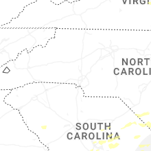
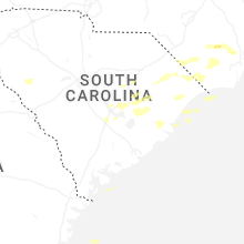
South Carolina
| Local Time | Report Details |
|---|---|
| 9:37 AM EDT | Edgefield county dispatch reports trees down on gilgal rd. time estimated from rada in edgefield county SC, 28.7 miles N of Augusta, GA |
| 10:38 AM EDT | Broadcast media relayed a picture of a tree down on the 900 block of tara trail causing minor damage to the property. time estimated by rada in lexington county SC, 61.7 miles NE of Augusta, GA |
| 11:06 AM EDT | Sc dot reports trees down on us 601 near the intersection with garners ferry rd. time estimated from rada in richland county SC, 64.4 miles NW of Charleston, SC |
| 11:20 AM EDT | Spotter reports a small tree down across sc 261 near dalzell... s in sumter county SC, 63.8 miles NNW of Charleston, SC |
| 12:07 PM EDT | Multiple trees reported down along highway 321 just outside of estill. time estimated from rada in hampton county SC, 49 miles N of Savannah, GA |
| 12:13 PM EDT | Quarter sized hail reported near Summerton, SC, 28 miles NNW of Charleston, SC, clarendon county em relayed a picture of approximately quarter sized hail in the wyboo neighborhood. time estimated by radar. |
| 12:13 PM EDT | Quarter sized hail reported near Olanta, SC, 52.1 miles N of Charleston, SC, hail estimated at nickel to quarter size briefly fell near this location. time estimated based on radar. |
| 12:16 PM EDT | Tree reported down in the 15000 block of sniders highway... likely due to thunderstorm outflow. time estimated from rada in colleton county SC, 55.7 miles WSW of Charleston, SC |
| 12:17 PM EDT | The sc dot webcam on i-95 near mile marker 93 shows trees down on the interstate blocking the road. time estimated from rada in orangeburg county SC, 32.1 miles WNW of Charleston, SC |
| 12:19 PM EDT | Tree reported down along charleston highway at shannon loop. time estimated from rada in dorchester county SC, 32.7 miles W of Charleston, SC |
| 12:22 PM EDT | Tree reported down in the 1700 block of highway 15. time estimated from rada in dorchester county SC, 30.7 miles W of Charleston, SC |
| 12:22 PM EDT | Powerlines reported down along garris ave at till lane. time estimated from rada in colleton county SC, 50.6 miles WSW of Charleston, SC |
| 12:25 PM EDT | Tree reported down onto a vehicle on highway 15n at duncan chapel road... no injuries. time estimated from rada in dorchester county SC, 29.9 miles WNW of Charleston, SC |
| 12:37 PM EDT | Tree reported down and blocking both lanes of state road at highway 311. time estimated from rada in berkeley county SC, 18.2 miles WNW of Charleston, SC |
| 12:45 PM EDT | Tree reported down on a powerline in the 100 block of pendarvis circle. time estimated from rada in dorchester county SC, 22.5 miles WSW of Charleston, SC |
| 12:45 PM EDT | Tree reported down in the 200 block of gruber street. time estimated from rada in colleton county SC, 41.9 miles WSW of Charleston, SC |
| 12:48 PM EDT | Tree reported down in the 8600 block of green pond highway... likely from thunderstorm outflow. time estimated from rada in colleton county SC, 46.4 miles SW of Charleston, SC |
| 12:51 PM EDT | Tree reported down along highway 17 near combahee road. time estimated from rada in colleton county SC, 50.2 miles NNE of Savannah, GA |
| 12:51 PM EDT | Trees reported down on powerlines along state road at sheep island road. time estimated from rada in berkeley county SC, 9.1 miles SW of Charleston, SC |
| 12:54 PM EDT | Powerlines reported down along ace basin parkway at ashepoo drive. time estimated from rada in colleton county SC, 44.7 miles SW of Charleston, SC |
| 12:54 PM EDT | Tree reported down on green pond hwy and clover hill rd. time estimated from radar. corrected for updated tim in colleton county SC, 46.8 miles SW of Charleston, SC |
| 12:55 PM EDT | Tree down in roadwa in williamsburg county SC, 41.8 miles NE of Charleston, SC |
| 1:00 PM EDT | Tree reported down on main street. time estimated from rada in berkeley county SC, 8.6 miles NNE of Charleston, SC |
| 1:00 PM EDT | Trees reported down on powerlines along gum ave. time estimated from rada in berkeley county SC, 7.3 miles SSE of Charleston, SC |
| 1:09 PM EDT | Trees reported down on power lines in the 100 block of w main street. time estiamted from rada in berkeley county SC, 0.5 miles WNW of Charleston, SC |
| 1:09 PM EDT | Tree reported down on trotters lane. time estimated from rada in berkeley county SC, 6.7 miles S of Charleston, SC |
| 1:12 PM EDT | Tree reported down on power line along the 1900 block of summers drive. time estimated from rada in dorchester county SC, 28 miles SW of Charleston, SC |
| 1:15 PM EDT | Tree down on road in lori in horry county SC, 72.9 miles NE of Charleston, SC |
| 1:15 PM EDT | Tree on down on road in lori in horry county SC, 72.9 miles NE of Charleston, SC |
| 1:20 PM EDT | Tree down blocking sc-19 near liner road in nichols. time estimated based on rada in horry county SC, 64.4 miles W of Wilmington, NC |
| 1:27 PM EDT | Tree reported down on bethera road near ackerman road. time estimated from rada in berkeley county SC, 11.9 miles E of Charleston, SC |
| 1:27 PM EDT | Powerlines reported down along hoover ave at berkeley street. time estimated from rada in berkeley county SC, 19.8 miles S of Charleston, SC |
| 1:29 PM EDT | Tree reported down along highway 17 near combahee road. time estimated from rada in colleton county SC, 50.2 miles NNE of Savannah, GA |
| 1:30 PM EDT | Tree down on cumbee r in georgetown county SC, 36.4 miles NE of Charleston, SC |
| 1:39 PM EDT | Tree down along highway 17 near steed creek. time estimated from rada in charleston county SC, 25.2 miles ESE of Charleston, SC |
| 1:42 PM EDT | Tree reported down along highway 17 at sam thompson drive. time estimated from rada in charleston county SC, 26.3 miles ESE of Charleston, SC |
| 1:50 PM EDT | Tree down on pennyroyal rd near mineral plac in georgetown county SC, 37.6 miles ENE of Charleston, SC |
| 1:50 PM EDT | Large branches down on power lines along paris lane in georgetown county SC, 35.9 miles ENE of Charleston, SC |
| 2:54 PM EDT | Tree reported down on green pond hwy and clover hill rd. time estimated from rada in colleton county SC, 46.8 miles SW of Charleston, SC |
Kansas
| Local Time | Report Details |
|---|---|
| 12:05 PM CDT | Quarter sized hail reported near Liberal, KS, 64.1 miles S of Garden City, KS, video via social media. |
| 2:56 PM CDT | Hen Egg sized hail reported near Bronson, KS, 26 miles ENE of Chanute, KS, report relayed via emergency management near bronson... kansas. |
| 3:10 PM CDT | Quarter sized hail reported near Fort Scott, KS, 39.5 miles ENE of Chanute, KS |
| 3:26 PM CDT | Hen Egg sized hail reported near Fort Scott, KS, 43.1 miles ENE of Chanute, KS, report relayed from em of 2 inch hail near fort scott... kansas. time estimated from radar. |
| 3:35 PM CDT | Fort scott awos measured a 60 mph wind gus in bourbon county KS, 38.2 miles ENE of Chanute, KS |
| 3:35 PM CDT | Quarter sized hail reported near Dodge City, KS, 46.4 miles ESE of Garden City, KS, report and photo of approximately quarter sized hail via social media. |
| 3:35 PM CDT | Quarter sized hail reported near Dodge City, KS, 49.3 miles ESE of Garden City, KS |
| 3:37 PM CDT | Quarter sized hail reported near Kanopolis, KS, 67.9 miles E of Hays, KS |
| 4:01 PM CDT | Three power poles down. time is radar estimate in sumner county KS, 44.2 miles S of Wichita, KS |
| 4:04 PM CDT | Trained spotter estimates at least 60 mp in sumner county KS, 44.7 miles SSW of Wichita, KS |
| 4:09 PM CDT | Quarter sized hail reported near Neodesha, KS, 26.1 miles SSW of Chanute, KS, marble to quarter sized hail reported by the independence daily reporter. |
| 4:11 PM CDT | Quarter sized hail reported near Caldwell, KS, 49.7 miles SSW of Wichita, KS, kake chaser reported lots of hail with mostly nickels but some quarter sized stones. |
| 4:11 PM CDT | Quarter sized hail reported near Girard, KS, 34.4 miles ESE of Chanute, KS, delayed report of quarter size hail north of girard. |
| 4:21 PM CDT | Quarter sized hail reported near Arma, KS, 42.8 miles ESE of Chanute, KS, report via social media of pea to quarter sized hail. time estimated via radar. |
| 5:12 PM CDT | Half Dollar sized hail reported near Columbus, KS, 46.3 miles SE of Chanute, KS, cocorahs report of half dollar sized hail 3.6 north of columbus... kansas. time estimated from radar. |
| 5:22 PM CDT | Quarter sized hail reported near Dexter, KS, 49.1 miles SE of Wichita, KS, nickel to up to quarter sized hail covering the ground. |
| 5:34 PM CDT | Amateur radio spotter just outside of galena... kansas reports high winds and 8 inch tree limbs down. time estimated from rada in cherokee county KS, 61 miles SE of Chanute, KS |
| 5:45 PM CDT | Pictures of large tree branches and a tree snapped off of bagdad road south of galen in cherokee county KS, 64.3 miles SE of Chanute, KS |
| 5:49 PM CDT | 50 to 60 mph winds were estimate in chautauqua county KS, 60.4 miles SE of Wichita, KS |
| 6:17 PM CDT | Half Dollar sized hail reported near Howard, KS, 48.5 miles WSW of Chanute, KS |
| 6:19 PM CDT | Golf Ball sized hail reported near Howard, KS, 46.7 miles WSW of Chanute, KS, relayed from a viewer. |
| 6:20 PM CDT | Quarter sized hail reported near Howard, KS, 46.7 miles WSW of Chanute, KS |
North Carolina
| Local Time | Report Details |
|---|---|
| 1:35 PM EDT | Tree down on strawberry blvd in columbus county NC, 50.4 miles W of Wilmington, NC |
| 1:35 PM EDT | Tree down along wright r in columbus county NC, 50.9 miles W of Wilmington, NC |
| 1:35 PM EDT | Tree down along midway drive... south of rough and ready roa in columbus county NC, 47.2 miles W of Wilmington, NC |
| 1:40 PM EDT | Tree down along mill pond r in columbus county NC, 43.4 miles W of Wilmington, NC |
| 1:43 PM EDT | Tree down along ramsey ford r in columbus county NC, 43.4 miles WSW of Wilmington, NC |
| 2:30 PM EDT | Tree down on 3rd and market in downtown wilmington in new hanover county NC, 0.4 miles NNW of Wilmington, NC |
| 2:45 PM EDT | Tree down on vehicle near white rd. and alamosa d in new hanover county NC, 6.8 miles ENE of Wilmington, NC |
| 3:07 PM EDT | Estimated 50 to 60 mph wind gusts along highway 24 near bogu in carteret county NC, 63.6 miles ENE of Wilmington, NC |
| 3:08 PM EDT | Farm cage destroyed. tree on 9 foot road. large branches down. report relayed via wct in carteret county NC, 71.3 miles ENE of Wilmington, NC |
| 3:11 PM EDT | Multiple trees down across the tow in carteret county NC, 60.3 miles ENE of Wilmington, NC |
| 3:13 PM EDT | Large top half of healthy tree blown down along nine mile road... near the intersection of gales creek road and nine mile. time estimated by rada in carteret county NC, 68.3 miles ENE of Wilmington, NC |
| 3:14 PM EDT | Flag pole snapped at the base. large tree branch on a home in the same locatio in carteret county NC, 72.7 miles ENE of Wilmington, NC |
| 3:14 PM EDT | Large branches down along roberts roa in carteret county NC, 70.5 miles ENE of Wilmington, NC |
| 3:18 PM EDT | Numerous trees reported down on the south side of haveloc in craven county NC, 73.6 miles NE of Wilmington, NC |
| 3:33 PM EDT | Power lines down across roadway along nc 101 near eastmans creek. tree also down in vicinity. report relayed via facebook... time estimated by rada in carteret county NC, 82.6 miles ENE of Wilmington, NC |
| 4:33 PM EDT | Peak wind gust of 51 knots measured at the ocracoke weatherflow statio in amz135 county NC, 111.4 miles S of Virginia Beach, VA |
| 4:33 PM EDT | Peak gust at the ocracoke weatherflow statio in hyde county NC, 113.5 miles S of Virginia Beach, VA |
| 5:05 PM EDT | Peak wind gust measured at the frisco woods weatherflow statio in dare county NC, 106.8 miles SSE of Virginia Beach, VA |
Oklahoma
| Local Time | Report Details |
|---|---|
| 2:14 PM CDT | Quarter sized hail reported near Tyrone, OK, 71.1 miles SSW of Garden City, KS, image sent to the em. |
| 2:58 PM CDT | Storm damage reported in grant county OK, 77.4 miles ENE of Woodward, OK |
| 3:57 PM CDT | Quarter sized hail reported near Balko, OK, 79.5 miles W of Woodward, OK |
| 4:09 PM CDT | Storm damage reported in kay county OK, 59.2 miles S of Wichita, KS |
| 5:20 PM CDT | Golf Ball sized hail reported near Cheyenne, OK, 67.9 miles SSW of Woodward, OK |
| 5:32 PM CDT | Quarter sized hail reported near Seiling, OK, 43.5 miles ESE of Woodward, OK |
| 5:35 PM CDT | Golf Ball sized hail reported near Longdale, OK, 48.4 miles ESE of Woodward, OK |
| 6:05 PM CDT | Tree down across road at 630 and e20 road... near alt us 69. time was estimated from rada in ottawa county OK, 61.8 miles SE of Chanute, KS |
| 6:10 PM CDT | Quarter sized hail reported near Canton, OK, 53.2 miles SE of Woodward, OK |
| 6:15 PM CDT | Awos station kclk clinto in custer county OK, 67.6 miles SSE of Woodward, OK |
| 6:20 PM CDT | Mesonet station wato watong in blaine county OK, 62.2 miles WNW of Oklahoma City, OK |
| 6:25 PM CDT | Mesonet station wato watong in blaine county OK, 62.2 miles WNW of Oklahoma City, OK |
| 7:15 PM CDT | Storm damage reported in mayes county OK, 39.6 miles ENE of Tulsa, OK |
| 7:15 PM CDT | Awos station kjwg watong in blaine county OK, 57.6 miles WNW of Oklahoma City, OK |
| 8:30 PM CDT | Trees and power lines down. radar estimated tim in carter county OK, 60 miles WSW of Atoka, OK |
| 8:30 PM CDT | Storm damage reported in carter county OK, 65.2 miles W of Atoka, OK |
| 8:37 PM CDT | Storm damage reported in cleveland county OK, 15.5 miles S of Oklahoma City, OK |
| 8:37 PM CDT | Near intersection of bridge rd and cemetery r in grady county OK, 20.6 miles SW of Oklahoma City, OK |
| 8:45 PM CDT | Power line down near 17th ave and earl st. radar estimated tim in johnston county OK, 45.1 miles WSW of Atoka, OK |
| 8:55 PM CDT | Roof damage to metal shop buildin in cleveland county OK, 23.9 miles SSE of Oklahoma City, OK |
| 9:45 PM CDT | Storm damage reported in atoka county OK, 9 miles SE of Atoka, OK |
| 9:50 PM CDT | Storm damage reported in atoka county OK, 9 miles SE of Atoka, OK |
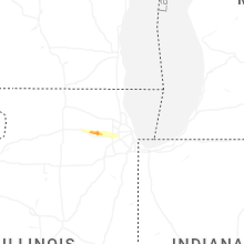
Illinois
| Local Time | Report Details |
|---|---|
| 2:15 PM CDT | Photo shared of 5 utility poles blown down near peace road and route 38. time estimate in de kalb county IL, 56.1 miles W of Chicago, IL |
| 2:15 PM CDT | Power poles downed onto webster road north of i-88 southeast of dekalb. time estimated from rada in de kalb county IL, 55.6 miles W of Chicago, IL |
| 2:43 PM CDT | Quarter sized hail reported near Elburn, IL, 42.7 miles W of Chicago, IL, multiple public reports of quarter size hail in elburn. time estimated from radar. |
| 2:45 PM CDT | Photos shared of trees and large tree limbs downed along main street west of bunker road. time estimated from rada in kane county IL, 41.3 miles W of Chicago, IL |
| 2:45 PM CDT | Golf Ball sized hail reported near Elburn, IL, 42.2 miles W of Chicago, IL, hail ranged from quarter to golf ball size on the southwest side of geneva. |
| 2:54 PM CDT | Ping Pong Ball sized hail reported near Geneva, IL, 38.6 miles W of Chicago, IL, photo shared of a hailstone just under 1.5 inches in diameter. |
| 2:54 PM CDT | Hen Egg sized hail reported near Batavia, IL, 37.1 miles W of Chicago, IL, 2 inch diameter hail reported near fabyan parkway and branson drive in batavia. |
| 2:56 PM CDT | Golf Ball sized hail reported near Batavia, IL, 38.1 miles W of Chicago, IL, golf ball size hail reported at main street and nelson lake road in batavia. |
| 2:56 PM CDT | Hen Egg sized hail reported near Batavia, IL, 35.6 miles W of Chicago, IL, trained spotter shared photos of multiple elongated hailstones measuring greater than 2 inches in diameter in batavia. |
| 2:56 PM CDT | Quarter sized hail reported near Batavia, IL, 35.5 miles W of Chicago, IL, mping report. |
| 2:56 PM CDT | Quarter sized hail reported near Batavia, IL, 36.6 miles W of Chicago, IL, quarter size hail reported at randall road and main street in batavia. |
| 2:56 PM CDT | Tennis Ball sized hail reported near Batavia, IL, 36.5 miles W of Chicago, IL, mping report. |
| 2:57 PM CDT | Tennis Ball sized hail reported near Batavia, IL, 35 miles W of Chicago, IL, meteorology professor reported hail up to 2.5 inches in diameter in batavia. average hailstone diameter was approximately 2 inches. |
| 2:57 PM CDT | Hen Egg sized hail reported near Batavia, IL, 36.6 miles W of Chicago, IL, mping report. |
| 2:57 PM CDT | Tennis Ball sized hail reported near Batavia, IL, 35.6 miles W of Chicago, IL, photo shared on social media of approximately 2 to 2.5 inch diameter hail in batavia. a video shared under the same post showed wind-driven hail destroying a window scr |
| 2:57 PM CDT | Quarter sized hail reported near Batavia, IL, 35 miles W of Chicago, IL, quarter size hail reported at first street and lincoln street in batavia. |
| 2:58 PM CDT | Golf Ball sized hail reported near Batavia, IL, 35 miles W of Chicago, IL, coop observer in batavia reported wind-driven hail with the largest hailstones approximately golf ball sized. |
| 2:58 PM CDT | Coop observer estimated 70 mph wind gusts in batavia. large tree branches were downe in kane county IL, 35 miles W of Chicago, IL |
| 2:58 PM CDT | Hen Egg sized hail reported near Batavia, IL, 36.1 miles W of Chicago, IL, photo shared on social media showing hailstones roughly twice the size of a quarter along main street east of randall road in batavia. |
| 2:58 PM CDT | Large tree snapped at harrison street and carlisle road in batavi in kane county IL, 35.6 miles W of Chicago, IL |
| 3:23 PM CDT | Large tree branches downed at multiple residences near lacey road and ogden avenue in downers grov in dupage county IL, 21.1 miles WSW of Chicago, IL |
| 4:03 PM CDT | A large tree was damage in sangamon county IL, 58.8 miles S of Peoria, IL |
| 12:07 AM CDT | Trees down... powerlines down... box trailer flipped along highway 14 in jackson county IL, 33.8 miles NNE of Cape Girardeau, MO |
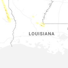
Louisiana
| Local Time | Report Details |
|---|---|
| 3:15 PM CDT | Sheriffs office reported trees down om carver roa in west feliciana county LA, 58.7 miles NE of Lafayette, LA |
| 4:47 PM CDT | Quarter sized hail reported near Lettsworth, LA, 49.7 miles NNE of Lafayette, LA, public reported quarter sized hail. |
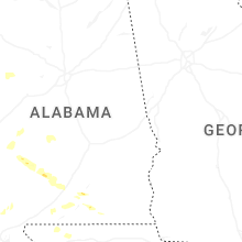
Alabama
| Local Time | Report Details |
|---|---|
| 3:15 PM CDT | Quarter sized hail reported near Opp, AL, 61.7 miles N of Miramar Beach, FL, public report of quarter size hail. |
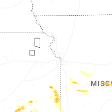
Missouri
| Local Time | Report Details |
|---|---|
| 3:25 PM CDT | Quarter sized hail reported near Butler, MO, 57.3 miles SSE of Kansas City, MO, social media picture east of ballard. |
| 3:29 PM CDT | Golf Ball sized hail reported near Montrose, MO, 60.9 miles SSE of Kansas City, MO, emergency manager relayed pictures of large hail nw of montrose. time estimated from radar. |
| 3:32 PM CDT | Half Dollar sized hail reported near Montrose, MO, 63.8 miles SSE of Kansas City, MO, emergency manager relayed photo of quarter to half dollar sized hail in the unincorporated town of germantown. |
| 3:44 PM CDT | Hen Egg sized hail reported near Clinton, MO, 66.6 miles SE of Kansas City, MO, emergency manager relayed photo of measured hail between 2 and 2.5 inches. |
| 5:38 PM CDT | Report via social media of a tree down over the road. time estimated via rada in jasper county MO, 64.3 miles SE of Chanute, KS |
| 5:56 PM CDT | Quarter sized hail reported near Rich Hill, MO, 67.6 miles S of Kansas City, MO, emergency manager relayed report of quarter hail just north of rich hill along i49. |
| 7:15 PM CDT | Half Dollar sized hail reported near Osceola, MO, 62.2 miles NNW of Springfield, MO, picture of hail just larger than quarter size in osceola. |
| 7:32 PM CDT | Quarter sized hail reported near Steelville, MO, 25.1 miles NNE of Salem, MO |
| 8:02 PM CDT | Quarter sized hail reported near Salem, MO, 3.6 miles NNE of Salem, MO, report from mping - quarter 1.00 in. |
| 8:06 PM CDT | Quarter sized hail reported near Eldon, MO, 47.9 miles SSW of Columbia, MO, hail reported to cover the ground. |
| 8:09 PM CDT | Golf Ball sized hail reported near Eldon, MO, 48.2 miles SSW of Columbia, MO, photo from social media of several stones between half dollar and golf ball size hail. large volume of hail reported within the storm... with missouri state highway pat |
| 12:50 AM CDT | Poplar bluff aso in butler county MO, 56.4 miles SW of Cape Girardeau, MO |
Wisconsin
| Local Time | Report Details |
|---|---|
| 5:14 PM CDT | Quarter sized hail reported near Shawano, WI, 34.5 miles WNW of Green Bay, WI, report from mping: quarter (1.00 in.). |
| 5:17 PM CDT | Quarter sized hail reported near Shawano, WI, 33.6 miles NW of Green Bay, WI, facebook post with pictures of nickel to quarter size hail. |
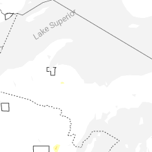
Michigan
| Local Time | Report Details |
|---|---|
| 7:03 PM EDT | Quarter sized hail reported near Champion, MI, 26.2 miles W of Marquette, MI, time estimated from radar. |
New Mexico
| Local Time | Report Details |
|---|---|
| 5:23 PM MDT | Quarter sized hail reported near Gladstone, NM, 83.3 miles N of Tucumcari, NM, trained spotter reports quarter size hail in his ranch near gladstone. |
| 6:27 PM MDT | Awos station kcvs cannon air force bas in curry county NM, 60.3 miles SSE of Tucumcari, NM |
Indiana
| Local Time | Report Details |
|---|---|
| 8:05 PM EDT | Large treen downe in elkhart county IN, 56.9 miles NW of Fort Wayne, IN |
| 8:05 PM EDT | Corrects previous tstm wnd dmg report from 1 se dunlap. part of shed roof blown of in elkhart county IN, 55.2 miles NW of Fort Wayne, IN |
| 8:10 PM EDT | 8-10 inch diameter limbs broke in elkhart county IN, 53.9 miles NW of Fort Wayne, IN |
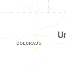
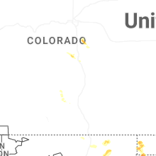
Colorado
| Local Time | Report Details |
|---|---|
| 6:08 PM MDT | Quarter sized hail reported near Elbert, CO, 41 miles SSE of Denver, CO |
Connect with Interactive Hail Maps