

Hail Map for Saturday, July 23, 2016

Number of Impacted Households on 7/23/2016
0
Impacted by 1" or Larger Hail
0
Impacted by 1.75" or Larger Hail
0
Impacted by 2.5" or Larger Hail
Square Miles of Populated Area Impacted on 7/23/2016
0
Impacted by 1" or Larger Hail
0
Impacted by 1.75" or Larger Hail
0
Impacted by 2.5" or Larger Hail


Cities Most Affected by Hail Storms of 7/23/2016
| Hail Size | Demographics of Zip Codes Affected | ||||||
|---|---|---|---|---|---|---|---|
| City | Count | Average | Largest | Pop Density | House Value | Income | Age |
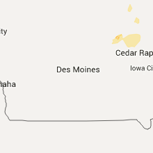
| Atwater, MN | 1 | 2.00 | 2.00 | 17 | $79k | $42.1k | 44.7 |
Hail and Wind Damage Spotted on 7/23/2016
Filter by Report Type:Hail ReportsWind Reports
States Impacted
South Dakota, North Dakota, Minnesota, Wisconsin, Vermont, New York, Maine, New Hampshire, Pennsylvania, Iowa, Delaware, New Jersey, North Carolina, Massachusetts, Maryland, Arkansas, Illinois, Texas, Tennessee, Colorado, Rhode Island, FloridaSouth Dakota
| Local Time | Report Details |
|---|---|
| 6:00 AM MDT | Storm damage reported in dewey county SD, 44.4 miles N of Pierre, SD |
North Dakota
| Local Time | Report Details |
|---|---|
| 9:12 AM CDT | Quarter sized hail reported near Driscoll, ND, 38.9 miles E of Bismarck, ND |
Minnesota
| Local Time | Report Details |
|---|---|
| 9:32 AM CDT | Large tree branch down blocking traffic in dodge county MN, 54.3 miles NNE of Mason City, IA |
| 10:20 AM CDT | Large tree down. in dakota county MN, 18.6 miles S of Minneapolis, MN |
| 10:40 AM CDT | Power lines dow in goodhue county MN, 42.8 miles SE of Minneapolis, MN |
| 10:40 AM CDT | Multiple trees down in goodhue county MN, 55.9 miles SSE of Minneapolis, MN |
| 10:41 AM CDT | A few trees dow in dakota county MN, 24.5 miles S of Minneapolis, MN |
| 10:50 AM CDT | Large branch snapped off. social media imag in dakota county MN, 21.7 miles S of Minneapolis, MN |
| 11:11 AM CDT | Multiple trees dow in washington county MN, 19.8 miles ESE of Minneapolis, MN |
| 1:25 PM CDT | Hen Egg sized hail reported near Atwater, MN, 49.6 miles E of Montevideo, MN, hail diameter 2.25 inches. mostly one inch hail... lasted approximately 5 minutes. vehicles... house siding damaged. also measured 3 inches of rain in 1.5 hours. |
| 2:05 PM CDT | A few 3 inch diameter tree branches dow in mcleod county MN, 53.4 miles W of Minneapolis, MN |
Wisconsin
| Local Time | Report Details |
|---|---|
| 11:00 AM CDT | Multiple trees dow in pierce county WI, 41.9 miles ESE of Minneapolis, MN |
| 11:08 AM CDT | Multiple trees down... in pierce county WI, 30.2 miles ESE of Minneapolis, MN |
| 1:52 PM CDT | Tree damage in mount horeb area per dispatch. time estimated from rada in dane county WI, 17.9 miles WSW of Madison, WI |
| 2:25 PM CDT | Quarter sized hail reported near Clinton, WI, 44.1 miles SE of Madison, WI, . |
| 2:45 PM CDT | Tree branches down in pardeevill in columbia county WI, 31.9 miles N of Madison, WI |
Vermont
| Local Time | Report Details |
|---|---|
| 2:45 PM EDT | Trees down in grand isle county VT, 17.3 miles NNW of Burlington, VT |
| 3:24 PM EDT | Trees down...rt 2a blocke in chittenden county VT, 4.6 miles NE of Burlington, VT |
| 3:25 PM EDT | Trees down...power lines down on dorset stree in chittenden county VT, 2.2 miles E of Burlington, VT |
| 3:35 PM EDT | Trees down in chittenden county VT, 5.2 miles E of Burlington, VT |
| 3:36 PM EDT | Power lines down on road in chittenden county VT, 11.9 miles ESE of Burlington, VT |
| 3:40 PM EDT | A few trees down in chittenden county VT, 6.7 miles S of Burlington, VT |
| 3:47 PM EDT | Trees down...power lines down in chittenden county VT, 11.6 miles S of Burlington, VT |
| 4:00 PM EDT | Trees down on powerlines in washington county VT, 26.1 miles SE of Burlington, VT |
| 4:00 PM EDT | Numerous trees down in addison county VT, 31.6 miles S of Burlington, VT |
| 4:02 PM EDT | Tree down in addison county VT, 16.3 miles SSE of Burlington, VT |
| 4:12 PM EDT | Shingles blown off roof...power is ou in addison county VT, 27.4 miles SSE of Burlington, VT |
| 4:18 PM EDT | Trees down on main road in rutland county VT, 47.1 miles S of Burlington, VT |
| 4:19 PM EDT | Trees down on route 12 near wrightsville dam in washington county VT, 33.4 miles ESE of Burlington, VT |
| 4:20 PM EDT | Reports of numerous trees downed or snapped along interstate 89 bewteen mile markers 50 in barre to mile marker 25 near bethel in orange county VT, 42.8 miles SE of Burlington, VT |
| 4:27 PM EDT | Reports of numerous trees downed or snapped along interstate 89 bewteen mile markers 50 in barre to mile marker 25 near bethel in orange county VT, 42.8 miles SE of Burlington, VT |
| 4:27 PM EDT | Trees down on route 30 in rutland county VT, 52.9 miles S of Burlington, VT |
| 4:30 PM EDT | *** 1 fatal *** trees down in rutland county VT, 55 miles S of Burlington, VT |
| 4:40 PM EDT | Trees down...power lines down in orange county VT, 43.5 miles SE of Burlington, VT |
| 4:52 PM EDT | Trees down on cricket hill road in rutland county VT, 55.6 miles SSE of Burlington, VT |
| 4:55 PM EDT | Trees down in orange county VT, 65.4 miles SE of Burlington, VT |
| 5:00 PM EDT | Trees down on post road in rutland county VT, 59.1 miles SSE of Burlington, VT |
| 5:20 PM EDT | Trees down in windsor county VT, 56 miles SE of Burlington, VT |
| 5:20 PM EDT | Trees down on i-89 at mile marker 15.8 southboun in windsor county VT, 58.9 miles SE of Burlington, VT |
| 5:27 PM EDT | Few trees down in windsor county VT, 81 miles ENE of Schenectady, NY |
| 5:35 PM EDT | Trees down throughout down in windsor county VT, 75.1 miles ENE of Schenectady, NY |
| 6:15 PM EDT | Trees down. time estimated by rada in bennington county VT, 39.8 miles ENE of Schenectady, NY |
New York
| Local Time | Report Details |
|---|---|
| 3:05 PM EDT | Trees down in clinton county NY, 38.3 miles WNW of Burlington, VT |
| 3:07 PM EDT | Quarter sized hail reported near Lyon Mountain, NY, 38.3 miles WNW of Burlington, VT |
| 3:24 PM EDT | Trees down in clinton county NY, 17.2 miles WNW of Burlington, VT |
| 3:24 PM EDT | Trees down in clinton county NY, 41.7 miles WNW of Burlington, VT |
| 3:25 PM EDT | Trees down on course and dime sized hail in franklin county NY, 47.5 miles E of Ogdensburg, NY |
| 3:40 PM EDT | Trees down in clinton county NY, 17.2 miles WNW of Burlington, VT |
| 4:00 PM EDT | Power outages in jay township. numerous trees on lines across essex county in essex county NY, 23.2 miles WSW of Burlington, VT |
| 4:12 PM EDT | *** 1 inj *** trees on residence resulting in an injury in saratoga county NY, 34.1 miles N of Schenectady, NY |
| 4:15 PM EDT | Quarter sized hail reported near Argyle, NY, 43.1 miles NE of Schenectady, NY, spotter report |
| 4:30 PM EDT | Multiple trees and wires down on residenc in fulton county NY, 35.5 miles NW of Schenectady, NY |
| 6:45 PM EDT | Many trees down with power outages in rom in oneida county NY, 35.5 miles ENE of Syracuse, NY |
| 6:55 PM EDT | Eureka road closed in westmoreland due to fallen trees. many trees down from westmoreland to clinton with power outage in oneida county NY, 37.1 miles E of Syracuse, NY |
| 7:00 PM EDT | Trees down with power outages around clark mill in oneida county NY, 38.9 miles E of Syracuse, NY |
| 7:00 PM EDT | A tree down in road at krumkill rd and salem ct in albany county NY, 11.1 miles SSE of Schenectady, NY |
| 7:10 PM EDT | Quarter sized hail reported near Clinton, NY, 38.9 miles E of Syracuse, NY |
Maine
| Local Time | Report Details |
|---|---|
| 3:25 PM EDT | Trees and wires down in cumberland county ME, 27.6 miles NNW of Portland, ME |
| 3:35 PM EDT | Trees and power lines down. power outage in oxford county ME, 34.6 miles NW of Portland, ME |
| 4:05 PM EDT | Quarter sized hail reported near Durham, ME, 22.5 miles NNE of Portland, ME |
| 4:10 PM EDT | Large branches on wire in cumberland county ME, 15.9 miles NNE of Portland, ME |
| 4:15 PM EDT | Power lines down on meridian in cumberland county ME, 0.2 miles WNW of Portland, ME |
| 4:20 PM EDT | Trees and power lines down on brook street. tree on buildin in cumberland county ME, 3.3 miles E of Portland, ME |
| 4:25 PM EDT | Trees and power lines down in cumberland county ME, 16.9 miles NE of Portland, ME |
New Hampshire
| Local Time | Report Details |
|---|---|
| 4:10 PM EDT | Large branches down in carroll county NH, 53.4 miles WNW of Portland, ME |
| 5:15 PM EDT | Trees and wires down on beauty hill road in belknap county NH, 56.7 miles WSW of Portland, ME |
| 5:15 PM EDT | Dozens of trees dow in carroll county NH, 52.1 miles WNW of Portland, ME |
| 5:15 PM EDT | Trees dow in grafton county NH, 72.5 miles W of Portland, ME |
| 5:17 PM EDT | Trees and wires down on texas hill roa in grafton county NH, 72.1 miles W of Portland, ME |
| 5:24 PM EDT | Trees down west shore r in grafton county NH, 76.9 miles W of Portland, ME |
| 5:25 PM EDT | Wires down on porter roa in sullivan county NH, 91.3 miles ENE of Schenectady, NY |
| 5:29 PM EDT | Numerous trees dow in carroll county NH, 52.1 miles WNW of Portland, ME |
| 5:30 PM EDT | Wires down at the intersection of plains road and currier roa in merrimack county NH, 79.9 miles W of Portland, ME |
| 5:30 PM EDT | Wires down on brookdale roa in grafton county NH, 74.4 miles W of Portland, ME |
| 5:35 PM EDT | Wires down on hill roa in merrimack county NH, 71.9 miles W of Portland, ME |
| 5:40 PM EDT | Tree down on house on russell roa in merrimack county NH, 71.6 miles WSW of Portland, ME |
| 5:40 PM EDT | Tress down on houses and wires. multiple roads closed. route 132 and 127 close in belknap county NH, 67.4 miles W of Portland, ME |
| 5:40 PM EDT | Tress down on houses and wires. multiple roads closed. route 132 and 127 close in belknap county NH, 67.4 miles W of Portland, ME |
| 5:45 PM EDT | Wires dow in belknap county NH, 66.8 miles W of Portland, ME |
| 5:45 PM EDT | Trees on wires and pea sized hail in belknap county NH, 62 miles W of Portland, ME |
| 5:50 PM EDT | Tree on a house at the intersection of pleasant and high street in merrimack county NH, 70 miles WSW of Portland, ME |
| 5:50 PM EDT | Trees and wires down in merrimack county NH, 85.3 miles WSW of Portland, ME |
| 6:00 PM EDT | Trees and wires down in strafford county NH, 44.9 miles WSW of Portland, ME |
| 6:10 PM EDT | Trees and wires down in rockingham county NH, 59.9 miles SW of Portland, ME |
| 6:15 PM EDT | Trees and power lines down at nh-136 e and ferson roa in hillsborough county NH, 83 miles NNW of Providence, RI |
| 6:15 PM EDT | Nh-136 e at scobie road...trees and power lines dow in hillsborough county NH, 81.1 miles N of Providence, RI |
| 6:35 PM EDT | Tree fell on a house on greenwood roa in hillsborough county NH, 72.3 miles N of Providence, RI |
| 6:35 PM EDT | Multiple trees and power lines dow in hillsborough county NH, 70.6 miles N of Providence, RI |
| 6:35 PM EDT | Trees and wires dow in hillsborough county NH, 72.4 miles N of Providence, RI |
| 6:48 PM EDT | Trees down in hillsborough county NH, 64 miles N of Providence, RI |
| 6:50 PM EDT | Trees and wires down in hillsborough county NH, 63.8 miles NNW of Providence, RI |
| 6:55 PM EDT | Quarter sized hail reported near Seabrook, NH, 61.4 miles SSW of Portland, ME |
Pennsylvania
| Local Time | Report Details |
|---|---|
| 4:20 PM EDT | Roof blown off trailer in rapho townshi in lancaster county PA, 54.7 miles N of Baltimore, MD |
| 4:23 PM EDT | Quarter sized hail reported near Lancaster, PA, 54.3 miles NNE of Baltimore, MD, nickel to quarter size hail in lancaster. |
| 4:30 PM EDT | Large tree limbs down. time estimated from rada in chester county PA, 55.4 miles NE of Baltimore, MD |
| 4:35 PM EDT | Multiple trees down in manor townshi in lancaster county PA, 51.2 miles NNE of Baltimore, MD |
| 4:36 PM EDT | Multiple trees down on st. rt. 837 between elrama and new eagle in washington county PA, 15.9 miles S of Pittsburgh, PA |
| 4:42 PM EDT | Trees and wires down on school lane and berkeley road. damage to a roo in montgomery county PA, 82.9 miles WSW of Brooklyn, NY |
| 5:00 PM EDT | Trees and power poles down in sadsbury township... and the borough of christian in lancaster county PA, 55.9 miles NE of Baltimore, MD |
| 5:07 PM EDT | Utility pole and wires down... trees dow in chester county PA, 56.5 miles NE of Baltimore, MD |
| 5:07 PM EDT | Tree fell into septa train wires. two people rescued from trai in chester county PA, 66.3 miles NE of Baltimore, MD |
| 5:15 PM EDT | Quarter sized hail reported near Airville, PA, 38.7 miles NNE of Baltimore, MD, quarter size hail in airville. |
| 5:35 PM EDT | Multiple trees down in manor townshi in lancaster county PA, 51.2 miles NNE of Baltimore, MD |
| 5:57 PM EDT | 12 trees down across morey road in washington county PA, 30.3 miles S of Pittsburgh, PA |
| 6:00 PM EDT | Trees and power poles down in sadsbury township... and the borough of christian in lancaster county PA, 55.9 miles NE of Baltimore, MD |
Iowa
| Local Time | Report Details |
|---|---|
| 3:30 PM CDT | Very heavy rain and winds to 65 mp in buchanan county IA, 36.2 miles NNW of Cedar Rapids, IA |
| 3:35 PM CDT | Wind estimated 60 to 65 mph in buchanan county IA, 37.1 miles NNW of Cedar Rapids, IA |
| 3:35 PM CDT | Wind estimated 60 to 65 mph in buchanan county IA, 37.1 miles NNW of Cedar Rapids, IA |
| 3:49 PM CDT | Wind estimated 70 to 80 mph downed trees at campground in buchanan county IA, 44.7 miles NNW of Cedar Rapids, IA |
| 3:49 PM CDT | Wind estimated 70 to 80 mph downed trees at campground in buchanan county IA, 44.7 miles NNW of Cedar Rapids, IA |
| 4:03 PM CDT | Numerous branches and tree limbs down across tow in buchanan county IA, 35.7 miles NNW of Cedar Rapids, IA |
| 4:10 PM CDT | 2 estimated 8 inch diamater trees down. report via twitter. time estimated by rada in delaware county IA, 37.1 miles NNE of Cedar Rapids, IA |
| 4:21 PM CDT | 3 limbs approximately 6 to 12 inches in diameter were dow in delaware county IA, 35.9 miles NNE of Cedar Rapids, IA |
| 4:25 PM CDT | Several large trees and branches down. via facebook. report was delayed and time estimated using rada in delaware county IA, 33.2 miles NE of Cedar Rapids, IA |
| 5:30 PM CDT | Partial trees down - time estimated in jones county IA, 35.2 miles E of Cedar Rapids, IA |
Delaware
| Local Time | Report Details |
|---|---|
| 5:15 PM EDT | Trees and wires down on centerville road in new castle county DE, 65.2 miles ENE of Baltimore, MD |
| 6:11 PM EDT | Trees and wires down on bunker hill roa in new castle county DE, 49.4 miles ENE of Baltimore, MD |
New Jersey
| Local Time | Report Details |
|---|---|
| 5:29 PM EDT | Quarter sized hail reported near Audubon, NJ, 79.5 miles SW of Brooklyn, NY |
| 5:30 PM EDT | Quarter sized hail reported near Collingswood, NJ, 77.8 miles SW of Brooklyn, NY, quarter size hail. time estimated from radar. |
| 5:30 PM EDT | Several trees down in the glendora and runnemede areas. time estimated from rada in camden county NJ, 81.9 miles SW of Brooklyn, NY |
| 5:30 PM EDT | A large tree completely toppled over onto two cars on the 400 block of lincoln avenue. a woman was trapped in one of the cars and had to be rescued. time estimated from in camden county NJ, 79.8 miles SW of Brooklyn, NY |
| 5:33 PM EDT | Trees down on cars at intersection of barr drive and clements drive in camden county NJ, 79.7 miles SW of Brooklyn, NY |
| 5:33 PM EDT | Quarter sized hail reported near Haddonfield, NJ, 77.9 miles SW of Brooklyn, NY |
| 5:35 PM EDT | Power pole snapped in hal in camden county NJ, 79 miles SW of Brooklyn, NY |
| 5:35 PM EDT | Large tree limbs down on burbank drive. time estimated from rada in camden county NJ, 79.6 miles SW of Brooklyn, NY |
| 5:37 PM EDT | Downed wires on burnt mill roa in camden county NJ, 77.5 miles SW of Brooklyn, NY |
| 7:10 PM EDT | Trees and power lines down. power outages. time estimated from rada in cumberland county NJ, 68.7 miles N of Ocean City, MD |
North Carolina
| Local Time | Report Details |
|---|---|
| 5:40 PM EDT | One tree down near the intersection of odell school road and shiloh church roa in cabarrus county NC, 17.8 miles NNE of Charlotte, NC |
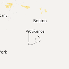
Massachusetts
| Local Time | Report Details |
|---|---|
| 5:52 PM EDT | Wires down on irving street. tree down on house on sheffield road. large tree branch down on madison avenue and cambridge street. tree down on main street by the rec de in middlesex county MA, 45.3 miles NNE of Providence, RI |
| 6:00 PM EDT | Wires down on hanover street. trees and wires down in several location in middlesex county MA, 45.6 miles NNE of Providence, RI |
| 6:00 PM EDT | Large tree limb dow in middlesex county MA, 44 miles NNE of Providence, RI |
| 6:00 PM EDT | Large limbs down on whitman...lionel...and middle streets. tree and wires down on lionel and middle street in middlesex county MA, 46.8 miles NNE of Providence, RI |
| 6:00 PM EDT | Several branches and trees down at the corner of washington and arnol in middlesex county MA, 43.1 miles NNE of Providence, RI |
| 6:00 PM EDT | Large tree down on bacon stree in middlesex county MA, 45.3 miles NNE of Providence, RI |
| 6:01 PM EDT | Tree branch dow in middlesex county MA, 43.1 miles NNE of Providence, RI |
| 6:05 PM EDT | Tree down on avon stree in middlesex county MA, 44.5 miles NNE of Providence, RI |
| 6:10 PM EDT | Tent blown over on revere beach. tree and power lines down on endicott avenue and on caruso street. wires down on vinyl stree in suffolk county MA, 46.5 miles NNE of Providence, RI |
| 6:50 PM EDT | Tree down and transformer blew on liberty stree in essex county MA, 68 miles NNE of Providence, RI |
| 6:50 PM EDT | Tree down in the right lane of 213 westboun in essex county MA, 63 miles N of Providence, RI |
| 6:52 PM EDT | Numerous trees down throughout town...including a tree down onto a car. wires down on steven street and fairmont street. large tree down on wires on greendale avenue. w in middlesex county MA, 56.5 miles N of Providence, RI |
| 6:54 PM EDT | Two large trees dow in middlesex county MA, 52.2 miles N of Providence, RI |
| 6:54 PM EDT | Several trees and wires down on main street and mechanic stree in essex county MA, 70.2 miles SSW of Portland, ME |
| 6:55 PM EDT | Power lines down on cold spring at granitevill in middlesex county MA, 50.9 miles NNW of Providence, RI |
| 6:56 PM EDT | Trees were downed on dock lane...true road...and cushing roa in essex county MA, 64.4 miles SSW of Portland, ME |
| 6:59 PM EDT | Tree down on river street. large branch down on wires on concord stree in middlesex county MA, 50.6 miles N of Providence, RI |
| 7:00 PM EDT | Power lines and a tree down on jonathan lan in middlesex county MA, 53.6 miles N of Providence, RI |
| 7:00 PM EDT | Power lines and a tree down on jonathan lan in middlesex county MA, 53.6 miles N of Providence, RI |
| 7:00 PM EDT | Tree down on north stree in middlesex county MA, 54.4 miles NNE of Providence, RI |
| 7:02 PM EDT | Trees down on ipswich road...barehill road...whitney road. motorcyclist down on downed wires on georgetown road near hillside roa in essex county MA, 62.3 miles NNE of Providence, RI |
| 7:03 PM EDT | Trees and wires down in various locations throughout tow in worcester county MA, 45.2 miles NNW of Providence, RI |
| 7:05 PM EDT | Tree down blocking high stree in worcester county MA, 56.9 miles NNW of Providence, RI |
| 7:06 PM EDT | Multiple trees and wires down in west peabody... including on lowell street... newbridge road... and pocahontas driv in essex county MA, 53.8 miles NNE of Providence, RI |
| 7:07 PM EDT | Tree down on route 78. tree and wires down on east road. tree down on east river stree in franklin county MA, 69.8 miles NW of Providence, RI |
| 7:08 PM EDT | Wires down and a tree uproote in worcester county MA, 51.4 miles NNW of Providence, RI |
| 7:09 PM EDT | Big tree dow in middlesex county MA, 61.4 miles NNW of Providence, RI |
| 7:09 PM EDT | Large branch down on concord stree in middlesex county MA, 50.6 miles N of Providence, RI |
| 7:11 PM EDT | Trees and power lines down on lowell roa in middlesex county MA, 54.9 miles N of Providence, RI |
| 7:12 PM EDT | Tree down onto the colonial inn. tree down across shagbark road...everett street...and main stree in middlesex county MA, 43.3 miles N of Providence, RI |
| 7:15 PM EDT | Large tree and power lines down in wychwood height in middlesex county MA, 49.5 miles N of Providence, RI |
| 7:15 PM EDT | Tree down on a car on fowler avenu in suffolk county MA, 46.5 miles NNE of Providence, RI |
| 7:15 PM EDT | Multiple small boats in distress on the merrimack rive in essex county MA, 64.4 miles SSW of Portland, ME |
| 7:23 PM EDT | *** 1 inj *** awning fell onto a pedestrian at the lenox hotel on exeter street. person was injure in suffolk county MA, 38.5 miles NNE of Providence, RI |
| 7:25 PM EDT | Tree down on car on westford road. tree down on wires on old stow road. wires downed on lindsay pond roa in middlesex county MA, 43.3 miles N of Providence, RI |
| 7:27 PM EDT | Numerous trees and wires down...including valley road and route 9 in essex county MA, 60.9 miles NNE of Providence, RI |
| 7:30 PM EDT | Multiple trees and wires down...including on barstool street. a tree was downed onto a car on forrester and washington streets. tree down on houston road. portion of a in suffolk county MA, 38.5 miles NNE of Providence, RI |
| 7:30 PM EDT | Tree down on boylston stree in suffolk county MA, 36.1 miles NNE of Providence, RI |
| 7:30 PM EDT | Tree down blocking willow stree in worcester county MA, 51.4 miles NNW of Providence, RI |
| 7:30 PM EDT | Large branch down on meadow roa in worcester county MA, 35.7 miles NNW of Providence, RI |
| 7:31 PM EDT | Power lines down on burncoat stree in worcester county MA, 37 miles NNW of Providence, RI |
| 7:31 PM EDT | Tree dow in worcester county MA, 35.7 miles NNW of Providence, RI |
| 7:32 PM EDT | Tree down on willow stree in worcester county MA, 51.4 miles NNW of Providence, RI |
| 7:32 PM EDT | Large branch dow in middlesex county MA, 51.8 miles NNE of Providence, RI |
| 7:35 PM EDT | Large limb down on power lines on hancock stree in middlesex county MA, 44.2 miles NNE of Providence, RI |
| 7:35 PM EDT | Branch down on a garage on charles stree in middlesex county MA, 40.1 miles NNE of Providence, RI |
| 7:44 PM EDT | Multiple trees...limbs...and wires down in multiple location in essex county MA, 50.3 miles NNE of Providence, RI |
| 7:44 PM EDT | Tree down on wires on massachusetts avenue near harvard law schoo in middlesex county MA, 41.2 miles NNE of Providence, RI |
| 8:21 PM EDT | Tree down on wires on westerly roa in plymouth county MA, 38.9 miles ENE of Providence, RI |
| 8:35 PM EDT | Tree down on car on coolidge stree in bristol county MA, 27.6 miles SE of Providence, RI |
| 8:35 PM EDT | Large branch on car on howart at conduit street. tree down in the buttonwood park area. tree down on union and 6th street. tree down on aquidneck at brock avenue. tree in bristol county MA, 26.9 miles ESE of Providence, RI |
Maryland
| Local Time | Report Details |
|---|---|
| 5:55 PM EDT | Several trees snapped in half. shingles off of some roofs. time estimated from rada in cecil county MD, 47.3 miles ENE of Baltimore, MD |
| 5:58 PM EDT | Storm damage reported in cecil county MD, 45.9 miles ENE of Baltimore, MD |
| 6:03 PM EDT | Trees down. time estimated from rada in cecil county MD, 46.1 miles ENE of Baltimore, MD |
| 6:15 PM EDT | Trees down near rt 136 between telegraph and onion rd in harford county MD, 29.2 miles NNE of Baltimore, MD |
| 6:25 PM EDT | Trees down near intersection of st ann dr and md-543 in harford county MD, 27.8 miles NNE of Baltimore, MD |
| 6:35 PM EDT | Trees down along n tollgate rd near ma and pa hertiage trail in harford county MD, 20.9 miles NE of Baltimore, MD |
| 6:54 PM EDT | Trees down near 1205 grafton shop rd in harford county MD, 20.8 miles NE of Baltimore, MD |
| 6:58 PM EDT | Trees down at red pump rd and ennis way in harford county MD, 21.1 miles NE of Baltimore, MD |
Arkansas
| Local Time | Report Details |
|---|---|
| 4:55 PM CDT | Poweer poles were snapped and half of a mcdonalds sign was destroye in pulaski county AR, 11.7 miles NE of Little Rock, AR |
| 5:05 PM CDT | Trees were reported down in furlow on hwy. 8 in lonoke county AR, 17.7 miles ENE of Little Rock, AR |
| 6:01 PM CDT | Quarter sized hail reported near Greenbrier, AR, 33.7 miles N of Little Rock, AR |
| 6:06 PM CDT | Roof damage to a home was reported about 1 mile south of the van buren and faulkner county line on hwy. 6 in van buren county AR, 43.6 miles N of Little Rock, AR |
| 6:06 PM CDT | Many trees were reported down on hwy. 65 between damascus and twin grove in faulkner county AR, 42.3 miles N of Little Rock, AR |
Illinois
| Local Time | Report Details |
|---|---|
| 5:15 PM CDT | Large tree blown down. time estimated by rada in mchenry county IL, 55.8 miles WNW of Chicago, IL |
| 5:28 PM CDT | Power line down in jo daviess county IL, 69.6 miles SW of Madison, WI |
| 5:32 PM CDT | Quarter sized hail reported near Cherry Valley, IL, 61.5 miles SSE of Madison, WI, also 55 to 60 mph winds and very heavy rainfall with visibility around 200 feet. |
| 6:15 PM CDT | Several 6 inch diameter branches dow in cook county IL, 11.8 miles NNW of Chicago, IL |
| 6:26 PM CDT | Branches down at route 25 and sunset par in kane county IL, 35.6 miles WNW of Chicago, IL |
| 6:28 PM CDT | Wind estimated at 55-60 mph. dempster street west of skokie blv in cook county IL, 12.1 miles NNW of Chicago, IL |
| 8:08 PM CDT | Multiple power lines down in the town of dixon. time estimated from rada in lee county IL, 80.1 miles N of Peoria, IL |
Texas
| Local Time | Report Details |
|---|---|
| 5:25 PM CDT | Power lines down on county road 301 in bowie county TX, 45.6 miles SW of Nashville, AR |
| 5:35 PM CDT | Power lines down along fm road 56 in bowie county TX, 57.7 miles SW of Nashville, AR |
| 5:45 PM CDT | Trees downed on power lines along hwy 259 in bowie county TX, 58 miles SW of Nashville, AR |
| 5:55 PM CDT | Power lines down along county road 450 in bowie county TX, 63.3 miles SW of Nashville, AR |
Tennessee
| Local Time | Report Details |
|---|---|
| 5:47 PM CDT | Several reports of power outages from severe thunderstorm in shelbyvill in bedford county TN, 50.2 miles SSE of Nashville, TN |
| 5:47 PM CDT | Several reports of power outages from severe thunderstorm in shelbyvill in bedford county TN, 50.2 miles SSE of Nashville, TN |
Colorado
| Local Time | Report Details |
|---|---|
| 5:12 PM MDT | Large living elm tree snapped half way up. branch was approximately 12 inches in diamete in prowers county CO, 98.4 miles W of Garden City, KS |
| 8:14 PM MDT | Storm damage reported in otero county CO, 61.8 miles ESE of Pueblo, CO |
Rhode Island
| Local Time | Report Details |
|---|---|
| 8:06 PM EDT | Large tree down onto moving car on main street. people trapped in car but no injurie in providence county RI, 3.8 miles NE of Providence, RI |
| 8:15 PM EDT | Tree down across route 116. wires down at station street and route 116. trees down on wires on station street and knotty oak shores roa in kent county RI, 15.8 miles SW of Providence, RI |
Florida
| Local Time | Report Details |
|---|---|
| 9:00 PM EDT | Trees were blown down along sw 36th avenue road in the marion oaks area. the time of damage was based on rada in marion county FL, 57.1 miles WNW of Orlando, FL |
| 9:00 PM EDT | Trees were blown down along marion oaks blvd. the time of damage was based on rada in marion county FL, 58.5 miles NW of Orlando, FL |
Connect with Interactive Hail Maps