

Hail Map for Tuesday, June 22, 2021

Number of Impacted Households on 6/22/2021
0
Impacted by 1" or Larger Hail
0
Impacted by 1.75" or Larger Hail
0
Impacted by 2.5" or Larger Hail
Square Miles of Populated Area Impacted on 6/22/2021
0
Impacted by 1" or Larger Hail
0
Impacted by 1.75" or Larger Hail
0
Impacted by 2.5" or Larger Hail


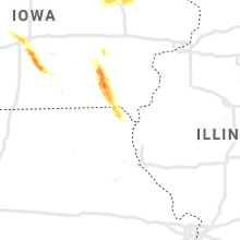
Cities Most Affected by Hail Storms of 6/22/2021
| Hail Size | Demographics of Zip Codes Affected | ||||||
|---|---|---|---|---|---|---|---|
| City | Count | Average | Largest | Pop Density | House Value | Income | Age |
| Osceola, NE | 2 | 1.88 | 2.00 | 5 | $61k | $37.8k | 45.0 |
| Meadow Grove, NE | 2 | 1.75 | 1.75 | 4 | $41k | $32.0k | 44.9 |
| Benedict, NE | 1 | 1.75 | 1.75 | 5 | $60k | $42.2k | 45.9 |
| Monroe, NE | 1 | 1.75 | 1.75 | 6 | $63k | $38.6k | 44.7 |
| Waco, NE | 1 | 1.75 | 1.75 | 8 | $56k | $37.7k | 49.4 |
| Pierson, IA | 1 | 1.75 | 1.75 | 9 | $50k | $36.7k | 39.9 |
| Walker, IA | 1 | 1.75 | 1.75 | 20 | $88k | $43.0k | 37.2 |
Hail and Wind Damage Spotted on 6/22/2021
Filter by Report Type:Hail ReportsWind Reports
States Impacted
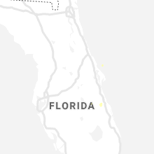
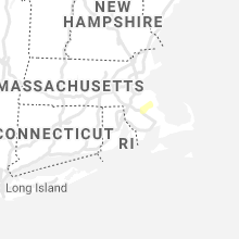
Florida, Rhode Island, Virginia, New Mexico, Massachusetts, Nebraska, Iowa, Idaho, Montana, Missouri, OregonFlorida
| Local Time | Report Details |
|---|---|
| 1:40 PM EDT | A large tree uprooted and fell on top of a house on west 69th street in jacksonville. no injuries. time estimated by rada in duval county FL, 4 miles N of Jacksonville, FL |
Rhode Island
| Local Time | Report Details |
|---|---|
| 2:15 PM EDT | Large branch down on beach ave near west shore roa in kent county RI, 8.6 miles S of Providence, RI |
Virginia
| Local Time | Report Details |
|---|---|
| 2:30 PM EDT | A couple of trees downed along ballard s in york county VA, 40.8 miles NW of Virginia Beach, VA |
| 2:39 PM EDT | Mesonet station xmgl third islan in anz638 county VA, 22.7 miles NW of Virginia Beach, VA |
| 2:45 PM EDT | Trees downed along shell rd. time is radar estimate in city of hampton county VA, 25 miles NW of Virginia Beach, VA |
| 2:51 PM EDT | Mesonet station xplt plantation flat in anz632 county VA, 34.9 miles N of Virginia Beach, VA |
| 2:54 PM EDT | Mesonet station xbbt third islan in anz632 county VA, 19.7 miles N of Virginia Beach, VA |
New Mexico
| Local Time | Report Details |
|---|---|
| 1:01 PM MDT | Klvs aso in san miguel county NM, 57.2 miles SSE of Taos, NM |
Massachusetts
| Local Time | Report Details |
|---|---|
| 3:06 PM EDT | Wires down on locust s in bristol county MA, 21.7 miles ENE of Providence, RI |
| 3:06 PM EDT | Tree down on house on francine r in bristol county MA, 21 miles ENE of Providence, RI |
| 3:06 PM EDT | Tree down on house on francine r in bristol county MA, 21 miles ENE of Providence, RI |
| 3:06 PM EDT | Wires down on locust s in bristol county MA, 21.7 miles ENE of Providence, RI |
| 3:06 PM EDT | Tree down on route 24 southbound near the bridgewater lin in plymouth county MA, 22 miles ENE of Providence, RI |
Nebraska
| Local Time | Report Details |
|---|---|
| 5:00 PM CDT | Quarter sized hail reported near Neligh, NE, 37.8 miles ESE of Oneill, NE, hail covered the ground. |
| 5:20 PM CDT | Ping Pong Ball sized hail reported near Tilden, NE, 50.4 miles ESE of Oneill, NE |
| 5:32 PM CDT | Half Dollar sized hail reported near Meadow Grove, NE, 53.2 miles ESE of Oneill, NE |
| 5:44 PM CDT | Quarter sized hail reported near Meadow Grove, NE, 55.2 miles ESE of Oneill, NE |
| 5:46 PM CDT | Quarter sized hail reported near Meadow Grove, NE, 58 miles ESE of Oneill, NE |
| 5:50 PM CDT | Golf Ball sized hail reported near Meadow Grove, NE, 55.2 miles ESE of Oneill, NE |
| 5:56 PM CDT | Half Dollar sized hail reported near Meadow Grove, NE, 59.2 miles SE of Oneill, NE |
| 6:00 PM CDT | Half Dollar sized hail reported near Meadow Grove, NE, 58.8 miles SE of Oneill, NE |
| 6:00 PM CDT | Golf Ball sized hail reported near Meadow Grove, NE, 58 miles ESE of Oneill, NE |
| 6:19 PM CDT | Half Dollar sized hail reported near Neligh, NE, 38.9 miles SE of Oneill, NE |
| 6:30 PM CDT | Quarter sized hail reported near Madison, NE, 68.3 miles SE of Oneill, NE |
| 7:10 PM CDT | Quarter sized hail reported near Genoa, NE, 54.5 miles NE of Grand Island, NE, also 50-60 mph winds estimated. |
| 7:28 PM CDT | Golf Ball sized hail reported near Monroe, NE, 51.9 miles NE of Grand Island, NE, hail could be even bigger. ongoing. |
| 7:28 PM CDT | Widespread tree damage. power lines blown down. shed destroyed. semi blown ove in platte county NE, 51.9 miles NE of Grand Island, NE |
| 7:30 PM CDT | Quarter sized hail reported near Genoa, NE, 50.9 miles NE of Grand Island, NE, quarter size hail falling at this time. wind gusts estimated to be 50-60 mph at times. |
| 7:30 PM CDT | Reports of tree branches downed in genoa. wind gust reports received were around 75 mph. report of a shed damaged east of genoa... exact location unknown at this tim in nance county NE, 48.2 miles NE of Grand Island, NE |
| 7:34 PM CDT | Quarter sized hail reported near Genoa, NE, 50.3 miles NE of Grand Island, NE |
| 7:41 PM CDT | Ping Pong Ball sized hail reported near Columbus, NE, 53.1 miles NE of Grand Island, NE, hail lasted about 10 minutes. |
| 7:48 PM CDT | Quarter sized hail reported near Columbus, NE, 53.2 miles NE of Grand Island, NE |
| 8:08 PM CDT | Quarter sized hail reported near Osceola, NE, 41.1 miles ENE of Grand Island, NE |
| 8:09 PM CDT | Golf Ball sized hail reported near Osceola, NE, 44.9 miles ENE of Grand Island, NE, hail up to the size of golf balls was reported on the north side of town. |
| 8:09 PM CDT | Hen Egg sized hail reported near Osceola, NE, 44.9 miles ENE of Grand Island, NE, corrects previous hail report from osceola. upon further review observer found some hail to at least 2 inch diameter on the north side of town. |
| 8:10 PM CDT | Quarter sized hail reported near Osceola, NE, 44.6 miles ENE of Grand Island, NE, ongoing on the south side of osceola. |
| 8:13 PM CDT | Half Dollar sized hail reported near Stromsburg, NE, 41.7 miles ENE of Grand Island, NE |
| 8:15 PM CDT | Ping Pong Ball sized hail reported near Stromsburg, NE, 42.7 miles ENE of Grand Island, NE |
| 8:20 PM CDT | Quarter sized hail reported near Stromsburg, NE, 40.9 miles ENE of Grand Island, NE |
| 8:29 PM CDT | Golf Ball sized hail reported near Waco, NE, 44.1 miles E of Grand Island, NE, report via facebook photos. |
| 8:30 PM CDT | Ping Pong Ball sized hail reported near Gresham, NE, 46.1 miles E of Grand Island, NE, quarter to ping pong ball size hail reported. |
| 8:34 PM CDT | Golf Ball sized hail reported near Benedict, NE, 39 miles ENE of Grand Island, NE |
| 8:43 PM CDT | Quarter sized hail reported near Waco, NE, 46.1 miles E of Grand Island, NE |
| 9:08 PM CDT | Half Dollar sized hail reported near Mc Cool Junction, NE, 46.6 miles ESE of Grand Island, NE |
| 9:18 PM CDT | Half Dollar sized hail reported near Friend, NE, 55.3 miles ESE of Grand Island, NE |
| 9:20 PM CDT | Delayed public report of 2-4 inch diameter branches down on hwy 6. relayed by wfo oa in fillmore county NE, 51.6 miles ESE of Grand Island, NE |
| 9:50 PM CDT | Quarter sized hail reported near Hordville, NE, 25.8 miles ENE of Grand Island, NE |
| 9:51 PM CDT | Quarter sized hail reported near Central City, NE, 28.1 miles NE of Grand Island, NE |
| 10:00 PM CDT | Quarter sized hail reported near Hordville, NE, 25.8 miles ENE of Grand Island, NE |
| 10:18 PM CDT | Wind gusts estimated to be near 65 mph... accompanied by pea size hai in york county NE, 29.4 miles E of Grand Island, NE |
| 10:20 PM CDT | Relayed report from dispatch of a semi blown over at mile marker 339 on interstate 80... which is 1 mile east of the hampton exit. no injuries reporte in hamilton county NE, 26.2 miles ESE of Grand Island, NE |
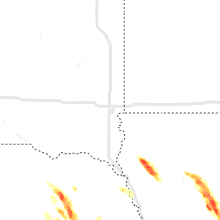
Iowa
| Local Time | Report Details |
|---|---|
| 5:25 PM CDT | Quarter sized hail reported near Grimes, IA, 12.2 miles NW of Des Moines, IA, nickel to quarter size hail. |
| 5:28 PM CDT | Storm damage reported in dallas county IA, 12.7 miles W of Des Moines, IA |
| 5:30 PM CDT | Quarter sized hail reported near Johnston, IA, 7.6 miles NW of Des Moines, IA |
| 5:30 PM CDT | Quarter sized hail reported near Grimes, IA, 11 miles NW of Des Moines, IA, report from mping: quarter (1.00 in.). |
| 5:33 PM CDT | Quarter sized hail reported near Grimes, IA, 12.2 miles NW of Des Moines, IA, time estimated by radar. |
| 5:35 PM CDT | Quarter sized hail reported near Grimes, IA, 8.9 miles WNW of Des Moines, IA, report from mping: quarter (1.00 in.). |
| 5:38 PM CDT | Personal weather statio in dallas county IA, 11.1 miles W of Des Moines, IA |
| 5:38 PM CDT | Quarter sized hail reported near Johnston, IA, 8.1 miles NW of Des Moines, IA, report via social media. |
| 5:39 PM CDT | Quarter sized hail reported near Lytton, IA, 23 miles SE of Storm Lake, IA, mostly pea to nickel size hail with a few quarters mixed in. |
| 5:39 PM CDT | Quarter sized hail reported near Urbandale, IA, 8.2 miles WNW of Des Moines, IA |
| 5:40 PM CDT | Golf Ball sized hail reported near Walker, IA, 22.3 miles NNW of Cedar Rapids, IA |
| 5:42 PM CDT | Quarter sized hail reported near Urbandale, IA, 6 miles NW of Des Moines, IA, report from mping: quarter (1.00 in.). |
| 5:45 PM CDT | Quarter sized hail reported near Urbandale, IA, 8.8 miles WNW of Des Moines, IA, lots of quarter sized hail. |
| 5:45 PM CDT | Ping Pong Ball sized hail reported near Lytton, IA, 23.1 miles SE of Storm Lake, IA |
| 5:46 PM CDT | Quarter sized hail reported near West Des Moines, IA, 5.4 miles W of Des Moines, IA |
| 5:48 PM CDT | Ping Pong Ball sized hail reported near Johnston, IA, 7.6 miles NW of Des Moines, IA, report from mping: ping pong ball (1.50 in.). |
| 5:55 PM CDT | Large tree down along with a utility pol in buchanan county IA, 36.5 miles NNW of Cedar Rapids, IA |
| 5:58 PM CDT | Quarter sized hail reported near Norwalk, IA, 7.7 miles SSW of Des Moines, IA, report from mping: quarter (1.00 in.). |
| 5:59 PM CDT | Quarter sized hail reported near Coggon, IA, 22.2 miles NNE of Cedar Rapids, IA, also winds estimated at 55 mph. |
| 6:05 PM CDT | Quarter sized hail reported near Indianola, IA, 10.7 miles SSE of Des Moines, IA, road is completely covered with dime to quarter size hail along g24 highway near highway 65/69 intersection north of indianola. time estimated by radar. |
| 6:22 PM CDT | Ping Pong Ball sized hail reported near Indianola, IA, 16.1 miles S of Des Moines, IA, quarter to ping pong ball sized hail in indianola. |
| 6:25 PM CDT | Ping Pong Ball sized hail reported near Indianola, IA, 17.1 miles SSE of Des Moines, IA, 1.5 inch hail still along highway 92 east of indianola. occurrence time estimated by radar. |
| 6:30 PM CDT | Quarter sized hail reported near Indianola, IA, 17.9 miles SSE of Des Moines, IA, report from mping: quarter (1.00 in.). |
| 6:31 PM CDT | Ping Pong Ball sized hail reported near Indianola, IA, 17.9 miles SSE of Des Moines, IA, report from mping: ping pong ball (1.50 in.). |
| 6:34 PM CDT | Quarter sized hail reported near Kingsley, IA, 38.2 miles W of Storm Lake, IA, hail of at least quarter size reported. crops severely damaged by hail. |
| 6:38 PM CDT | Quarter sized hail reported near Kingsley, IA, 34.7 miles W of Storm Lake, IA, significant hail damage to crops. |
| 6:40 PM CDT | Ping Pong Ball sized hail reported near Scranton, IA, 54.7 miles SE of Storm Lake, IA, report via social media. time estimated by radar. |
| 6:48 PM CDT | Golf Ball sized hail reported near Pierson, IA, 34.8 miles W of Storm Lake, IA, trained spotter report of golf ball size hail. |
| 6:50 PM CDT | Half Dollar sized hail reported near Bagley, IA, 46.9 miles WNW of Des Moines, IA |
| 6:55 PM CDT | Half Dollar sized hail reported near Correctionville, IA, 31.1 miles WSW of Storm Lake, IA, public report of half dollar size hail. |
| 7:02 PM CDT | Quarter sized hail reported near Bagley, IA, 45.8 miles WNW of Des Moines, IA, dime to quarter hail fell for two to three minutes. |
| 7:16 PM CDT | Quarter sized hail reported near Libertyville, IA, 40.2 miles NNW of Kahoka, MO, pea to quarter sized hail; lasted for 10 to 15 minutes. |
| 7:25 PM CDT | Quarter sized hail reported near Douds, IA, 34 miles NNW of Kahoka, MO, also high winds. |
| 7:40 PM CDT | Quarter sized hail reported near Keosauqua, IA, 29.4 miles NW of Kahoka, MO, occurring right now. 36 mph wind gust. |
Idaho
| Local Time | Report Details |
|---|---|
| 6:55 PM MDT | Mesonet station twbi1 twin butte in owyhee county ID, 38.3 miles WNW of Twin Falls, ID |
| 7:30 PM MDT | Blue spruce tree 50 ft tall uprooted in thunderstorm outflo in canyon county ID, 30.7 miles W of Boise, ID |
| 7:33 PM MDT | 1-inch tree limbs broken; shingles blown of in canyon county ID, 36.3 miles W of Boise, ID |
| 7:41 PM MDT | 1-inch tree limbs broken; shingles blown of in gem county ID, 24.3 miles NW of Boise, ID |
| 7:48 PM MDT | Mesonet station tt682 raws 15 min tx 10 min av in ada county ID, 3.4 miles SSW of Boise, ID |
| 7:58 PM MDT | Asos station kboi bois in ada county ID, 3.2 miles SW of Boise, ID |
| 8:00 PM MDT | Tree broken in half due to thunderstorm outflow winds. estimated 60 mph gus in ada county ID, 9.1 miles WSW of Boise, ID |
| 8:14 PM MDT | Mesonet station tt677 hydromet test in ada county ID, 3.4 miles SSW of Boise, ID |
| 8:14 PM MDT | Mesonet station tt677 hydromet test in ada county ID, 3.4 miles SSW of Boise, ID |
| 8:14 PM MDT | Mesonet station tt677 hydromet test in ada county ID, 3.4 miles SSW of Boise, ID |
| 8:18 PM MDT | Mesonet station ew2058 horseshoe ben in boise county ID, 17.6 miles N of Boise, ID |
| 8:26 PM MDT | Davis weather station. jacobus ranc in gem county ID, 41.8 miles N of Boise, ID |
| 8:28 PM MDT | Mesonet station tt289 crestline trai in ada county ID, 2 miles NE of Boise, ID |
| 8:37 PM MDT | Davis weather statio in elmore county ID, 45.6 miles WNW of Twin Falls, ID |
| 8:44 PM MDT | Mesonet station dehi1 deer have in elmore county ID, 54.7 miles NW of Twin Falls, ID |
| 8:49 PM MDT | A trained spotter reported multiple trees and powerlines down associated with a strong gust front - gusting to around 60 mp in boise county ID, 36 miles NNE of Boise, ID |
| 8:52 PM MDT | Mesonet station deai1 catfis in washington county ID, 69.7 miles NW of Boise, ID |
Montana
| Local Time | Report Details |
|---|---|
| 6:57 PM MDT | Outflow from a decaying thundershower. asos station kdln... dillon airpor in beaverhead county MT, 65.9 miles E of Salmon, ID |
Missouri
| Local Time | Report Details |
|---|---|
| 8:12 PM CDT | Quarter sized hail reported near Luray, MO, 16 miles NW of Kahoka, MO, occurring right now. |
Oregon
| Local Time | Report Details |
|---|---|
| 7:50 PM MDT | Asos station kono ontari in malheur county OR, 50.2 miles NW of Boise, ID |
Connect with Interactive Hail Maps