

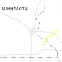
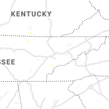
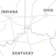
Hail Map for Monday, May 25, 2020

Number of Impacted Households on 5/25/2020
0
Impacted by 1" or Larger Hail
0
Impacted by 1.75" or Larger Hail
0
Impacted by 2.5" or Larger Hail
Square Miles of Populated Area Impacted on 5/25/2020
0
Impacted by 1" or Larger Hail
0
Impacted by 1.75" or Larger Hail
0
Impacted by 2.5" or Larger Hail


Hail and Wind Damage Spotted on 5/25/2020
Filter by Report Type:Hail ReportsWind Reports
States Impacted
Wisconsin, Tennessee, Louisiana, Illinois, Mississippi, Missouri, Kentucky, Arkansas, New York, Texas, Iowa, Oklahoma, West VirginiaWisconsin
| Local Time | Report Details |
|---|---|
| 8:30 AM CDT | Hen Egg sized hail reported near Pepin, WI, 62.2 miles NW of La Crosse, WI, hail size is based on a photo that was reference by a quarter. |
| 8:45 AM CDT | Quarter sized hail reported near Pepin, WI, 65 miles NW of La Crosse, WI |
| 9:10 AM CDT | Quarter sized hail reported near Durand, WI, 66.7 miles NNW of La Crosse, WI, hail lasted 2 minutes. |
| 10:08 AM CDT | Half Dollar sized hail reported near Eau Claire, WI, 71.7 miles NNW of La Crosse, WI |
| 10:10 AM CDT | Quarter sized hail reported near Eau Claire, WI, 72.9 miles NNW of La Crosse, WI |
| 10:11 AM CDT | Corrects previous tstm wnd dmg report from 2 nne eau claire. social media picture of a large tree uprooted near north high school in eau claire. in addition... there wa in eau claire county WI, 72.5 miles N of La Crosse, WI |
| 10:21 AM CDT | Report from mping: trees uprooted or snapped; roof blown of in eau claire county WI, 71.9 miles N of La Crosse, WI |
| 2:59 PM CDT | One tree down blocking the highway near j and j in lincoln county WI, 26.1 miles SW of Rhinelander, WI |
| 4:10 PM CDT | Quarter sized hail reported near Elcho, WI, 20.8 miles SSE of Rhinelander, WI |
Tennessee
| Local Time | Report Details |
|---|---|
| 12:45 PM CDT | Trees down on joppa road with power outages in the area in overton county TN, 75.9 miles WNW of Knoxville, TN |
| 3:20 PM EDT | Few trees down via social media photos; time estimated from rada in hamblen county TN, 30.6 miles ENE of Knoxville, TN |
| 4:11 PM CDT | Large branch off tree near central pike and tulip grove road in hermitage in davidson county TN, 10 miles E of Nashville, TN |
| 4:27 PM CDT | Tree branch on power line on loretta drive in goodlettsville in sumner county TN, 12.5 miles NNE of Nashville, TN |
Louisiana
| Local Time | Report Details |
|---|---|
| 1:16 PM CDT | A power line was downed in wisner and a tree was downed on a parish roa in franklin county LA, 57.1 miles SSE of Bastrop, LA |
| 6:00 PM CDT | Tree reported down near springridge... 4 forks road and springridge driv in caddo county LA, 14.1 miles SSW of Shreveport, LA |
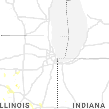
Illinois
| Local Time | Report Details |
|---|---|
| 1:47 PM CDT | Delayed report. grain bin blown in and far outbuilding damaged. images provided via social media. time estimated from rada in warren county IL, 54.1 miles WNW of Peoria, IL |
| 1:48 PM CDT | Delayed report. damage to a barn roof... pictures sent via social media. time estimated from rada in warren county IL, 54.8 miles WNW of Peoria, IL |
| 3:50 PM CDT | A few maple tree limbs down in west frankfort. time approximated by radar at 350 pm cd in franklin county IL, 53.2 miles NE of Cape Girardeau, MO |
| 4:26 PM CDT | Tree branches... several inches thick... snapped off. torrential rainfall causing minor flooding. location between sesser and rend lake on highway 15 in franklin county IL, 61.4 miles NNE of Cape Girardeau, MO |
| 6:25 PM CDT | Several tree limbs were blown down and a patio railing was broken in mason county IL, 27.3 miles SW of Peoria, IL |
| 6:25 PM CDT | Garage damaged and power pole blown down in fulton county IL, 44.1 miles SW of Peoria, IL |
| 6:28 PM CDT | Several 6-10 inch diameter trees uprooted in wet soil condition in fulton county IL, 33.8 miles WSW of Peoria, IL |
| 6:28 PM CDT | Several 6-10 inch diameter trees uprooted in wet soi in fulton county IL, 35.5 miles WSW of Peoria, IL |
| 6:34 PM CDT | Public report of trees... tree limbs... and power lines down. some power poles were leaning. approximate location near hound dog ridge roa in johnson county IL, 31.4 miles ENE of Cape Girardeau, MO |
| 6:37 PM CDT | Media partner shared an image from a spotter of a large tree down. the tree was uprooted and clipped a house. trunk diameter was around 3 fee in macoupin county IL, 64.5 miles NNE of Saint Louis, MO |
| 6:55 PM CDT | Power pole snapped and a large tree branch was blown down in sangamon county IL, 58.2 miles S of Peoria, IL |
| 7:02 PM CDT | Several power poles were pushed over in sangamon county IL, 56.8 miles S of Peoria, IL |
| 8:02 PM CDT | *** 1 inj *** one female was injured by a falling six inch tree branch. several trees and tree branches down across the town of cutler. one tree on power line. branches in perry county IL, 50.9 miles N of Cape Girardeau, MO |
| 8:05 PM CDT | Power line down in peoria county IL, 5.2 miles SW of Peoria, IL |
| 8:05 PM CDT | Power line blown down in peoria county IL, 10.6 miles W of Peoria, IL |
| 8:20 PM CDT | An 8-inch diameter tree limb was blown down in tazewell county IL, 16.4 miles SE of Peoria, IL |
| 8:25 PM CDT | Powerlines were blown down in peoria county IL, 12.6 miles NNW of Peoria, IL |
| 8:28 PM CDT | One tree fell on power line and knocked power out near city limits of eldorado. report time came from saline county 911 offic in saline county IL, 49.9 miles WSW of Evansville, IN |
| 10:00 PM CDT | Tree limbs reported down... with a power line also reported snappe in champaign county IL, 35.6 miles N of Mattoon, IL |
| 10:15 PM CDT | Quarter sized hail reported near Champaign, IL, 43.8 miles N of Mattoon, IL |
| 10:18 PM CDT | Large tree limb reported down onto a fence in champaign county IL, 43.8 miles N of Mattoon, IL |
Mississippi
| Local Time | Report Details |
|---|---|
| 2:22 PM CDT | Tree down across power lines along hwy 2 in warren county MS, 35.7 miles W of Jackson, MS |
| 4:53 PM CDT | Trees down in southeast newton count in newton county MS, 70.3 miles E of Jackson, MS |
| 5:00 PM CDT | Trees and power lines down with damage to building in newton county MS, 67.9 miles E of Jackson, MS |
| 5:08 PM CDT | Tree down near the intersection of 503 and hurst r in newton county MS, 66.3 miles E of Jackson, MS |
| 5:10 PM CDT | Pictures of several trees down and roof damage to an outbuilding between hickory and decatu in newton county MS, 64.7 miles E of Jackson, MS |
Missouri
| Local Time | Report Details |
|---|---|
| 2:33 PM CDT | Sheriff deputy reported strong winds that broke trees and a bar in cooper county MO, 40.4 miles WSW of Columbia, MO |
| 2:56 PM CDT | Modot employee reports tree down over highway k. time estimated from rada in lincoln county MO, 53.7 miles NW of Saint Louis, MO |
| 3:27 PM CDT | Modot employee reports tree down on highway 79 near louisian in pike county MO, 70.8 miles NW of Saint Louis, MO |
| 4:36 PM CDT | 2 to 3 inch tree limbs down. reported by amateur radio operator through emergency manage in grundy county MO, 88.5 miles NE of Kansas City, MO |
| 4:40 PM CDT | Delayed report. large tree limb split near spickard. public report relayed to the office via broadcast medi in grundy county MO, 93.4 miles S of Des Moines, IA |
| 4:56 PM CDT | Delayed reort. several tree branches were down in concordia... along with some minor structural damage. winds were estimated at 60 to 65 mph. time estimated from rada in lafayette county MO, 55.2 miles E of Kansas City, MO |
| 9:51 PM CDT | Large tree top snapped off blocking the road. 400 block of south elm st in granb in newton county MO, 56.6 miles WSW of Springfield, MO |
Kentucky
| Local Time | Report Details |
|---|---|
| 4:10 PM EDT | Tree down that fell on a car. power lines down als in madison county KY, 19.5 miles WSW of Irvine, KY |
| 5:22 PM CDT | Tree dow in logan county KY, 34.3 miles N of Nashville, TN |
| 5:30 PM CDT | Tree down on a house and power lines along hopkinsville roa in logan county KY, 46.4 miles NNW of Nashville, TN |
| 7:30 PM EDT | Tree down on big perry r in rowan county KY, 49.4 miles NE of Irvine, KY |
Arkansas
| Local Time | Report Details |
|---|---|
| 3:55 PM CDT | Tree down in ogde in little river county AR, 27.3 miles SSW of Nashville, AR |
| 3:57 PM CDT | A large tree was blown down on a home. winds from an observation site near town measured between 45 and 50 mph around that tim in randolph county AR, 92.4 miles NNW of Memphis, TN |
| 4:05 PM CDT | Tree reported down west of wilto in little river county AR, 23 miles SW of Nashville, AR |
| 5:28 PM CDT | Thunderstorm winds damaged a chicken house west of men in polk county AR, 53.6 miles NW of Nashville, AR |
| 5:40 PM CDT | Tree down and power lines down on church... tree and power lines on home on murphy street... no injuries reported as of this repor in lafayette county AR, 42.7 miles SSE of Nashville, AR |
| 5:41 PM CDT | Tree and power lines reported down on home on north stree in lafayette county AR, 45.2 miles SSE of Nashville, AR |
| 5:44 PM CDT | Reports of trees down in stamps and lewisvill in lafayette county AR, 43.6 miles SSE of Nashville, AR |
| 5:57 PM CDT | Spotter reports trees snapped and uprooted in the redland communit in nevada county AR, 34.2 miles ESE of Nashville, AR |
| 7:49 PM CDT | Large limbs were blown dow in lonoke county AR, 24.3 miles SE of Little Rock, AR |
| 8:00 PM CDT | A tree was blown down just south of fordyce on highway 8 sout in dallas county AR, 64.5 miles S of Little Rock, AR |
| 8:25 PM CDT | Large tree limb blown down. power outages in the area as wel in pulaski county AR, 8.7 miles NNE of Little Rock, AR |
| 8:41 PM CDT | Several trees were blown down at sherida in grant county AR, 31.2 miles SSW of Little Rock, AR |
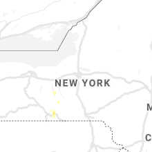
New York
| Local Time | Report Details |
|---|---|
| 6:00 PM EDT | Quarter sized hail reported near Horseheads, NY, 69.5 miles SSW of Syracuse, NY |
| 6:50 PM EDT | Trees down on harris hill roa in chemung county NY, 74.8 miles SSW of Syracuse, NY |
| 6:50 PM EDT | Quarter sized hail reported near Big Flats, NY, 74.4 miles SSW of Syracuse, NY |
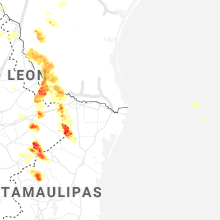
Texas
| Local Time | Report Details |
|---|---|
| 5:13 PM CDT | Multiple trees reported down in and near the mount pleasant area. damage on cr 1230 north of town... trees on some homes... damage to cattle trailer... power poles and in titus county TX, 84.1 miles SW of Nashville, AR |
| 5:43 PM CDT | Quarter sized hail reported near San Augustine, TX, 38.2 miles ENE of Lufkin, TX, report of nickel to quarter-sized hail. |
| 8:18 PM CDT | Ping Pong Ball sized hail reported near Rio Grande City, TX, 89.3 miles WNW of Brownsville, TX, social media public report of ping pong ball size hail. |
| 8:20 PM CDT | Hen Egg sized hail reported near Roma, TX, 83.2 miles SSE of Laredo, TX, reported by roma city police dept. |
| 11:07 PM CDT | Half Dollar sized hail reported near Knippa, TX, 69.8 miles E of Del Rio, TX, report from mping: half dollar (1.25 in.). |
| 11:10 PM CDT | Quarter sized hail reported near Floresville, TX, 29.1 miles SE of San Antonio, TX, quarter size hail reported near sh-97 and us-181. |
| 12:07 AM CDT | Quarter sized hail reported near Runge, TX, 60.5 miles SE of San Antonio, TX, picture of quarter size hail received in runge. |
Iowa
| Local Time | Report Details |
|---|---|
| 5:24 PM CDT | Measured by newton airport awos. time estimate in jasper county IA, 31.5 miles ENE of Des Moines, IA |
| 5:30 PM CDT | Trees down and power poles snapped between newton and kellogg from straight line winds. time estimated from radar. report information relayed from woi... who... and kcc in jasper county IA, 34.6 miles ENE of Des Moines, IA |
| 5:56 PM CDT | Part of machine shed wall and roof blown off. em relayed report from martelle fire chief. time estimated from rada in jones county IA, 16.4 miles E of Cedar Rapids, IA |
| 5:58 PM CDT | Em relayed report from martelle fire chief of a tree down on a home. time estimated from rada in jones county IA, 16.9 miles E of Cedar Rapids, IA |
| 7:13 PM CDT | Unconfirmed report of wind damage in are in polk county IA, 12.5 miles NNW of Des Moines, IA |
| 7:22 PM CDT | Broadcast media relayed public report of 4 inch and 6 inch diameter tree branches down in luxemburg. time estimated from rada in dubuque county IA, 53 miles NE of Cedar Rapids, IA |
| 7:25 PM CDT | Roof of a hog barn was blown off into another hog building causing its roof to collaps in dubuque county IA, 54.4 miles NNE of Cedar Rapids, IA |
Oklahoma
| Local Time | Report Details |
|---|---|
| 5:34 PM CDT | Em reports wind damage to storage facilities and electric lines down near highway 100 on the south edge of tenkiller state park. time is estimated from rada in sequoyah county OK, 37.7 miles WNW of Fort Smith, AR |
| 5:36 PM CDT | Boat storage facility damaged. possible tornado. time is estimated from rada in sequoyah county OK, 35 miles WNW of Fort Smith, AR |
| 6:05 PM CDT | Trees down... county road blocked. time estimated from rada in sequoyah county OK, 19.5 miles WNW of Fort Smith, AR |
| 6:18 PM CDT | Trees down... blocking county road. time estimated from rada in sequoyah county OK, 21.2 miles WNW of Fort Smith, AR |
| 7:37 PM CDT | Ham radio operator reports an estimated wind gust of 70 miles per hou in delaware county OK, 62.2 miles NNW of Fort Smith, AR |
West Virginia
| Local Time | Report Details |
|---|---|
| 7:20 PM EDT | Large tree down on rutledge road... power outage as a result in kanawha county WV, 0.5 miles E of Charleston, WV |
| 7:20 PM EDT | Power lines down on mill creek road in kanawha county WV, 3.4 miles NE of Charleston, WV |
Connect with Interactive Hail Maps