

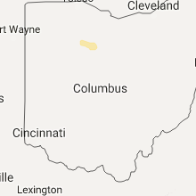
Hail Map for Sunday, October 30, 2016

Number of Impacted Households on 10/30/2016
0
Impacted by 1" or Larger Hail
0
Impacted by 1.75" or Larger Hail
0
Impacted by 2.5" or Larger Hail
Square Miles of Populated Area Impacted on 10/30/2016
0
Impacted by 1" or Larger Hail
0
Impacted by 1.75" or Larger Hail
0
Impacted by 2.5" or Larger Hail
Cities Most Affected by Hail Storms of 10/30/2016
| Hail Size | Demographics of Zip Codes Affected | ||||||
|---|---|---|---|---|---|---|---|
| City | Count | Average | Largest | Pop Density | House Value | Income | Age |
Hail and Wind Damage Spotted on 10/30/2016
Filter by Report Type:Hail ReportsWind Reports
Ohio
| Local Time | Report Details |
|---|---|
| 10:00 AM EDT | Quarter sized hail reported near Carey, OH, 71 miles NNW of Columbus, OH, reported at marathon gas station. nickel to quarter hail lasted for about 4 minutes. time estimated by radar. |
| 10:08 AM EDT | Quarter sized hail reported near Sycamore, OH, 67.6 miles N of Columbus, OH, penny to nickel hail reported by sheriff. officer said hail lasted about 8 minutes. time estimated by radar. |
Pennsylvania
| Local Time | Report Details |
|---|---|
| 4:10 PM EDT | Numerous trees and wires down near camp hill in cumberland county PA, 62.1 miles SE of State College, PA |
| 4:43 PM EDT | Multiple telephone poles down in adams county PA, 44.3 miles NNW of Baltimore, MD |
| 4:55 PM EDT | Widespread trees and wires down on eastman avenue in lancaster county PA, 54 miles NNE of Baltimore, MD |
| 4:55 PM EDT | Multiple trees down in lancaster county PA, 62.3 miles NNE of Baltimore, MD |
| 5:10 PM EDT | Trees and wires blocking route 30 at singer avenue in lancaster county PA, 56.1 miles NNE of Baltimore, MD |
| 5:45 PM EDT | A large number of trees reported down in the berwyn are in chester county PA, 81 miles NE of Baltimore, MD |
| 6:00 PM EDT | Trees and wires dow in montgomery county PA, 71.4 miles SW of Brooklyn, NY |
| 6:00 PM EDT | Trees and wires dow in montgomery county PA, 74.4 miles SW of Brooklyn, NY |
| 6:00 PM EDT | Trees and wires dow in montgomery county PA, 72.7 miles SW of Brooklyn, NY |
Nevada
| Local Time | Report Details |
|---|---|
| 4:00 PM PDT | Spotter estimated 50 mph speed with gusts around 60 mp in humboldt county NV, 13.4 miles E of Winnemucca, NV |
| 4:00 PM PDT | Spotter reported tree down along with 3-5 inch branches snapped of in humboldt county NV, 41.5 miles N of Winnemucca, NV |
| 4:05 PM PDT | Mesonet station rose creek ndot /rsenv in humboldt county NV, 10.8 miles WSW of Winnemucca, NV |
| 4:11 PM PDT | Asos station winnemucca airport asos /wmc in humboldt county NV, 6.4 miles SW of Winnemucca, NV |
| 4:13 PM PDT | Mesonet station carlin tunnel west ndot /ctwnv in elko county NV, 17.7 miles WSW of Elko, NV |
| 4:13 PM PDT | Mesonet station 5 e carlin /ceenv in elko county NV, 15 miles WSW of Elko, NV |
| 4:26 PM PDT | Mesonet station crane springs raws /crsn2 in elko county NV, 26.3 miles S of Elko, NV |
| 4:30 PM PDT | Spotter estimated wind gusts of around 70 mp in elko county NV, 15.7 miles ESE of Elko, NV |
| 4:47 PM PDT | Mesonet station double h raws /tr730 in humboldt county NV, 49.3 miles NNW of Winnemucca, NV |
Idaho
| Local Time | Report Details |
|---|---|
| 7:50 PM MDT | Storm damage reported in butte county ID, 55.4 miles WSW of Idaho Falls, ID |
| 8:00 PM MDT | Radioactive waste management arl sit in butte county ID, 50.7 miles W of Idaho Falls, ID |
| 8:05 PM MDT | Storm damage reported in bingham county ID, 36.6 miles W of Idaho Falls, ID |
| 8:10 PM MDT | Central facilities arl sit in butte county ID, 45.7 miles W of Idaho Falls, ID |
| 8:15 PM MDT | Critical infrastructure complex arl sit in butte county ID, 41.8 miles W of Idaho Falls, ID |
| 8:15 PM MDT | Telegraph hill itd sit in bingham county ID, 27.8 miles W of Idaho Falls, ID |
| 8:20 PM MDT | Material fuesl complex arl sit in bingham county ID, 31.3 miles WNW of Idaho Falls, ID |
| 8:25 PM MDT | Sand dunes arl sit in butte county ID, 41.1 miles WNW of Idaho Falls, ID |
| 8:50 PM MDT | Siding blown off a home. estimated winds at 55mp in power county ID, 63.4 miles SW of Idaho Falls, ID |
| 8:53 PM MDT | Official observation - idaho falls airpor in bonneville county ID, 1.9 miles NW of Idaho Falls, ID |
| 8:55 PM MDT | Rover arl sit in jefferson county ID, 29.1 miles WNW of Idaho Falls, ID |
| 9:14 PM MDT | Estimated up to 60 mph with power flashing off an o in madison county ID, 20.2 miles NNE of Idaho Falls, ID |
| 9:27 PM MDT | Idaho falls pd reporting trees down in the 2000 block of west broadway. power is out als in bonneville county ID, 1.5 miles WNW of Idaho Falls, ID |
| 9:30 PM MDT | Reported via office facebook pag in caribou county ID, 61.8 miles SSE of Idaho Falls, ID |
Connect with Interactive Hail Maps