

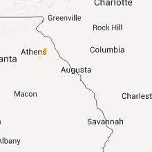
Hail Map for Monday, September 5, 2011

Number of Impacted Households on 9/5/2011
0
Impacted by 1" or Larger Hail
0
Impacted by 1.75" or Larger Hail
0
Impacted by 2.5" or Larger Hail
Square Miles of Populated Area Impacted on 9/5/2011
0
Impacted by 1" or Larger Hail
0
Impacted by 1.75" or Larger Hail
0
Impacted by 2.5" or Larger Hail

Cities Most Affected by Hail Storms of 9/5/2011
| Hail Size | Demographics of Zip Codes Affected | ||||||
|---|---|---|---|---|---|---|---|
| City | Count | Average | Largest | Pop Density | House Value | Income | Age |
| Indian Trail, NC | 1 | 1.75 | 1.75 | 759 | $127k | $54.9k | 35.5 |
Hail and Wind Damage Spotted on 9/5/2011
Filter by Report Type:Hail ReportsWind Reports
States Impacted
Alabama, Georgia, Florida, Virginia, North Carolina, South Carolina, New Hampshire, Arizona, CaliforniaAlabama
| Local Time | Report Details |
|---|---|
| 12:47 PM UTC | Several large tree limbs down on zirlott roa in mobile county AL, 8.2 miles W of Mobile, AL |
| 1:25 PM UTC | Wind gust measured at exit 30 on interstate 1 in mobile county AL, 3.4 miles ESE of Mobile, AL |
| 3:28 PM UTC | Dauphin island c-man station recorded a gust of 63 mp in gmz650 county AL, 30.1 miles S of Mobile, AL |
| 3:37 PM UTC | Trees were reported down along county ro in lee county AL, 13.3 miles SSE of Auburn, AL |
| 4:05 PM UTC | Possible tornado reported near intersection of highway 25 and county road 85. trees reported down and roof was off a bar in hale county AL, 58.2 miles NNW of Camden, AL |
| 4:07 PM UTC | Trees and powerlines were knocked down in several locations across op in lee county AL, 6.6 miles ENE of Auburn, AL |
| 7:05 PM UTC | Few trees down around the county in geneva county AL, 54 miles NNE of Miramar Beach, FL |
| 7:24 PM UTC | Trees and power lines down in the logan road area around ozar in dale county AL, 82 miles NNE of Miramar Beach, FL |
| 7:35 PM UTC | Tree down on south union avenue in ozar in dale county AL, 80.4 miles S of Auburn, AL |
| 7:47 PM UTC | Trees down on county road 15 near skipperville in dale county AL, 72.3 miles S of Auburn, AL |
| 7:50 PM UTC | Estimated winds at least 60 mph near highway 134 in dale county AL, 83.2 miles NE of Miramar Beach, FL |
| 7:53 PM UTC | Tree down on a house with injuries on ross clark circle s in houston county AL, 81.9 miles NE of Miramar Beach, FL |
| 8:14 PM UTC | 2 trees down near abbevill in henry county AL, 72.8 miles S of Auburn, AL |
| 9:03 PM UTC | Trees down around the area from another stor in geneva county AL, 54 miles NNE of Miramar Beach, FL |
| 11:03 PM UTC | Trees down around hodgesvill in houston county AL, 76.4 miles NE of Miramar Beach, FL |
Georgia
| Local Time | Report Details |
|---|---|
| 4:30 PM UTC | Haralson county 911 relayed a report of at least half a dozen downed tree in haralson county GA, 39.1 miles W of Atlanta, GA |
| 6:38 PM UTC | Harris county relayed reports of 3 downed trees in mulberry grov in harris county GA, 30.6 miles E of Auburn, AL |
| 7:04 PM UTC | Several trees down along west bluffton road in clay county GA, 76.7 miles SSE of Auburn, AL |
| 7:05 PM UTC | *** 1 inj *** trees and power lines down county wide. update...woman struck by falling limb in hunt cam in randolph county GA, 70.5 miles SE of Auburn, AL |
| 7:05 PM UTC | Trees and power lines down county wid in randolph county GA, 70.5 miles SE of Auburn, AL |
| 7:13 PM UTC | Cherokee county emergency management relayed a report of hwy 92 blocked by downed trees and debri in cherokee county GA, 25.7 miles NNW of Atlanta, GA |
| 7:19 PM UTC | Amateur radio relayed reports of multiple downed trees in the area of bascom and carmel roads west of interstate 575 in cherokee count in cherokee county GA, 30 miles NNW of Atlanta, GA |
| 7:21 PM UTC | Cherokee county emergency management relayed a report of damage along sixes road near holly spring in cherokee county GA, 29.2 miles NNW of Atlanta, GA |
| 7:30 PM UTC | Public reported several trees down on wedgewood falls drive. power lines were also downe in cherokee county GA, 34.4 miles N of Atlanta, GA |
| 7:30 PM UTC | Public reports several trees downed along river estates pkw in cherokee county GA, 34.4 miles N of Atlanta, GA |
| 7:31 PM UTC | Cherokee county emergency management relayed reports of major damage in ne canton as tornado crossed hwy 2 in cherokee county GA, 35 miles N of Atlanta, GA |
| 7:35 PM UTC | Public reported several trees down on wedgewood falls drive. power lines were also downe in cherokee county GA, 34.4 miles N of Atlanta, GA |
| 7:38 PM UTC | Cobb county 911 relayed reports of 3-4 downed tree in cobb county GA, 27.7 miles NW of Atlanta, GA |
| 7:47 PM UTC | Carroll county emergency management relayed reports of 3-4 downed trees in the count in carroll county GA, 38.7 miles WSW of Atlanta, GA |
| 7:48 PM UTC | Public reported 20 trees downed...canapy and awning off house...roof off barn and shed...and crushed vehicles and fence in cherokee county GA, 40.8 miles N of Atlanta, GA |
| 7:50 PM UTC | Numerous trees down on the east side of the county. 2 houses damaged along marble hill church road south of tat in pickens county GA, 44.9 miles N of Atlanta, GA |
| 7:51 PM UTC | Amateur radio relayed reports of multiple trees down along hwy 5 in pickens county GA, 46.4 miles N of Atlanta, GA |
| 7:55 PM UTC | Tree down on spring hill roa in grady county GA, 37.3 miles N of Tallahassee, FL |
| 8:00 PM UTC | Public reports numerous trees and power lines down. a house had a tree downed onto it along mcray driv in cherokee county GA, 34.4 miles N of Atlanta, GA |
| 8:02 PM UTC | Jones county 911 relayed reports of 5 downed trees and 4-5 downed powerlines in the time from 400 pm to 600 p in jones county GA, 76.7 miles SE of Atlanta, GA |
| 8:05 PM UTC | Union county 911 relayed a report of a downed tre in union county GA, 68.6 miles NNE of Atlanta, GA |
| 8:10 PM UTC | One tree blown on burnt mountain road...one tree down on clear creek road and one tree down on big creek roa in gilmer county GA, 55.3 miles N of Atlanta, GA |
| 8:18 PM UTC | Trees down around the count in baker county GA, 60.7 miles N of Tallahassee, FL |
| 8:18 PM UTC | Trees down around the county and including downtown pelha in mitchell county GA, 48.2 miles N of Tallahassee, FL |
| 8:19 PM UTC | Trees down in the eastern part of the count in lowndes county GA, 60.4 miles SSW of Douglas, GA |
| 8:20 PM UTC | Muscogee county 911 relayed reports of several downed trees and line in muscogee county GA, 30.4 miles ESE of Auburn, AL |
| 8:20 PM UTC | Pickens county emergency management relayed reports of 3 closed roads due to numerous downed trees and powerlines. possible tornado damag in pickens county GA, 45.8 miles N of Atlanta, GA |
| 8:24 PM UTC | 3 trees down along 8 mile roa in dougherty county GA, 75.8 miles N of Tallahassee, FL |
| 8:24 PM UTC | Fire department reports trees down across several roadways in riceboro. time estimated based on rada in liberty county GA, 30.8 miles SW of Savannah, GA |
| 8:24 PM UTC | Power lines down in thomasvill in thomas county GA, 32.9 miles NNE of Tallahassee, FL |
| 8:28 PM UTC | Paulding county emergency management relayed reports of several downed tree in paulding county GA, 23.1 miles WNW of Atlanta, GA |
| 8:30 PM UTC | Tree down near the intersection of harvest ln and phillips d in dougherty county GA, 77.9 miles N of Tallahassee, FL |
| 8:30 PM UTC | Tree down near 2500 east double gat in dougherty county GA, 79.2 miles N of Tallahassee, FL |
| 8:33 PM UTC | Fire department reports trees down across roadways in midway. time estimated basd on rada in liberty county GA, 26.8 miles SW of Savannah, GA |
| 8:33 PM UTC | Tree down on south main street. time estimated by rada in liberty county GA, 34.2 miles WSW of Savannah, GA |
| 8:33 PM UTC | Large oak tree down on ashmore street. time estimated by rada in liberty county GA, 34.7 miles WSW of Savannah, GA |
| 8:33 PM UTC | Tree down on ola-b lane. time estimated by rada in liberty county GA, 26.1 miles SW of Savannah, GA |
| 8:35 PM UTC | Tree fell on house on third street. time estimated by rada in liberty county GA, 33.3 miles WSW of Savannah, GA |
| 8:35 PM UTC | Tree fell on vehicle on west general stewart way. time estimated by rada in liberty county GA, 33.6 miles WSW of Savannah, GA |
| 8:36 PM UTC | Tree down at highway 17 north and sand dollar drive. time estimated by rada in liberty county GA, 24.6 miles SW of Savannah, GA |
| 8:40 PM UTC | Lumpkin county 911 relayed reports of 1-2 downed tree in lumpkin county GA, 57.8 miles NNE of Atlanta, GA |
| 8:40 PM UTC | Few trees down in the western part of the count in lee county GA, 81.1 miles WNW of Douglas, GA |
| 8:41 PM UTC | Trees down around the count in lanier county GA, 40 miles SSW of Douglas, GA |
| 8:45 PM UTC | Emergency manager reported a few trees and power lines down to the northeast of statenville. time is estimated and based on radar imager in echols county GA, 48.6 miles S of Douglas, GA |
| 8:46 PM UTC | Pine tree down in richmond hill. time estimated based on rada in bryan county GA, 15.7 miles SW of Savannah, GA |
| 8:46 PM UTC | Bartow county 911 relayed reports of over a dozen downed trees in the county so far through the even in bartow county GA, 45.8 miles NW of Atlanta, GA |
| 8:51 PM UTC | Few power lines down along highway 62 wes in early county GA, 76.6 miles NNW of Tallahassee, FL |
| 9:03 PM UTC | Awning on a store blown off in worth county GA, 52.6 miles W of Douglas, GA |
| 9:08 PM UTC | Garden city fire reports trees and powerlines dow in chatham county GA, 4.8 miles WNW of Savannah, GA |
| 9:10 PM UTC | Emergency manager reported a few trees and power lines down in the homerville vicinity. time is estimated and based on radar imager in clinch county GA, 32.6 miles S of Douglas, GA |
| 9:25 PM UTC | Madison county 911 relayed reports of 2 downed trees in comer along hwy 7 in madison county GA, 61.1 miles SSW of Greenville, SC |
| 9:26 PM UTC | Tree down in tift county GA, 39.2 miles W of Douglas, GA |
| 9:50 PM UTC | Trees reported down on douglas highway. time estimated by rada in jeff davis county GA, 29.1 miles NNE of Douglas, GA |
| 9:55 PM UTC | Trees down countywide in brooks county GA, 49.2 miles ENE of Tallahassee, FL |
| 10:01 PM UTC | One tree fell on a mobile hom in hart county GA, 38.1 miles SSW of Greenville, SC |
| 10:50 PM UTC | Whitfield county emergency management relayed a report of a tree downed onto a house causing heavy structural damag in whitfield county GA, 21.2 miles ESE of Chattanooga, TN |
| 10:50 PM UTC | Whitfield county emergency management relayed a report of a tree downed onto a house causing structural damag in whitfield county GA, 21.2 miles ESE of Chattanooga, TN |
| 12:15 AM UTC | Tree limbs down over western parts of echols county. power still out to a number of residents due to tree limbs falling on power lines. time estimated based on rada in echols county GA, 56.9 miles SSW of Douglas, GA |
| 12:57 AM UTC | Trees and power lines down along highway 112 near camill in mitchell county GA, 54.6 miles N of Tallahassee, FL |
Florida
| Local Time | Report Details |
|---|---|
| 4:31 PM UTC | Hurlbert field /fmq-19/ sensor on runway 36...recorded a gust of 65 mp in okaloosa county FL, 18 miles W of Miramar Beach, FL |
| 4:31 PM UTC | Numerous small with a few large tree limbs down on elgin air force base near the burger kin in okaloosa county FL, 18 miles W of Miramar Beach, FL |
| 4:45 PM UTC | Pine tree reported blown down onto a house on wadsworth blv in okaloosa county FL, 34.9 miles NNW of Miramar Beach, FL |
| 4:47 PM UTC | Pensacola regional airport recorded a gust of 59 mp in escambia county FL, 49.9 miles W of Miramar Beach, FL |
| 5:45 PM UTC | Large oak tree blown over by strong wind gusts doing significant damage to a hom in okaloosa county FL, 10.4 miles NW of Miramar Beach, FL |
| 5:45 PM UTC | Several large tree limbs down across escambia count in escambia county FL, 51.4 miles W of Miramar Beach, FL |
| 6:30 PM UTC | Power lines down near highway 20 between business 331 and the 331 bypas in walton county FL, 16.4 miles ENE of Miramar Beach, FL |
| 6:30 PM UTC | Trees down near the intersection of bond drive and cosson roa in walton county FL, 23 miles NNE of Miramar Beach, FL |
| 6:33 PM UTC | Several trees down around 6120 bob sikes roa in walton county FL, 24.4 miles NNE of Miramar Beach, FL |
| 6:33 PM UTC | Tree on power line near 5687 s us 33 in walton county FL, 24.1 miles NE of Miramar Beach, FL |
| 6:33 PM UTC | Widespread tree damage in walton county FL, 25.4 miles NE of Miramar Beach, FL |
| 6:34 PM UTC | Trees down around 2644 bob sikes roa in walton county FL, 25.7 miles NNE of Miramar Beach, FL |
| 6:35 PM UTC | Tree down on power line near 288 county highway 83a in walton county FL, 27.8 miles NNE of Miramar Beach, FL |
| 6:41 PM UTC | Trees down around 7140 us highway 33 in walton county FL, 31.9 miles NNE of Miramar Beach, FL |
| 6:52 PM UTC | 2 trees down along interstate 1 in holmes county FL, 34.6 miles NE of Miramar Beach, FL |
| 6:52 PM UTC | 2 trees down on highway 81 north of ponce de leon in holmes county FL, 37.8 miles NE of Miramar Beach, FL |
| 6:53 PM UTC | Spotter estimated winds of 60 to 70 mph with power lines down in bay county FL, 32.6 miles ESE of Miramar Beach, FL |
| 6:58 PM UTC | 52 knot wind gust at kecp airport in bay county FL, 33.5 miles E of Miramar Beach, FL |
| 7:28 PM UTC | Trees down county wid in washington county FL, 56.3 miles ENE of Miramar Beach, FL |
| 7:55 PM UTC | Few trees down around madison including marion street...horry avenue...and washington street. also large palm tree broken 15 feet of in madison county FL, 51.4 miles E of Tallahassee, FL |
| 7:55 PM UTC | Few trees down around madison including marion street...horry avenue...and washington street in madison county FL, 51.4 miles E of Tallahassee, FL |
| 8:01 PM UTC | Trees down and traffic lights ou in leon county FL, 9.7 miles NNE of Tallahassee, FL |
| 8:01 PM UTC | Trees down around bull run and kerry forest pkw in leon county FL, 7.5 miles NNE of Tallahassee, FL |
| 8:06 PM UTC | Trees and power lines down in hamilton county FL, 65.5 miles E of Tallahassee, FL |
| 8:24 PM UTC | Duke field /egi/ asos recorded a gust of 63 mp in okaloosa county FL, 21.2 miles NNW of Miramar Beach, FL |
| 8:30 PM UTC | Trees down from a new round of storm in walton county FL, 27.8 miles NNE of Miramar Beach, FL |
| 8:46 PM UTC | Trees and power lines down in the eastern part of the count in wakulla county FL, 17.6 miles SSE of Tallahassee, FL |
| 9:03 PM UTC | Power lines down around the count in lafayette county FL, 69.4 miles ESE of Tallahassee, FL |
| 9:08 PM UTC | Trees down in the southern part of the count in jefferson county FL, 24 miles SE of Tallahassee, FL |
| 9:09 PM UTC | Few trees down in the last hour around the count in jackson county FL, 60.3 miles NW of Tallahassee, FL |
| 9:13 PM UTC | Trees down around capps in jefferson county FL, 22.2 miles E of Tallahassee, FL |
| 9:24 PM UTC | Powerlines down along barnes road in jefferson county FL, 27.7 miles ENE of Tallahassee, FL |
| 9:53 PM UTC | Tree down in columbia county FL, 59.7 miles W of Jacksonville, FL |
| 9:55 PM UTC | Tree down in gilchrist county FL, 85.7 miles SW of Jacksonville, FL |
| 10:10 PM UTC | Tree down in washington county FL, 42.6 miles NE of Miramar Beach, FL |
| 10:20 PM UTC | Trees down near high springs. time estimated based on rada in alachua county FL, 65.8 miles WSW of Jacksonville, FL |
| 11:50 PM UTC | Tree reported down near thurgood marshall middle school. time estimated from radar...report delaye in pinellas county FL, 18.8 miles NNW of Bradenton, FL |
| 12:00 AM UTC | Power line down near henderson farm in madison county FL, 58.6 miles E of Tallahassee, FL |
Virginia
| Local Time | Report Details |
|---|---|
| 4:40 PM UTC | Tree down on emmanuel road near conner grove roa in floyd county VA, 42 miles SW of Roanoke, VA |
| 11:05 PM UTC | Tree down on a power line and also fell on a house on harris hollow roa in floyd county VA, 39.2 miles SW of Roanoke, VA |
| 11:25 PM UTC | Tree down on woods gap roa in floyd county VA, 32.8 miles SW of Roanoke, VA |
| 11:34 PM UTC | One large tree fell and took down two power lines on grove street in wythe county VA, 59.5 miles WSW of Roanoke, VA |
| 12:57 AM UTC | One tree down on route 43 just south of bedford in bedford county VA, 23.4 miles E of Roanoke, VA |
| 2:11 AM UTC | Thunderstorm winds blew trees downa across route 52 between hillsville and can in carroll county VA, 60 miles SW of Roanoke, VA |
| 3:15 AM UTC | Tree down on union school roa in floyd county VA, 38.4 miles SW of Roanoke, VA |
North Carolina
| Local Time | Report Details |
|---|---|
| 8:01 PM UTC | One tree down on route 88 near laurel springs in ashe county NC, 54.4 miles ESE of Bristol, TN |
| 8:19 PM UTC | One tree down on pine swamp road in alleghany county NC, 62.1 miles E of Bristol, TN |
| 8:24 PM UTC | One tree down on glade valley road along route 21 in alleghany county NC, 65.7 miles E of Bristol, TN |
| 11:10 PM UTC | A few trees and limbs down at tuckaseegee park. time is based on when strongest storm passed over this location. nobody was around on labor day to see this occu in mecklenburg county NC, 4 miles WNW of Charlotte, NC |
| 7:50 PM EDT | Golf Ball sized hail reported near Indian Trail, NC, 17.1 miles SE of Charlotte, NC, up to golf ball sized hail reported at porter ridge high school in indian |
| 11:54 PM UTC | In addition to the previously reported damage to barns and tin roofs on ridge road near c.j. thomas road...there were also trees down in the are in union county NC, 19.9 miles ESE of Charlotte, NC |
| 7:59 PM EDT | Quarter sized hail reported near Monroe, NC, 16.2 miles SE of Charlotte, NC, sardis church and unionville indian road. |
| 12:35 AM UTC | Powerlines blown down 1200 marble roa in mecklenburg county NC, 4.4 miles NW of Charlotte, NC |
| 12:47 AM UTC | Tree down on snuggs park road in stanly county NC, 37.5 miles ENE of Charlotte, NC |
| 1:15 AM UTC | Tree down on elk creek darby road in wilkes county NC, 57.4 miles SE of Bristol, TN |
| 2:06 AM UTC | One tree down on flippin road in stokes county NC, 57 miles SSW of Roanoke, VA |
| 2:06 AM UTC | One tree down on moore road in stokes county NC, 54.7 miles SSW of Roanoke, VA |
| 10:25 AM UTC | Tree down on highway 18. also power went out at about this time in part of the are in alleghany county NC, 71.8 miles E of Bristol, TN |
| 11:07 AM UTC | Tree down on a power line on n saylor street in moore county NC, 59.3 miles SW of Raleigh, NC |
South Carolina
| Local Time | Report Details |
|---|---|
| 9:19 PM UTC | Trees down on interstate 26 east of newberr in newberry county SC, 61 miles NNE of Augusta, GA |
| 9:20 PM UTC | Trees and powerlines down on bluff roa in allendale county SC, 51.9 miles SE of Augusta, GA |
| 9:22 PM UTC | Tree down on becks ferry rd near hwy 32 in jasper county SC, 17.9 miles N of Savannah, GA |
| 9:25 PM UTC | Trees and powerlines down on bostick roa in allendale county SC, 52.1 miles SE of Augusta, GA |
| 9:34 PM UTC | Tree down at us hwy 321 and sc 33 in jasper county SC, 26.2 miles N of Savannah, GA |
| 9:36 PM UTC | Highway patrol reports powerlines in roadway on us278 in klin in barnwell county SC, 44.3 miles SE of Augusta, GA |
| 9:36 PM UTC | Trees down on highway 278 just outside of the town of klin in barnwell county SC, 43.9 miles ESE of Augusta, GA |
| 9:36 PM UTC | Tree down at tillman rd and tarboro r in jasper county SC, 27.2 miles N of Savannah, GA |
| 10:00 PM UTC | Highway patrol reports debris in roadway near intersection of sc 37 and 39. time based on rada in barnwell county SC, 37.9 miles E of Augusta, GA |
| 10:14 PM UTC | Trees down on dean swamp church road about 2 miles north of sc highway 4 in aiken county SC, 36.9 miles E of Augusta, GA |
| 10:22 PM UTC | Trees down near the intersection of clay hill rd and younce rd just east of pelio in lexington county SC, 49.8 miles ENE of Augusta, GA |
| 10:45 PM UTC | Trees down near the intersection of beards creek circle and island trail in lexington county SC, 59.2 miles NE of Augusta, GA |
| 10:50 PM UTC | Trees down at intersection of 1700 block of fairlamb avenue and percival road in richland county SC, 72.9 miles ENE of Augusta, GA |
| 11:00 PM UTC | Enforcement highway patrol reports trees down on sc215 at wallaceville roa in fairfield county SC, 66.8 miles NE of Augusta, GA |
| 11:19 PM UTC | One tree down near salem crossroads near sr 34 and sr 21 in fairfield county SC, 61.2 miles SSW of Charlotte, NC |
| 12:14 AM UTC | Tree down in york county SC, 32.9 miles SW of Charlotte, NC |
| 12:14 AM UTC | Tree down in rock hil in york county SC, 22.3 miles SSW of Charlotte, NC |
| 12:14 AM UTC | Tree down in york county SC, 16.8 miles SW of Charlotte, NC |
| 12:14 AM UTC | Tree down kelly road and hwy 4 in york county SC, 29.6 miles SW of Charlotte, NC |
New Hampshire
| Local Time | Report Details |
|---|---|
| 11:00 PM UTC | Six rvs destroyed and six damaged. wind gust estimated at 60 mph in merrimack county NH, 74.7 miles WSW of Portland, ME |
Arizona
| Local Time | Report Details |
|---|---|
| 11:05 PM UTC | Box truck blown in yuma county AZ, 12.3 miles ENE of Yuma, AZ |
| 11:25 PM UTC | Roof partially blown off shed in yuma county AZ, 9.2 miles E of Yuma, AZ |
California
| Local Time | Report Details |
|---|---|
| 11:15 PM UTC | Relayed by amateur radio. roof damage to in imperial county CA, 3.1 miles N of Yuma, AZ |
Connect with Interactive Hail Maps