

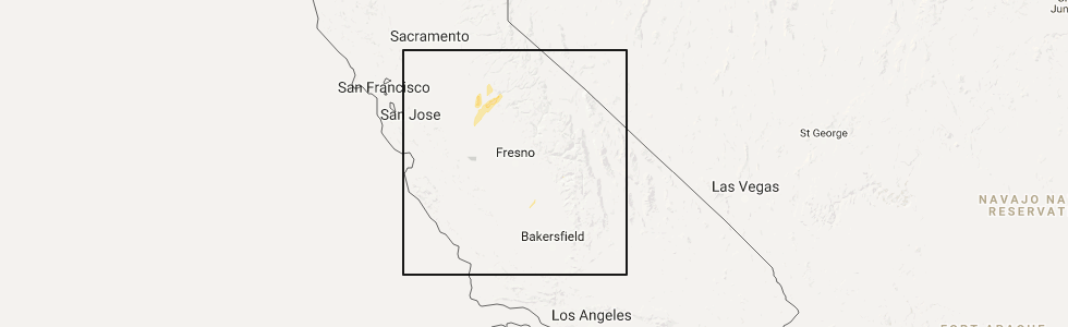
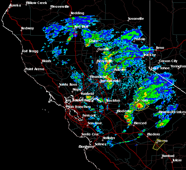
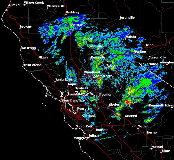
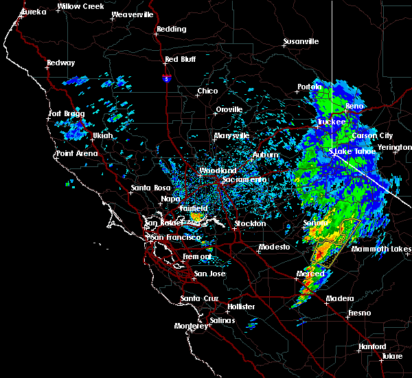
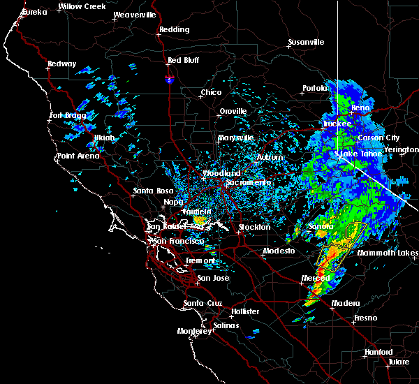
Hail Map for Greeley Hill, CA
The Greeley Hill, CA area has had 0 reports of on-the-ground hail by trained spotters, and has been under severe weather warnings 0 times during the past 12 months. Doppler radar has detected hail at or near Greeley Hill, CA on 1 occasion.
| Name: | Greeley Hill, CA |
| Where Located: | 73.1 miles NNW of Fresno, CA |
| Map: | Google Map for Greeley Hill, CA |
| Population: | 915 |
| Housing Units: | 631 |
| More Info: | Search Google for Greeley Hill, CA |
5
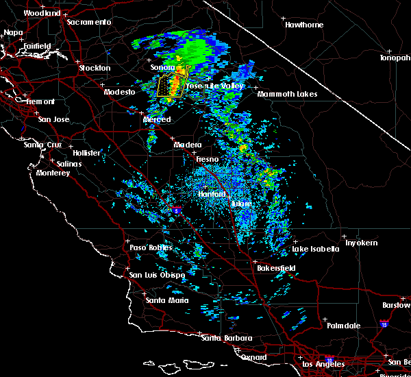
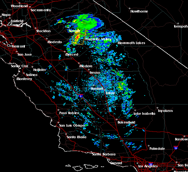
The Top Recent Hail Date for Greeley Hill, CA is Tuesday, March 21, 2017 (1st out of 1)
Hail and Wind Damage Spotted near Greeley Hill, CA
| Date / Time | Report Details |
|---|---|
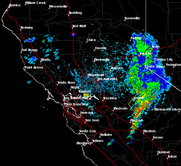
| 3/6/2019 4:26 PM PST |
 At 422 pm pst, a line of strong thunderstorms, a few possibly severe, were detected over northwestern mariposa county. the storms are forecast to weaken, however strong damaging winds and penny sized hail is still possible with some of these storms. additionally, heavy rain accompanying these storms can produce flash flooding (radar indicated). Hazards include 60 mph wind gusts are possible. Large hail and damaging winds are still possible with these storms. the storms will move eastward over the ferguson burn scar shortly. 0. 75in <50mph. At 422 pm pst, a line of strong thunderstorms, a few possibly severe, were detected over northwestern mariposa county. the storms are forecast to weaken, however strong damaging winds and penny sized hail is still possible with some of these storms. additionally, heavy rain accompanying these storms can produce flash flooding (radar indicated). Hazards include 60 mph wind gusts are possible. Large hail and damaging winds are still possible with these storms. the storms will move eastward over the ferguson burn scar shortly. 0. 75in <50mph.
|
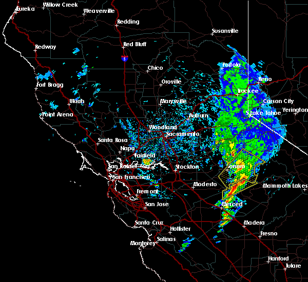
| 3/6/2019 4:03 PM PST |
 At 401 pm pst, a few severe thunderstorms were located 7 miles south of smith station, or 25 miles southeast of sonora, moving northeast at 40 mph (radar indicated). Hazards include 60 mph wind gusts and quarter size hail. Hail damage to vehicles is expected. expect wind damage to roofs, siding, and possibly fallen trees. heavy rain associated with these thunderstorms can cause flooding or flash flooding. This severe thunderstorm will remain over mainly rural areas of northwestern mariposa and southern tuolumne counties. At 401 pm pst, a few severe thunderstorms were located 7 miles south of smith station, or 25 miles southeast of sonora, moving northeast at 40 mph (radar indicated). Hazards include 60 mph wind gusts and quarter size hail. Hail damage to vehicles is expected. expect wind damage to roofs, siding, and possibly fallen trees. heavy rain associated with these thunderstorms can cause flooding or flash flooding. This severe thunderstorm will remain over mainly rural areas of northwestern mariposa and southern tuolumne counties.
|
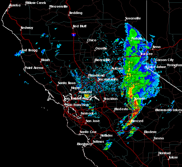
| 3/6/2019 3:32 PM PST |
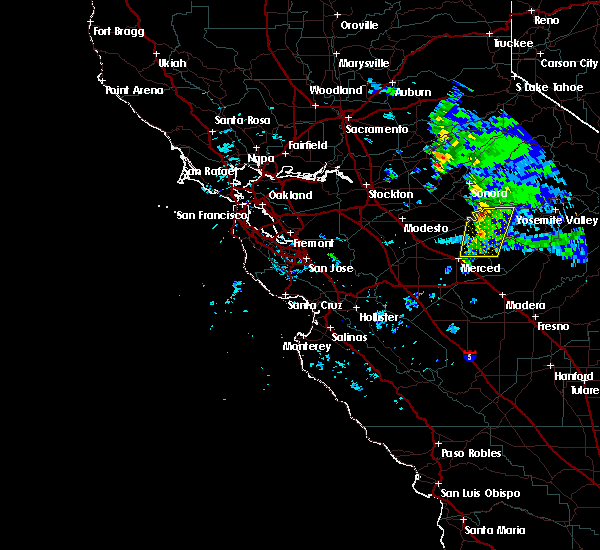 At 330 pm pst, a line of strong thunderstorms, a few at severe levels, extended from northwestern mariposa county into eastern merced county just east of merced. the line was moving east at about 25 mph (radar indicated). Hazards include 60 mph wind gusts and quarter size hail along with very heavy rain and possible flooding. any of these storms could spawn a funnel cloud. Hail damage to vehicles is expected. Expect wind damage to roofs, siding, and trees. At 330 pm pst, a line of strong thunderstorms, a few at severe levels, extended from northwestern mariposa county into eastern merced county just east of merced. the line was moving east at about 25 mph (radar indicated). Hazards include 60 mph wind gusts and quarter size hail along with very heavy rain and possible flooding. any of these storms could spawn a funnel cloud. Hail damage to vehicles is expected. Expect wind damage to roofs, siding, and trees.
|
| 3/6/2019 2:09 PM PST |
 At 208 pm pst, a severe thunderstorm was located near moccasin, or 9 miles south of sonora, moving northeast at 25 mph (radar indicated). Hazards include quarter size hail or larger. Damage to vehicles is expected. Locations impacted include, sonora, chinese camp, smith station, phoenix lake-cedar, groveland-big oak flat, mono vista, groveland-big oak, phoenix lake-cedar ridge, east sonora, tuolumne city, soulsbyville, buck meadows fs and twain harte. At 208 pm pst, a severe thunderstorm was located near moccasin, or 9 miles south of sonora, moving northeast at 25 mph (radar indicated). Hazards include quarter size hail or larger. Damage to vehicles is expected. Locations impacted include, sonora, chinese camp, smith station, phoenix lake-cedar, groveland-big oak flat, mono vista, groveland-big oak, phoenix lake-cedar ridge, east sonora, tuolumne city, soulsbyville, buck meadows fs and twain harte.
|
| 3/6/2019 1:55 PM PST |
 At 154 pm pst, a severe thunderstorm was located near chinese camp, or 13 miles south of sonora, moving northeast at 25 mph (radar indicated). Hazards include quarter size hail. damage to vehicles is expected At 154 pm pst, a severe thunderstorm was located near chinese camp, or 13 miles south of sonora, moving northeast at 25 mph (radar indicated). Hazards include quarter size hail. damage to vehicles is expected
|
| 3/21/2017 3:27 PM PDT |
 The severe thunderstorm warning for central tuolumne county will expire at 330 pm pdt, the storm which prompted the warning has weakened below severe limits, and no longer poses an immediate threat to life or property. therefore the warning will be allowed to expire. The severe thunderstorm warning for central tuolumne county will expire at 330 pm pdt, the storm which prompted the warning has weakened below severe limits, and no longer poses an immediate threat to life or property. therefore the warning will be allowed to expire.
|
| 3/21/2017 3:14 PM PDT |
 At 314 pm pdt, doppler radar indicated a severe thunderstorm capable of producing large hail up to ping pong ball size and damaging winds in excess of 60 mph. this storm was located 10 miles south of smith station, or 26 miles southeast of sonora, and moving east northeast at 30 mph. At 314 pm pdt, doppler radar indicated a severe thunderstorm capable of producing large hail up to ping pong ball size and damaging winds in excess of 60 mph. this storm was located 10 miles south of smith station, or 26 miles southeast of sonora, and moving east northeast at 30 mph.
|
| 3/21/2017 3:00 PM PDT |
 At 3 pm pdt, doppler radar continued to indicate a severe thunderstorm capable of producing quarter size hail and damaging winds in excess of 60 mph. trained spotters have reported abundant small hail in mono vista, groveland, and twain harte with this storm. this storm was located over pinecrest, or 18 miles southwest of sonora pass, moving northeast at 25 mph. locations impacted include, sonora, pinecrest, jupiter, long barn, smith station, phoenix lake- cedar, mi-wuk village, twain harte, groveland- big oak flat, mono vista, buck meadows fs, groveland- big oak, phoenix lake- cedar ridge, east sonora, tuolumne city, soulsbyville and columbia. At 3 pm pdt, doppler radar continued to indicate a severe thunderstorm capable of producing quarter size hail and damaging winds in excess of 60 mph. trained spotters have reported abundant small hail in mono vista, groveland, and twain harte with this storm. this storm was located over pinecrest, or 18 miles southwest of sonora pass, moving northeast at 25 mph. locations impacted include, sonora, pinecrest, jupiter, long barn, smith station, phoenix lake- cedar, mi-wuk village, twain harte, groveland- big oak flat, mono vista, buck meadows fs, groveland- big oak, phoenix lake- cedar ridge, east sonora, tuolumne city, soulsbyville and columbia.
|
| 3/21/2017 2:44 PM PDT |
 At 243 pm pdt, doppler radar indicated a severe thunderstorm capable of producing large hail up to ping pong ball size and damaging winds in excess of 60 mph. this storm was located over smith station, or 18 miles southeast of sonora, and moving east northeast at 35 mph. At 243 pm pdt, doppler radar indicated a severe thunderstorm capable of producing large hail up to ping pong ball size and damaging winds in excess of 60 mph. this storm was located over smith station, or 18 miles southeast of sonora, and moving east northeast at 35 mph.
|
| 3/21/2017 2:29 PM PDT |
 At 228 pm pdt, doppler radar indicated a severe thunderstorm capable of producing quarter size hail and damaging winds in excess of 60 mph. this storm was located 7 miles southeast of cedar ridge, or 10 miles east of sonora, and moving northeast at 25 mph. At 228 pm pdt, doppler radar indicated a severe thunderstorm capable of producing quarter size hail and damaging winds in excess of 60 mph. this storm was located 7 miles southeast of cedar ridge, or 10 miles east of sonora, and moving northeast at 25 mph.
|
| 3/21/2017 2:21 PM PDT |
 At 220 pm pdt, doppler radar continued to indicate a severe thunderstorm capable of producing quarter size hail and damaging winds in excess of 60 mph. this storm was located near smith station, or 17 miles southeast of sonora, moving northeast at 45 mph. locations impacted include, lake mcclure. At 220 pm pdt, doppler radar continued to indicate a severe thunderstorm capable of producing quarter size hail and damaging winds in excess of 60 mph. this storm was located near smith station, or 17 miles southeast of sonora, moving northeast at 45 mph. locations impacted include, lake mcclure.
|
| 3/21/2017 2:16 PM PDT |
 At 215 pm pdt, doppler radar indicated a severe thunderstorm capable of producing damaging winds in excess of 60 mph. this storm was located 10 miles southwest of smith station, or 20 miles south of sonora, and moving east northeast at 35 mph. At 215 pm pdt, doppler radar indicated a severe thunderstorm capable of producing damaging winds in excess of 60 mph. this storm was located 10 miles southwest of smith station, or 20 miles south of sonora, and moving east northeast at 35 mph.
|
Hail Maps for Greeley Hill, CA
Connect with Interactive Hail Maps