

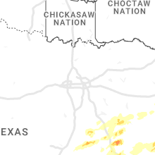
Hail Map for Sunday, April 28, 2024

Number of Impacted Households on 4/28/2024
0
Impacted by 1" or Larger Hail
0
Impacted by 1.75" or Larger Hail
0
Impacted by 2.5" or Larger Hail
Square Miles of Populated Area Impacted on 4/28/2024
0
Impacted by 1" or Larger Hail
0
Impacted by 1.75" or Larger Hail
0
Impacted by 2.5" or Larger Hail


Cities Most Affected by Hail Storms of 4/28/2024
| Hail Size | Demographics of Zip Codes Affected | ||||||
|---|---|---|---|---|---|---|---|
| City | Count | Average | Largest | Pop Density | House Value | Income | Age |
| Crockett, TX | 1 | 1.75 | 1.75 | 26 | $49k | $27.1k | 42.4 |
| Madisonville, TX | 1 | 1.75 | 1.75 | 35 | $56k | $28.2k | 36.0 |
Hail and Wind Damage Spotted on 4/28/2024
Filter by Report Type:Hail ReportsWind Reports
Texas
| Local Time | Report Details |
|---|---|
| 7:10 AM CDT | Picture of snapped power pole shared by a utility company on social media. street view is of around the 1600 block of w. stassney l in travis county TX, 62.6 miles S of Killeen, TX |
| 8:05 AM CDT | Wind damage with large tree snapped at manchaca and wm cannon r in travis county TX, 63.3 miles S of Killeen, TX |
| 8:09 AM CDT | Several downed trees and tree damage within garrison park. time estimated via rada in travis county TX, 62.6 miles S of Killeen, TX |
| 8:10 AM CDT | Corrects previous tstm wnd dmg report from 1 se sunset valley. picture of snapped power pole shared by a utility company on social media. street view is of around the 1 in travis county TX, 62.6 miles S of Killeen, TX |
| 8:35 AM CDT | Emergency manager sent pictures of a billboard blown over and an ac unit blown off the roof of a convenience store in manor. time estimated from rada in travis county TX, 53.8 miles S of Killeen, TX |
| 8:39 AM CDT | Roof damage to a home near shadow glenn elementary. time estimated via rada in travis county TX, 53.3 miles SSE of Killeen, TX |
| 1:10 PM CDT | Quarter sized hail reported near Floresville, TX, 28.6 miles SE of San Antonio, TX, trained spotter reports quarter sized hail near the intersection of highways 97 and 181. |
| 1:45 PM CDT | Quarter sized hail reported near Poth, TX, 35 miles SE of San Antonio, TX, public reports quarter sized hail near the intersection of highway 181 and westmeyer street. |
| 1:50 PM CDT | Quarter sized hail reported near Poth, TX, 35 miles SE of San Antonio, TX, quarter sized hail at the poth fire department. |
| 3:02 PM CDT | Half Dollar sized hail reported near Groesbeck, TX, 76.3 miles ENE of Killeen, TX, hail of 1 to 1.25 inches. relayed by emergency management. |
| 4:58 PM CDT | Quarter sized hail reported near Jewett, TX, 84.1 miles W of Lufkin, TX, trained spotter reports via amateur radio of quarter sized hail. |
| 5:24 PM CDT | Multiple trees were blown down across the northern and central sections of cherokee count in cherokee county TX, 52.6 miles NW of Lufkin, TX |
| 5:45 PM CDT | A 59 mph wind gusts recorded at lake striker from texas water development board mesonet station. also... rusk coounty em reports tree down on 15000 black of cr 4255 in in cherokee county TX, 45.5 miles NNW of Lufkin, TX |
| 5:55 PM CDT | Tree across fm road 1798 at w fork angelina river... west of laneville communit in rusk county TX, 44.8 miles NNW of Lufkin, TX |
| 5:57 PM CDT | Tree down 10500 fm road 839 south... near county road 45 in rusk county TX, 48.4 miles NNW of Lufkin, TX |
| 5:59 PM CDT | Emergency manager reports large tree down on fm road 840 near pecan creek and on fm road 13 just inside loop 571. both in the city of henderso in rusk county TX, 56.5 miles N of Lufkin, TX |
| 6:12 PM CDT | Several power poles reported down across town per city marshall and county e in rusk county TX, 39.2 miles N of Lufkin, TX |
| 6:14 PM CDT | Multiple trees down on fm 1798 near pine hill communit in rusk county TX, 52.6 miles N of Lufkin, TX |
| 6:15 PM CDT | Golf Ball sized hail reported near Crockett, TX, 57.7 miles W of Lufkin, TX, golf ball sized hail was observed along cr 3180. |
| 6:21 PM CDT | Three power poles downed approximately two miles west of bedia in grimes county TX, 79.8 miles NNW of Houston, TX |
| 6:21 PM CDT | Power lines and trees were downed in and around the bedias area... along fm 1696... cr 125 and cr 11 in grimes county TX, 77.7 miles NNW of Houston, TX |
| 6:35 PM CDT | A tree was blown down onto a home in carthag in panola county TX, 42.8 miles SW of Shreveport, LA |
| 6:35 PM CDT | Numerous trees and power lines dow in marion county TX, 39 miles WNW of Shreveport, LA |
| 6:35 PM CDT | Trees and power lines dow in cherokee county TX, 40.5 miles NW of Lufkin, TX |
| 6:42 PM CDT | Numerous trees were downed throughout northern panola count in panola county TX, 28.4 miles WSW of Shreveport, LA |
| 6:56 PM CDT | Trees and power lines dow in shelby county TX, 43.4 miles NNE of Lufkin, TX |
| 7:00 PM CDT | Trees and power lines dow in cass county TX, 37.5 miles NW of Shreveport, LA |
| 7:06 PM CDT | Golf Ball sized hail reported near Madisonville, TX, 81 miles WSW of Lufkin, TX, golf ball sized hail was observed in the cottonwood area. |
| 7:19 PM CDT | Tree downed on highway 90 south of madisonvill in madison county TX, 77.2 miles WSW of Lufkin, TX |
| 8:03 PM CDT | Trees dow in nacogdoches county TX, 26.8 miles NNE of Lufkin, TX |
| 8:05 PM CDT | *** 2 inj *** home damaged in the rock creek subdivision off of fm 356 west of sebastopol. two injuries reported. time estimated on radar and subject to chang in trinity county TX, 46 miles SW of Lufkin, TX |
| 8:25 PM CDT | Large tree on road at intersection of fm road 3135 at county road 33 in rusk county TX, 58.4 miles WSW of Shreveport, LA |
| 8:30 PM CDT | Trees dow in panola county TX, 30.7 miles SW of Shreveport, LA |
| 8:30 PM CDT | Multiple trees were downed across nacogdoches count in nacogdoches county TX, 22 miles NNE of Lufkin, TX |
| 8:45 PM CDT | Wind gust occurred at a tempest weather system sit in madison county TX, 71.7 miles WSW of Lufkin, TX |
| 8:56 PM CDT | Trees and power lines dow in shelby county TX, 43.4 miles NNE of Lufkin, TX |
| 9:10 PM CDT | A tree was downed along cr 381 southeast of martinsvill in nacogdoches county TX, 27.7 miles NE of Lufkin, TX |
| 9:25 PM CDT | Several large trees were downed on highway 9 in trinity county TX, 28.2 miles SW of Lufkin, TX |
| 9:33 PM CDT | Multiple trees and power lines were downed across shelby count in shelby county TX, 40.7 miles NE of Lufkin, TX |
| 9:35 PM CDT | Corrects previous tstm wnd dmg report from timpson. trees and power lines dow in shelby county TX, 43.4 miles NNE of Lufkin, TX |
| 10:06 PM CDT | Multiple trees were downed across angelina count in angelina county TX, 9.2 miles ESE of Lufkin, TX |
| 10:42 PM CDT | A tree was blown down across fm 2558 near broaddu in san augustine county TX, 26.7 miles E of Lufkin, TX |
| 10:47 PM CDT | A tree was blown down across fm 711 just northwest of san augustin in san augustine county TX, 37 miles ENE of Lufkin, TX |
| 10:49 PM CDT | Trees were blown down on fm 2213 just south of san augustin in san augustine county TX, 36.6 miles ENE of Lufkin, TX |
| 11:30 PM CDT | A tree was blown down across highway 83 just west of pineland near bear creek. a car drove into the tree and crashed... but fortunately... there were no injurie in sabine county TX, 41.8 miles E of Lufkin, TX |
| 11:40 PM CDT | Tree down on rr255 between colmesneil and hwy 6 in tyler county TX, 34.2 miles SE of Lufkin, TX |
| 12:05 AM CDT | Trees down on hwy 190 near dam b. time estimated by rada in tyler county TX, 45 miles SE of Lufkin, TX |
| 4:10 AM CDT | Half Dollar sized hail reported near Orange, TX, 12.2 miles NW of Beaumont, TX, public reports a little bigger than quarters. this was on the edge of the core. |
Missouri
| Local Time | Report Details |
|---|---|
| 10:00 AM CDT | Sac osage electric cooperative reported multiple broken poles resulting in a power outag in cedar county MO, 61.2 miles NW of Springfield, MO |
| 8:22 PM CDT | Delayed report. tree down on home on k highway south of union city. time estimated from rada in stone county MO, 19.2 miles SSW of Springfield, MO |
| 8:22 PM CDT | Trees down at state highways k and m in cleve in stone county MO, 18.6 miles SSW of Springfield, MO |
Oklahoma
| Local Time | Report Details |
|---|---|
| 5:33 PM CDT | Storm damage reported in tulsa county OK, 4.3 miles ESE of Tulsa, OK |
| 5:43 PM CDT | Quarter sized hail reported near Owasso, OK, 11.5 miles NE of Tulsa, OK, 76th and us 169. |
| 5:45 PM CDT | Damage to business signs. flag poles bent in parking lo in tulsa county OK, 11.5 miles NE of Tulsa, OK |
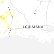
Louisiana
| Local Time | Report Details |
|---|---|
| 7:02 PM CDT | At least two trees were downed across woolworth road near walnut hill middle schoo in caddo county LA, 12.9 miles SW of Shreveport, LA |
| 7:05 PM CDT | Multiple trees down along shirley francis road near woolworth roa in caddo county LA, 11.5 miles SW of Shreveport, LA |
| 7:10 PM CDT | Reported at kdtn...downtown shreveport airport aso in bossier county LA, 1.8 miles NNE of Shreveport, LA |
| 7:10 PM CDT | Trees snapped on tynneside way in south shrevepor in caddo county LA, 9.8 miles SSW of Shreveport, LA |
| 7:14 PM CDT | Reported at kshv...shreveport regional airport aso in caddo county LA, 6.6 miles SW of Shreveport, LA |
| 7:23 PM CDT | Trees were downed in stonewal in de soto county LA, 17.4 miles SSW of Shreveport, LA |
| 7:50 PM CDT | Emergency manager reports several trees down on roadways across tow in webster county LA, 37.4 miles NNE of Shreveport, LA |
| 8:15 PM CDT | Trees and power lines dow in claiborne county LA, 46.8 miles NE of Shreveport, LA |
| 1:49 AM CDT | Asos station kaex alexandri in rapides county LA, 83.2 miles NNW of Lafayette, LA |
Arkansas
| Local Time | Report Details |
|---|---|
| 7:30 PM CDT | A power pole was snapped with a power line pulled out of a home at mm 6 on highway 71 sout in miller county AR, 42.7 miles NNW of Shreveport, LA |
| 7:31 PM CDT | Trees down on highway 160 just past cr 195 east of doddridg in miller county AR, 40.4 miles N of Shreveport, LA |
| 7:43 PM CDT | Power poles and lines down on cr 246 on the south end of lake erlin in lafayette county AR, 38.2 miles NNE of Shreveport, LA |
| 7:43 PM CDT | Highway 71 is blocked due to several trees dow in miller county AR, 48.9 miles S of Nashville, AR |
| 7:45 PM CDT | Arkansas state highway 160 east of bradley is blocked with trees dow in lafayette county AR, 40.8 miles N of Shreveport, LA |
| 8:48 PM CDT | Powerlines reported down on smackover roa in ouachita county AR, 65.5 miles ESE of Nashville, AR |
| 8:51 PM CDT | Police dispatch reports that deputies report powerlines down on fort lookout acr in ouachita county AR, 63.3 miles ESE of Nashville, AR |
| 9:11 PM CDT | Power outages with lines down along owley road south of mt. id in montgomery county AR, 40.7 miles NNE of Nashville, AR |
| 9:28 PM CDT | Fordyce police dispatch reports that power is out to most of the town of fordyce due to severe winds that moved across the tow in dallas county AR, 65.2 miles S of Little Rock, AR |
Connect with Interactive Hail Maps