

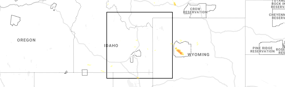
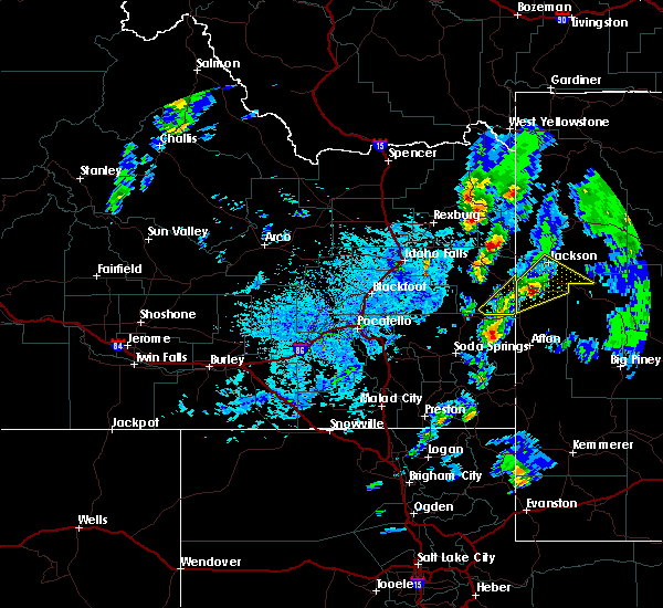
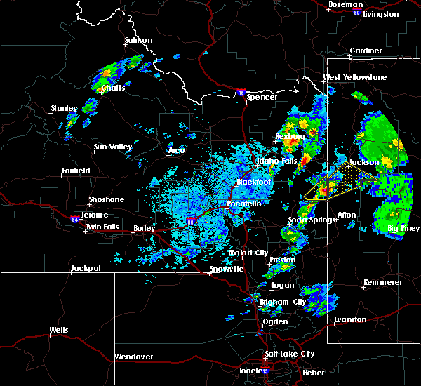
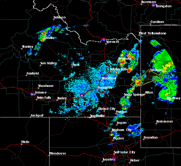
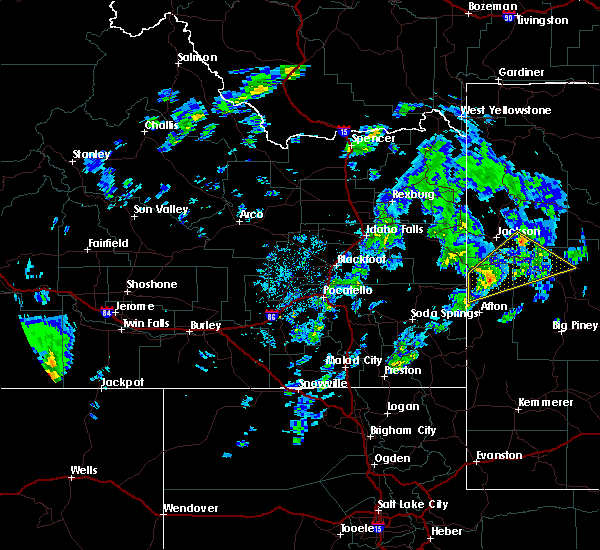
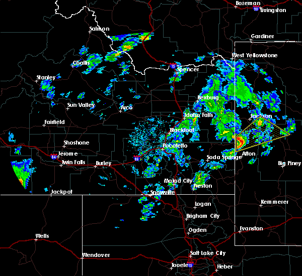
Hail Map for Hoback, WY
The Hoback, WY area has had 0 reports of on-the-ground hail by trained spotters, and has been under severe weather warnings 2 times during the past 12 months. Doppler radar has detected hail at or near Hoback, WY on 6 occasions, including 1 occasion during the past year.
| Name: | Hoback, WY |
| Where Located: | 67.6 miles E of Idaho Falls, ID |
| Map: | Google Map for Hoback, WY |
| Population: | 1176 |
| Housing Units: | 567 |
| More Info: | Search Google for Hoback, WY |
1
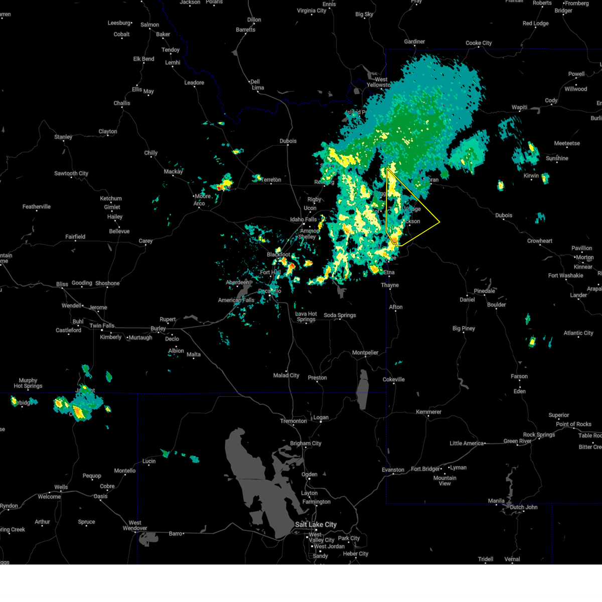
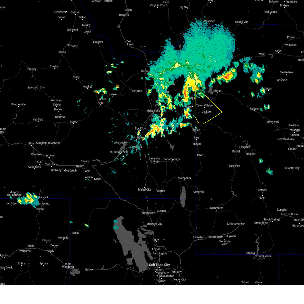
The Top Recent Hail Date for Hoback, WY is Sunday, August 6, 2023 (5th out of 6)
Hail and Wind Damage Spotted near Hoback, WY
| Date / Time | Report Details |
|---|---|
| 7/1/2023 6:26 PM MDT |
 The severe thunderstorm warning for southwestern teton county will expire at 630 pm mdt, the storm which prompted the warning has weakened below severe limits, and no longer poses an immediate threat to life or property. therefore, the warning will be allowed to expire. however gusty winds are still possible with this thunderstorm. The severe thunderstorm warning for southwestern teton county will expire at 630 pm mdt, the storm which prompted the warning has weakened below severe limits, and no longer poses an immediate threat to life or property. therefore, the warning will be allowed to expire. however gusty winds are still possible with this thunderstorm.
|
| 7/1/2023 5:58 PM MDT |
 At 558 pm mdt, a severe thunderstorm was located near victor, which is also 7 miles southeast of driggs, moving southeast at 45 mph (radar indicated). Hazards include 60 mph wind gusts. Expect damage to roofs, siding, and trees. this severe thunderstorm will be near, rendezvous peak around 605 pm mdt. teton village and teton pass around 610 pm mdt. wilson around 615 pm mdt. other locations in the path of this severe thunderstorm include jackson and rafter j ranch. hail threat, radar indicated max hail size, <. 75 in wind threat, observed max wind gust, 60 mph. At 558 pm mdt, a severe thunderstorm was located near victor, which is also 7 miles southeast of driggs, moving southeast at 45 mph (radar indicated). Hazards include 60 mph wind gusts. Expect damage to roofs, siding, and trees. this severe thunderstorm will be near, rendezvous peak around 605 pm mdt. teton village and teton pass around 610 pm mdt. wilson around 615 pm mdt. other locations in the path of this severe thunderstorm include jackson and rafter j ranch. hail threat, radar indicated max hail size, <. 75 in wind threat, observed max wind gust, 60 mph.
|
| 7/20/2017 3:24 PM MDT |
 At 323 pm mdt, a severe thunderstorm was located near hoback, which is 13 miles northeast of alpine, moving east at 30 mph (radar indicated). Hazards include 60 mph wind gusts and quarter size hail. Hail damage to vehicles is expected. expect wind damage to roofs, siding, and trees. this severe thunderstorm will be near, hoback around 335 pm mdt. bondurant and granite falls hot springs around 415 pm mdt. Other locations impacted by this severe thunderstorm include station creek campground, hoback campground, east elbow campground, granite creek campground, east table creek campground, kozy campground and cabin creek campground. At 323 pm mdt, a severe thunderstorm was located near hoback, which is 13 miles northeast of alpine, moving east at 30 mph (radar indicated). Hazards include 60 mph wind gusts and quarter size hail. Hail damage to vehicles is expected. expect wind damage to roofs, siding, and trees. this severe thunderstorm will be near, hoback around 335 pm mdt. bondurant and granite falls hot springs around 415 pm mdt. Other locations impacted by this severe thunderstorm include station creek campground, hoback campground, east elbow campground, granite creek campground, east table creek campground, kozy campground and cabin creek campground.
|
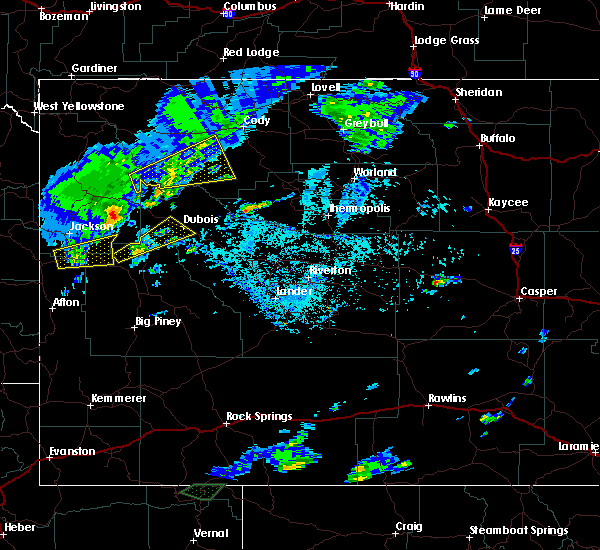
| 8/7/2016 1:58 PM MDT | The severe thunderstorm warning for southwestern teton and northwestern lincoln counties will expire at 200 pm mdt, the storm which prompted the warning has moved out of the area. therefore, the warning will be allowed to expire. however small hail is still possible in the northern star valley as another strong storms moves in. |
| 8/7/2016 1:43 PM MDT |
 At 143 pm mdt, a severe thunderstorm was located 8 miles southwest of hoback, or 9 miles northeast of alpine, moving northeast at 35 mph (radar indicated). Hazards include 60 mph wind gusts and quarter size hail. Hail damage to vehicles is expected. expect wind damage to roofs, siding, and trees. This severe storm will be near, hoback and rafter j ranch around 200 pm mdt. At 143 pm mdt, a severe thunderstorm was located 8 miles southwest of hoback, or 9 miles northeast of alpine, moving northeast at 35 mph (radar indicated). Hazards include 60 mph wind gusts and quarter size hail. Hail damage to vehicles is expected. expect wind damage to roofs, siding, and trees. This severe storm will be near, hoback and rafter j ranch around 200 pm mdt.
|
| 8/7/2016 1:30 PM MDT |
 At 129 pm mdt, a severe thunderstorm was located over alpine, moving northeast at 30 mph (radar indicated). Hazards include ping pong ball size hail and 60 mph wind gusts. People and animals outdoors will be injured. expect hail damage to roofs, siding, windows, and vehicles. expect wind damage to roofs, siding, and trees. This severe storm will be near, hoback around 200 pm mdt. At 129 pm mdt, a severe thunderstorm was located over alpine, moving northeast at 30 mph (radar indicated). Hazards include ping pong ball size hail and 60 mph wind gusts. People and animals outdoors will be injured. expect hail damage to roofs, siding, windows, and vehicles. expect wind damage to roofs, siding, and trees. This severe storm will be near, hoback around 200 pm mdt.
|
| 8/7/2016 1:19 PM MDT |
 At 118 pm mdt, a severe thunderstorm was located near alpine, moving northeast at 35 mph (radar indicated). Hazards include 60 mph wind gusts and half dollar size hail. Hail damage to vehicles is expected. expect wind damage to roofs, siding, and trees. This severe thunderstorm will be near, hoback around 155 pm mdt. At 118 pm mdt, a severe thunderstorm was located near alpine, moving northeast at 35 mph (radar indicated). Hazards include 60 mph wind gusts and half dollar size hail. Hail damage to vehicles is expected. expect wind damage to roofs, siding, and trees. This severe thunderstorm will be near, hoback around 155 pm mdt.
|
| 7/10/2016 1:03 PM MDT |
 At 102 pm mdt, a severe thunderstorm was located 11 miles east of stewart peak, which is 15 miles east of alpine, moving northeast at 55 mph (trained weather spotters). Hazards include 60 mph wind gusts and quarter size hail. Hail damage to vehicles is expected. expect wind damage to roofs, siding and trees. this severe storm will be near, bondurant around 120 pm mdt. granite falls hot springs around 125 pm mdt. Other locations impacted by this severe thunderstorm include etna, thayne, granite creek campground, cedar creek golf course and wolf creek campground. At 102 pm mdt, a severe thunderstorm was located 11 miles east of stewart peak, which is 15 miles east of alpine, moving northeast at 55 mph (trained weather spotters). Hazards include 60 mph wind gusts and quarter size hail. Hail damage to vehicles is expected. expect wind damage to roofs, siding and trees. this severe storm will be near, bondurant around 120 pm mdt. granite falls hot springs around 125 pm mdt. Other locations impacted by this severe thunderstorm include etna, thayne, granite creek campground, cedar creek golf course and wolf creek campground.
|
| 7/10/2016 12:55 PM MDT |
 At 1254 pm mdt, a severe thunderstorm was located near stewart peak, which is 11 miles southeast of alpine, moving northeast at 55 mph (radar indicated). Hazards include 60 mph wind gusts and quarter size hail. Hail damage to vehicles is expected. expect wind damage to roofs, siding and trees. this severe thunderstorm will be near, bondurant around 120 pm mdt. granite falls hot springs around 125 pm mdt. Other locations impacted by this severe thunderstorm include etna, thayne, cedar creek golf course and wolf creek campground. At 1254 pm mdt, a severe thunderstorm was located near stewart peak, which is 11 miles southeast of alpine, moving northeast at 55 mph (radar indicated). Hazards include 60 mph wind gusts and quarter size hail. Hail damage to vehicles is expected. expect wind damage to roofs, siding and trees. this severe thunderstorm will be near, bondurant around 120 pm mdt. granite falls hot springs around 125 pm mdt. Other locations impacted by this severe thunderstorm include etna, thayne, cedar creek golf course and wolf creek campground.
|
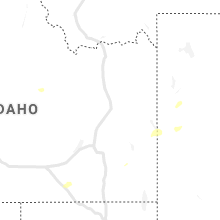
Hail Maps for Hoback, WY


Connect with Interactive Hail Maps