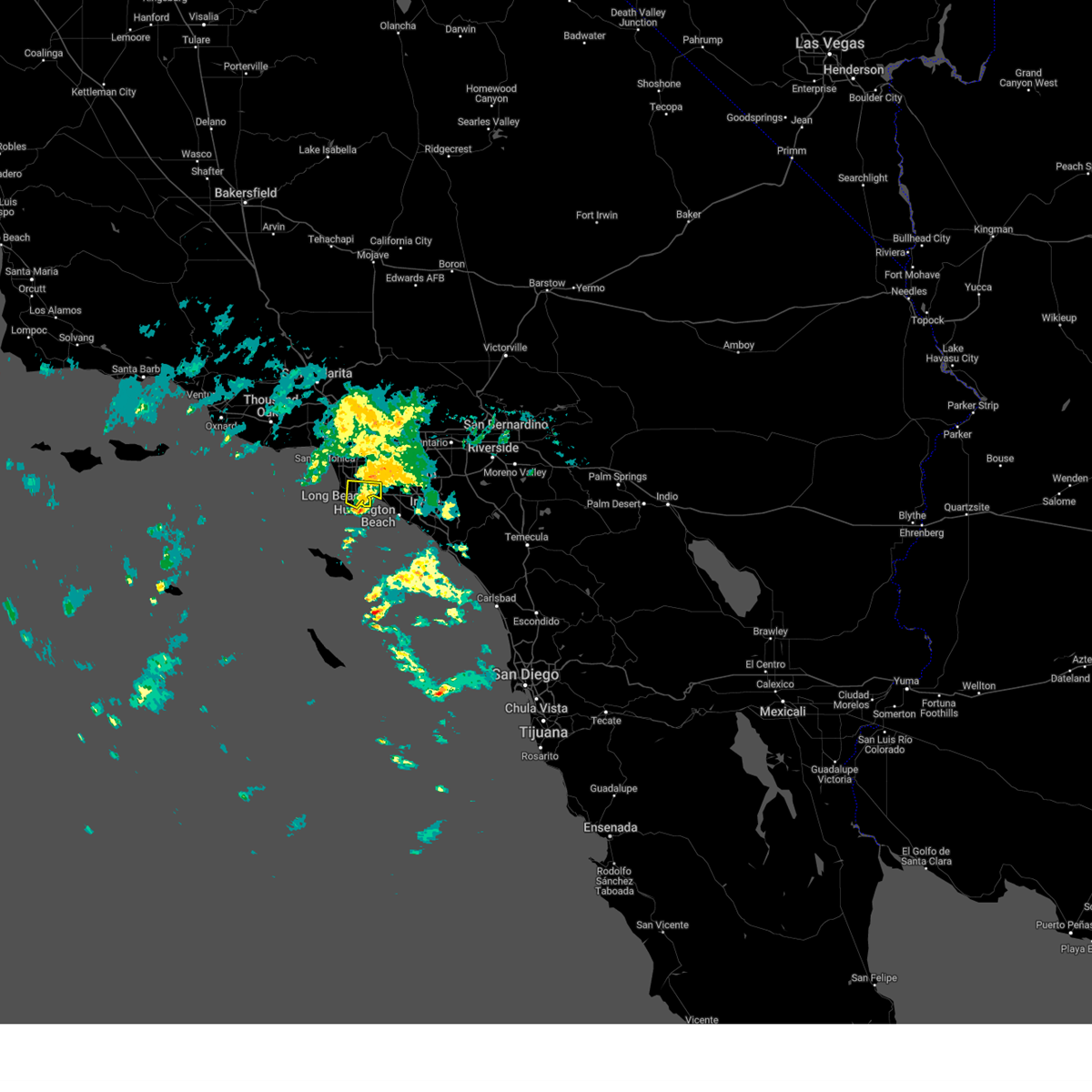
| 3/31/2024 1:18 AM PDT |
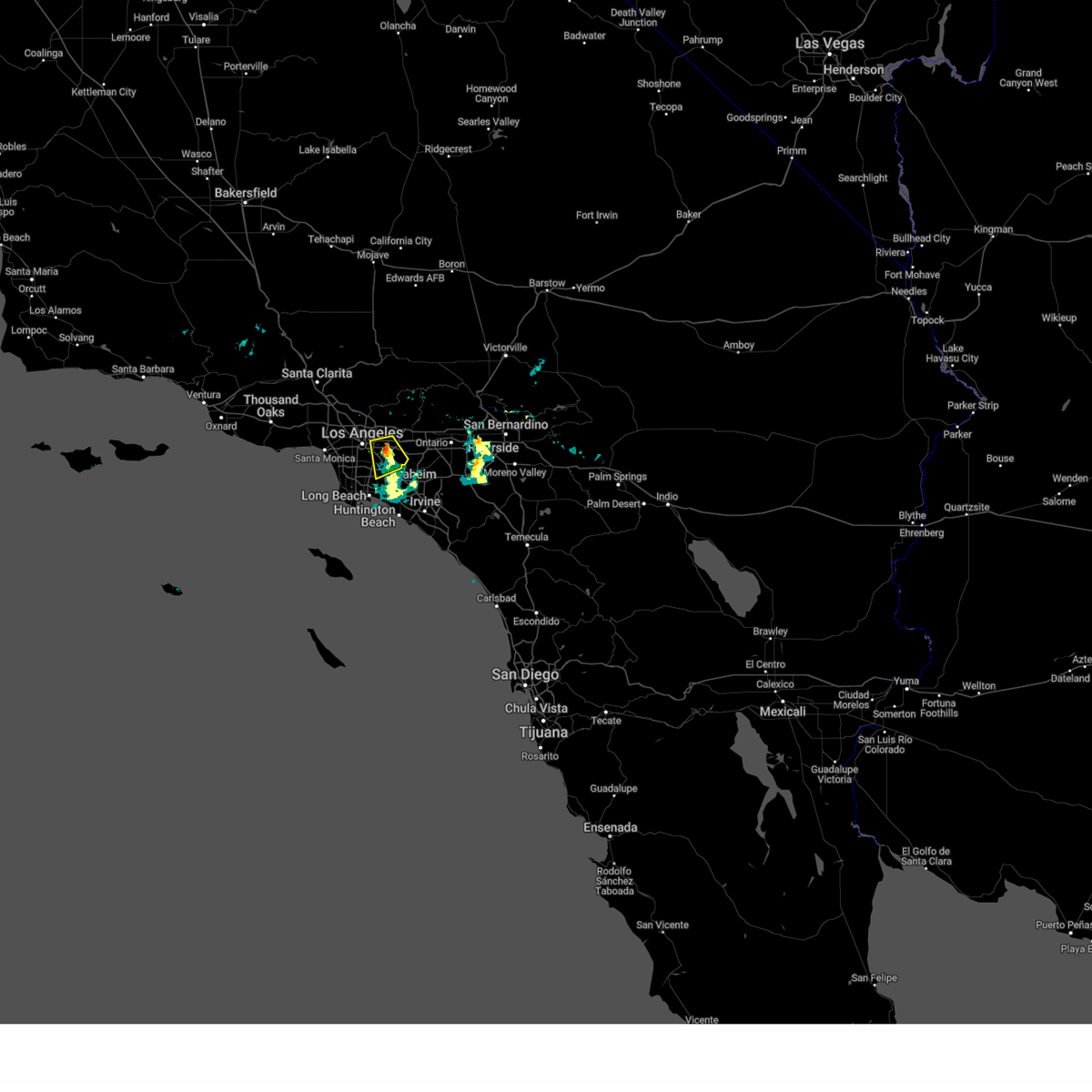
 the severe thunderstorm warning has been cancelled and is no longer in effect the severe thunderstorm warning has been cancelled and is no longer in effect
|
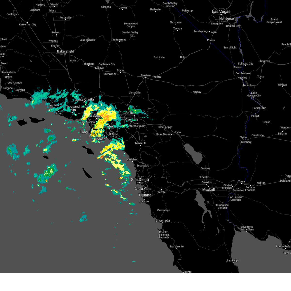
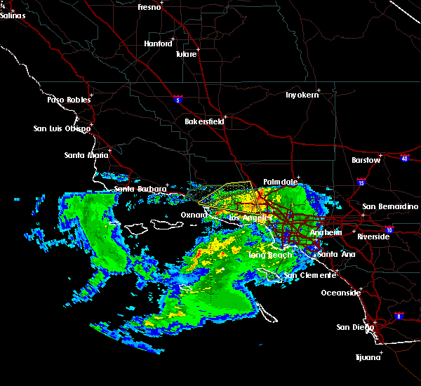
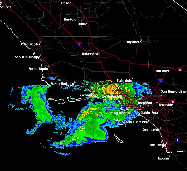
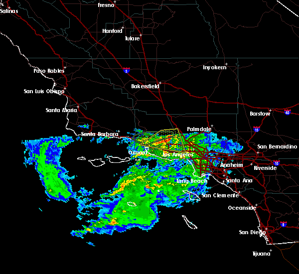
| 3/31/2024 12:32 AM PDT |
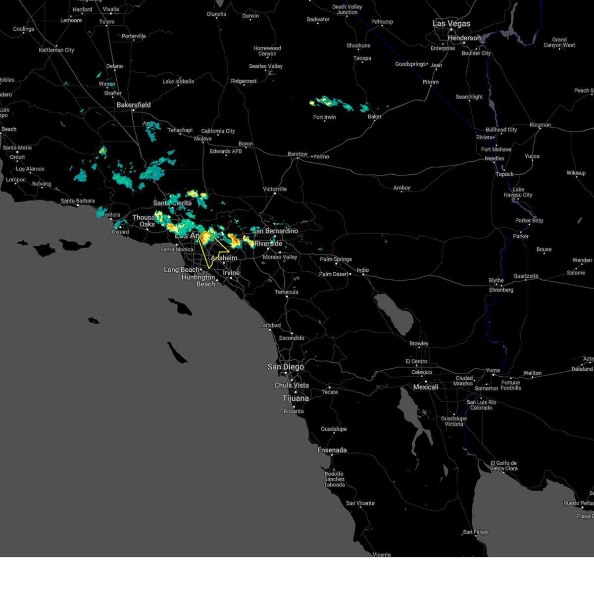
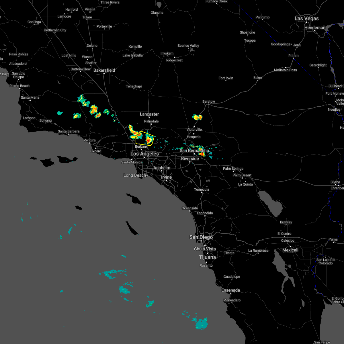
 Svrlox the national weather service in oxnard has issued a * severe thunderstorm warning for, southern los angeles county in southwestern california, * until 130 am pdt. * at 1228 am pdt, a severe thunderstorm was located just south of san pedro and long beach, moving north at 15 to 20 mph (radar indicated). Hazards include 60 mph wind gusts and penny size hail. expect damage to roofs, siding, and trees Svrlox the national weather service in oxnard has issued a * severe thunderstorm warning for, southern los angeles county in southwestern california, * until 130 am pdt. * at 1228 am pdt, a severe thunderstorm was located just south of san pedro and long beach, moving north at 15 to 20 mph (radar indicated). Hazards include 60 mph wind gusts and penny size hail. expect damage to roofs, siding, and trees
|
| 3/24/2024 4:25 PM PDT |
 the severe thunderstorm warning has been cancelled and is no longer in effect the severe thunderstorm warning has been cancelled and is no longer in effect
|
| 3/24/2024 4:10 PM PDT |
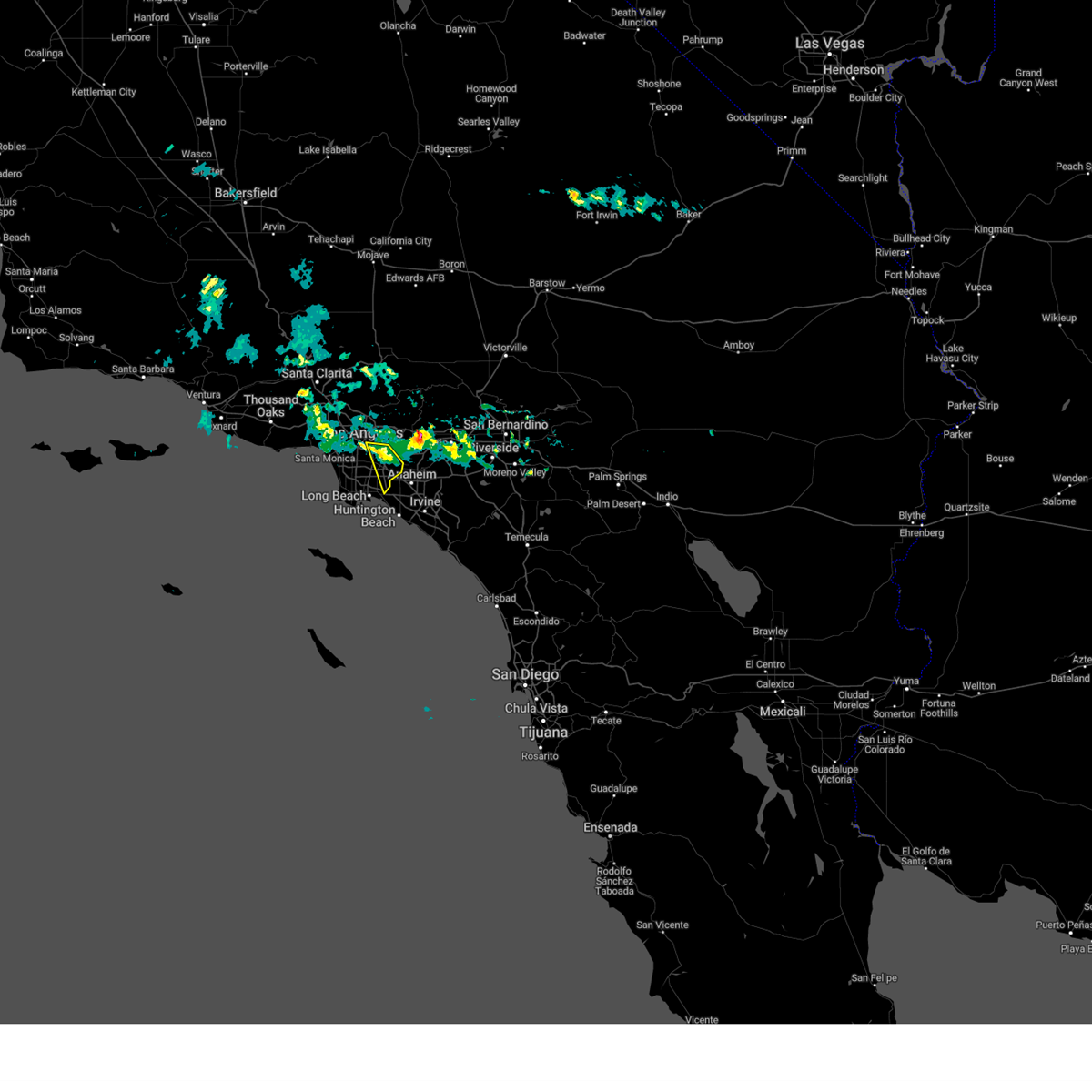 At 408 pm pdt, a severe thunderstorm was located near east los angeles extending southeast towards whittier, moving south at 15 mph (radar indicated). Hazards include 60 mph wind gusts and quarter size hail. Hail damage to vehicles is expected. expect wind damage to roofs, siding, and trees. Locations impacted include, whittier, la habra, cypress, los alamitos, artesia, commerce, montebello, boyle heights, santa fe springs, pico rivera, cerritos, monterey park, downey, norwalk, rossmoor, east los angeles, and bell gardens. At 408 pm pdt, a severe thunderstorm was located near east los angeles extending southeast towards whittier, moving south at 15 mph (radar indicated). Hazards include 60 mph wind gusts and quarter size hail. Hail damage to vehicles is expected. expect wind damage to roofs, siding, and trees. Locations impacted include, whittier, la habra, cypress, los alamitos, artesia, commerce, montebello, boyle heights, santa fe springs, pico rivera, cerritos, monterey park, downey, norwalk, rossmoor, east los angeles, and bell gardens.
|
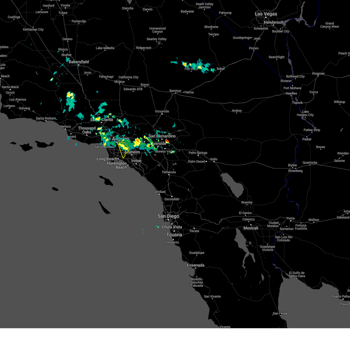
| 3/24/2024 3:42 PM PDT |
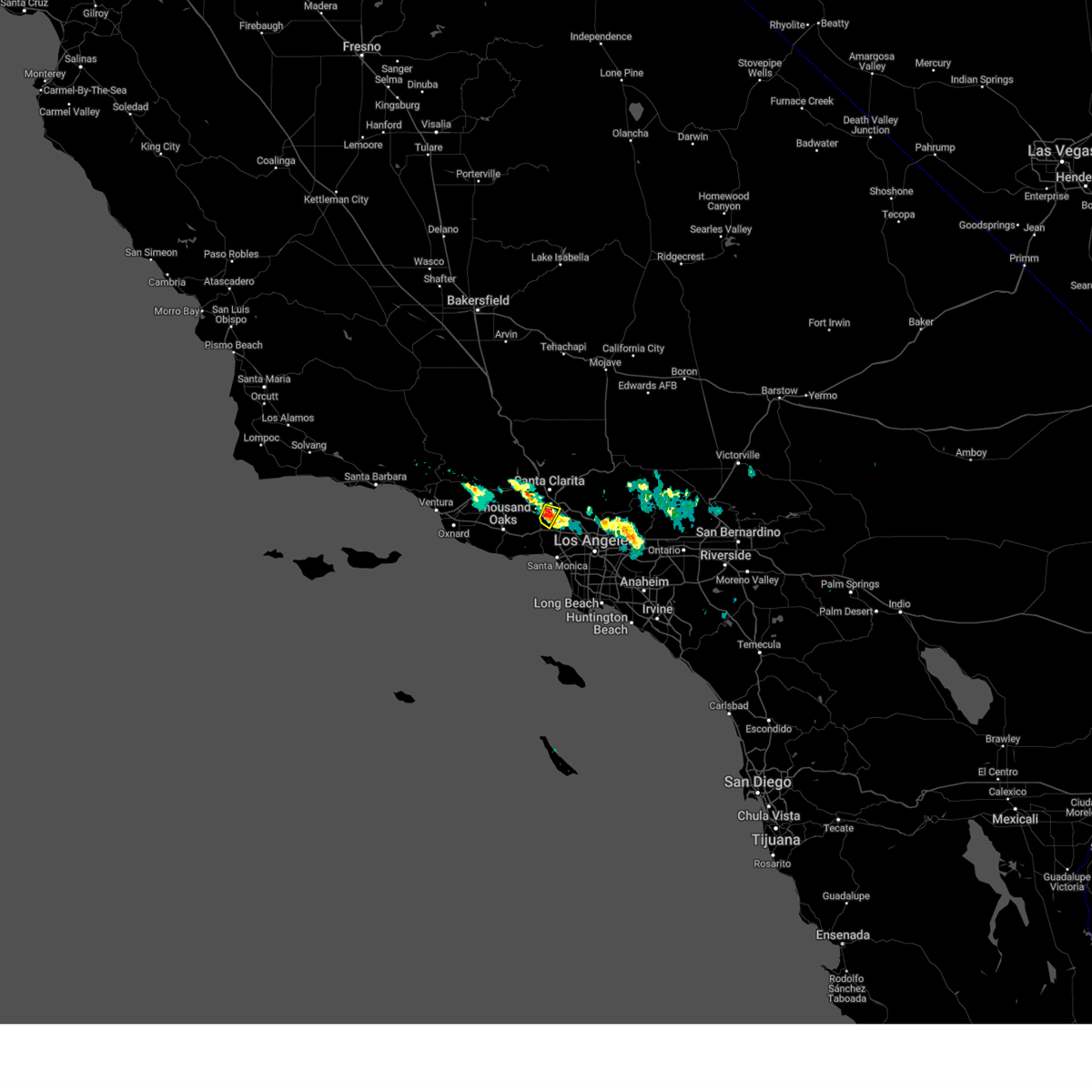
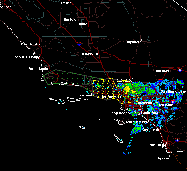
 Svrlox the national weather service in oxnard has issued a * severe thunderstorm warning for, east central los angeles county in southwestern california, * until 445 pm pdt. * at 340 pm pdt, a severe thunderstorm was located over alhambra, moving southeast at 15 mph (radar indicated). Hazards include 60 mph wind gusts and quarter size hail. Hail damage to vehicles is expected. expect wind damage to roofs, siding, and trees. Locations potentially impacted include, long beach, alhambra, whittier, pasadena, buena park, la habra, cypress, los alamitos, eagle rock, artesia, commerce, montebello, boyle heights, hacienda heights, santa fe springs, pico rivera, el monte, monterey park, and highland park. Svrlox the national weather service in oxnard has issued a * severe thunderstorm warning for, east central los angeles county in southwestern california, * until 445 pm pdt. * at 340 pm pdt, a severe thunderstorm was located over alhambra, moving southeast at 15 mph (radar indicated). Hazards include 60 mph wind gusts and quarter size hail. Hail damage to vehicles is expected. expect wind damage to roofs, siding, and trees. Locations potentially impacted include, long beach, alhambra, whittier, pasadena, buena park, la habra, cypress, los alamitos, eagle rock, artesia, commerce, montebello, boyle heights, hacienda heights, santa fe springs, pico rivera, el monte, monterey park, and highland park.
|
| 3/15/2024 6:07 PM PDT |
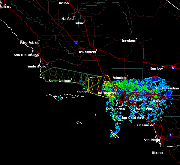
 Svrlox the national weather service in oxnard has issued a * severe thunderstorm warning for, east central los angeles county in southwestern california, * until 700 pm pdt. * at 603 pm pdt, a severe thunderstorm was located near west covina, moving south at around 10 mph (radar indicated). Hazards include 60 mph wind gusts and quarter size hail. Hail damage to vehicles is possible. potential for wind damage to roofs, siding, and trees. Locations potentially impacted include, whittier, alhambra, la habra, commerce, montebello, downey, hacienda heights, santa fe springs, norwalk, pico rivera, el monte, monterey park, san gabriel, cerritos, la habra heights, east los angeles, bell gardens, temple city, and paramount. Svrlox the national weather service in oxnard has issued a * severe thunderstorm warning for, east central los angeles county in southwestern california, * until 700 pm pdt. * at 603 pm pdt, a severe thunderstorm was located near west covina, moving south at around 10 mph (radar indicated). Hazards include 60 mph wind gusts and quarter size hail. Hail damage to vehicles is possible. potential for wind damage to roofs, siding, and trees. Locations potentially impacted include, whittier, alhambra, la habra, commerce, montebello, downey, hacienda heights, santa fe springs, norwalk, pico rivera, el monte, monterey park, san gabriel, cerritos, la habra heights, east los angeles, bell gardens, temple city, and paramount.
|
| 3/7/2024 4:19 PM PST |
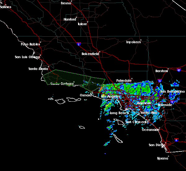
 The storm which prompted the warning has weakened below severe limits, and no longer poses an immediate threat to life or property. therefore, the warning has been allowed to expire. however, small hail and gusty winds are still possible with this thunderstorm. The storm which prompted the warning has weakened below severe limits, and no longer poses an immediate threat to life or property. therefore, the warning has been allowed to expire. however, small hail and gusty winds are still possible with this thunderstorm.
|
| 3/7/2024 3:44 PM PST |
 At 342 pm pst, a severe thunderstorm was located over northridge, moving southeast at 20 mph (radar indicated). Hazards include 60 mph wind gusts and quarter size hail. Hail damage to vehicles is expected. expect wind damage to roofs, siding, and trees. Locations impacted include, northridge, chatsworth, granada hills, porter ranch, canoga park, reseda, winnetka, and north hills. At 342 pm pst, a severe thunderstorm was located over northridge, moving southeast at 20 mph (radar indicated). Hazards include 60 mph wind gusts and quarter size hail. Hail damage to vehicles is expected. expect wind damage to roofs, siding, and trees. Locations impacted include, northridge, chatsworth, granada hills, porter ranch, canoga park, reseda, winnetka, and north hills.
|
| 3/7/2024 3:38 PM PST |
Quarter sized hail reported 22 miles SSE of Los Angeles, CA, quarter size hail.
|
| 3/7/2024 3:33 PM PST |
 Svrlox the national weather service in oxnard has issued a * severe thunderstorm warning for, western los angeles county in southwestern california, * until 415 pm pst. * at 332 pm pst, a severe thunderstorm was located over chatsworth, moving southeast at 25 mph (radar indicated). Hazards include 60 mph wind gusts and quarter size hail. Hail damage to vehicles is expected. Expect wind damage to roofs, siding, and trees. Svrlox the national weather service in oxnard has issued a * severe thunderstorm warning for, western los angeles county in southwestern california, * until 415 pm pst. * at 332 pm pst, a severe thunderstorm was located over chatsworth, moving southeast at 25 mph (radar indicated). Hazards include 60 mph wind gusts and quarter size hail. Hail damage to vehicles is expected. Expect wind damage to roofs, siding, and trees.
|
| 2/7/2024 8:36 PM PST |
 The severe thunderstorm warning for western los angeles county will expire at 845 pm pst, the storms which prompted the warning have weakened below severe limits, and no longer pose an immediate threat to life or property. therefore, the warning will be allowed to expire. however, gusty winds are still possible with these thunderstorms. The severe thunderstorm warning for western los angeles county will expire at 845 pm pst, the storms which prompted the warning have weakened below severe limits, and no longer pose an immediate threat to life or property. therefore, the warning will be allowed to expire. however, gusty winds are still possible with these thunderstorms.
|
| 2/7/2024 7:58 PM PST |
 At 754 pm pst, bands of showers producing 60 to 70 mph wind gusts were located along a line extending from porter ranch to 9 miles south of point dume, moving east at 45 mph (automated wind sensors). Hazards include 70 mph wind gusts. Expect considerable tree damage. damage is likely to mobile homes, roofs, and outbuildings. Locations impacted include, acton, north hollywood, encino, inglewood, woodland hills, malibu, agoura hills, venice, hollywood, van nuys, culver city, chatsworth, universal city, santa clarita, burbank, beverly hills, santa monica, northridge, griffith park, and pasadena. At 754 pm pst, bands of showers producing 60 to 70 mph wind gusts were located along a line extending from porter ranch to 9 miles south of point dume, moving east at 45 mph (automated wind sensors). Hazards include 70 mph wind gusts. Expect considerable tree damage. damage is likely to mobile homes, roofs, and outbuildings. Locations impacted include, acton, north hollywood, encino, inglewood, woodland hills, malibu, agoura hills, venice, hollywood, van nuys, culver city, chatsworth, universal city, santa clarita, burbank, beverly hills, santa monica, northridge, griffith park, and pasadena.
|
| 2/7/2024 7:41 PM PST |
 At 739 pm pst, bands of showers producing 60 to 70 mph wind gusts were located along a line extending from simi valley to 15 miles southwest of point dume, moving east at 45 mph (law enforcement reported trees down from this storm). Hazards include 70 mph wind gusts. Expect considerable tree damage. damage is likely to mobile homes, roofs, and outbuildings. Locations impacted include, thousand oaks, simi valley, camarillo, fillmore, acton, north hollywood, encino, inglewood, woodland hills, malibu, agoura hills, venice, hollywood, van nuys, culver city, chatsworth, universal city, santa clarita, burbank, and beverly hills. At 739 pm pst, bands of showers producing 60 to 70 mph wind gusts were located along a line extending from simi valley to 15 miles southwest of point dume, moving east at 45 mph (law enforcement reported trees down from this storm). Hazards include 70 mph wind gusts. Expect considerable tree damage. damage is likely to mobile homes, roofs, and outbuildings. Locations impacted include, thousand oaks, simi valley, camarillo, fillmore, acton, north hollywood, encino, inglewood, woodland hills, malibu, agoura hills, venice, hollywood, van nuys, culver city, chatsworth, universal city, santa clarita, burbank, and beverly hills.
|
| 2/7/2024 7:22 PM PST |
 At 721 pm pst, bands of showers producing 60 to 70 mph wind gusts were located along a line extending from near camarillo to 17 miles southeast of anacapa island, moving east at 45 mph (automated sensors). Hazards include 70 mph wind gusts. Expect considerable tree damage. Damage is likely to mobile homes, roofs, and outbuildings. At 721 pm pst, bands of showers producing 60 to 70 mph wind gusts were located along a line extending from near camarillo to 17 miles southeast of anacapa island, moving east at 45 mph (automated sensors). Hazards include 70 mph wind gusts. Expect considerable tree damage. Damage is likely to mobile homes, roofs, and outbuildings.
|
| 2/24/2023 9:51 PM PST |
 At 946 pm pst, a convective line of storms extended from near moorpark to near point mugu, moving east at 15 to 20 mph (radar indicated). Hazards include 60 mph wind gusts. expect damage to roofs, siding, and trees At 946 pm pst, a convective line of storms extended from near moorpark to near point mugu, moving east at 15 to 20 mph (radar indicated). Hazards include 60 mph wind gusts. expect damage to roofs, siding, and trees
|
| 9/4/2022 3:27 PM PDT |
 At 324 pm pdt, doppler radar indicated a severe thunderstorm capable of producing damaging winds in excess of 60 mph. this storm was located 7 miles northwest of mount wilson, and moving west at 10 mph. penny size hail may also accompany the damaging winds. At 324 pm pdt, doppler radar indicated a severe thunderstorm capable of producing damaging winds in excess of 60 mph. this storm was located 7 miles northwest of mount wilson, and moving west at 10 mph. penny size hail may also accompany the damaging winds.
|
| 9/4/2022 2:50 PM PDT |
 At 249 pm pdt, a severe thunderstorm was located near acton, moving west at 10 mph (radar indicated). Hazards include 60 mph wind gusts and quarter size hail. Hail damage to vehicles is expected. Expect wind damage to roofs, siding, and trees. At 249 pm pdt, a severe thunderstorm was located near acton, moving west at 10 mph (radar indicated). Hazards include 60 mph wind gusts and quarter size hail. Hail damage to vehicles is expected. Expect wind damage to roofs, siding, and trees.
|
| 10/4/2021 10:55 PM PDT |
Corrects previous downburst report from 5 nne san fernando. mesonet station cnic1 camp nine raws reported wind gusts to 57 mp in los angeles county CA, 24 miles S of Los Angeles, CA
|
| 10/4/2021 4:13 PM PDT |
Wind gusts to 58 mph at oat mountai in los angeles county CA, 25.3 miles SSE of Los Angeles, CA
|
| 3/7/2016 7:15 AM PST |
 At 715 am pst, doppler radar continued to indicate a line of severe thunderstorms capable of producing damaging winds. winds gusts up to 60 mph have been observed with this line of thunderstorms. these storms were located along a line extending from near littlerock to placentia, moving northeast at 45 mph. locations impacted include, chino, lake los angeles, wrightwood, whittier, san dimas, glendora, west covina, pomona, and chino hills. At 715 am pst, doppler radar continued to indicate a line of severe thunderstorms capable of producing damaging winds. winds gusts up to 60 mph have been observed with this line of thunderstorms. these storms were located along a line extending from near littlerock to placentia, moving northeast at 45 mph. locations impacted include, chino, lake los angeles, wrightwood, whittier, san dimas, glendora, west covina, pomona, and chino hills.
|
| 3/7/2016 6:53 AM PST |
 At 653 am pst, doppler radar indicated a line of severe thunderstorms capable of producing damaging winds in excess of 60 mph. these storms were located along a line extending from near acton to westminster, moving northeast at 45 mph. locations impacted include, long beach, chino, seal beach, lake los angeles, acton, wrightwood, whittier, griffith park, pasadena, downtown los angeles, san dimas, glendora, alhambra, west covina, burbank, pomona, mount wilson, hollywood, buena park, and chino hills. At 653 am pst, doppler radar indicated a line of severe thunderstorms capable of producing damaging winds in excess of 60 mph. these storms were located along a line extending from near acton to westminster, moving northeast at 45 mph. locations impacted include, long beach, chino, seal beach, lake los angeles, acton, wrightwood, whittier, griffith park, pasadena, downtown los angeles, san dimas, glendora, alhambra, west covina, burbank, pomona, mount wilson, hollywood, buena park, and chino hills.
|
| 3/7/2016 6:46 AM PST |
 At 646 am pst, doppler radar indicated a line of severe thunderstorms capable of producing damaging winds in excess of 60 mph. these storms were located along a line extending from near acton to near seal beach, and moving northeast at 45 mph. At 646 am pst, doppler radar indicated a line of severe thunderstorms capable of producing damaging winds in excess of 60 mph. these storms were located along a line extending from near acton to near seal beach, and moving northeast at 45 mph.
|
| 3/7/2016 6:25 AM PST |
 The severe thunderstorm warning for northwestern los angeles, northern ventura and southeastern santa barbara counties will expire at 630 am pst, the severe thunderstorm which prompted the warning has weakened and moved out of the warned area. therefore the warning will be allowed to expire. however, gusty winds up to 45 mph are still possible with line of thunderstorms. The severe thunderstorm warning for northwestern los angeles, northern ventura and southeastern santa barbara counties will expire at 630 am pst, the severe thunderstorm which prompted the warning has weakened and moved out of the warned area. therefore the warning will be allowed to expire. however, gusty winds up to 45 mph are still possible with line of thunderstorms.
|
| 3/7/2016 6:24 AM PST |
Mesonet station port of la angels gate /agxc1/ in los angeles county CA, 20.6 miles NNW of Los Angeles, CA
|
| 3/7/2016 6:12 AM PST |
Large tree down on ucla campus. flooding in schoenberg hal in los angeles county CA, 6.8 miles SE of Los Angeles, CA
|
|
|
| 3/7/2016 6:00 AM PST |
Power outage reported at los angeles international airport causing flight delays and ground sto in los angeles county CA, 5.8 miles NE of Los Angeles, CA
|
| 3/7/2016 5:52 AM PST |
 At 546 am pst, doppler radar indicated a severe thunderstorm capable of producing destructive winds in excess of 70 mph. point mugu reported a wind of 64 mph. this leading edge of the severe thunderstorm was located around filmore to the north extending south across zuma beach. expect strong wind gusts over 60 mph to continue with this strong squall line. this storm will continue to move east at 45 mph. locations impacted include, oxnard, thousand oaks, simi valley, malibu, woodland hills, santa monica, and beverly hills. At 546 am pst, doppler radar indicated a severe thunderstorm capable of producing destructive winds in excess of 70 mph. point mugu reported a wind of 64 mph. this leading edge of the severe thunderstorm was located around filmore to the north extending south across zuma beach. expect strong wind gusts over 60 mph to continue with this strong squall line. this storm will continue to move east at 45 mph. locations impacted include, oxnard, thousand oaks, simi valley, malibu, woodland hills, santa monica, and beverly hills.
|
| 3/7/2016 5:25 AM PST |
 At 523 am pst, doppler radar indicated a severe thunderstorm capable of producing destructive winds in excess of 70 mph. this storm was located over western ventura county and will move east into western los angeles county. this line of thunderstorms was moving east at 45 mph. At 523 am pst, doppler radar indicated a severe thunderstorm capable of producing destructive winds in excess of 70 mph. this storm was located over western ventura county and will move east into western los angeles county. this line of thunderstorms was moving east at 45 mph.
|
| 1/31/2016 1:50 PM PST |
 At 148 pm pst, doppler radar indicated a severe thunderstorm capable of producing damaging winds in excess of 60 mph. this storm was located 7 miles northeast of mount wilson, and moving northeast at 45 mph. At 148 pm pst, doppler radar indicated a severe thunderstorm capable of producing damaging winds in excess of 60 mph. this storm was located 7 miles northeast of mount wilson, and moving northeast at 45 mph.
|
| 1/31/2016 1:37 PM PST |
Roof blown off house and hit power lines on 600 block of s ditman avenu in los angeles county CA, 9.3 miles W of Los Angeles, CA
|
| 1/31/2016 1:31 PM PST |
Downed power line hit vehicl in los angeles county CA, 16.1 miles SE of Los Angeles, CA
|
| 1/31/2016 1:24 PM PST |
Tree fell on vehicle on highway 13 in los angeles county CA, 10.2 miles SSW of Los Angeles, CA
|
| 1/31/2016 1:24 PM PST |
 At 119 pm pst, there were reports of trees down across portions of ventura and santa paula. doppler radar indicated the bulk of the storm has moved in the santa clarita valley. the severe thunderstorm will be allowed to expire at 130 pm, but more thunderstorms will be possible through this afternoon. locations impacted include, oxnard, thousand oaks, simi valley, eastern ventura, camarillo, fillmore, malibu, chatsworth woodland hills, agoura hills, northridge, encino, van nuys, santa clarita, santa paula, canoga park, westlake village, calabasas, and newbury park. At 119 pm pst, there were reports of trees down across portions of ventura and santa paula. doppler radar indicated the bulk of the storm has moved in the santa clarita valley. the severe thunderstorm will be allowed to expire at 130 pm, but more thunderstorms will be possible through this afternoon. locations impacted include, oxnard, thousand oaks, simi valley, eastern ventura, camarillo, fillmore, malibu, chatsworth woodland hills, agoura hills, northridge, encino, van nuys, santa clarita, santa paula, canoga park, westlake village, calabasas, and newbury park.
|
| 1/31/2016 1:08 PM PST |
 At 105 pm pst, doppler radar indicated a severe thunderstorm capable of producing damaging winds in excess of 60 mph. this storm was located near malibu in west los angeles to burbank. there will be the possibility of a small brief tornado with this squall line. At 105 pm pst, doppler radar indicated a severe thunderstorm capable of producing damaging winds in excess of 60 mph. this storm was located near malibu in west los angeles to burbank. there will be the possibility of a small brief tornado with this squall line.
|
| 1/31/2016 12:54 PM PST |
 At 1249 pm pst, doppler radar indicated a strong squall line moving northeast at 45 mph through filmore to near malibu capable of producing damaging winds in excess of 60 mph. a few trees were knocked down around santa paula with this line of storms. locations impacted include, thousand oaks, simi valley, chatsworth, woodland hills, agoura hills, northridge, encino, santa clarita, santa paula, canoga park, westlake village, calabasas, and newbury park. At 1249 pm pst, doppler radar indicated a strong squall line moving northeast at 45 mph through filmore to near malibu capable of producing damaging winds in excess of 60 mph. a few trees were knocked down around santa paula with this line of storms. locations impacted include, thousand oaks, simi valley, chatsworth, woodland hills, agoura hills, northridge, encino, santa clarita, santa paula, canoga park, westlake village, calabasas, and newbury park.
|
| 1/31/2016 12:34 PM PST |
 At 1228 pm pst, doppler radar indicated a strong squall line capable of producing damaging winds in excess of 60 mph. this storm was located near santa paula to the north and oxnard to the south. this storm will continue to move east-northeast towards eastern ventura county and western los angeles county. the squall line was moving east at 40 mph. brief weak tornadic spin ups are possible with this squall. At 1228 pm pst, doppler radar indicated a strong squall line capable of producing damaging winds in excess of 60 mph. this storm was located near santa paula to the north and oxnard to the south. this storm will continue to move east-northeast towards eastern ventura county and western los angeles county. the squall line was moving east at 40 mph. brief weak tornadic spin ups are possible with this squall.
|
| 1/6/2016 10:55 AM PST |
 The severe thunderstorm warning for northwestern los angeles and northeastern ventura counties will expire at 1100 am pst, the storm which prompted the warning has weakened below severe limits. therefore the warning will be allowed to expire. however heavy rain and occasional lightning is still possible with this thunderstorm in the vicinity of the ventura and los angeles county border from val verde to woodland hills. The severe thunderstorm warning for northwestern los angeles and northeastern ventura counties will expire at 1100 am pst, the storm which prompted the warning has weakened below severe limits. therefore the warning will be allowed to expire. however heavy rain and occasional lightning is still possible with this thunderstorm in the vicinity of the ventura and los angeles county border from val verde to woodland hills.
|
| 1/6/2016 10:45 AM PST |
 At 1044 am pst, doppler radar indicated a severe thunderstorm capable of producing damaging winds in excess of 60 mph. this storm was located near simi valley, moving east at 35 mph. penny size hail may also accompany the damaging winds. locations impacted include, thousand oaks, simi valley, chatsworth, woodland hills, calabasas, moorpark, lake piru, somis, piru, and winnetka. At 1044 am pst, doppler radar indicated a severe thunderstorm capable of producing damaging winds in excess of 60 mph. this storm was located near simi valley, moving east at 35 mph. penny size hail may also accompany the damaging winds. locations impacted include, thousand oaks, simi valley, chatsworth, woodland hills, calabasas, moorpark, lake piru, somis, piru, and winnetka.
|
| 1/6/2016 10:31 AM PST |
 At 1028 am pst, doppler radar indicated a severe thunderstorm capable of producing damaging winds in excess of 60 mph. this storm was located near fillmore, and moving east at 35 mph. penny size hail may also accompany the damaging winds. At 1028 am pst, doppler radar indicated a severe thunderstorm capable of producing damaging winds in excess of 60 mph. this storm was located near fillmore, and moving east at 35 mph. penny size hail may also accompany the damaging winds.
|


Connect with Interactive Hail Maps