

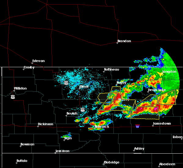
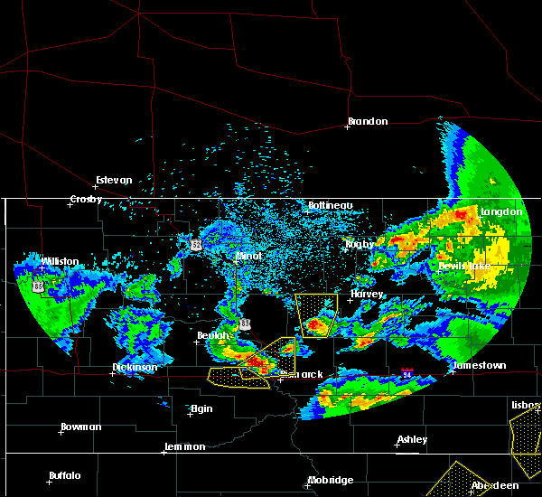
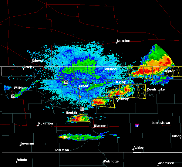
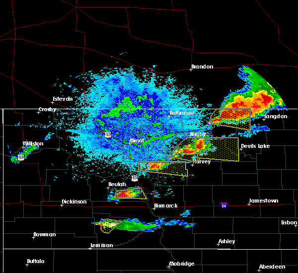
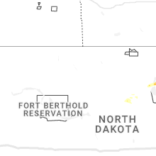
Hail Map for Martin, ND
The Martin, ND area has had 1 report of on-the-ground hail by trained spotters, and has been under severe weather warnings 0 times during the past 12 months. Doppler radar has detected hail at or near Martin, ND on 31 occasions, including 3 occasions during the past year.
| Name: | Martin, ND |
| Where Located: | 61.6 miles ESE of Minot, ND |
| Map: | Google Map for Martin, ND |
| Population: | 78 |
| Housing Units: | 43 |
| More Info: | Search Google for Martin, ND |
0
The Top Recent Hail Date for Martin, ND is Monday, July 31, 2023 (31st out of 31)

Hail and Wind Damage Spotted near Martin, ND
| Date / Time | Report Details |
|---|---|
| 6/13/2022 10:22 PM CDT |
 At 1022 pm cdt, severe thunderstorms were located along a line extending from 6 miles north of maddock to 8 miles west of fessenden to 10 miles north of wing, moving east at 40 mph (radar indicated). Hazards include 70 mph wind gusts and half dollar size hail. Hail damage to vehicles is expected. expect considerable tree damage. wind damage is also likely to mobile homes, roofs, and outbuildings. locations impacted include, harvey, mcclusky, fessenden, goodrich, hurdsfield, martin, bowdon, heimdal, bremen, manfred, chaseley, denhoff, hamberg, sheyenne lake, selz, wellsburg, hoffer lake and emrick. thunderstorm damage threat, considerable hail threat, radar indicated max hail size, 1. 25 in wind threat, radar indicated max wind gust, 70 mph. At 1022 pm cdt, severe thunderstorms were located along a line extending from 6 miles north of maddock to 8 miles west of fessenden to 10 miles north of wing, moving east at 40 mph (radar indicated). Hazards include 70 mph wind gusts and half dollar size hail. Hail damage to vehicles is expected. expect considerable tree damage. wind damage is also likely to mobile homes, roofs, and outbuildings. locations impacted include, harvey, mcclusky, fessenden, goodrich, hurdsfield, martin, bowdon, heimdal, bremen, manfred, chaseley, denhoff, hamberg, sheyenne lake, selz, wellsburg, hoffer lake and emrick. thunderstorm damage threat, considerable hail threat, radar indicated max hail size, 1. 25 in wind threat, radar indicated max wind gust, 70 mph.
|
| 6/13/2022 10:20 PM CDT | Quarter sized hail reported 4 miles NW of Martin, ND, pictures submitted via facebook showing estimated quarter sized hail. reporter also estimated 60 mph wind gusts and 1.30 inches of rain. |
| 6/13/2022 10:02 PM CDT |
 At 1002 pm cdt, severe thunderstorms were located along a line extending from near esmond to 9 miles north of goodrich to 5 miles north of regan, moving east at 40 mph (radar indicated). Hazards include golf ball size hail and 70 mph wind gusts. People and animals outdoors will be injured. expect hail damage to roofs, siding, windows, and vehicles. expect considerable tree damage. wind damage is also likely to mobile homes, roofs, and outbuildings. locations impacted include, harvey, mcclusky, fessenden, anamoose, goodrich, hurdsfield, martin, bowdon, heimdal, bremen, manfred, chaseley, denhoff, hamberg, sheyenne lake, selz, wellsburg, hoffer lake and emrick. thunderstorm damage threat, considerable hail threat, radar indicated max hail size, 1. 75 in wind threat, radar indicated max wind gust, 70 mph. At 1002 pm cdt, severe thunderstorms were located along a line extending from near esmond to 9 miles north of goodrich to 5 miles north of regan, moving east at 40 mph (radar indicated). Hazards include golf ball size hail and 70 mph wind gusts. People and animals outdoors will be injured. expect hail damage to roofs, siding, windows, and vehicles. expect considerable tree damage. wind damage is also likely to mobile homes, roofs, and outbuildings. locations impacted include, harvey, mcclusky, fessenden, anamoose, goodrich, hurdsfield, martin, bowdon, heimdal, bremen, manfred, chaseley, denhoff, hamberg, sheyenne lake, selz, wellsburg, hoffer lake and emrick. thunderstorm damage threat, considerable hail threat, radar indicated max hail size, 1. 75 in wind threat, radar indicated max wind gust, 70 mph.
|
| 6/13/2022 9:54 PM CDT |
 At 954 pm cdt, severe thunderstorms were located along a line extending from 5 miles southwest of esmond to 7 miles north of goodrich to 6 miles northwest of regan, moving east at 40 mph (radar indicated). Hazards include 70 mph wind gusts and half dollar size hail. Hail damage to vehicles is expected. expect considerable tree damage. Wind damage is also likely to mobile homes, roofs, and outbuildings. At 954 pm cdt, severe thunderstorms were located along a line extending from 5 miles southwest of esmond to 7 miles north of goodrich to 6 miles northwest of regan, moving east at 40 mph (radar indicated). Hazards include 70 mph wind gusts and half dollar size hail. Hail damage to vehicles is expected. expect considerable tree damage. Wind damage is also likely to mobile homes, roofs, and outbuildings.
|
| 6/13/2022 9:53 PM CDT |
 At 953 pm cdt, a severe thunderstorm capable of producing a tornado was located over martin, or 7 miles west of harvey, moving northeast at 40 mph (radar indicated rotation). Hazards include tornado and half dollar size hail. Flying debris will be dangerous to those caught without shelter. mobile homes will be damaged or destroyed. damage to roofs, windows, and vehicles will occur. tree damage is likely. this dangerous storm will be near, harvey around 1000 pm cdt. Other locations impacted by this tornadic thunderstorm include heimdal, wellsburg and selz. At 953 pm cdt, a severe thunderstorm capable of producing a tornado was located over martin, or 7 miles west of harvey, moving northeast at 40 mph (radar indicated rotation). Hazards include tornado and half dollar size hail. Flying debris will be dangerous to those caught without shelter. mobile homes will be damaged or destroyed. damage to roofs, windows, and vehicles will occur. tree damage is likely. this dangerous storm will be near, harvey around 1000 pm cdt. Other locations impacted by this tornadic thunderstorm include heimdal, wellsburg and selz.
|
| 6/13/2022 9:38 PM CDT |
 At 937 pm cdt, severe thunderstorms were located along a line extending from near rugby to 6 miles north of balta to 13 miles west of esmond to 8 miles northeast of anamoose to 6 miles southwest of martin, moving east at 30 mph (radar indicated). Hazards include 60 mph wind gusts and penny size hail. Expect damage to roofs, siding, and trees. locations impacted include, rugby, anamoose, martin, balta, berwick, sheyenne lake, krueger lake, silva and orrin. hail threat, radar indicated max hail size, 0. 75 in wind threat, radar indicated max wind gust, 60 mph. At 937 pm cdt, severe thunderstorms were located along a line extending from near rugby to 6 miles north of balta to 13 miles west of esmond to 8 miles northeast of anamoose to 6 miles southwest of martin, moving east at 30 mph (radar indicated). Hazards include 60 mph wind gusts and penny size hail. Expect damage to roofs, siding, and trees. locations impacted include, rugby, anamoose, martin, balta, berwick, sheyenne lake, krueger lake, silva and orrin. hail threat, radar indicated max hail size, 0. 75 in wind threat, radar indicated max wind gust, 60 mph.
|
| 6/13/2022 9:16 PM CDT |
 At 915 pm cdt, severe thunderstorms were located along a line extending from 5 miles southeast of towner to 9 miles west of balta to 9 miles north of anamoose to near drake to 12 miles southeast of butte, moving east at 40 mph (radar indicated). Hazards include 60 mph wind gusts. Expect damage to roofs, siding, and trees. locations impacted include, balta, rugby and martin. hail threat, radar indicated max hail size, <. 75 in wind threat, radar indicated max wind gust, 60 mph. At 915 pm cdt, severe thunderstorms were located along a line extending from 5 miles southeast of towner to 9 miles west of balta to 9 miles north of anamoose to near drake to 12 miles southeast of butte, moving east at 40 mph (radar indicated). Hazards include 60 mph wind gusts. Expect damage to roofs, siding, and trees. locations impacted include, balta, rugby and martin. hail threat, radar indicated max hail size, <. 75 in wind threat, radar indicated max wind gust, 60 mph.
|
| 6/13/2022 8:54 PM CDT |
 At 853 pm cdt, severe thunderstorms were located along a line extending from 4 miles south of denbigh to 6 miles northeast of karlsruhe to 10 miles west of drake to near butte to 12 miles northeast of turtle lake, moving east at 30 mph (radar indicated). Hazards include 60 mph wind gusts. Expect damage to roofs, siding, and trees. severe thunderstorms will be near, denbigh around 900 pm cdt. other locations in the path of these severe thunderstorms include towner, drake, anamoose, balta, rugby and martin. hail threat, radar indicated max hail size, <. 75 in wind threat, radar indicated max wind gust, 60 mph. At 853 pm cdt, severe thunderstorms were located along a line extending from 4 miles south of denbigh to 6 miles northeast of karlsruhe to 10 miles west of drake to near butte to 12 miles northeast of turtle lake, moving east at 30 mph (radar indicated). Hazards include 60 mph wind gusts. Expect damage to roofs, siding, and trees. severe thunderstorms will be near, denbigh around 900 pm cdt. other locations in the path of these severe thunderstorms include towner, drake, anamoose, balta, rugby and martin. hail threat, radar indicated max hail size, <. 75 in wind threat, radar indicated max wind gust, 60 mph.
|
| 6/6/2021 1:52 AM CDT |
 At 152 am cdt, severe thunderstorms were located along a line extending from 5 miles northwest of wolford to 10 miles south of esmond to 9 miles south of hurdsfield, moving east at 60 mph (surface observations). Hazards include 60 mph wind gusts and quarter size hail. Hail damage to vehicles is expected. Expect wind damage to roofs, siding, and trees. At 152 am cdt, severe thunderstorms were located along a line extending from 5 miles northwest of wolford to 10 miles south of esmond to 9 miles south of hurdsfield, moving east at 60 mph (surface observations). Hazards include 60 mph wind gusts and quarter size hail. Hail damage to vehicles is expected. Expect wind damage to roofs, siding, and trees.
|
| 7/17/2020 6:43 PM CDT |
 At 643 pm cdt, severe thunderstorms were located along a line extending from 5 miles northeast of esmond to 7 miles east of harvey to 4 miles southwest of goodrich, moving east at 30 mph (radar indicated). Hazards include 60 mph wind gusts and quarter size hail. Hail damage to vehicles is expected. expect wind damage to roofs, siding, and trees. these severe storms will be near, fessenden around 700 pm cdt. Other locations impacted by these severe thunderstorms include sheyenne lake, manfred, emrick, denhoff, bremen, heaton, selz, hamberg, bowdon and heimdal. At 643 pm cdt, severe thunderstorms were located along a line extending from 5 miles northeast of esmond to 7 miles east of harvey to 4 miles southwest of goodrich, moving east at 30 mph (radar indicated). Hazards include 60 mph wind gusts and quarter size hail. Hail damage to vehicles is expected. expect wind damage to roofs, siding, and trees. these severe storms will be near, fessenden around 700 pm cdt. Other locations impacted by these severe thunderstorms include sheyenne lake, manfred, emrick, denhoff, bremen, heaton, selz, hamberg, bowdon and heimdal.
|
| 7/17/2020 6:29 PM CDT |
 At 628 pm cdt, severe thunderstorms were located along a line extending from 9 miles west of esmond to 5 miles southwest of martin, moving east at 15 mph (radar indicated). Hazards include golf ball size hail and 60 mph wind gusts. People and animals outdoors will be injured. expect hail damage to roofs, siding, windows, and vehicles. expect wind damage to roofs, siding, and trees. These severe thunderstorms will remain over mainly rural areas of northeastern sheridan and southwestern pierce counties, including the following locations, orrin. At 628 pm cdt, severe thunderstorms were located along a line extending from 9 miles west of esmond to 5 miles southwest of martin, moving east at 15 mph (radar indicated). Hazards include golf ball size hail and 60 mph wind gusts. People and animals outdoors will be injured. expect hail damage to roofs, siding, windows, and vehicles. expect wind damage to roofs, siding, and trees. These severe thunderstorms will remain over mainly rural areas of northeastern sheridan and southwestern pierce counties, including the following locations, orrin.
|
| 7/17/2020 6:28 PM CDT |
 At 627 pm cdt, severe thunderstorms were located along a line extending from 5 miles northwest of esmond to harvey to 4 miles southeast of mcclusky, moving east at 15 mph (radar indicated). Hazards include golf ball size hail and 60 mph wind gusts. People and animals outdoors will be injured. expect hail damage to roofs, siding, windows, and vehicles. expect wind damage to roofs, siding, and trees. Locations impacted include, harvey, mcclusky, fessenden, anamoose, goodrich, martin, cathay, bowdon, heimdal, bremen, manfred, denhoff, hamberg, sheyenne lake, selz, wellsburg, hoffer lake, emrick, heaton and orrin. At 627 pm cdt, severe thunderstorms were located along a line extending from 5 miles northwest of esmond to harvey to 4 miles southeast of mcclusky, moving east at 15 mph (radar indicated). Hazards include golf ball size hail and 60 mph wind gusts. People and animals outdoors will be injured. expect hail damage to roofs, siding, windows, and vehicles. expect wind damage to roofs, siding, and trees. Locations impacted include, harvey, mcclusky, fessenden, anamoose, goodrich, martin, cathay, bowdon, heimdal, bremen, manfred, denhoff, hamberg, sheyenne lake, selz, wellsburg, hoffer lake, emrick, heaton and orrin.
|
| 7/17/2020 6:07 PM CDT |
 At 607 pm cdt, severe thunderstorms were located along a line extending from 7 miles north of drake to 6 miles east of butte, moving east at 30 mph (radar indicated). Hazards include golf ball size hail and 60 mph wind gusts. People and animals outdoors will be injured. expect hail damage to roofs, siding, windows, and vehicles. expect wind damage to roofs, siding, and trees. these severe storms will be near, drake around 610 pm cdt. anamoose around 635 pm cdt. martin around 650 pm cdt. Other locations impacted by these severe thunderstorms include balfour, orrin, krueger lake and kief. At 607 pm cdt, severe thunderstorms were located along a line extending from 7 miles north of drake to 6 miles east of butte, moving east at 30 mph (radar indicated). Hazards include golf ball size hail and 60 mph wind gusts. People and animals outdoors will be injured. expect hail damage to roofs, siding, windows, and vehicles. expect wind damage to roofs, siding, and trees. these severe storms will be near, drake around 610 pm cdt. anamoose around 635 pm cdt. martin around 650 pm cdt. Other locations impacted by these severe thunderstorms include balfour, orrin, krueger lake and kief.
|
| 7/17/2020 6:01 PM CDT |
 The national weather service in bismarck has issued a * severe thunderstorm warning for. wells county in south central north dakota. central sheridan county in south central north dakota. southwestern pierce county in north central north dakota. Southeastern mchenry county in north central north dakota. The national weather service in bismarck has issued a * severe thunderstorm warning for. wells county in south central north dakota. central sheridan county in south central north dakota. southwestern pierce county in north central north dakota. Southeastern mchenry county in north central north dakota.
|
| 7/17/2020 5:44 PM CDT |
 At 543 pm cdt, severe thunderstorms were located along a line extending from 5 miles south of karlsruhe to 9 miles west of butte, moving east at 25 mph (radar indicated). Hazards include golf ball size hail and 60 mph wind gusts. People and animals outdoors will be injured. expect hail damage to roofs, siding, windows, and vehicles. expect wind damage to roofs, siding, and trees. severe thunderstorms will be near, butte around 610 pm cdt. drake around 615 pm cdt. anamoose around 645 pm cdt. Other locations impacted by these severe thunderstorms include balfour, orrin, krueger lake, kief and bergen. At 543 pm cdt, severe thunderstorms were located along a line extending from 5 miles south of karlsruhe to 9 miles west of butte, moving east at 25 mph (radar indicated). Hazards include golf ball size hail and 60 mph wind gusts. People and animals outdoors will be injured. expect hail damage to roofs, siding, windows, and vehicles. expect wind damage to roofs, siding, and trees. severe thunderstorms will be near, butte around 610 pm cdt. drake around 615 pm cdt. anamoose around 645 pm cdt. Other locations impacted by these severe thunderstorms include balfour, orrin, krueger lake, kief and bergen.
|
| 7/8/2020 12:22 AM CDT |
 At 1221 am cdt, severe thunderstorms were located along a line extending from near butte to 12 miles north of goodrich to 6 miles northeast of tuttle to 7 miles northwest of braddock, moving northeast at 65 mph. these are very dangerous storms (radar indicated). Hazards include 80 mph wind gusts and quarter size hail. Flying debris will be dangerous to those caught without shelter. mobile homes will be heavily damaged. expect considerable damage to roofs, windows, and vehicles. extensive tree damage and power outages are likely. these severe storms will be near, harvey and steele around 1235 am cdt. lake isabel around 1240 am cdt. dawson around 1245 am cdt. tappen around 1250 am cdt. Other locations impacted by these severe thunderstorms include sheyenne lake, manfred, driscoll, krueger lake, strawberry lake, mckenzie, new johns lake, bowdon, wellsburg and arena. At 1221 am cdt, severe thunderstorms were located along a line extending from near butte to 12 miles north of goodrich to 6 miles northeast of tuttle to 7 miles northwest of braddock, moving northeast at 65 mph. these are very dangerous storms (radar indicated). Hazards include 80 mph wind gusts and quarter size hail. Flying debris will be dangerous to those caught without shelter. mobile homes will be heavily damaged. expect considerable damage to roofs, windows, and vehicles. extensive tree damage and power outages are likely. these severe storms will be near, harvey and steele around 1235 am cdt. lake isabel around 1240 am cdt. dawson around 1245 am cdt. tappen around 1250 am cdt. Other locations impacted by these severe thunderstorms include sheyenne lake, manfred, driscoll, krueger lake, strawberry lake, mckenzie, new johns lake, bowdon, wellsburg and arena.
|
| 7/8/2020 12:06 AM CDT |
 At 1206 am cdt, severe thunderstorms were located along a line extending from 5 miles east of benedict to near mcclusky to wing to 11 miles south of menoken, moving northeast at 60 mph. these are very dangerous storms (radar indicated). Hazards include 80 mph wind gusts and quarter size hail. Flying debris will be dangerous to those caught without shelter. mobile homes will be heavily damaged. expect considerable damage to roofs, windows, and vehicles. extensive tree damage and power outages are likely. these severe storms will be near, mcclusky and wing around 1210 am cdt. sterling, tuttle and butte around 1220 am cdt. steele around 1235 am cdt. harvey and lake isabel around 1240 am cdt. dawson around 1245 am cdt. tappen around 1250 am cdt. Other locations impacted by these severe thunderstorms include sheyenne lake, manfred, driscoll, krueger lake, strawberry lake, mckenzie, new johns lake, bowdon, wellsburg and arena. At 1206 am cdt, severe thunderstorms were located along a line extending from 5 miles east of benedict to near mcclusky to wing to 11 miles south of menoken, moving northeast at 60 mph. these are very dangerous storms (radar indicated). Hazards include 80 mph wind gusts and quarter size hail. Flying debris will be dangerous to those caught without shelter. mobile homes will be heavily damaged. expect considerable damage to roofs, windows, and vehicles. extensive tree damage and power outages are likely. these severe storms will be near, mcclusky and wing around 1210 am cdt. sterling, tuttle and butte around 1220 am cdt. steele around 1235 am cdt. harvey and lake isabel around 1240 am cdt. dawson around 1245 am cdt. tappen around 1250 am cdt. Other locations impacted by these severe thunderstorms include sheyenne lake, manfred, driscoll, krueger lake, strawberry lake, mckenzie, new johns lake, bowdon, wellsburg and arena.
|
| 7/7/2020 11:53 PM CDT |
 At 1153 pm cdt, severe thunderstorms were located along a line extending from near benedict to near mercer to 5 miles south of regan to 7 miles south of lincoln, moving northeast at 60 mph (radar indicated). Hazards include 70 mph wind gusts and half dollar size hail. Hail damage to vehicles is expected. expect considerable tree damage. wind damage is also likely to mobile homes, roofs, and outbuildings. severe thunderstorms will be near, mcclusky and wing around 1205 am cdt. sterling and butte around 1215 am cdt. tuttle around 1220 am cdt. steele around 1230 am cdt. harvey around 1235 am cdt. dawson and lake isabel around 1240 am cdt. fessenden and tappen around 1245 am cdt. pettibone around 1255 am cdt. Other locations impacted by these severe thunderstorms include sheyenne lake, manfred, driscoll, krueger lake, strawberry lake, mckenzie, new johns lake, bowdon, wellsburg and arena. At 1153 pm cdt, severe thunderstorms were located along a line extending from near benedict to near mercer to 5 miles south of regan to 7 miles south of lincoln, moving northeast at 60 mph (radar indicated). Hazards include 70 mph wind gusts and half dollar size hail. Hail damage to vehicles is expected. expect considerable tree damage. wind damage is also likely to mobile homes, roofs, and outbuildings. severe thunderstorms will be near, mcclusky and wing around 1205 am cdt. sterling and butte around 1215 am cdt. tuttle around 1220 am cdt. steele around 1230 am cdt. harvey around 1235 am cdt. dawson and lake isabel around 1240 am cdt. fessenden and tappen around 1245 am cdt. pettibone around 1255 am cdt. Other locations impacted by these severe thunderstorms include sheyenne lake, manfred, driscoll, krueger lake, strawberry lake, mckenzie, new johns lake, bowdon, wellsburg and arena.
|
| 6/30/2020 2:57 PM CDT |
 A severe thunderstorm warning remains in effect until 330 pm cdt for northwestern wells. northeastern sheridan and southwestern pierce counties. at 256 pm cdt, severe thunderstorms were located along a line extending from near martin to near fessenden, moving north at 20 mph. hazard. 60 mph wind gusts and quarter size hail. A severe thunderstorm warning remains in effect until 330 pm cdt for northwestern wells. northeastern sheridan and southwestern pierce counties. at 256 pm cdt, severe thunderstorms were located along a line extending from near martin to near fessenden, moving north at 20 mph. hazard. 60 mph wind gusts and quarter size hail.
|
| 6/30/2020 2:38 PM CDT |
 At 237 pm cdt, severe thunderstorms were located along a line extending from 6 miles southwest of martin to 5 miles southeast of harvey to 9 miles northeast of hurdsfield, moving north at 40 mph (radar indicated). Hazards include 60 mph wind gusts and quarter size hail. Hail damage to vehicles is expected. expect wind damage to roofs, siding, and trees. severe thunderstorms will be near, martin around 245 pm cdt. harvey and anamoose around 250 pm cdt. drake around 300 pm cdt. Other locations impacted by these severe thunderstorms include sheyenne lake, manfred, heimdal, wellsburg and selz. At 237 pm cdt, severe thunderstorms were located along a line extending from 6 miles southwest of martin to 5 miles southeast of harvey to 9 miles northeast of hurdsfield, moving north at 40 mph (radar indicated). Hazards include 60 mph wind gusts and quarter size hail. Hail damage to vehicles is expected. expect wind damage to roofs, siding, and trees. severe thunderstorms will be near, martin around 245 pm cdt. harvey and anamoose around 250 pm cdt. drake around 300 pm cdt. Other locations impacted by these severe thunderstorms include sheyenne lake, manfred, heimdal, wellsburg and selz.
|
| 6/7/2020 10:13 PM CDT |
 At 1013 pm cdt, a severe thunderstorm was located 5 miles northeast of mcclusky, moving north at 30 mph (radar indicated). Hazards include 60 mph wind gusts and quarter size hail. Hail damage to vehicles is expected. expect wind damage to roofs, siding, and trees. This severe thunderstorm will remain over mainly rural areas of sheridan county, including the following locations, sheyenne lake, hoffer lake, krueger lake and kief. At 1013 pm cdt, a severe thunderstorm was located 5 miles northeast of mcclusky, moving north at 30 mph (radar indicated). Hazards include 60 mph wind gusts and quarter size hail. Hail damage to vehicles is expected. expect wind damage to roofs, siding, and trees. This severe thunderstorm will remain over mainly rural areas of sheridan county, including the following locations, sheyenne lake, hoffer lake, krueger lake and kief.
|
| 6/7/2020 9:57 PM CDT |
 At 957 pm cdt, a severe thunderstorm was located 5 miles southeast of mcclusky, moving north at 30 mph (radar indicated). Hazards include 60 mph wind gusts and quarter size hail. Hail damage to vehicles is expected. expect wind damage to roofs, siding, and trees. this severe thunderstorm will be near, mcclusky around 1005 pm cdt. Other locations impacted by this severe thunderstorm include sheyenne lake, hoffer lake, krueger lake, denhoff and kief. At 957 pm cdt, a severe thunderstorm was located 5 miles southeast of mcclusky, moving north at 30 mph (radar indicated). Hazards include 60 mph wind gusts and quarter size hail. Hail damage to vehicles is expected. expect wind damage to roofs, siding, and trees. this severe thunderstorm will be near, mcclusky around 1005 pm cdt. Other locations impacted by this severe thunderstorm include sheyenne lake, hoffer lake, krueger lake, denhoff and kief.
|
| 9/2/2019 3:02 PM CDT |
 At 301 pm cdt, a severe thunderstorm was located 8 miles north of goodrich, or 14 miles southwest of harvey, moving east at 45 mph (radar indicated). Hazards include 70 mph wind gusts and quarter size hail. Hail damage to vehicles is expected. expect considerable tree damage. wind damage is also likely to mobile homes, roofs, and outbuildings. this severe thunderstorm will be near, hurdsfield around 320 pm cdt. Other locations impacted by this severe thunderstorm include sheyenne lake, manfred, bowdon, wellsburg, sykeston, hoffer lake, chaseley, emrick, denhoff and bremen. At 301 pm cdt, a severe thunderstorm was located 8 miles north of goodrich, or 14 miles southwest of harvey, moving east at 45 mph (radar indicated). Hazards include 70 mph wind gusts and quarter size hail. Hail damage to vehicles is expected. expect considerable tree damage. wind damage is also likely to mobile homes, roofs, and outbuildings. this severe thunderstorm will be near, hurdsfield around 320 pm cdt. Other locations impacted by this severe thunderstorm include sheyenne lake, manfred, bowdon, wellsburg, sykeston, hoffer lake, chaseley, emrick, denhoff and bremen.
|
| 8/25/2019 4:51 PM CDT |
 At 451 pm cdt, a severe thunderstorm was located over harvey, moving northeast at 40 mph (radar indicated). Hazards include 60 mph wind gusts and half dollar size hail. Hail damage to vehicles is expected. expect wind damage to roofs, siding, and trees. this severe storm will be near, harvey around 455 pm cdt. Other locations impacted by this severe thunderstorm include sheyenne lake, hoffer lake, manfred, denhoff and selz. At 451 pm cdt, a severe thunderstorm was located over harvey, moving northeast at 40 mph (radar indicated). Hazards include 60 mph wind gusts and half dollar size hail. Hail damage to vehicles is expected. expect wind damage to roofs, siding, and trees. this severe storm will be near, harvey around 455 pm cdt. Other locations impacted by this severe thunderstorm include sheyenne lake, hoffer lake, manfred, denhoff and selz.
|
| 8/25/2019 4:28 PM CDT |
 At 427 pm cdt, a severe thunderstorm was located 12 miles northeast of mcclusky, moving northeast at 40 mph (radar indicated). Hazards include golf ball size hail and 60 mph wind gusts. People and animals outdoors will be injured. expect hail damage to roofs, siding, windows, and vehicles. expect wind damage to roofs, siding, and trees. this severe thunderstorm will be near, martin around 450 pm cdt. harvey around 455 pm cdt. Other locations impacted by this severe thunderstorm include sheyenne lake, hoffer lake, manfred, denhoff and selz. At 427 pm cdt, a severe thunderstorm was located 12 miles northeast of mcclusky, moving northeast at 40 mph (radar indicated). Hazards include golf ball size hail and 60 mph wind gusts. People and animals outdoors will be injured. expect hail damage to roofs, siding, windows, and vehicles. expect wind damage to roofs, siding, and trees. this severe thunderstorm will be near, martin around 450 pm cdt. harvey around 455 pm cdt. Other locations impacted by this severe thunderstorm include sheyenne lake, hoffer lake, manfred, denhoff and selz.
|
| 8/25/2019 4:09 PM CDT |
 At 409 pm cdt, a severe thunderstorm was located 10 miles southwest of martin, or 16 miles west of harvey, moving northeast at 25 mph (public). Hazards include golf ball size hail and 60 mph wind gusts. People and animals outdoors will be injured. expect hail damage to roofs, siding, windows, and vehicles. expect wind damage to roofs, siding, and trees. this severe storm will be near, anamoose and martin around 430 pm cdt. Other locations impacted by this severe thunderstorm include sheyenne lake. At 409 pm cdt, a severe thunderstorm was located 10 miles southwest of martin, or 16 miles west of harvey, moving northeast at 25 mph (public). Hazards include golf ball size hail and 60 mph wind gusts. People and animals outdoors will be injured. expect hail damage to roofs, siding, windows, and vehicles. expect wind damage to roofs, siding, and trees. this severe storm will be near, anamoose and martin around 430 pm cdt. Other locations impacted by this severe thunderstorm include sheyenne lake.
|
| 8/25/2019 3:59 PM CDT |
 At 358 pm cdt, a severe thunderstorm was located 14 miles north of mcclusky, moving northeast at 25 mph (radar indicated). Hazards include 60 mph wind gusts and half dollar size hail. Hail damage to vehicles is expected. expect wind damage to roofs, siding, and trees. this severe thunderstorm will be near, anamoose and martin around 430 pm cdt. Other locations impacted by this severe thunderstorm include sheyenne lake. At 358 pm cdt, a severe thunderstorm was located 14 miles north of mcclusky, moving northeast at 25 mph (radar indicated). Hazards include 60 mph wind gusts and half dollar size hail. Hail damage to vehicles is expected. expect wind damage to roofs, siding, and trees. this severe thunderstorm will be near, anamoose and martin around 430 pm cdt. Other locations impacted by this severe thunderstorm include sheyenne lake.
|
| 8/5/2019 12:34 AM CDT |
 At 1234 am cdt, a severe thunderstorm was located near harvey, moving southeast at 35 mph (radar indicated). Hazards include 70 mph wind gusts and quarter size hail. Hail damage to vehicles is expected. expect considerable tree damage. wind damage is also likely to mobile homes, roofs, and outbuildings. This severe thunderstorm will remain over mainly rural areas of northwestern wells, northeastern sheridan and southwestern pierce counties, including the following locations, manfred, heimdal, wellsburg and selz. At 1234 am cdt, a severe thunderstorm was located near harvey, moving southeast at 35 mph (radar indicated). Hazards include 70 mph wind gusts and quarter size hail. Hail damage to vehicles is expected. expect considerable tree damage. wind damage is also likely to mobile homes, roofs, and outbuildings. This severe thunderstorm will remain over mainly rural areas of northwestern wells, northeastern sheridan and southwestern pierce counties, including the following locations, manfred, heimdal, wellsburg and selz.
|
| 8/5/2019 12:22 AM CDT |
 At 1222 am cdt, a severe thunderstorm was located over martin, or 10 miles northwest of harvey, moving southeast at 35 mph (radar indicated). Hazards include 60 mph wind gusts and penny size hail. Expect damage to roofs, siding, and trees. this severe thunderstorm will be near, harvey around 1240 am cdt. Other locations impacted by this severe thunderstorm include manfred, heimdal, wellsburg and selz. At 1222 am cdt, a severe thunderstorm was located over martin, or 10 miles northwest of harvey, moving southeast at 35 mph (radar indicated). Hazards include 60 mph wind gusts and penny size hail. Expect damage to roofs, siding, and trees. this severe thunderstorm will be near, harvey around 1240 am cdt. Other locations impacted by this severe thunderstorm include manfred, heimdal, wellsburg and selz.
|
| 7/14/2018 7:02 PM CDT |
 At 702 pm cdt, a severe thunderstorm was located near harvey, moving east at 35 mph (radar indicated). Hazards include quarter size hail. Damage to vehicles is expected. this severe storm will be near, harvey around 705 pm cdt. Other locations impacted by this severe thunderstorm include selz. At 702 pm cdt, a severe thunderstorm was located near harvey, moving east at 35 mph (radar indicated). Hazards include quarter size hail. Damage to vehicles is expected. this severe storm will be near, harvey around 705 pm cdt. Other locations impacted by this severe thunderstorm include selz.
|
| 7/14/2018 6:53 PM CDT |
 At 653 pm cdt, a severe thunderstorm was located near martin, or 9 miles northwest of harvey, moving east at 35 mph (radar indicated). Hazards include quarter size hail. Damage to vehicles is expected. this severe storm will be near, harvey around 705 pm cdt. Other locations impacted by this severe thunderstorm include selz. At 653 pm cdt, a severe thunderstorm was located near martin, or 9 miles northwest of harvey, moving east at 35 mph (radar indicated). Hazards include quarter size hail. Damage to vehicles is expected. this severe storm will be near, harvey around 705 pm cdt. Other locations impacted by this severe thunderstorm include selz.
|
| 7/14/2018 6:38 PM CDT |
 At 636 pm cdt, a severe thunderstorm was located over anamoose, or 17 miles northwest of harvey, moving east at 35 mph (radar indicated). Hazards include half dollar size hail. Damage to vehicles is expected. this severe storm will be near, martin around 650 pm cdt. harvey around 705 pm cdt. Other locations impacted by this severe thunderstorm include selz. At 636 pm cdt, a severe thunderstorm was located over anamoose, or 17 miles northwest of harvey, moving east at 35 mph (radar indicated). Hazards include half dollar size hail. Damage to vehicles is expected. this severe storm will be near, martin around 650 pm cdt. harvey around 705 pm cdt. Other locations impacted by this severe thunderstorm include selz.
|
| 7/14/2018 6:22 PM CDT |
 At 622 pm cdt, a severe thunderstorm was located near drake, or 25 miles west of harvey, moving east at 35 mph (radar indicated). Hazards include half dollar size hail. Damage to vehicles is expected. this severe thunderstorm will be near, drake around 630 pm cdt. anamoose around 640 pm cdt. martin around 650 pm cdt. harvey around 705 pm cdt. Other locations impacted by this severe thunderstorm include kief, balfour and selz. At 622 pm cdt, a severe thunderstorm was located near drake, or 25 miles west of harvey, moving east at 35 mph (radar indicated). Hazards include half dollar size hail. Damage to vehicles is expected. this severe thunderstorm will be near, drake around 630 pm cdt. anamoose around 640 pm cdt. martin around 650 pm cdt. harvey around 705 pm cdt. Other locations impacted by this severe thunderstorm include kief, balfour and selz.
|
| 6/29/2018 1:57 AM CDT |
 At 125 am cdt, severe thunderstorms were located along a line extending from near anamoose to 4 miles west of hurdsfield to 9 miles south of wing, moving east at 55 mph (radar indicated). Hazards include 70 mph wind gusts and nickel size hail. Expect considerable tree damage. damage is likely to mobile homes, roofs, and outbuildings. severe thunderstorms will be near, hurdsfield around 130 am cdt. harvey around 140 am cdt. carrington around 210 am cdt. bordulac around 220 am cdt. Other locations impacted by these severe thunderstorms include sheyenne lake, manfred, krueger lake, chase lake, bowdon, wellsburg, barlow, arena, sykeston and hoffer lake. At 125 am cdt, severe thunderstorms were located along a line extending from near anamoose to 4 miles west of hurdsfield to 9 miles south of wing, moving east at 55 mph (radar indicated). Hazards include 70 mph wind gusts and nickel size hail. Expect considerable tree damage. damage is likely to mobile homes, roofs, and outbuildings. severe thunderstorms will be near, hurdsfield around 130 am cdt. harvey around 140 am cdt. carrington around 210 am cdt. bordulac around 220 am cdt. Other locations impacted by these severe thunderstorms include sheyenne lake, manfred, krueger lake, chase lake, bowdon, wellsburg, barlow, arena, sykeston and hoffer lake.
|
| 6/29/2018 1:36 AM CDT |
 The severe thunderstorm warning for sheridan, eastern mclean, northern burleigh and eastern oliver counties will expire at 145 am cdt, the storms which prompted the warning have moved out of the area. therefore, the warning will be allowed to expire. however gusty winds and heavy rain are still possible with these thunderstorms. a severe thunderstorm watch remains in effect until 800 am cdt for south central and north central north dakota. The severe thunderstorm warning for sheridan, eastern mclean, northern burleigh and eastern oliver counties will expire at 145 am cdt, the storms which prompted the warning have moved out of the area. therefore, the warning will be allowed to expire. however gusty winds and heavy rain are still possible with these thunderstorms. a severe thunderstorm watch remains in effect until 800 am cdt for south central and north central north dakota.
|
| 6/29/2018 1:25 AM CDT |
 At 125 am cdt, severe thunderstorms were located along a line extending from near anamoose to 4 miles west of hurdsfield to 9 miles south of wing, moving east at 55 mph (radar indicated). Hazards include 70 mph wind gusts and nickel size hail. Expect considerable tree damage. damage is likely to mobile homes, roofs, and outbuildings. severe thunderstorms will be near, hurdsfield around 130 am cdt. harvey around 140 am cdt. carrington around 210 am cdt. bordulac around 220 am cdt. Other locations impacted by these severe thunderstorms include sheyenne lake, manfred, krueger lake, chase lake, bowdon, wellsburg, barlow, arena, sykeston and hoffer lake. At 125 am cdt, severe thunderstorms were located along a line extending from near anamoose to 4 miles west of hurdsfield to 9 miles south of wing, moving east at 55 mph (radar indicated). Hazards include 70 mph wind gusts and nickel size hail. Expect considerable tree damage. damage is likely to mobile homes, roofs, and outbuildings. severe thunderstorms will be near, hurdsfield around 130 am cdt. harvey around 140 am cdt. carrington around 210 am cdt. bordulac around 220 am cdt. Other locations impacted by these severe thunderstorms include sheyenne lake, manfred, krueger lake, chase lake, bowdon, wellsburg, barlow, arena, sykeston and hoffer lake.
|
| 6/29/2018 1:14 AM CDT |
 At 114 am cdt, severe thunderstorms were located along a line extending from 6 miles southwest of anamoose to 6 miles southwest of mcclusky to 10 miles north of mcdowell dam recreation area, moving east at 45 mph (radar indicated). Hazards include 60 mph wind gusts and quarter size hail. Hail damage to vehicles is expected. expect wind damage to roofs, siding, and trees. these severe storms will be near, martin around 130 am cdt. goodrich around 140 am cdt. Other locations impacted by these severe thunderstorms include sheyenne lake, hoffer lake, krueger lake, denhoff, price, new johns lake, baldwin, sanger, arena and kief. At 114 am cdt, severe thunderstorms were located along a line extending from 6 miles southwest of anamoose to 6 miles southwest of mcclusky to 10 miles north of mcdowell dam recreation area, moving east at 45 mph (radar indicated). Hazards include 60 mph wind gusts and quarter size hail. Hail damage to vehicles is expected. expect wind damage to roofs, siding, and trees. these severe storms will be near, martin around 130 am cdt. goodrich around 140 am cdt. Other locations impacted by these severe thunderstorms include sheyenne lake, hoffer lake, krueger lake, denhoff, price, new johns lake, baldwin, sanger, arena and kief.
|
| 6/29/2018 12:39 AM CDT |
 At 1238 am cdt, severe thunderstorms were located along a line extending from 8 miles west of butte to 4 miles southeast of underwood to 10 miles southeast of center, moving east at 40 mph. these are very dangerous storms (radar indicated). Hazards include 80 mph wind gusts and half dollar size hail. Flying debris will be dangerous to those caught without shelter. mobile homes will be heavily damaged. expect considerable damage to roofs, windows, and vehicles. extensive tree damage and power outages are likely. severe thunderstorms will be near, turtle lake and butte around 1250 am cdt. mercer around 100 am cdt. mcclusky around 120 am cdt. martin around 125 am cdt. goodrich around 140 am cdt. Other locations impacted by these severe thunderstorms include sheyenne lake, krueger lake, strawberry lake, new johns lake, baldwin, hensler, fort clark, arena, nelson lake and hoffer lake. At 1238 am cdt, severe thunderstorms were located along a line extending from 8 miles west of butte to 4 miles southeast of underwood to 10 miles southeast of center, moving east at 40 mph. these are very dangerous storms (radar indicated). Hazards include 80 mph wind gusts and half dollar size hail. Flying debris will be dangerous to those caught without shelter. mobile homes will be heavily damaged. expect considerable damage to roofs, windows, and vehicles. extensive tree damage and power outages are likely. severe thunderstorms will be near, turtle lake and butte around 1250 am cdt. mercer around 100 am cdt. mcclusky around 120 am cdt. martin around 125 am cdt. goodrich around 140 am cdt. Other locations impacted by these severe thunderstorms include sheyenne lake, krueger lake, strawberry lake, new johns lake, baldwin, hensler, fort clark, arena, nelson lake and hoffer lake.
|
| 6/28/2018 8:38 PM CDT |
 At 838 pm cdt, a severe thunderstorm was located near harvey, moving east at 20 mph (radar indicated). Hazards include ping pong ball size hail and 60 mph wind gusts. People and animals outdoors will be injured. expect hail damage to roofs, siding, windows, and vehicles. expect wind damage to roofs, siding, and trees. this severe storm will be near, harvey around 850 pm cdt. other locations impacted by this severe thunderstorm include hamberg, heimdal, wellsburg and selz. A tornado watch remains in effect until 1100 pm cdt for south central and north central north dakota. At 838 pm cdt, a severe thunderstorm was located near harvey, moving east at 20 mph (radar indicated). Hazards include ping pong ball size hail and 60 mph wind gusts. People and animals outdoors will be injured. expect hail damage to roofs, siding, windows, and vehicles. expect wind damage to roofs, siding, and trees. this severe storm will be near, harvey around 850 pm cdt. other locations impacted by this severe thunderstorm include hamberg, heimdal, wellsburg and selz. A tornado watch remains in effect until 1100 pm cdt for south central and north central north dakota.
|
| 6/28/2018 8:24 PM CDT |
 At 824 pm cdt, a severe thunderstorm was located near martin, or near harvey, moving northeast at 30 mph (radar indicated). Hazards include 60 mph wind gusts and quarter size hail. Hail damage to vehicles is expected. expect wind damage to roofs, siding, and trees. this severe thunderstorm will be near, harvey around 830 pm cdt. other locations impacted by this severe thunderstorm include hamberg, heimdal, wellsburg and selz. A tornado watch remains in effect until 1100 pm cdt for south central and north central north dakota. At 824 pm cdt, a severe thunderstorm was located near martin, or near harvey, moving northeast at 30 mph (radar indicated). Hazards include 60 mph wind gusts and quarter size hail. Hail damage to vehicles is expected. expect wind damage to roofs, siding, and trees. this severe thunderstorm will be near, harvey around 830 pm cdt. other locations impacted by this severe thunderstorm include hamberg, heimdal, wellsburg and selz. A tornado watch remains in effect until 1100 pm cdt for south central and north central north dakota.
|
| 6/28/2018 7:40 PM CDT |
 At 740 pm cdt, a severe thunderstorm was located over martin, or 10 miles northwest of harvey, moving northeast at 25 mph (radar indicated). Hazards include 60 mph wind gusts and quarter size hail. Hail damage to vehicles is expected. expect wind damage to roofs, siding, and trees. this severe thunderstorm will remain over mainly rural areas of northwestern wells, northeastern sheridan, southwestern pierce and southeastern mchenry counties, including the following locations, selz. A tornado watch remains in effect until 1100 pm cdt for south central and north central north dakota. At 740 pm cdt, a severe thunderstorm was located over martin, or 10 miles northwest of harvey, moving northeast at 25 mph (radar indicated). Hazards include 60 mph wind gusts and quarter size hail. Hail damage to vehicles is expected. expect wind damage to roofs, siding, and trees. this severe thunderstorm will remain over mainly rural areas of northwestern wells, northeastern sheridan, southwestern pierce and southeastern mchenry counties, including the following locations, selz. A tornado watch remains in effect until 1100 pm cdt for south central and north central north dakota.
|
| 6/28/2018 7:18 PM CDT |
 At 718 pm cdt, a severe thunderstorm was located 9 miles southwest of martin, or 15 miles west of harvey, moving northeast at 15 mph (radar indicated). Hazards include ping pong ball size hail and 60 mph wind gusts. People and animals outdoors will be injured. expect hail damage to roofs, siding, windows, and vehicles. expect wind damage to roofs, siding, and trees. this severe storm will be near, anamoose around 755 pm cdt. martin around 800 pm cdt. other locations impacted by this severe thunderstorm include sheyenne lake, krueger lake and selz. A tornado watch remains in effect until 1100 pm cdt for south central and north central north dakota. At 718 pm cdt, a severe thunderstorm was located 9 miles southwest of martin, or 15 miles west of harvey, moving northeast at 15 mph (radar indicated). Hazards include ping pong ball size hail and 60 mph wind gusts. People and animals outdoors will be injured. expect hail damage to roofs, siding, windows, and vehicles. expect wind damage to roofs, siding, and trees. this severe storm will be near, anamoose around 755 pm cdt. martin around 800 pm cdt. other locations impacted by this severe thunderstorm include sheyenne lake, krueger lake and selz. A tornado watch remains in effect until 1100 pm cdt for south central and north central north dakota.
|
| 6/28/2018 7:09 PM CDT |
 At 709 pm cdt, a severe thunderstorm was located 9 miles southwest of martin, or 15 miles west of harvey, moving northeast at 25 mph (radar indicated). Hazards include 60 mph wind gusts and quarter size hail. Hail damage to vehicles is expected. expect wind damage to roofs, siding, and trees. this severe thunderstorm will be near, anamoose around 730 pm cdt. martin around 735 pm cdt. harvey around 745 pm cdt. other locations impacted by this severe thunderstorm include sheyenne lake, krueger lake and selz. A tornado watch remains in effect until 1100 pm cdt for south central and north central north dakota. At 709 pm cdt, a severe thunderstorm was located 9 miles southwest of martin, or 15 miles west of harvey, moving northeast at 25 mph (radar indicated). Hazards include 60 mph wind gusts and quarter size hail. Hail damage to vehicles is expected. expect wind damage to roofs, siding, and trees. this severe thunderstorm will be near, anamoose around 730 pm cdt. martin around 735 pm cdt. harvey around 745 pm cdt. other locations impacted by this severe thunderstorm include sheyenne lake, krueger lake and selz. A tornado watch remains in effect until 1100 pm cdt for south central and north central north dakota.
|
| 7/21/2017 1:50 PM CDT |
 At 149 pm cdt, a severe thunderstorm was located 9 miles southwest of harvey, moving east at 40 mph (radar indicated). Hazards include 60 mph wind gusts and quarter size hail. Hail damage to vehicles is expected. expect wind damage to roofs, siding, and trees. this severe thunderstorm will be near, fessenden around 220 pm cdt. Other locations impacted by this severe thunderstorm include sheyenne lake, manfred, chaseley, emrick, denhoff, bremen, heaton, hamberg, heimdal and bowdon. At 149 pm cdt, a severe thunderstorm was located 9 miles southwest of harvey, moving east at 40 mph (radar indicated). Hazards include 60 mph wind gusts and quarter size hail. Hail damage to vehicles is expected. expect wind damage to roofs, siding, and trees. this severe thunderstorm will be near, fessenden around 220 pm cdt. Other locations impacted by this severe thunderstorm include sheyenne lake, manfred, chaseley, emrick, denhoff, bremen, heaton, hamberg, heimdal and bowdon.
|
| 7/14/2017 5:25 PM CDT |
 At 525 pm cdt, a severe thunderstorm was located 5 miles northeast of butte, or 27 miles north of mcclusky, moving east at 40 mph (radar indicated). Hazards include 60 mph wind gusts and quarter size hail. Hail damage to vehicles is expected. expect wind damage to roofs, siding, and trees. Locations impacted include, drake, anamoose, martin, butte, balfour, kief, sheyenne lake and krueger lake. At 525 pm cdt, a severe thunderstorm was located 5 miles northeast of butte, or 27 miles north of mcclusky, moving east at 40 mph (radar indicated). Hazards include 60 mph wind gusts and quarter size hail. Hail damage to vehicles is expected. expect wind damage to roofs, siding, and trees. Locations impacted include, drake, anamoose, martin, butte, balfour, kief, sheyenne lake and krueger lake.
|
| 7/14/2017 5:04 PM CDT |
 The national weather service in bismarck has issued a * severe thunderstorm warning for. southeastern ward county in north central north dakota. northern sheridan county in south central north dakota. northeastern mclean county in south central north dakota. Southern mchenry county in north central north dakota. The national weather service in bismarck has issued a * severe thunderstorm warning for. southeastern ward county in north central north dakota. northern sheridan county in south central north dakota. northeastern mclean county in south central north dakota. Southern mchenry county in north central north dakota.
|
| 6/9/2017 5:40 PM CDT |
 At 540 pm cdt, a severe thunderstorm was located 10 miles northeast of anamoose, or 16 miles northwest of harvey, moving northeast at 45 mph (radar indicated). Hazards include 60 mph wind gusts and quarter size hail. Hail damage to vehicles is expected. expect wind damage to roofs, siding, and trees. this severe storm will be near, balta around 555 pm cdt. Other locations impacted by this severe thunderstorm include orrin, silva and sheyenne lake. At 540 pm cdt, a severe thunderstorm was located 10 miles northeast of anamoose, or 16 miles northwest of harvey, moving northeast at 45 mph (radar indicated). Hazards include 60 mph wind gusts and quarter size hail. Hail damage to vehicles is expected. expect wind damage to roofs, siding, and trees. this severe storm will be near, balta around 555 pm cdt. Other locations impacted by this severe thunderstorm include orrin, silva and sheyenne lake.
|
| 6/9/2017 5:22 PM CDT |
 At 522 pm cdt, a severe thunderstorm was located near anamoose, or 15 miles west of harvey, moving northeast at 45 mph (radar indicated). Hazards include 60 mph wind gusts and quarter size hail. Hail damage to vehicles is expected. expect wind damage to roofs, siding, and trees. this severe thunderstorm will be near, martin around 525 pm cdt. anamoose around 530 pm cdt. balta around 555 pm cdt. Other locations impacted by this severe thunderstorm include orrin, silva, berwick and sheyenne lake. At 522 pm cdt, a severe thunderstorm was located near anamoose, or 15 miles west of harvey, moving northeast at 45 mph (radar indicated). Hazards include 60 mph wind gusts and quarter size hail. Hail damage to vehicles is expected. expect wind damage to roofs, siding, and trees. this severe thunderstorm will be near, martin around 525 pm cdt. anamoose around 530 pm cdt. balta around 555 pm cdt. Other locations impacted by this severe thunderstorm include orrin, silva, berwick and sheyenne lake.
|
| 7/20/2016 8:51 PM CDT |
 At 851 pm cdt, a severe thunderstorm was located 9 miles southwest of martin, or 16 miles west of harvey, moving east at 35 mph (radar indicated). Hazards include 60 mph wind gusts and quarter size hail. Hail damage to vehicles is expected. expect wind damage to roofs, siding, and trees. this severe storm will be near, martin around 900 pm cdt. other locations impacted by this severe thunderstorm include sheyenne lake, krueger lake and kief. A tornado watch remains in effect until 1100 pm cdt for north central north dakota. At 851 pm cdt, a severe thunderstorm was located 9 miles southwest of martin, or 16 miles west of harvey, moving east at 35 mph (radar indicated). Hazards include 60 mph wind gusts and quarter size hail. Hail damage to vehicles is expected. expect wind damage to roofs, siding, and trees. this severe storm will be near, martin around 900 pm cdt. other locations impacted by this severe thunderstorm include sheyenne lake, krueger lake and kief. A tornado watch remains in effect until 1100 pm cdt for north central north dakota.
|
| 7/20/2016 8:24 PM CDT |
 At 823 pm cdt, a severe thunderstorm was located 6 miles south of butte, or 19 miles northwest of mcclusky, moving east at 35 mph (radar indicated). Hazards include 60 mph wind gusts and quarter size hail. Hail damage to vehicles is expected. expect wind damage to roofs, siding, and trees. this severe storm will be near, martin around 900 pm cdt. other locations impacted by this severe thunderstorm include sheyenne lake, krueger lake and kief. A tornado watch remains in effect until 1100 pm cdt for north central north dakota. At 823 pm cdt, a severe thunderstorm was located 6 miles south of butte, or 19 miles northwest of mcclusky, moving east at 35 mph (radar indicated). Hazards include 60 mph wind gusts and quarter size hail. Hail damage to vehicles is expected. expect wind damage to roofs, siding, and trees. this severe storm will be near, martin around 900 pm cdt. other locations impacted by this severe thunderstorm include sheyenne lake, krueger lake and kief. A tornado watch remains in effect until 1100 pm cdt for north central north dakota.
|
| 7/20/2016 8:16 PM CDT |
 At 816 pm cdt, a severe thunderstorm was located 7 miles southwest of butte, or 22 miles northwest of mcclusky, moving east at 30 mph (radar indicated). Hazards include 60 mph wind gusts and quarter size hail. Hail damage to vehicles is expected. expect wind damage to roofs, siding, and trees. this severe storm will be near, butte around 820 pm cdt. other locations impacted by this severe thunderstorm include sheyenne lake, krueger lake, strawberry lake and kief. A tornado watch remains in effect until 1100 pm cdt for north central north dakota. At 816 pm cdt, a severe thunderstorm was located 7 miles southwest of butte, or 22 miles northwest of mcclusky, moving east at 30 mph (radar indicated). Hazards include 60 mph wind gusts and quarter size hail. Hail damage to vehicles is expected. expect wind damage to roofs, siding, and trees. this severe storm will be near, butte around 820 pm cdt. other locations impacted by this severe thunderstorm include sheyenne lake, krueger lake, strawberry lake and kief. A tornado watch remains in effect until 1100 pm cdt for north central north dakota.
|
| 7/20/2016 7:56 PM CDT |
 At 756 pm cdt, a severe thunderstorm was located 11 miles southeast of benedict, or 26 miles east of garrison, moving east at 35 mph (radar indicated). Hazards include 60 mph wind gusts and quarter size hail. Hail damage to vehicles is expected. expect wind damage to roofs, siding, and trees. this severe thunderstorm will be near, butte around 815 pm cdt. martin around 855 pm cdt. other locations impacted by this severe thunderstorm include sheyenne lake, krueger lake, ruso, strawberry lake and kief. A tornado watch remains in effect until 1100 pm cdt for north central north dakota. At 756 pm cdt, a severe thunderstorm was located 11 miles southeast of benedict, or 26 miles east of garrison, moving east at 35 mph (radar indicated). Hazards include 60 mph wind gusts and quarter size hail. Hail damage to vehicles is expected. expect wind damage to roofs, siding, and trees. this severe thunderstorm will be near, butte around 815 pm cdt. martin around 855 pm cdt. other locations impacted by this severe thunderstorm include sheyenne lake, krueger lake, ruso, strawberry lake and kief. A tornado watch remains in effect until 1100 pm cdt for north central north dakota.
|
| 7/16/2016 12:18 PM CDT |
 At 1215 pm cdt, a severe thunderstorm was located 8 miles southwest of mcclusky, moving northeast at 45 mph (public reported an estimated 60 mph wind gust 3 miles northeast of cross ranch state park). Hazards include 60 mph wind gusts and quarter size hail. Hail damage to vehicles is expected. expect wind damage to roofs, siding, and trees. torrential rainfall is occurring with this storm, and may lead to minor flooding. do not drive your vehicle through flooded roadways. this severe storm will be near, mcclusky around 1225 pm cdt. goodrich around 1245 pm cdt. Other locations impacted by this severe thunderstorm include denhoff, new johns lake, sheyenne lake, krueger lake and hoffer lake. At 1215 pm cdt, a severe thunderstorm was located 8 miles southwest of mcclusky, moving northeast at 45 mph (public reported an estimated 60 mph wind gust 3 miles northeast of cross ranch state park). Hazards include 60 mph wind gusts and quarter size hail. Hail damage to vehicles is expected. expect wind damage to roofs, siding, and trees. torrential rainfall is occurring with this storm, and may lead to minor flooding. do not drive your vehicle through flooded roadways. this severe storm will be near, mcclusky around 1225 pm cdt. goodrich around 1245 pm cdt. Other locations impacted by this severe thunderstorm include denhoff, new johns lake, sheyenne lake, krueger lake and hoffer lake.
|
| 7/16/2016 11:59 AM CDT |
 At 1159 am cdt, a severe thunderstorm was located 11 miles north of wilton, or 11 miles east of washburn, moving northeast at 45 mph (radar indicated). Hazards include 60 mph wind gusts and quarter size hail. Hail damage to vehicles is expected. expect wind damage to roofs, siding, and trees. this severe thunderstorm will be near, mcclusky around 1225 pm cdt. goodrich around 1245 pm cdt. Other locations impacted by this severe thunderstorm include falkirk, denhoff, new johns lake, sheyenne lake, krueger lake and hoffer lake. At 1159 am cdt, a severe thunderstorm was located 11 miles north of wilton, or 11 miles east of washburn, moving northeast at 45 mph (radar indicated). Hazards include 60 mph wind gusts and quarter size hail. Hail damage to vehicles is expected. expect wind damage to roofs, siding, and trees. this severe thunderstorm will be near, mcclusky around 1225 pm cdt. goodrich around 1245 pm cdt. Other locations impacted by this severe thunderstorm include falkirk, denhoff, new johns lake, sheyenne lake, krueger lake and hoffer lake.
|
| 7/10/2016 10:18 PM CDT |
 At 1017 pm cdt, severe thunderstorms were located along a line extending from 5 miles southwest of harvey to 9 miles northeast of hurdsfield to 14 miles north of robinson, moving northeast at 45 mph (radar indicated). Hazards include 60 mph wind gusts and quarter size hail. Hail damage to vehicles is expected. expect wind damage to roofs, siding, and trees. severe thunderstorms will be near, harvey around 1025 pm cdt. fessenden around 1030 pm cdt. cathay around 1045 pm cdt. Other locations impacted by these severe thunderstorms include manfred, bremen, melville, chaseley, bowdon, sykeston, and heimdal. At 1017 pm cdt, severe thunderstorms were located along a line extending from 5 miles southwest of harvey to 9 miles northeast of hurdsfield to 14 miles north of robinson, moving northeast at 45 mph (radar indicated). Hazards include 60 mph wind gusts and quarter size hail. Hail damage to vehicles is expected. expect wind damage to roofs, siding, and trees. severe thunderstorms will be near, harvey around 1025 pm cdt. fessenden around 1030 pm cdt. cathay around 1045 pm cdt. Other locations impacted by these severe thunderstorms include manfred, bremen, melville, chaseley, bowdon, sykeston, and heimdal.
|
| 6/10/2016 1:20 AM CDT |
 At 119 am cdt, severe thunderstorms were located along a line extending from 14 miles southeast of rugby to 8 miles southeast of hurdsfield, moving east at 45 mph (radar indicated). Hazards include 70 mph wind gusts and penny size hail. Expect considerable tree damage. damage is likely to mobile homes, roofs, and outbuildings. Locations impacted by these severe thunderstorms include the following locations: harvey, bremen, chaseley, bowdon, sykeston, fessenden, heimdal, wellsburg, selz, sheyenne lake, hamberg and manfred. At 119 am cdt, severe thunderstorms were located along a line extending from 14 miles southeast of rugby to 8 miles southeast of hurdsfield, moving east at 45 mph (radar indicated). Hazards include 70 mph wind gusts and penny size hail. Expect considerable tree damage. damage is likely to mobile homes, roofs, and outbuildings. Locations impacted by these severe thunderstorms include the following locations: harvey, bremen, chaseley, bowdon, sykeston, fessenden, heimdal, wellsburg, selz, sheyenne lake, hamberg and manfred.
|
| 6/10/2016 1:15 AM CDT |
 At 111 am cdt, severe thunderstorms were located along a line extending from 9 miles northeast of balta to 4 miles south of hurdsfield, moving east at 45 mph (radar indicated). Hazards include 60 mph wind gusts and penny size hail. Expect damage to roofs. siding. and trees. Locations impacted by these severe thunderstorms include the following locations: harvey, bremen, chaseley, bowdon, sykeston, fessenden, heimdal, wellsburg, selz, sheyenne lake, hamberg and manfred. At 111 am cdt, severe thunderstorms were located along a line extending from 9 miles northeast of balta to 4 miles south of hurdsfield, moving east at 45 mph (radar indicated). Hazards include 60 mph wind gusts and penny size hail. Expect damage to roofs. siding. and trees. Locations impacted by these severe thunderstorms include the following locations: harvey, bremen, chaseley, bowdon, sykeston, fessenden, heimdal, wellsburg, selz, sheyenne lake, hamberg and manfred.
|
| 6/10/2016 12:40 AM CDT |
 At 1239 am cdt, severe thunderstorms were located along a line extending from 6 miles south of towner to 7 miles south of mcclusky, moving east at 45 mph (radar indicated). Hazards include 60 mph wind gusts and penny size hail. Expect damage to roofs. siding. and trees. severe thunderstorms will be near, goodrich and balta around 100 am cdt. hurdsfield around 110 am cdt. Other locations impacted by these severe thunderstorms include bremen, chaseley, bowdon, sykeston, heimdal, denhoff, wellsburg, selz, sheyenne lake, harvey and hamberg. At 1239 am cdt, severe thunderstorms were located along a line extending from 6 miles south of towner to 7 miles south of mcclusky, moving east at 45 mph (radar indicated). Hazards include 60 mph wind gusts and penny size hail. Expect damage to roofs. siding. and trees. severe thunderstorms will be near, goodrich and balta around 100 am cdt. hurdsfield around 110 am cdt. Other locations impacted by these severe thunderstorms include bremen, chaseley, bowdon, sykeston, heimdal, denhoff, wellsburg, selz, sheyenne lake, harvey and hamberg.
|
| 6/20/2015 9:27 PM CDT |
 At 926 pm cdt, a severe thunderstorm was located 8 miles northeast of martin, or 10 miles north of harvey, moving south at 40 mph (radar indicated). Hazards include 60 mph wind gusts and quarter size hail. Hail damage to vehicles is expected. expect wind damage to roofs, siding and trees. this severe storm will be near, martin around 930 pm cdt. harvey around 940 pm cdt. Other locations impacted by this severe thunderstorm include manfred, wellsburg, selz and heimdal. At 926 pm cdt, a severe thunderstorm was located 8 miles northeast of martin, or 10 miles north of harvey, moving south at 40 mph (radar indicated). Hazards include 60 mph wind gusts and quarter size hail. Hail damage to vehicles is expected. expect wind damage to roofs, siding and trees. this severe storm will be near, martin around 930 pm cdt. harvey around 940 pm cdt. Other locations impacted by this severe thunderstorm include manfred, wellsburg, selz and heimdal.
|
| 6/20/2015 9:16 PM CDT |
 At 916 pm cdt, a severe thunderstorm was located 11 miles south of balta, or 16 miles north of harvey, moving south at 40 mph (radar indicated). Hazards include 60 mph wind gusts and quarter size hail. Hail damage to vehicles is expected. expect wind damage to roofs, siding and trees. this severe thunderstorm will be near, martin around 930 pm cdt. harvey around 940 pm cdt. Other locations impacted by this severe thunderstorm include manfred, wellsburg, selz and heimdal. At 916 pm cdt, a severe thunderstorm was located 11 miles south of balta, or 16 miles north of harvey, moving south at 40 mph (radar indicated). Hazards include 60 mph wind gusts and quarter size hail. Hail damage to vehicles is expected. expect wind damage to roofs, siding and trees. this severe thunderstorm will be near, martin around 930 pm cdt. harvey around 940 pm cdt. Other locations impacted by this severe thunderstorm include manfred, wellsburg, selz and heimdal.
|
Hail Maps for Martin, ND


Connect with Interactive Hail Maps