

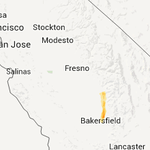
Hail Map for Oildale, CA
The Oildale, CA area has had 0 reports of on-the-ground hail by trained spotters, and has been under severe weather warnings 0 times during the past 12 months. Doppler radar has detected hail at or near Oildale, CA on 3 occasions.
| Name: | Oildale, CA |
| Where Located: | 3.7 miles N of Bakersfield, CA |
| Map: | Google Map for Oildale, CA |
| Population: | 32684 |
| Housing Units: | 13555 |
| More Info: | Search Google for Oildale, CA |
0
The Top Recent Hail Date for Oildale, CA is Saturday, March 11, 2023 (3rd out of 3)

Hail and Wind Damage Spotted near Oildale, CA
| Date / Time | Report Details |
|---|---|
| 10/25/2021 5:26 PM PDT |
 The severe thunderstorm warning for north central kern county will expire at 530 pm pdt, the storm which prompted the warning has weakened below severe limits, and has exited the warned area. therefore, the warning will be allowed to expire. however gusty winds and heavy rain are still possible with this thunderstorm. to report severe weather, contact your nearest law enforcement agency. they will relay your report to the national weather service hanford ca. The severe thunderstorm warning for north central kern county will expire at 530 pm pdt, the storm which prompted the warning has weakened below severe limits, and has exited the warned area. therefore, the warning will be allowed to expire. however gusty winds and heavy rain are still possible with this thunderstorm. to report severe weather, contact your nearest law enforcement agency. they will relay your report to the national weather service hanford ca.
|
| 10/25/2021 4:42 PM PDT |
 At 441 pm pdt, a severe thunderstorm was located 7 miles southwest of wasco, or 21 miles southwest of delano, moving southeast at 30 mph (radar indicated). Hazards include 60 mph wind gusts and quarter size hail. Hail damage to vehicles is expected. Expect wind damage to roofs, siding, and trees. At 441 pm pdt, a severe thunderstorm was located 7 miles southwest of wasco, or 21 miles southwest of delano, moving southeast at 30 mph (radar indicated). Hazards include 60 mph wind gusts and quarter size hail. Hail damage to vehicles is expected. Expect wind damage to roofs, siding, and trees.
|
| 4/24/2016 9:07 PM PDT |
 At 907 pm pdt, the public reported a severe thunderstorm producing quarter size hail. this storm was located over bakersfield, and moving southeast at 40 mph. At 907 pm pdt, the public reported a severe thunderstorm producing quarter size hail. this storm was located over bakersfield, and moving southeast at 40 mph.
|
Hail Maps for Oildale, CA

Connect with Interactive Hail Maps