

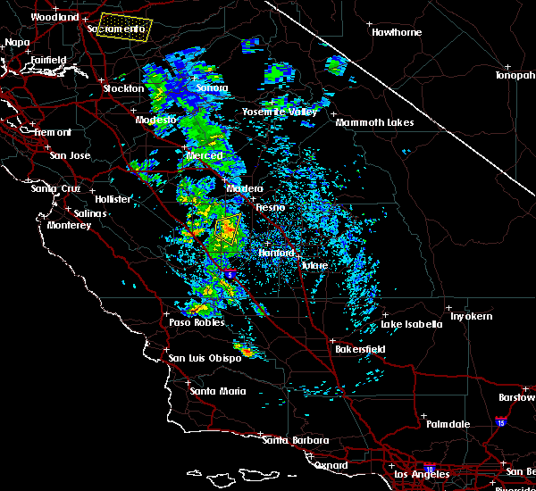
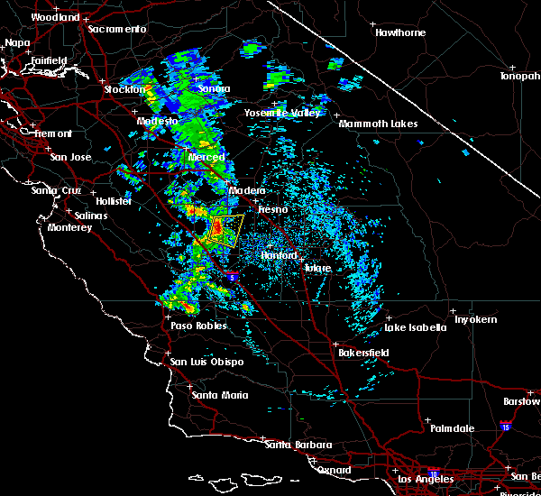
Hail Map for Raisin City, CA
The Raisin City, CA area has had 0 reports of on-the-ground hail by trained spotters, and has been under severe weather warnings 0 times during the past 12 months. Doppler radar has detected hail at or near Raisin City, CA on 3 occasions.
| Name: | Raisin City, CA |
| Where Located: | 11.6 miles SW of Fresno, CA |
| Map: | Google Map for Raisin City, CA |
| Population: | 380 |
| Housing Units: | 91 |
| More Info: | Search Google for Raisin City, CA |
5
The Top Recent Hail Date for Raisin City, CA is Saturday, March 11, 2023 (1st out of 3)

Hail and Wind Damage Spotted near Raisin City, CA
| Date / Time | Report Details |
|---|---|
| 3/12/2023 6:05 PM PDT |
 At 604 pm pdt, a severe thunderstorm was located near kerman, or 10 miles southwest of fresno, moving southeast at 15 mph (radar indicated). Hazards include half dollar size hail. Damage to vehicles is expected. Locations impacted include, fresno, kerman, raisin city and biola. At 604 pm pdt, a severe thunderstorm was located near kerman, or 10 miles southwest of fresno, moving southeast at 15 mph (radar indicated). Hazards include half dollar size hail. Damage to vehicles is expected. Locations impacted include, fresno, kerman, raisin city and biola.
|
| 3/12/2023 5:28 PM PDT |
 At 528 pm pdt, a severe thunderstorm was located near kerman, or 12 miles south of madera, moving southeast at 20 mph (radar indicated). Hazards include half dollar size hail. damage to vehicles is expected At 528 pm pdt, a severe thunderstorm was located near kerman, or 12 miles south of madera, moving southeast at 20 mph (radar indicated). Hazards include half dollar size hail. damage to vehicles is expected
|
| 3/11/2023 5:40 PM PDT |
 The severe thunderstorm warning for central fresno county will expire at 445 pm pst, the storm which prompted the warning has weakened below severe limits, and no longer poses an immediate threat to life or property. therefore, the warning will be allowed to expire. however small hail, gusty winds and heavy rain are still possible with this thunderstorm. The severe thunderstorm warning for central fresno county will expire at 445 pm pst, the storm which prompted the warning has weakened below severe limits, and no longer poses an immediate threat to life or property. therefore, the warning will be allowed to expire. however small hail, gusty winds and heavy rain are still possible with this thunderstorm.
|
| 3/11/2023 5:08 PM PDT |
 At 408 pm pst, a severe thunderstorm was located near kerman, or 16 miles southwest of fresno, moving east at 20 mph (radar indicated). Hazards include 60 mph wind gusts and quarter size hail. Hail damage to vehicles is expected. Expect wind damage to roofs, siding, and trees. At 408 pm pst, a severe thunderstorm was located near kerman, or 16 miles southwest of fresno, moving east at 20 mph (radar indicated). Hazards include 60 mph wind gusts and quarter size hail. Hail damage to vehicles is expected. Expect wind damage to roofs, siding, and trees.
|
| 3/10/2021 3:02 PM PST |
 At 302 pm pst, a severe thunderstorm was located over calwa, or near fresno, moving northeast at 30 mph (radar indicated). Hazards include 60 mph wind gusts and quarter size hail. Hail damage to vehicles is expected. expect wind damage to roofs, siding, and trees. Locations impacted include, fresno, raisin city, calwa, easton, bowles and caruthers. At 302 pm pst, a severe thunderstorm was located over calwa, or near fresno, moving northeast at 30 mph (radar indicated). Hazards include 60 mph wind gusts and quarter size hail. Hail damage to vehicles is expected. expect wind damage to roofs, siding, and trees. Locations impacted include, fresno, raisin city, calwa, easton, bowles and caruthers.
|
| 3/10/2021 2:46 PM PST |
 At 246 pm pst, a severe thunderstorm was located over easton, or 10 miles south of fresno, moving northeast at 30 mph (radar indicated). Hazards include 60 mph wind gusts and quarter size hail. Hail damage to vehicles is expected. Expect wind damage to roofs, siding, and trees. At 246 pm pst, a severe thunderstorm was located over easton, or 10 miles south of fresno, moving northeast at 30 mph (radar indicated). Hazards include 60 mph wind gusts and quarter size hail. Hail damage to vehicles is expected. Expect wind damage to roofs, siding, and trees.
|
| 9/11/2017 6:36 PM PDT |
 At 634 pm pdt, an area of thunderstorms, a few of them severe, were located near kerman, or 11 miles west of fresno, moving northwest at 45 mph (radar indicated). Hazards include 60 mph wind gusts and quarter size hail. Hail damage to vehicles is expected. expect wind damage to roofs, siding, and trees. in addition to frequent cloud to ground lightning, thunderstorms will contain heavy rain. ponding of water is likely on roads with localized flooding. Locations impacted include, fresno, clovis, lemoore, selma, parlier, kerman, kingsburg, lanare, bowles, calwa, biola, del rey, bonadelle ranchos-madera ranchos, easton, raisin city, fowler, san joaquin, riverdale, laton and caruthers. At 634 pm pdt, an area of thunderstorms, a few of them severe, were located near kerman, or 11 miles west of fresno, moving northwest at 45 mph (radar indicated). Hazards include 60 mph wind gusts and quarter size hail. Hail damage to vehicles is expected. expect wind damage to roofs, siding, and trees. in addition to frequent cloud to ground lightning, thunderstorms will contain heavy rain. ponding of water is likely on roads with localized flooding. Locations impacted include, fresno, clovis, lemoore, selma, parlier, kerman, kingsburg, lanare, bowles, calwa, biola, del rey, bonadelle ranchos-madera ranchos, easton, raisin city, fowler, san joaquin, riverdale, laton and caruthers.
|
| 9/11/2017 6:14 PM PDT |
 At 613 pm pdt, a severe thunderstorm was located near bowles, or 16 miles northwest of hanford, moving northwest at 45 mph (radar indicated). Hazards include 60 mph wind gusts and quarter size hail. Hail damage to vehicles is expected. expect wind damage to roofs, siding, and trees. In addition to dangerous cloud to ground lightning, thunderstorms will bring very heavy rain and ponding of water on roads with localized flooding. At 613 pm pdt, a severe thunderstorm was located near bowles, or 16 miles northwest of hanford, moving northwest at 45 mph (radar indicated). Hazards include 60 mph wind gusts and quarter size hail. Hail damage to vehicles is expected. expect wind damage to roofs, siding, and trees. In addition to dangerous cloud to ground lightning, thunderstorms will bring very heavy rain and ponding of water on roads with localized flooding.
|
| 9/11/2017 5:56 PM PDT |
 At 555 pm pdt, a severe thunderstorm was located near raisin city, or 16 miles south of fresno, moving northwest at 45 mph (radar indicated). Hazards include 60 mph wind gusts and quarter size hail. Hail damage to vehicles is expected. expect wind damage to roofs, siding, and trees. very heavy rain and frequent lightning is occurring with these thunderstorms. ponding of water is likely on roads with localized flooding. Locations impacted include, fresno, hanford, armona, bowles, home garden, easton, raisin city, lanare, riverdale, laton and caruthers. At 555 pm pdt, a severe thunderstorm was located near raisin city, or 16 miles south of fresno, moving northwest at 45 mph (radar indicated). Hazards include 60 mph wind gusts and quarter size hail. Hail damage to vehicles is expected. expect wind damage to roofs, siding, and trees. very heavy rain and frequent lightning is occurring with these thunderstorms. ponding of water is likely on roads with localized flooding. Locations impacted include, fresno, hanford, armona, bowles, home garden, easton, raisin city, lanare, riverdale, laton and caruthers.
|
| 9/11/2017 5:37 PM PDT |
 At 534 pm pdt, a severe thunderstorm was located near hanford, moving northwest at 45 mph (radar indicated). Hazards include quarter size hail. briefly heavy rain, frequent dangerous lighnting and gusty winds are likely with this thunderstorm At 534 pm pdt, a severe thunderstorm was located near hanford, moving northwest at 45 mph (radar indicated). Hazards include quarter size hail. briefly heavy rain, frequent dangerous lighnting and gusty winds are likely with this thunderstorm
|
| 4/27/2016 3:26 PM PDT |
 The severe thunderstorm warning for central fresno county will expire at 330 pm pdt, the storm which prompted the warning has weakened below severe limits, and no longer poses an immediate threat to life or property. therefore the warning will be allowed to expire. however small hail and heavy rain are still possible with this thunderstorm. The severe thunderstorm warning for central fresno county will expire at 330 pm pdt, the storm which prompted the warning has weakened below severe limits, and no longer poses an immediate threat to life or property. therefore the warning will be allowed to expire. however small hail and heavy rain are still possible with this thunderstorm.
|
| 4/27/2016 3:17 PM PDT |
 At 316 pm pdt, doppler radar indicated a severe thunderstorm capable of producing quarter size hail. this storm was located 7 miles northwest of lanare, or 22 miles southwest of fresno, moving southeast at 25 mph. locations impacted include, raisin city and five points. At 316 pm pdt, doppler radar indicated a severe thunderstorm capable of producing quarter size hail. this storm was located 7 miles northwest of lanare, or 22 miles southwest of fresno, moving southeast at 25 mph. locations impacted include, raisin city and five points.
|
| 4/27/2016 3:04 PM PDT |
 At 303 pm pdt, doppler radar indicated a severe thunderstorm capable of producing quarter size hail. this storm was located 10 miles southeast of tranquillity, or 24 miles southwest of fresno, and moving southeast at 25 mph. At 303 pm pdt, doppler radar indicated a severe thunderstorm capable of producing quarter size hail. this storm was located 10 miles southeast of tranquillity, or 24 miles southwest of fresno, and moving southeast at 25 mph.
|
Hail Maps for Raisin City, CA


Connect with Interactive Hail Maps