

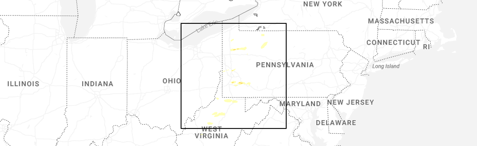
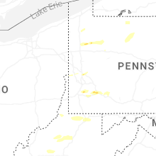
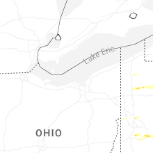
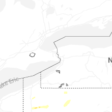
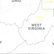
Hail Map for Wednesday, May 13, 2026
Number of Impacted Households on 5/13/2026
0
Impacted by 1" or Larger Hail
0
Impacted by 1.75" or Larger Hail
0
Impacted by 2.5" or Larger Hail
Square Miles of Populated Area Impacted on 5/13/2026
0
Impacted by 1" or Larger Hail
0
Impacted by 1.75" or Larger Hail
0
Impacted by 2.5" or Larger Hail
Cities Most Affected by Hail Storms of 5/13/2026
| Hail Size | Demographics of Zip Codes Affected | ||||||
|---|---|---|---|---|---|---|---|
| City | Count | Average | Largest | Pop Density | House Value | Income | Age |
Hail and Wind Damage Spotted on 5/13/2026
Filter by Report Type:Hail ReportsWind Reports
States Impacted
Idaho, Pennsylvania, West Virginia, Utah, New York, Montana, Wyoming, Maryland, Virginia, Nebraska, North DakotaIdaho
| Local Time | Report Details |
|---|---|
| 11:47 AM MDT | Mesonet station crii1 cotton ridg in cassia county ID, 30 miles SSE of Twin Falls, ID |
| 12:30 PM MDT | Mesonet station 2250 d5 sterling id-3 in bingham county ID, 46.8 miles SW of Idaho Falls, ID |
| 1:05 PM MDT | Mesonet station soest east butt in bingham county ID, 31.6 miles W of Idaho Falls, ID |
| 1:10 PM MDT | Mesonet station ato atomic cit in bingham county ID, 38.8 miles W of Idaho Falls, ID |
| 1:15 PM MDT | Mesonet station rrwbt relay ridge win in teton county ID, 38.3 miles ENE of Idaho Falls, ID |
| 1:15 PM MDT | Mesonet station rov 9 ssw mud lak in jefferson county ID, 29.1 miles WNW of Idaho Falls, ID |
| 1:15 PM MDT | Mesonet station rov 9 ssw mud lak in jefferson county ID, 29.1 miles WNW of Idaho Falls, ID |
| 1:15 PM MDT | Rover arl sit in jefferson county ID, 27.9 miles NW of Idaho Falls, ID |
| 1:20 PM MDT | Mesonet station soket kettle butt in bonneville county ID, 15 miles WNW of Idaho Falls, ID |
| 1:25 PM MDT | Mesonet station ham 1 wnw cama in jefferson county ID, 37.1 miles NNW of Idaho Falls, ID |
| 1:25 PM MDT | Mesonet station ham 1 wnw cama in jefferson county ID, 37.1 miles NNW of Idaho Falls, ID |
| 1:30 PM MDT | Mesonet station itde3 d6 camas i-1 in jefferson county ID, 37 miles NNW of Idaho Falls, ID |
| 1:30 PM MDT | Mesonet station 3004 d4 juniper interchange i-8 in oneida county ID, 81.5 miles ESE of Twin Falls, ID |
| 1:35 PM MDT | Mesonet station min 6 nw minidok in minidoka county ID, 47.9 miles ENE of Twin Falls, ID |
| 1:35 PM MDT | Mesonet station min 6 nw minidok in minidoka county ID, 47.9 miles ENE of Twin Falls, ID |
| 1:39 PM MDT | Power outage in clark county ID, 54.1 miles NW of Idaho Falls, ID |
| 1:40 PM MDT | Mesonet station pc371 medicine lodg in clark county ID, 61.3 miles NNW of Idaho Falls, ID |
| 1:45 PM MDT | Mesonet station 2983 d4 conner summit id-7 in cassia county ID, 50.6 miles ESE of Twin Falls, ID |
| 1:50 PM MDT | Mesonet station pc371 medicine lodg in clark county ID, 61.3 miles NNW of Idaho Falls, ID |
| 1:50 PM MDT | Mesonet station min 6 nw minidok in minidoka county ID, 47.9 miles ENE of Twin Falls, ID |
| 1:50 PM MDT | Mesonet station min 6 nw minidok in minidoka county ID, 47.9 miles ENE of Twin Falls, ID |
| 1:50 PM MDT | Power outages near minidok in minidoka county ID, 51.7 miles ENE of Twin Falls, ID |
| 1:52 PM MDT | Power outag in bonneville county ID, 6.2 miles ENE of Idaho Falls, ID |
| 1:54 PM MDT | Power outage in fremont county ID, 35.1 miles N of Idaho Falls, ID |
| 1:55 PM MDT | Mesonet station min 6 nw minidok in minidoka county ID, 47.9 miles ENE of Twin Falls, ID |
| 1:55 PM MDT | Mesonet station min 6 nw minidok in minidoka county ID, 47.9 miles ENE of Twin Falls, ID |
| 1:59 PM MDT | Asos station kbyi burley municipal airpor in minidoka county ID, 35.7 miles E of Twin Falls, ID |
| 2:00 PM MDT | Mesonet station pc141 canyon cree in madison county ID, 38.1 miles NE of Idaho Falls, ID |
| 2:00 PM MDT | Mesonet station 2979 d6 botts id-3 in teton county ID, 43.4 miles NE of Idaho Falls, ID |
| 2:00 PM MDT | Mesonet station pc371 medicine lodg in clark county ID, 61.3 miles NNW of Idaho Falls, ID |
| 2:00 PM MDT | Mesonet station rrwbt relay ridge win in teton county ID, 38.3 miles ENE of Idaho Falls, ID |
| 2:00 PM MDT | Numerous power outages fairview aberdeen sterling grandview area in bingham county ID, 55.5 miles SW of Idaho Falls, ID |
| 2:10 PM MDT | Mesonet station sodea dead man canyo in butte county ID, 52 miles W of Idaho Falls, ID |
| 2:10 PM MDT | Mesonet station bas base of howe pea in butte county ID, 50.3 miles WNW of Idaho Falls, ID |
| 2:10 PM MDT | Mesonet station pc371 medicine lodg in clark county ID, 61.3 miles NNW of Idaho Falls, ID |
| 2:15 PM MDT | Mesonet station san 12 e how in butte county ID, 41.1 miles WNW of Idaho Falls, ID |
| 2:15 PM MDT | Mesonet station san 12 e how in butte county ID, 41.1 miles WNW of Idaho Falls, ID |
| 2:15 PM MDT | Mesonet station dub 5 nne duboi in clark county ID, 52.2 miles N of Idaho Falls, ID |
| 2:15 PM MDT | Mesonet station dub 5 nne duboi in clark county ID, 52.2 miles N of Idaho Falls, ID |
| 2:20 PM MDT | Mesonet station sodea dead man canyo in butte county ID, 52 miles W of Idaho Falls, ID |
| 2:20 PM MDT | Mesonet station dea dead man canyo in butte county ID, 51.9 miles W of Idaho Falls, ID |
| 2:21 PM MDT | Power outag in minidoka county ID, 32.8 miles ENE of Twin Falls, ID |
| 2:25 PM MDT | Mesonet station dub 5 nne duboi in clark county ID, 52.2 miles N of Idaho Falls, ID |
| 2:25 PM MDT | Mesonet station dub 5 nne duboi in clark county ID, 52.2 miles N of Idaho Falls, ID |
| 2:31 PM MDT | Power outage in minidoka county ID, 50.9 miles ENE of Twin Falls, ID |
| 2:38 PM MDT | Asos station kllj challis airpor in custer county ID, 48 miles SSW of Salmon, ID |
| 2:40 PM MDT | Mesonet station sotab tabe in bingham county ID, 34.7 miles WSW of Idaho Falls, ID |
| 2:40 PM MDT | Mesonet station sotab tabe in bingham county ID, 34.7 miles WSW of Idaho Falls, ID |
| 2:45 PM MDT | Mesonet station blu blue dom in clark county ID, 56.4 miles NW of Idaho Falls, ID |
| 2:45 PM MDT | Mesonet station itdc4 d5 tilden flats us-2 in bingham county ID, 31.4 miles WSW of Idaho Falls, ID |
| 2:45 PM MDT | Mesonet station soblu blue dom in clark county ID, 56.9 miles NW of Idaho Falls, ID |
| 2:45 PM MDT | Mesonet station sum big southern butt in butte county ID, 49.6 miles W of Idaho Falls, ID |
| 2:49 PM MDT | Power outage in bingham county ID, 55.4 miles SW of Idaho Falls, ID |
| 2:58 PM MDT | Power outage in bingham county ID, 52.7 miles SW of Idaho Falls, ID |
| 3:00 PM MDT | Numeorus power outages in western jefferson count in jefferson county ID, 32.5 miles NW of Idaho Falls, ID |
| 3:00 PM MDT | Mesonet station 3004 d4 juniper interchange i-8 in oneida county ID, 81.5 miles ESE of Twin Falls, ID |
| 3:00 PM MDT | Mesonet station rwm inl radioactive waste mgm in butte county ID, 50.7 miles W of Idaho Falls, ID |
| 3:00 PM MDT | Mesonet station rwm inl radioactive waste mgm in butte county ID, 50.7 miles W of Idaho Falls, ID |
| 3:00 PM MDT | Mesonet station 3699 d6 inl puzzle us-20/us-2 in butte county ID, 42.6 miles W of Idaho Falls, ID |
| 3:00 PM MDT | Mesonet station 8419 d6 kettle butte us-2 in bonneville county ID, 19.4 miles WNW of Idaho Falls, ID |
| 3:00 PM MDT | Mesonet station 3255 d4 sweetzer summit i-8 in cassia county ID, 76.5 miles ESE of Twin Falls, ID |
| 3:00 PM MDT | Mesonet station ebr inl materials fuels comple in bingham county ID, 31.3 miles WNW of Idaho Falls, ID |
| 3:00 PM MDT | Mesonet station ebr inl materials fuels comple in bingham county ID, 31.3 miles WNW of Idaho Falls, ID |
| 3:03 PM MDT | Asos station kllj challis airpor in custer county ID, 48 miles SSW of Salmon, ID |
| 3:04 PM MDT | Power outage in power county ID, 64.4 miles SW of Idaho Falls, ID |
| 3:10 PM MDT | Mesonet station sobas base of howe pea in butte county ID, 50.3 miles WNW of Idaho Falls, ID |
| 3:14 PM MDT | Power outage in jefferson county ID, 18.3 miles NNW of Idaho Falls, ID |
| 3:15 PM MDT | Power outage in clark county ID, 51.1 miles NNW of Idaho Falls, ID |
| 3:16 PM MDT | Power outage in power county ID, 80.3 miles SSW of Idaho Falls, ID |
| 3:17 PM MDT | Power outage in jefferson county ID, 14.4 miles NW of Idaho Falls, ID |
| 3:20 PM MDT | Mesonet station rwm inl radioactive waste mgm in butte county ID, 50.7 miles W of Idaho Falls, ID |
| 3:20 PM MDT | Mesonet station ket kettle butt in bonneville county ID, 15 miles WNW of Idaho Falls, ID |
| 3:20 PM MDT | Mesonet station abe 1 ne aberdee in bingham county ID, 54.2 miles SW of Idaho Falls, ID |
| 3:25 PM MDT | Mesonet station ter 1 ne terreto in jefferson county ID, 30.6 miles NW of Idaho Falls, ID |
| 3:27 PM MDT | Power outag in bingham county ID, 25.7 miles SW of Idaho Falls, ID |
| 3:30 PM MDT | Mesonet station itdd3 d6 junction summit id-22/id-3 in butte county ID, 45.6 miles WNW of Idaho Falls, ID |
| 3:30 PM MDT | Mesonet station rob 1 n robert in jefferson county ID, 17.7 miles NNW of Idaho Falls, ID |
| 3:30 PM MDT | Mesonet station tra inl reactor tech comple in butte county ID, 47 miles W of Idaho Falls, ID |
| 3:37 PM MDT | Power outage in oneida county ID, 92.8 miles S of Idaho Falls, ID |
| 3:37 PM MDT | Power outage in oneida county ID, 90.5 miles S of Idaho Falls, ID |
| 3:39 PM MDT | Power outage in madison county ID, 39.3 miles NE of Idaho Falls, ID |
| 3:39 PM MDT | Mesonet station mofi1 moburg canyo in cassia county ID, 76.4 miles ESE of Twin Falls, ID |
| 3:40 PM MDT | Mesonet station san 12 e how in butte county ID, 41.1 miles WNW of Idaho Falls, ID |
| 3:40 PM MDT | Mesonet station san 12 e how in butte county ID, 41.1 miles WNW of Idaho Falls, ID |
| 3:40 PM MDT | Mesonet station pc374 reno gulc in clark county ID, 51.3 miles NW of Idaho Falls, ID |
| 3:45 PM MDT | Mesonet station 3306 d6 osgood i-1 in jefferson county ID, 11.3 miles NNW of Idaho Falls, ID |
| 3:45 PM MDT | Mesonet station sosmc specific manufacturing capabili in butte county ID, 42.8 miles NW of Idaho Falls, ID |
| 3:49 PM MDT | Power outage in bingham county ID, 24 miles SW of Idaho Falls, ID |
| 3:50 PM MDT | Mesonet station lof inl specific manufacturin in butte county ID, 42.8 miles NW of Idaho Falls, ID |
| 3:52 PM MDT | Power outage in butte county ID, 52 miles WNW of Idaho Falls, ID |
| 3:53 PM MDT | Asos station krxe rexburg-madison airpor in madison county ID, 26.3 miles NNE of Idaho Falls, ID |
| 3:54 PM MDT | Power outage in jefferson county ID, 36.2 miles NNW of Idaho Falls, ID |
| 3:54 PM MDT | Asos station krxe rexburg-madison airpor in madison county ID, 26.3 miles NNE of Idaho Falls, ID |
| 3:54 PM MDT | Mesonet station pbui1 potter butt in blaine county ID, 65.2 miles NE of Twin Falls, ID |
| 3:55 PM MDT | Power outag in bingham county ID, 32.7 miles SW of Idaho Falls, ID |
| 3:57 PM MDT | Power outage in madison county ID, 29.9 miles NNE of Idaho Falls, ID |
| 4:00 PM MDT | Mesonet station itdd9 d5 holbrook id-3 in oneida county ID, 96.4 miles ESE of Twin Falls, ID |
| 4:00 PM MDT | Mesonet station sug 2 nne sugar cit in madison county ID, 32 miles NNE of Idaho Falls, ID |
| 4:03 PM MDT | Power outage in jefferson county ID, 14.1 miles NNE of Idaho Falls, ID |
| 4:08 PM MDT | Power outage in bonneville county ID, 9.9 miles NNW of Idaho Falls, ID |
| 4:09 PM MDT | Power outage in jefferson county ID, 16.3 miles NNW of Idaho Falls, ID |
| 4:10 PM MDT | Mesonet station pc497 station canyo in oneida county ID, 82.2 miles S of Idaho Falls, ID |
| 4:10 PM MDT | Mesonet station pc130 cub rive in franklin county ID, 89.9 miles N of Salt Lake City, UT |
| 4:10 PM MDT | Power outag in bannock county ID, 44.8 miles SSW of Idaho Falls, ID |
| 4:11 PM MDT | Power outage in franklin county ID, 87.1 miles N of Salt Lake City, UT |
| 4:13 PM MDT | Power outage in bear lake county ID, 77.9 miles SSE of Idaho Falls, ID |
| 4:14 PM MDT | Power outage in bingham county ID, 43.7 miles SW of Idaho Falls, ID |
| 4:15 PM MDT | Mesonet station grei 1 nw nite in caribou county ID, 68.8 miles SSE of Idaho Falls, ID |
| 4:15 PM MDT | Mesonet station itdb6 d5 treasureton summit id-3 in franklin county ID, 83.3 miles S of Idaho Falls, ID |
| 4:20 PM MDT | Mesonet station pc639 mink cree in franklin county ID, 88.5 miles S of Idaho Falls, ID |
| 4:20 PM MDT | Mesonet station pc362 oneida narrow in franklin county ID, 85.1 miles S of Idaho Falls, ID |
| 4:23 PM MDT | Power outage in jefferson county ID, 16 miles N of Idaho Falls, ID |
| 4:27 PM MDT | Power outage in bonneville county ID, 6.2 miles ENE of Idaho Falls, ID |
| 4:29 PM MDT | Power outag in jefferson county ID, 14.1 miles NNE of Idaho Falls, ID |
| 4:30 PM MDT | Mesonet station pc219 galbrait in bonneville county ID, 10.1 miles ESE of Idaho Falls, ID |
| 4:31 PM MDT | Power outag in bannock county ID, 48.9 miles SSW of Idaho Falls, ID |
| 4:40 PM MDT | Chain reaction mulit-vehcile crash on idaho highway 34. several people injure in caribou county ID, 59.3 miles SSE of Idaho Falls, ID |
| 4:40 PM MDT | Power outage in fremont county ID, 72.3 miles NNE of Idaho Falls, ID |
| 4:40 PM MDT | Power outage in franklin county ID, 88.6 miles S of Idaho Falls, ID |
| 4:41 PM MDT | Power outag in bear lake county ID, 83.7 miles SSE of Idaho Falls, ID |
| 4:41 PM MDT | Power outag in bear lake county ID, 77.5 miles SSE of Idaho Falls, ID |
| 4:47 PM MDT | Power outage in bingham county ID, 46.8 miles SW of Idaho Falls, ID |
| 4:50 PM MDT | Mesonet station pc506 sheep creek hill in bear lake county ID, 91 miles SSE of Idaho Falls, ID |
| 4:53 PM MDT | Storm damage reported in cassia county ID, 34.7 miles E of Twin Falls, ID |
| 5:11 PM MDT | Power outages - hibbard are in madison county ID, 28 miles NNE of Idaho Falls, ID |
| 5:12 PM MDT | Power outag in jefferson county ID, 13.7 miles NNE of Idaho Falls, ID |
| 5:15 PM MDT | Mesonet station itde1 d5 blackfoot river bridge id-3 in caribou county ID, 52 miles SSE of Idaho Falls, ID |
| 5:25 PM MDT | Power outag in teton county ID, 48.3 miles NE of Idaho Falls, ID |
| 5:40 PM MDT | Mesonet station 2983 d4 conner summit id-7 in cassia county ID, 50.6 miles ESE of Twin Falls, ID |
| 5:45 PM MDT | Itd mesonet near yale itd1 in cassia county ID, 54.8 miles E of Twin Falls, ID |
| 6:00 PM MDT | Trees blown over from strong winds around 6 pm. tree fell on truc in blaine county ID, 78.5 miles N of Twin Falls, ID |
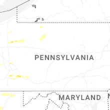
Pennsylvania
| Local Time | Report Details |
|---|---|
| 1:50 PM EDT | Quarter sized hail reported near Franklin, PA, 66.9 miles N of Pittsburgh, PA |
| 2:14 PM EDT | Quarter sized hail reported near Venus, PA, 70.5 miles NNE of Pittsburgh, PA |
| 2:22 PM EDT | Quarter sized hail reported near Clarion, PA, 62 miles NNE of Pittsburgh, PA |
| 3:15 PM EDT | Quarter sized hail reported near Venetia, PA, 13 miles S of Pittsburgh, PA, the hail lasted for 5 minutes. |
| 3:51 PM EDT | Quarter sized hail reported near West Newton, PA, 19.8 miles SE of Pittsburgh, PA |
| 3:55 PM EDT | Quarter sized hail reported near West Newton, PA, 20.2 miles SE of Pittsburgh, PA |
| 4:30 PM EDT | Quarter sized hail reported near Stahlstown, PA, 40.5 miles ESE of Pittsburgh, PA, time estimated via radar. |
| 5:00 PM EDT | Large tree down blocking charleston road; car ran into tre in tioga county PA, 73.7 miles NNE of State College, PA |
| 5:09 PM EDT | Tree on wire in tioga county PA, 74.7 miles NNE of State College, PA |
| 5:30 PM EDT | Wire down and sparkin in lycoming county PA, 56.2 miles NNE of State College, PA |
| 6:05 PM EDT | Corrects previous tstm wnd dmg report from 2 ene blain. wires came down on a combin in perry county PA, 36.6 miles SSE of State College, PA |
| 6:05 PM EDT | Corrects previous tstm wnd dmg report from 2 ene blain. wires came down on a combin in perry county PA, 36.6 miles SSE of State College, PA |
| 7:07 PM EDT | Steeple blown down off churc in perry county PA, 43.7 miles SE of State College, PA |
| 7:15 PM EDT | Tree down blocking both lanes. no wire in perry county PA, 47.7 miles ESE of State College, PA |
| 7:40 PM EDT | Tree down on sidewal in dauphin county PA, 64.7 miles SE of State College, PA |
| 7:40 PM EDT | Trees dow in dauphin county PA, 61 miles SE of State College, PA |
| 7:45 PM EDT | Trees dow in dauphin county PA, 65.2 miles ESE of State College, PA |
| 7:50 PM EDT | Trees dow in dauphin county PA, 66.9 miles ESE of State College, PA |
| 8:00 PM EDT | Tree dow in york county PA, 44.7 miles NNW of Baltimore, MD |
| 8:10 PM EDT | Tree dow in lebanon county PA, 76.9 miles ESE of State College, PA |
| 8:20 PM EDT | Wires dow in york county PA, 46.4 miles N of Baltimore, MD |
| 8:25 PM EDT | Tree and wires dow in berks county PA, 73.5 miles SSW of Scranton, PA |
| 8:35 PM EDT | Tree fell on wire in york county PA, 38.7 miles N of Baltimore, MD |
| 8:40 PM EDT | Tree dow in berks county PA, 69.9 miles SSW of Scranton, PA |
West Virginia
| Local Time | Report Details |
|---|---|
| 3:10 PM EDT | A tree was reported blown ove in wetzel county WV, 64.6 miles NW of Elkins, WV |
| 3:58 PM EDT | Quarter sized hail reported near Arnoldsburg, WV, 42.6 miles NE of Charleston, WV, time estimated by radar. |
| 4:05 PM EDT | Tree down catawba roa in marion county WV, 42.9 miles NNW of Elkins, WV |
| 4:12 PM EDT | Multiple trees down on pricketts fort roa in marion county WV, 42.7 miles NNW of Elkins, WV |
| 4:15 PM EDT | Quarter sized hail reported near Morgantown, WV, 43.2 miles N of Elkins, WV, report from mping: quarter (1.00 in.). |
| 4:18 PM EDT | Trees down on smithtown road near 11 in monongalia county WV, 46.4 miles N of Elkins, WV |
| 4:18 PM EDT | Tree down on squirrel run roa in marion county WV, 38.6 miles NNW of Elkins, WV |
| 4:32 PM EDT | Complete metal roof uplift of smokin jacks bar & gril in preston county WV, 40.7 miles N of Elkins, WV |
| 4:39 PM EDT | Quarter sized hail reported near Morgantown, WV, 46.3 miles N of Elkins, WV |
| 4:45 PM EDT | Large tree uproote in preston county WV, 32.5 miles N of Elkins, WV |
| 5:40 PM EDT | Trees down near d street and w piedmont in mineral county WV, 58.5 miles NE of Elkins, WV |
| 5:59 PM EDT | A couple reports of trees and large limbs down in romne in hampshire county WV, 65.3 miles ENE of Elkins, WV |
| 6:23 PM EDT | Tree down on a power line at the intersection of ewing st. and dawson s in morgan county WV, 83.3 miles SSW of State College, PA |
| 6:36 PM EDT | Tree was reported down on underwood road in lewisburg west virginia by the 911 call cente in greenbrier county WV, 45.8 miles NW of Roanoke, VA |
| 6:50 PM EDT | Tree down at cherry run road and hedgesville road in berkeley county WV, 79.1 miles WNW of Baltimore, MD |
| 7:00 PM EDT | Tree down at paynes ford road and trent arden cour in berkeley county WV, 71.5 miles W of Baltimore, MD |
Utah
| Local Time | Report Details |
|---|---|
| 1:20 PM MDT | Mesonet station ut23 i-15/2400 in salt lake county UT, 2.8 miles SSW of Salt Lake City, UT |
| 1:35 PM MDT | Awos station ksvr slc arpt no. in salt lake county UT, 11 miles SSW of Salt Lake City, UT |
| 2:00 PM MDT | Mesonet station wdypk windy pea in summit county UT, 45.9 miles E of Salt Lake City, UT |
| 2:00 PM MDT | Mesonet station pc298 the hea in morgan county UT, 27.4 miles NNE of Salt Lake City, UT |
| 2:06 PM MDT | Awos station ku16 14 sw lakesid in box elder county UT, 65 miles WNW of Salt Lake City, UT |
| 2:10 PM MDT | Mesonet station utwdl i-80 at mp 68 west dell in tooele county UT, 47.9 miles W of Salt Lake City, UT |
| 2:30 PM MDT | Mesonet station utedl i-80 at mp 71 east dell in tooele county UT, 45.8 miles W of Salt Lake City, UT |
| 2:35 PM MDT | Mesonet station gni gunnison islan in box elder county UT, 63.8 miles NW of Salt Lake City, UT |
| 2:40 PM MDT | Mesonet station hatut hat islan in box elder county UT, 42.5 miles WNW of Salt Lake City, UT |
| 2:42 PM MDT | Mesonet station rsbu1 rosebu in box elder county UT, 79.4 miles SE of Twin Falls, ID |
| 2:44 PM MDT | Mesonet station up068 mars in box elder county UT, 51.8 miles NW of Salt Lake City, UT |
| 2:45 PM MDT | Mesonet station wdypk windy pea in summit county UT, 45.9 miles E of Salt Lake City, UT |
| 2:50 PM MDT | Mesonet station utpcr pioneer crossin in utah county UT, 26.9 miles S of Salt Lake City, UT |
| 2:50 PM MDT | Mesonet station cw9635 salt lake cit in wasatch county UT, 32.8 miles SSE of Salt Lake City, UT |
| 2:55 PM MDT | Mesonet station gni gunnison islan in box elder county UT, 63.8 miles NW of Salt Lake City, UT |
| 2:55 PM MDT | Mesonet station fps flight park sout in utah county UT, 20.7 miles S of Salt Lake City, UT |
| 3:00 PM MDT | Mesonet station fg011 tinti in juab county UT, 62.8 miles SSW of Salt Lake City, UT |
| 3:00 PM MDT | Mesonet station freut fremont island - miller hil in weber county UT, 35.5 miles NW of Salt Lake City, UT |
| 3:00 PM MDT | Mesonet station utalp point of the mountai in utah county UT, 21.4 miles S of Salt Lake City, UT |
| 3:00 PM MDT | Mesonet station dw9435 drape in salt lake county UT, 19.3 miles S of Salt Lake City, UT |
| 3:05 PM MDT | Mesonet station freut fremont island - miller hil in weber county UT, 35.5 miles NW of Salt Lake City, UT |
| 3:10 PM MDT | Mesonet station pc482 bull claim hil in sevier county UT, 9.3 miles NE of Monroe, UT |
| 3:15 PM MDT | Public photo of large tree split and downed along the 9 line trail on 900 s near 300 in salt lake county UT, 0.8 miles SSE of Salt Lake City, UT |
| 3:15 PM MDT | Trees and power lines dow in salt lake county UT, 3.7 miles SE of Salt Lake City, UT |
| 3:20 PM MDT | Mesonet station utstr s-turns - big cottonwood canyo in salt lake county UT, 12.6 miles SE of Salt Lake City, UT |
| 3:20 PM MDT | Mesonet station utcur curlew junctio in box elder county UT, 82.6 miles ESE of Twin Falls, ID |
| 3:20 PM MDT | Mesonet station utqry parleys canyon quarr in salt lake county UT, 6.5 miles ESE of Salt Lake City, UT |
| 3:20 PM MDT | Mesonet station pc490 kennecott rd lake poin in tooele county UT, 19.4 miles WSW of Salt Lake City, UT |
| 3:20 PM MDT | Mesonet station pc597 huntington s in emery county UT, 22 miles SSW of Price, UT |
| 3:20 PM MDT | Mesonet station utoly i-215 at olympus cov in salt lake county UT, 7.2 miles SE of Salt Lake City, UT |
| 3:20 PM MDT | Mesonet station agd alta - guard hous in salt lake county UT, 17.5 miles SE of Salt Lake City, UT |
| 3:25 PM MDT | Semi blown over near mile post 77 along i-8 in tooele county UT, 39.5 miles W of Salt Lake City, UT |
| 3:30 PM MDT | Mesonet station utckh chaulk hil in box elder county UT, 87.8 miles NNW of Salt Lake City, UT |
| 3:30 PM MDT | Mesonet station ut28 tremonto in box elder county UT, 65.8 miles NNW of Salt Lake City, UT |
| 3:30 PM MDT | Mesonet station utecy i-80 at mp 134 east canyo in salt lake county UT, 9.4 miles E of Salt Lake City, UT |
| 3:30 PM MDT | Mesonet station ut201 sr-201 at i-8 in tooele county UT, 18.2 miles W of Salt Lake City, UT |
| 3:30 PM MDT | Mesonet station utnbc i-15 north brigham cit in box elder county UT, 57.4 miles N of Salt Lake City, UT |
| 3:30 PM MDT | Mesonet station ut31 i-80 at mp 7 in tooele county UT, 38.4 miles W of Salt Lake City, UT |
| 3:30 PM MDT | Mesonet station pc172 junction sout in piute county UT, 29 miles SSW of Monroe, UT |
| 3:30 PM MDT | Mesonet station utbig big mountain pas in salt lake county UT, 13.4 miles ENE of Salt Lake City, UT |
| 3:30 PM MDT | Mesonet station ut215 i-215 at i-8 in salt lake county UT, 3.3 miles WNW of Salt Lake City, UT |
| 3:40 PM MDT | Mesonet station utcur curlew junctio in box elder county UT, 82.6 miles ESE of Twin Falls, ID |
| 3:40 PM MDT | Mesonet station uttol tollgate canyo in summit county UT, 21.9 miles E of Salt Lake City, UT |
| 3:40 PM MDT | Mesonet station pc123 murray's hil in cache county UT, 58.8 miles N of Salt Lake City, UT |
| 3:50 PM MDT | Mesonet station ut30 sr-3 in box elder county UT, 70.8 miles N of Salt Lake City, UT |
| 3:50 PM MDT | Mesonet station pc254 the elbo in carbon county UT, 17.4 miles WNW of Price, UT |
| 3:50 PM MDT | Mesonet station utpow sr-158 at mp 11.5 powder mounta in weber county UT, 43.2 miles N of Salt Lake City, UT |
| 3:54 PM MDT | Asos station klgu logan-cache airpor in cache county UT, 70.5 miles N of Salt Lake City, UT |
| 4:00 PM MDT | Multi-vehicle crash due to strong thunderstorm wind in cache county UT, 80.2 miles N of Salt Lake City, UT |
| 4:00 PM MDT | Swath of tree damage and downed power lines from the logan airport to smithfiel in cache county UT, 73.2 miles N of Salt Lake City, UT |
| 4:00 PM MDT | Mesonet station smt south mountai in tooele county UT, 34.4 miles SW of Salt Lake City, UT |
| 4:00 PM MDT | Mesonet station lgp logan pea in cache county UT, 66.2 miles N of Salt Lake City, UT |
| 4:00 PM MDT | Mesonet station lofty trial lak in summit county UT, 52.4 miles E of Salt Lake City, UT |
| 4:00 PM MDT | Mesonet station pc358 hansel valle in box elder county UT, 85.6 miles NNW of Salt Lake City, UT |
| 4:00 PM MDT | Mesonet station wdypk windy pea in summit county UT, 45.9 miles E of Salt Lake City, UT |
| 4:00 PM MDT | Mesonet station pc124 crow mountai in cache county UT, 76.7 miles N of Salt Lake City, UT |
| 4:10 PM MDT | Mesonet station utrmd us-91 at mp 39 richmon in cache county UT, 79.5 miles N of Salt Lake City, UT |
| 4:20 PM MDT | Mesonet station pc295 gunnison ridg in sanpete county UT, 51.1 miles NNE of Monroe, UT |
| 4:20 PM MDT | Mesonet station utusu us-89 at us in cache county UT, 67.8 miles N of Salt Lake City, UT |
| 4:26 PM MDT | Mesonet station fw8325 garden cit in rich county UT, 85.5 miles NNE of Salt Lake City, UT |
| 4:30 PM MDT | Mesonet station pc295 gunnison ridg in sanpete county UT, 51.1 miles NNE of Monroe, UT |
| 4:30 PM MDT | Mesonet station drrd dry ridg in duchesne county UT, 67.8 miles E of Salt Lake City, UT |
| 4:31 PM MDT | Mesonet station ur400 2.4 sw castle roc in summit county UT, 42.9 miles NE of Salt Lake City, UT |
| 4:36 PM MDT | Mesonet station ucl02 paradis in cache county UT, 54.6 miles N of Salt Lake City, UT |
| 4:45 PM MDT | Mesonet station psrim peter sinks ri in cache county UT, 82.5 miles NNE of Salt Lake City, UT |
| 4:50 PM MDT | Mesonet station utstv us-40 at starvatio in duchesne county UT, 42.8 miles NNE of Price, UT |
| 5:00 PM MDT | Mesonet station pc104 grantsville sout in tooele county UT, 34 miles WSW of Salt Lake City, UT |
| 5:00 PM MDT | Mesonet station pc098 gunnison reservio in sanpete county UT, 47.5 miles NNE of Monroe, UT |
| 5:10 PM MDT | Mesonet station pc338 horse have in juab county UT, 55.5 miles W of Price, UT |
| 5:15 PM MDT | Mesonet station ccput currant creek pea in wasatch county UT, 46 miles SE of Salt Lake City, UT |
| 5:15 PM MDT | Mesonet station ogp snowbasin - mount ogde in weber county UT, 30.4 miles N of Salt Lake City, UT |
| 5:30 PM MDT | Mesonet station pc291 scipio summi in millard county UT, 39.3 miles N of Monroe, UT |
| 5:30 PM MDT | Mesonet station pc367 east bearlak in rich county UT, 84.4 miles NNE of Salt Lake City, UT |
| 5:35 PM MDT | Mesonet station freut fremont island - miller hil in weber county UT, 35.5 miles NW of Salt Lake City, UT |
| 6:00 PM MDT | Mesonet station utmpk monument pea in emery county UT, 19.7 miles W of Price, UT |
| 6:10 PM MDT | Mesonet station pc349 nephi wes in juab county UT, 60.3 miles W of Price, UT |
New York
| Local Time | Report Details |
|---|---|
| 3:56 PM EDT | Tree down on wires on carter road in genev in ontario county NY, 44.1 miles WSW of Syracuse, NY |
| 4:07 PM EDT | Tree and wires down on route 41 in wayne county NY, 36.6 miles W of Syracuse, NY |
| 4:30 PM EDT | Large tree and wires down on potter road as per county dispatch feed. radar-estimated tim in cayuga county NY, 22.3 miles W of Syracuse, NY |
| 4:30 PM EDT | Wires down in one location... tree down in another... both in vicinity of adams street as per county dispatch feed. radar-estimated tim in cayuga county NY, 21.8 miles WSW of Syracuse, NY |
| 4:55 PM EDT | Wires down. radar-estimated tim in onondaga county NY, 12 miles NW of Syracuse, NY |
| 5:05 PM EDT | Wires down. radar-estimated tim in onondaga county NY, 4.7 miles NW of Syracuse, NY |
| 5:30 PM EDT | Tree and wires down. radar-estimated tim in onondaga county NY, 9.2 miles ESE of Syracuse, NY |
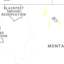
Montana
| Local Time | Report Details |
|---|---|
| 2:05 PM MDT | Asos station kdln dillon airpor in beaverhead county MT, 65.9 miles E of Salmon, ID |
| 2:15 PM MDT | Mesonet station mtm70 3.0 ne dillon (mt-meso in beaverhead county MT, 64 miles E of Salmon, ID |
| 2:16 PM MDT | Asos station kdln dillon airpor in beaverhead county MT, 65.9 miles E of Salmon, ID |
| 2:30 PM MDT | Corrects previous non-tstm wnd gst report from 1 n raynolds pass. mesonet station mtray raynolds pass (mt dot in madison county MT, 68.9 miles SSW of Bozeman, MT |
| 2:35 PM MDT | Awos station krvf 1 ese twin bridge in madison county MT, 62.3 miles W of Bozeman, MT |
| 2:45 PM MDT | Mesonet station mtbwg browning (mt dot in glacier county MT, 63 miles E of Whitefish, MT |
| 2:45 PM MDT | Mesonet station mtm76 cascade e md in cascade county MT, 21.5 miles SW of Great Falls, MT |
| 2:47 PM MDT | Awos station k1im indi in cascade county MT, 15 miles SSW of Great Falls, MT |
| 2:55 PM MDT | Awos station k1am alph in cascade county MT, 28.5 miles ESE of Great Falls, MT |
| 2:56 PM MDT | Asos station kgtf great falls airpor in cascade county MT, 4.3 miles SW of Great Falls, MT |
| 3:00 PM MDT | Mesonet station mtgys geyser (mt dot in judith basin county MT, 42.6 miles ESE of Great Falls, MT |
| 3:00 PM MDT | Mesonet station mtbwg browning (mt dot in glacier county MT, 63 miles E of Whitefish, MT |
| 3:00 PM MDT | Mt mesonet belt n in cascade county MT, 14.4 miles ESE of Great Falls, MT |
| 3:00 PM MDT | Montana mesonet highwood benc in chouteau county MT, 22.4 miles ENE of Great Falls, MT |
| 3:01 PM MDT | Awos station kgfa malmstrom af in cascade county MT, 6.4 miles E of Great Falls, MT |
| 3:09 PM MDT | Asos station kgtf great falls airpor in cascade county MT, 4.3 miles SW of Great Falls, MT |
| 3:15 PM MDT | Mesonet station mtm45 3.2 sw loma (mt-meso in chouteau county MT, 44.8 miles NE of Great Falls, MT |
| 3:16 PM MDT | Mesonet station mttos toston bridge us-287 mp 87. in broadwater county MT, 39.8 miles NNW of Bozeman, MT |
| 3:22 PM MDT | Asos station kdln dillon airpor in beaverhead county MT, 65.9 miles E of Salmon, ID |
| 3:30 PM MDT | Ambient weather station: my weather statio in chouteau county MT, 47.3 miles E of Great Falls, MT |
| 3:35 PM MDT | Mesonet station dvi04529 fort bento in chouteau county MT, 34 miles ENE of Great Falls, MT |
| 3:40 PM MDT | Carter n montana mesonet measured a 61 mph wind gus in chouteau county MT, 38.4 miles NNE of Great Falls, MT |
| 3:45 PM MDT | Mesonet station mtelv 3.3 e livingston (mt dot in park county MT, 25.8 miles E of Bozeman, MT |
| 3:45 PM MDT | Mesonet station mtlrh livingston river hil in park county MT, 23.5 miles E of Bozeman, MT |
| 3:53 PM MDT | Asos station klvm livingsto in park county MT, 29.2 miles E of Bozeman, MT |
| 3:55 PM MDT | Awos station k79s 1 ne fort bento in chouteau county MT, 39.1 miles NE of Great Falls, MT |
| 4:00 PM MDT | Mesonet station gw3478 tctibe in liberty county MT, 63 miles N of Great Falls, MT |
| 4:00 PM MDT | Corrects previous tstm wnd gst report from 11 sse big sandy. montana mesonet big sandy s in chouteau county MT, 39.9 miles SSW of Havre, MT |
| 4:00 PM MDT | Mesonet station gw4098 tiber dam twelve s in liberty county MT, 51.3 miles NNE of Great Falls, MT |
| 4:00 PM MDT | Mesonet station gw3487 tiber dam six eas in liberty county MT, 57.5 miles NNE of Great Falls, MT |
| 4:00 PM MDT | Mesonet station gw6710 meadowlan in chouteau county MT, 49.3 miles NE of Great Falls, MT |
| 4:00 PM MDT | Mesonet station mtspd springdale i-90 mp 352. in park county MT, 38 miles E of Bozeman, MT |
| 4:00 PM MDT | Mesonet station mtlrh livingston river hil in park county MT, 23.5 miles E of Bozeman, MT |
| 4:15 PM MDT | Mesonet station gw4015 chester four n in liberty county MT, 55.9 miles W of Havre, MT |
| 4:15 PM MDT | Awos station k6s0 big timbe in sweet grass county MT, 52.1 miles E of Bozeman, MT |
| 4:15 PM MDT | Mesonet station gw6710 meadowlan in chouteau county MT, 49.3 miles NE of Great Falls, MT |
| 4:20 PM MDT | Big sandy nw montana mesonet measured a 85 mph wind gus in chouteau county MT, 36.9 miles SW of Havre, MT |
| 4:30 PM MDT | Mesonet station gw4079 inverness ten south southeas in hill county MT, 45.9 miles W of Havre, MT |
| 4:30 PM MDT | Mesonet station dw4821 cheste in liberty county MT, 59.1 miles WNW of Havre, MT |
| 4:30 PM MDT | Mesonet station mtinv inverness (mt dot in hill county MT, 44.9 miles W of Havre, MT |
| 4:30 PM MDT | Mesonet station ew1931 rudyar in hill county MT, 41.5 miles WSW of Havre, MT |
| 4:30 PM MDT | Mesonet station gw3530 rudyard eleven sout in hill county MT, 42.2 miles WSW of Havre, MT |
| 4:31 PM MDT | Mesonet station mthls harlowton south us-191 mp 22. in sweet grass county MT, 62 miles ENE of Bozeman, MT |
| 4:35 PM MDT | Mesonet station dbym8 derby mountai in sweet grass county MT, 56.3 miles E of Bozeman, MT |
| 4:40 PM MDT | Mesonet station gw6390 gildford 6s in hill county MT, 26.9 miles W of Havre, MT |
| 4:45 PM MDT | Mesonet station dvi02964 havr in hill county MT, 13 miles WNW of Havre, MT |
| 4:45 PM MDT | Mesonet station mtm06 arc-n havr in hill county MT, 7.3 miles SW of Havre, MT |
| 4:45 PM MDT | Mesonet station gw6393 kremlin 3es in hill county MT, 16 miles W of Havre, MT |
| 4:45 PM MDT | Mesonet station gw0416 jopli in liberty county MT, 50 miles W of Havre, MT |
| 4:46 PM MDT | Asos station khvr havre airpor in hill county MT, 4.5 miles W of Havre, MT |
| 4:53 PM MDT | Trained spotter reported a 62 mph wind gus in hill county MT, 3.2 miles W of Havre, MT |
| 5:15 PM MDT | Mesonet station mtchk chinook us-2 mp 403. in blaine county MT, 20 miles E of Havre, MT |
| 5:40 PM MDT | Mesonet station dw8455 livingsto in park county MT, 25.6 miles ESE of Bozeman, MT |
| 5:45 PM MDT | Mesonet station beacon hill us 87 mp 35 (mt dot in fergus county MT, 77.9 miles N of Billings, MT |
| 5:53 PM MDT | Asos station klvm livingsto in park county MT, 29.2 miles E of Bozeman, MT |
| 5:55 PM MDT | Awos station k00u 2 wnw hardi in big horn county MT, 41 miles E of Billings, MT |
| 5:55 PM MDT | Winnett sw station (wiem8 in petroleum county MT, 81.9 miles N of Billings, MT |
| 5:59 PM MDT | Ambient weather station: 2flagsweathe in chouteau county MT, 56.2 miles S of Havre, MT |
| 6:00 PM MDT | Montana mesonet big sandy s in chouteau county MT, 39.9 miles SSW of Havre, MT |
| 6:00 PM MDT | Mesonet station mtelv 3.3 e livingston (mt dot in park county MT, 25.8 miles E of Bozeman, MT |
| 6:00 PM MDT | Mesonet station mtwin winnett mt-200 mp 136. in petroleum county MT, 85 miles N of Billings, MT |
| 6:00 PM MDT | Mesonet station mtlrh livingston river hil in park county MT, 23.5 miles E of Bozeman, MT |
| 6:05 PM MDT | War horse nw station (wrhm8 in petroleum county MT, 93.7 miles N of Billings, MT |
| 6:15 PM MDT | Mesonet station mtspd springdale i-90 mp 352. in park county MT, 38 miles E of Bozeman, MT |
| 6:41 PM MDT | Dry blood creek raw in petroleum county MT, 100.8 miles N of Billings, MT |
| 7:08 PM MDT | Mesonet station ssmm8 south sawmill cree in garfield county MT, 60.4 miles SW of Glasgow, MT |
| 7:15 PM MDT | Sun prairie station (snpm8 in phillips county MT, 56.6 miles WSW of Glasgow, MT |
| 7:15 PM MDT | Mesonet station au397 big timbe in sweet grass county MT, 52.1 miles E of Bozeman, MT |
| 7:22 PM MDT | Mesonet station fslm8 fishtai in stillwater county MT, 56.2 miles WSW of Billings, MT |
| 7:35 PM MDT | Awos station k6s8 2 nne laure in yellowstone county MT, 13.6 miles WSW of Billings, MT |
| 7:53 PM MDT | Asos station kbil billing in yellowstone county MT, 2.4 miles WNW of Billings, MT |
| 8:12 PM MDT | Mesonet station tt453 craz in park county MT, 45.7 miles NE of Bozeman, MT |
| 8:50 PM MDT | Larslan sw mesonet llnm in valley county MT, 30.6 miles NE of Glasgow, MT |
| 9:55 PM MDT | War horse sw mesonet wrhm in petroleum county MT, 93.8 miles N of Billings, MT |
| 10:00 PM MDT | Winnett sw mesonet wiem in petroleum county MT, 81.2 miles N of Billings, MT |
| 10:15 PM MDT | Corrects previous non-tstm wnd gst report from 1 nnw winnett. mesonet station mtwin winnett mt-200 mp 136. in petroleum county MT, 85 miles N of Billings, MT |
| 10:15 PM MDT | Corrects previous non-tstm wnd gst report from 5 wnw landusky. mesonet station mthay 6.1 sw hays (mt dot in phillips county MT, 61.6 miles SE of Havre, MT |
| 10:25 PM MDT | Valentine east mesonet vltm in petroleum county MT, 94 miles SW of Glasgow, MT |
| 10:35 PM MDT | Mosby nw mesonet mobm in petroleum county MT, 89.8 miles NNE of Billings, MT |
Wyoming
| Local Time | Report Details |
|---|---|
| 2:20 PM MDT | Mesonet station pc581 canyon compressio in uinta county WY, 71.4 miles NE of Salt Lake City, UT |
| 2:40 PM MDT | Mesonet station pc450 evanston nort in uinta county WY, 65.8 miles NE of Salt Lake City, UT |
| 2:40 PM MDT | Mesonet station av868 medicine butte mountai in uinta county WY, 65.3 miles NE of Salt Lake City, UT |
| 2:46 PM MDT | Mesonet station kmtr wy120 meeteetse rim (dot in park county WY, 89.4 miles NNW of Riverton, WY |
| 4:28 PM MDT | Asos station kevw evanston-uinta cnty airpor in uinta county WY, 57 miles NE of Salt Lake City, UT |
| 4:36 PM MDT | Mesonet station kfir first divid in uinta county WY, 67.3 miles ENE of Salt Lake City, UT |
| 4:36 PM MDT | Mesonet station av868 medicine butte mountai in uinta county WY, 65.3 miles NE of Salt Lake City, UT |
| 4:40 PM MDT | Mesonet station pc450 evanston nort in uinta county WY, 65.8 miles NE of Salt Lake City, UT |
| 4:46 PM MDT | Mesonet station wy33 coal roa in uinta county WY, 72.9 miles ENE of Salt Lake City, UT |
| 5:15 PM MDT | Mesonet station up146 7.8 ne carte in uinta county WY, 57.6 miles W of Rock Springs, WY |
| 5:38 PM MDT | Awos station kjac jackson airport (awos in teton county WY, 66.4 miles E of Idaho Falls, ID |
| 6:00 PM MDT | Mesonet station up199 7.5 w grange in uinta county WY, 46 miles W of Rock Springs, WY |
| 6:56 PM MDT | Mesonet station wy55 2.9 n banner (wydot in sheridan county WY, 71.1 miles WNW of Gillette, WY |
| 9:27 PM MDT | Asos station kshr sherida in sheridan county WY, 79.5 miles WNW of Gillette, WY |
Maryland
| Local Time | Report Details |
|---|---|
| 5:09 PM EDT | Trees down on broadford road and deer park hotel roa in garrett county MD, 43.6 miles NE of Elkins, WV |
| 5:42 PM EDT | Tree down at old waxler roa in mineral county WV, 59.3 miles NE of Elkins, WV |
| 6:57 PM EDT | One tree down in williamsport in washington county MD, 68.2 miles WNW of Baltimore, MD |
| 7:02 PM EDT | A few reports of trees and power lines down in hagerstow in washington county MD, 64.1 miles WNW of Baltimore, MD |
| 7:10 PM EDT | Tree down at the intersection of old kiln rd. and orndorff r in frederick county MD, 47.5 miles WNW of Baltimore, MD |
| 7:30 PM EDT | Tree down at the intersection of old kiln rd. and orndorff r in frederick county MD, 47.5 miles WNW of Baltimore, MD |
Virginia
| Local Time | Report Details |
|---|---|
| 6:33 PM EDT | Trained spotter measured wind gusts at 61 mp in frederick county VA, 86.9 miles ENE of Elkins, WV |
Nebraska
| Local Time | Report Details |
|---|---|
| 10:53 PM MDT | Asos station kcdr chadron airport - cdr. occured under a 26 dbz shower as it was collapsing. minimal lightning associated with i in dawes county NE, 72.8 miles NNE of Scottsbluff, NE |
North Dakota
| Local Time | Report Details |
|---|---|
| 5:31 AM CDT | Ndawn 10 meter peak wind gust measuremen in wells county ND, 59.6 miles NE of Bismarck, ND |
Connect with Interactive Hail Maps