

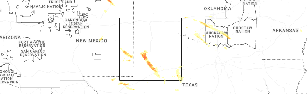
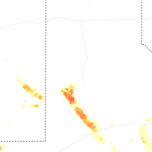
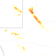
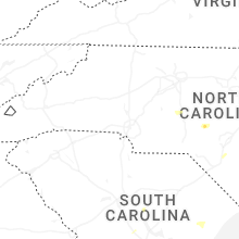
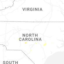
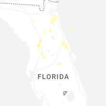
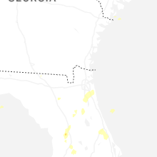
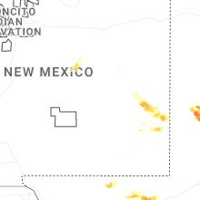
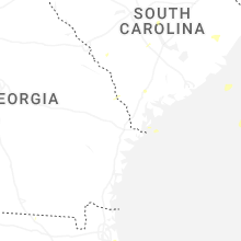
Hail Map for Thursday, May 29, 2025
Number of Impacted Households on 5/29/2025
0
Impacted by 1" or Larger Hail
0
Impacted by 1.75" or Larger Hail
0
Impacted by 2.5" or Larger Hail
Square Miles of Populated Area Impacted on 5/29/2025
0
Impacted by 1" or Larger Hail
0
Impacted by 1.75" or Larger Hail
0
Impacted by 2.5" or Larger Hail
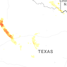
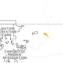
Cities Most Affected by Hail Storms of 5/29/2025
| Hail Size | Demographics of Zip Codes Affected | ||||||
|---|---|---|---|---|---|---|---|
| City | Count | Average | Largest | Pop Density | House Value | Income | Age |
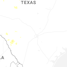
| Brownfield, TX | 3 | 2.83 | 3.50 | 22 | $44k | $27.6k | 34.7 |
Hail and Wind Damage Spotted on 5/29/2025
Filter by Report Type:Hail ReportsWind Reports
States Impacted
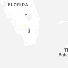
Florida, Alabama, South Carolina, Georgia, North Carolina, Oklahoma, Texas, New MexicoFlorida
| Local Time | Report Details |
|---|---|
| 9:07 AM EDT | Line down on a and n roa in gadsden county FL, 36.5 miles WNW of Tallahassee, FL |
| 2:45 PM EDT | *** 1 fatal *** corrects previous tstm wnd dmg report from 2 ene ocala airport. marion county emergency management reports one fatality resulting from a snapped tree al in marion county FL, 66.6 miles NW of Orlando, FL |
| 3:45 PM EDT | *** 1 fatal *** marion county emergency management reports one fatality resulting from a snapped tree along southwest 46th avenue in ocal in marion county FL, 66.6 miles NW of Orlando, FL |
| 4:30 PM EDT | Trained spotter reports powerlines down to the south of lake asbury. time of event based on radar dat in clay county FL, 24.6 miles SSW of Jacksonville, FL |
| 4:45 PM EDT | Emergency manager relayed a report of a tree down across state road 13 just east of the shands bridge along the st. johns river. time of event based on radar dat in st. johns county FL, 23.7 miles S of Jacksonville, FL |
| 4:45 PM EDT | Emergency manager reports downed trees along walnut street in green cove springs. time of event based on radar dat in clay county FL, 23.6 miles S of Jacksonville, FL |
| 4:50 PM EDT | Trained spotter reports numerous trees down in the vicinity of asbury lak in clay county FL, 21.4 miles SSW of Jacksonville, FL |
| 4:55 PM EDT | St. johns county emergency management reports a tree downed along county road 16-a near the shearwater neighborhood. time of event based on radar dat in st. johns county FL, 21.9 miles SSE of Jacksonville, FL |
| 5:10 PM EDT | Action news jax relayed photos of structural damage to the loop restaurant in nocatee. time of damage based on radar dat in st. johns county FL, 20.8 miles SE of Jacksonville, FL |
| 5:35 PM EDT | Weatherflow station near fort caroline reported a peak wind gust of 65 mph as thunderstorms moved across the are in duval county FL, 11.3 miles ENE of Jacksonville, FL |
Alabama
| Local Time | Report Details |
|---|---|
| 9:36 AM CDT | Fairhope al pd reported trees snapped and downed in the rock creek s/d and in colonial acre in baldwin county AL, 12.6 miles SE of Mobile, AL |
| 9:36 AM CDT | Multiple trees downed and one went through the roof of property of report sourc in baldwin county AL, 11.7 miles SE of Mobile, AL |
| 9:39 AM CDT | Corrects previous tstm wnd gst report from 1 n fairhope. weather station at fairhope yacht clu in baldwin county AL, 13.6 miles SE of Mobile, AL |
| 9:43 AM CDT | Trees reported down in nws employee neighborhood. fence damag in baldwin county AL, 14.7 miles ESE of Mobile, AL |
| 9:45 AM CDT | Baldwin co. al so reported trees down at cr 54 vicinity of belforest cemetery rd and austin rd. via em in baldwin county AL, 14.3 miles ESE of Mobile, AL |
| 10:02 AM CDT | Baldwin co. so reported a large tree down in vicinity of old brady rd in pine grove. report via em in baldwin county AL, 23 miles ENE of Mobile, AL |
| 10:08 AM CDT | Large tree downed and doing structural damage to twin bridge trail bridge near the sportsplex in orange beach a in baldwin county AL, 38.5 miles SE of Mobile, AL |
| 10:31 AM CDT | Orange beach pd reported large tree blown down on east oak ridge dr.... east of orange beach al. received via em in baldwin county AL, 41 miles SE of Mobile, AL |
South Carolina
| Local Time | Report Details |
|---|---|
| 1:35 PM EDT | Emergency manager reported a power line down on the 100 block of blythe avenue off bacons roa in dorchester county SC, 19 miles SW of Charleston, SC |
| 3:45 PM EDT | Quarter sized hail reported near Cameron, SC, 45.6 miles WNW of Charleston, SC, em relayed a quarter sized hail report near grambling road and sleepy hollow road. |
| 4:20 PM EDT | Trained spotter reported trees down near mile marker 42 mile marker on i-20. estimated wind speeds to 60 mph near that location as wel in lexington county SC, 41 miles NE of Augusta, GA |
| 4:28 PM EDT | Roof blown off dominion church along mciver rd. emergency manager said damage was highly localized near the structure with only a single downed limb observed otherwis in darlington county SC, 74.4 miles N of Charleston, SC |
| 5:04 PM EDT | Richland county dispatch reports thunderstorm wind damage near the intersection of south woodrow st and heyward st. power lines were downed from strong wind in richland county SC, 65.8 miles ENE of Augusta, GA |
| 5:07 PM EDT | Sc highway patrol reported a tree blocking the roadway on greystone blvd near i-126. time estimated by rada in richland county SC, 63.2 miles NE of Augusta, GA |
| 5:08 PM EDT | Sc highway patrol reported a tree on the roadway on lost creek dr near broad river rd. time estimated by rada in richland county SC, 63.5 miles NE of Augusta, GA |
| 5:56 PM EDT | Sc highway patrol reported roadway flooding on summit parkway at ridge trail d in richland county SC, 74 miles S of Charlotte, NC |
Georgia
| Local Time | Report Details |
|---|---|
| 3:33 PM EDT | Photos were submitted on social media of tree branches and trees down alongside i-75. probable tornad in henry county GA, 29.2 miles SSE of Atlanta, GA |
North Carolina
| Local Time | Report Details |
|---|---|
| 3:35 PM EDT | Tree down in vas in moore county NC, 51 miles SW of Raleigh, NC |
| 4:53 PM EDT | Tree down at dunn rd and mclean s in cumberland county NC, 39 miles S of Raleigh, NC |
| 4:56 PM EDT | Tree down on horne creek farm road... blocking both lane in surry county NC, 75 miles NNE of Charlotte, NC |
| 4:56 PM EDT | Tree down near the intersection of hauser road and hicks farm trail... blocking both lanes of trave in surry county NC, 74.7 miles NNE of Charlotte, NC |
| 4:56 PM EDT | Tree down near the intersection of hauser road and caudle road... blocking the roa in surry county NC, 74.6 miles SSW of Roanoke, VA |
| 5:00 PM EDT | Tree down at dunn rd and rhodes pond r in cumberland county NC, 38.3 miles S of Raleigh, NC |
| 5:07 PM EDT | Tree down near the intersection of us 52 and south key street... blocking the right lane of traffi in surry county NC, 68.6 miles SSW of Roanoke, VA |
| 5:09 PM EDT | Corrects time on previous tstm wnd dmg report from 1 s king. multiple branches and a few large trees down on spainhour roa in stokes county NC, 72.9 miles SSW of Roanoke, VA |
| 5:43 PM EDT | Multiple branches and a few large trees down on spainhour roa in stokes county NC, 72.9 miles SSW of Roanoke, VA |
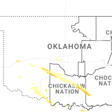
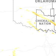
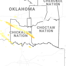
Oklahoma
| Local Time | Report Details |
|---|---|
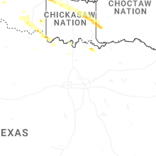
| 2:54 PM CDT | Quarter sized hail reported near Elk City, OK, 71.3 miles S of Woodward, OK |
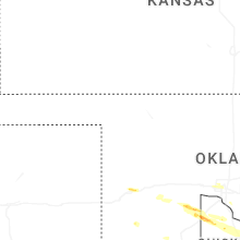
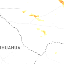
Texas
| Local Time | Report Details |
|---|---|
| 4:14 PM CDT | Quarter sized hail reported near Ropesville, TX, 21.3 miles WSW of Lubbock, TX, report from mping: quarter (1.00 in.). |
| 4:15 PM CDT | Ping Pong Ball sized hail reported near Ropesville, TX, 21.8 miles WSW of Lubbock, TX, measured by the icechip experiment. |
| 4:16 PM CDT | Ping Pong Ball sized hail reported near Ropesville, TX, 21.3 miles WSW of Lubbock, TX, report from mping: ping pong ball (1.50 in.). |
| 4:28 PM CDT | Quarter sized hail reported near Ropesville, TX, 23 miles WSW of Lubbock, TX, reported by nws trained weather spotter. |
| 4:30 PM CDT | Quarter sized hail reported near Levelland, TX, 20.5 miles WSW of Lubbock, TX, estimated largest hail of 1 inch diameter based on impacts. most hail was 1/2 inch diameter. time estimated from radar. |
| 4:54 PM CDT | Tea Cup sized hail reported near Brownfield, TX, 33.1 miles SW of Lubbock, TX, report from mping: baseball+ (3.25 in.). |
| 5:02 PM CDT | Tea Cup sized hail reported near Brownfield, TX, 33.1 miles SW of Lubbock, TX, report from mping: baseball++ (3.50 in.). |
| 5:10 PM CDT | Ping Pong Ball sized hail reported near Brownfield, TX, 37.2 miles SW of Lubbock, TX, picture of half dollar to ping pong ball sized hail in brownfield. relayed by media. exact location is estimated. |
| 5:38 PM CDT | Golf Ball sized hail reported near Brownfield, TX, 42 miles SSW of Lubbock, TX, report from mping: golf ball (1.75 in.). |
| 6:04 PM CDT | Mesonet station 96 welch dawson count in dawson county TX, 48.3 miles SSW of Lubbock, TX |
New Mexico
| Local Time | Report Details |
|---|---|
| 4:31 PM MDT | Mesonet station 51 2sw tatum n in lea county NM, 68.7 miles E of Roswell, NM |
Connect with Interactive Hail Maps