

Hail Map for Friday, May 30, 2025
Number of Impacted Households on 5/30/2025
0
Impacted by 1" or Larger Hail
0
Impacted by 1.75" or Larger Hail
0
Impacted by 2.5" or Larger Hail
Square Miles of Populated Area Impacted on 5/30/2025
0
Impacted by 1" or Larger Hail
0
Impacted by 1.75" or Larger Hail
0
Impacted by 2.5" or Larger Hail
Cities Most Affected by Hail Storms of 5/30/2025
| Hail Size | Demographics of Zip Codes Affected | ||||||
|---|---|---|---|---|---|---|---|
| City | Count | Average | Largest | Pop Density | House Value | Income | Age |
Hail and Wind Damage Spotted on 5/30/2025
Filter by Report Type:Hail ReportsWind Reports
States Impacted
Tennessee, Kentucky, Virginia, Texas, West Virginia, Georgia, South Carolina, Florida, North Carolina, Maryland, Wisconsin, ColoradoTennessee
| Local Time | Report Details |
|---|---|
| 8:36 AM EDT | Wind damage to a travel trailer and structure. first responders are evaluating. possible tornad in loudon county TN, 39 miles WSW of Knoxville, TN |
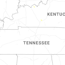
Kentucky
| Local Time | Report Details |
|---|---|
| 9:35 AM EDT | Trees down across roa in greenup county KY, 72.6 miles WNW of Charleston, WV |
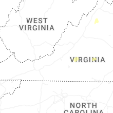
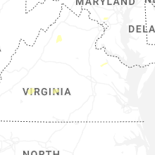
Virginia
| Local Time | Report Details |
|---|---|
| 12:00 PM EDT | Tree down on smokey lane and honey camp road. time estimated from rada in dickenson county VA, 40 miles NNW of Bristol, TN |
| 12:13 PM EDT | Tree down blocking both sides of traffi in dickenson county VA, 38.1 miles NNW of Bristol, TN |
| 12:39 PM EDT | Tree on powerlines down at kennel gap road oakwood... v in buchanan county VA, 44.3 miles NNE of Bristol, TN |
| 12:50 PM EDT | Tree on powerlines down at dismal river road whitewood... v in buchanan county VA, 48.7 miles NNE of Bristol, TN |
| 1:03 PM EDT | Tree and powerlines down at jewell valley roa in buchanan county VA, 51 miles NNE of Bristol, TN |
| 3:03 PM EDT | Multiple trees reported down throughout montgomery count in montgomery county VA, 26.4 miles W of Roanoke, VA |
| 3:20 PM EDT | Tree down on a powerline on pine hollow roa in montgomery county VA, 23.1 miles WSW of Roanoke, VA |
| 3:31 PM EDT | Multiple trees and large limbs down... along with powerlines. a car window was blown out and roof damage occurred to apartment balcony awnings... which were completely in city of salem county VA, 4.9 miles W of Roanoke, VA |
| 3:35 PM EDT | Tree snapped on larkview circl in city of roanoke county VA, 3.4 miles WSW of Roanoke, VA |
| 3:40 PM EDT | Powerlines down on morehead av in city of roanoke county VA, 1.4 miles SE of Roanoke, VA |
| 3:52 PM EDT | Cable line downed and is laying across turner lan in franklin county VA, 11.1 miles S of Roanoke, VA |
| 3:52 PM EDT | One tree down blocking the road on harmony roa in franklin county VA, 11.2 miles S of Roanoke, VA |
| 3:54 PM EDT | One tree down across the roa in franklin county VA, 11.2 miles S of Roanoke, VA |
| 4:04 PM EDT | Tree down on goodview roa in bedford county VA, 11.6 miles ESE of Roanoke, VA |
| 4:05 PM EDT | Tree down across appalachian drive near fieldal in henry county VA, 38.7 miles S of Roanoke, VA |
| 4:11 PM EDT | One tree down across north church driv in franklin county VA, 15.2 miles SE of Roanoke, VA |
| 4:15 PM EDT | One tree down on old franklin turnpik in franklin county VA, 18.3 miles S of Roanoke, VA |
| 4:27 PM EDT | A couple trees down along jackson river roa in highland county VA, 38.2 miles SSE of Elkins, WV |
| 4:32 PM EDT | Tree down on bateman bridge roa in bedford county VA, 37.4 miles E of Roanoke, VA |
| 4:33 PM EDT | Powerlines down on leesville road near the intersection of town fork roa in campbell county VA, 37 miles E of Roanoke, VA |
| 5:15 PM EDT | Trees blew down in mount solo in augusta county VA, 57.4 miles SE of Elkins, WV |
| 5:15 PM EDT | Trees blew down in middlebroo in augusta county VA, 67 miles NE of Roanoke, VA |
| 5:17 PM EDT | A couple of large trees blew down along hundley mill road near staunto in augusta county VA, 63 miles SE of Elkins, WV |
| 5:27 PM EDT | A couple trees down along jackson river roa in highland county VA, 38.2 miles SSE of Elkins, WV |
| 5:30 PM EDT | Trees blew down in weyers cav in augusta county VA, 66.9 miles SE of Elkins, WV |
| 5:30 PM EDT | A new building which was under construction was reported to have collapsed. unsure of the size of this structur in rockingham county VA, 62.1 miles ESE of Elkins, WV |
| 5:32 PM EDT | Trees and wires blew down in the 700 block of madison stree in rockingham county VA, 62.1 miles ESE of Elkins, WV |
| 5:36 PM EDT | Lots of trees reported down... especially near rush lane & indian trail roa in rockingham county VA, 66.7 miles ESE of Elkins, WV |
| 5:45 PM EDT | Trees and wires blew down in the 700 block of maple avenue... and near the intersection of south ellison lane and us-340 rosser avenu in city of waynesboro county VA, 78.4 miles WNW of Richmond, VA |
| 5:45 PM EDT | Corrects previous tstm wnd dmg report from 2 ene tuggle. two trees down on w third st near the intersection with sheppards rd in farmvill in prince edward county VA, 46.3 miles WSW of Richmond, VA |
| 5:52 PM EDT | Large tree limbs blew down on us-211 lee highway about one mile west of us-34 in page county VA, 70 miles ESE of Elkins, WV |
| 6:00 PM EDT | Tree down near intersection of prince edward hwy and rices depot r in prince edward county VA, 38.7 miles WSW of Richmond, VA |
| 6:06 PM EDT | Numerous large trees and branches snapped and uprooted with some falling on cars and trailers along luray mobile homes lan in page county VA, 77 miles ESE of Elkins, WV |
| 6:09 PM EDT | A couple of large trees were uprooted along outpost roa in page county VA, 78.8 miles E of Elkins, WV |
| 6:12 PM EDT | Tree down near intersection of drunkard rd and soap stone rd. time estimated from rada in amelia county VA, 30.3 miles WSW of Richmond, VA |
| 6:15 PM EDT | Tree down blocking west bound lane. time estimated from rada in nottoway county VA, 32.3 miles WSW of Richmond, VA |
| 6:16 PM EDT | Tree down near intersection of amelia springs rd and jetersville rd. time estimated from rada in amelia county VA, 28.7 miles WSW of Richmond, VA |
| 6:22 PM EDT | Tree down around jenkins lane & f.t. valley road in rappahannock county VA, 84.5 miles NNW of Richmond, VA |
| 6:25 PM EDT | Tree down on the 8300 blk of dennisville rd. time estimated from rada in amelia county VA, 22.1 miles WSW of Richmond, VA |
| 6:45 PM EDT | Tree down near intersection of hull st and woodlake village parkway. time estimate in chesterfield county VA, 7.3 miles SSW of Richmond, VA |
| 6:45 PM EDT | Tree down in road on rt. 628 near dorrell road. time estimate in king william county VA, 32 miles NE of Richmond, VA |
| 6:54 PM EDT | Tree down on chalkley rd. time estimated from rada in chesterfield county VA, 13.7 miles SE of Richmond, VA |
| 6:55 PM EDT | Tree down on edenberry dr. time estimate in chesterfield county VA, 2.5 miles ESE of Richmond, VA |
| 7:00 PM EDT | Tree down near intersection of osborne rd and route 1. time estimate in chesterfield county VA, 15.7 miles SE of Richmond, VA |
| 7:15 PM EDT | 2 trees down on tidewater trail near oneal rd and saint matthew church rd. time estimate in essex county VA, 50.4 miles NE of Richmond, VA |
| 8:55 PM EDT | Report of damage to a barn on gwynns island. time estimate in mathews county VA, 52.9 miles NNW of Virginia Beach, VA |
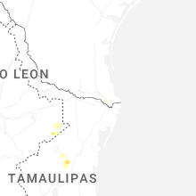
Texas
| Local Time | Report Details |
|---|---|
| 11:26 AM CDT | Galveston county dispatch relayed a report of roof damage to a home around the bayou vista are in galveston county TX, 39 miles SE of Houston, TX |
| 1:15 PM CDT | Public report of small and large trees dow in cameron county TX, 6.3 miles N of Brownsville, TX |
West Virginia
| Local Time | Report Details |
|---|---|
| 1:12 PM EDT | Large tree down on rift berwind roa in mcdowell county WV, 55.6 miles NNE of Bristol, TN |
| 1:16 PM EDT | Tree down across sunbeam road. time estimated from rada in logan county WV, 38.2 miles SSW of Charleston, WV |
| 1:16 PM EDT | Storm knocked some trees down on the power lines and the top of the power pole was on fire. no one has any access on or off the hill at this time. time estimated from r in mcdowell county WV, 57.4 miles NE of Bristol, TN |
| 1:22 PM EDT | Tree down across elkhorn mountain highway in pageton. time estimated from rada in mcdowell county WV, 67.1 miles NE of Bristol, TN |
| 1:22 PM EDT | Tree down in crolitz between iaeger and panther. time estimated from rada in mcdowell county WV, 67.1 miles NE of Bristol, TN |
| 1:30 PM EDT | Tree down on power lines. lines not sparking or smoking at the time. power is out in the area. time estimated from rada in jackson county WV, 28.4 miles N of Charleston, WV |
| 2:04 PM EDT | Trees down blocking turnpike road near beech glen... w in nicholas county WV, 27.3 miles ESE of Charleston, WV |
| 2:10 PM EDT | Trees down between paint creek road and horse creek road at lively... wv. time estimated by rada in fayette county WV, 35 miles SE of Charleston, WV |
| 2:33 PM EDT | Bunch of trees down at hookersville road... hookersville wv. time estimated by rada in nicholas county WV, 44.5 miles E of Charleston, WV |
| 2:40 PM EDT | Trees down at cranberry ridge road. time estimated by rada in webster county WV, 55.4 miles SW of Elkins, WV |
| 2:42 PM EDT | Trees down at centralia road. time estimated by rada in braxton county WV, 47.6 miles WSW of Elkins, WV |
| 2:42 PM EDT | Trees down at state street. time estimated by rada in braxton county WV, 52.2 miles ENE of Charleston, WV |
| 2:42 PM EDT | Tree down blocking road. time estimated based on rada in ritchie county WV, 66.5 miles WNW of Elkins, WV |
| 3:02 PM EDT | Trees down at bergoo road. time estimated by rada in webster county WV, 38.8 miles SW of Elkins, WV |
| 3:10 PM EDT | Numerous large trees down throughout webster county. time matched to rada in webster county WV, 43.2 miles SW of Elkins, WV |
| 3:14 PM EDT | Tree fell on wires. time estimated based on rada in ritchie county WV, 66.1 miles WNW of Elkins, WV |
| 3:31 PM EDT | Photo shows tree down across road. time estimated from rada in upshur county WV, 26.7 miles W of Elkins, WV |
| 3:31 PM EDT | Tree down blocking freemans road in french creek. time estimated from rada in upshur county WV, 27.3 miles W of Elkins, WV |
| 3:31 PM EDT | Tree down blocking old elkins road. time estimated from rada in upshur county WV, 13.8 miles W of Elkins, WV |
| 3:31 PM EDT | Tree down across phillips dairy road. time estimated from rada in upshur county WV, 20.1 miles WNW of Elkins, WV |
| 3:32 PM EDT | Tree down across centerville road. time estimated from rada in upshur county WV, 27.6 miles W of Elkins, WV |
| 3:32 PM EDT | Trees down at woodrow road. time estimated by rada in pocahontas county WV, 47.9 miles SSW of Elkins, WV |
| 3:34 PM EDT | Tree down blocking heavner grove rd. time estimated from rada in upshur county WV, 23.7 miles W of Elkins, WV |
| 3:34 PM EDT | Tree down blocking gould roa in upshur county WV, 23.5 miles W of Elkins, WV |
| 3:36 PM EDT | Tree down on philippi road blocking half the roadway. time estimated from rada in upshur county WV, 21.8 miles WNW of Elkins, WV |
| 3:37 PM EDT | Tree down. time estimated based on rada in ritchie county WV, 63.3 miles WNW of Elkins, WV |
| 3:42 PM EDT | Tree down blocking the northbound lane of clarksburg road. time estimated from rada in upshur county WV, 21.6 miles WNW of Elkins, WV |
| 3:46 PM EDT | Tree damage resulting in 480 customers without powe in doddridge county WV, 56 miles WNW of Elkins, WV |
| 3:46 PM EDT | Tree blocking roadway at teter road and pecks run road. time estimated from rada in upshur county WV, 19.9 miles WNW of Elkins, WV |
| 3:54 PM EDT | Tree fell on house and also sticks out onto switzer drive. tree does not pierce the roof as far as the resident could see. tree is also on power lines but power is stil in barbour county WV, 18.2 miles NW of Elkins, WV |
| 3:55 PM EDT | Trees down along 151 near ellamore. time estimated based on rada in upshur county WV, 13.2 miles W of Elkins, WV |
| 4:07 PM EDT | Tree down with power lines. power is out. time estimated from rada in barbour county WV, 7.3 miles WNW of Elkins, WV |
| 4:12 PM EDT | 5600 webster pike southern taylor county trees and lines down across roadwa in taylor county WV, 28.2 miles NNW of Elkins, WV |
| 4:15 PM EDT | Trees dow in randolph county WV, 1.7 miles SW of Elkins, WV |
| 4:30 PM EDT | Tree down. time estimated based on rada in harrison county WV, 46.8 miles NW of Elkins, WV |
| 4:30 PM EDT | Multiple trees and weather related incidents reported across the county. time estimated based on rada in harrison county WV, 42.1 miles NW of Elkins, WV |
| 4:48 PM EDT | Report of trees down along brushy run road in seneca rocks... w in pendleton county WV, 24.1 miles ESE of Elkins, WV |
| 5:08 PM EDT | Multiple trees down along mary lou retton drive. video provided of possible funnel clou in marion county WV, 40.9 miles NNW of Elkins, WV |
| 5:20 PM EDT | Multiple trees blew down along cr-28/7 jordan run roa in grant county WV, 33.2 miles ENE of Elkins, WV |
| 5:22 PM EDT | Tree has fallen onto the porch - blocking door. hit multiple vehicles. time estimated based on wind obs at kmgw. call came in at 7:30p in monongalia county WV, 52.4 miles S of Pittsburgh, PA |
| 5:30 PM EDT | Trees blew down onto power lines on cr-50/3 bismarck roa in grant county WV, 38.8 miles ENE of Elkins, WV |
| 5:33 PM EDT | Trees blew down along cr-10 rig roa in hardy county WV, 43.4 miles E of Elkins, WV |
| 5:44 PM EDT | Trees blew down along wv-5 in hardy county WV, 48.8 miles ENE of Elkins, WV |
| 6:22 PM EDT | Trees blew down onto wires along cr-7 ford hill roa in hampshire county WV, 69.5 miles ENE of Elkins, WV |
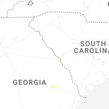
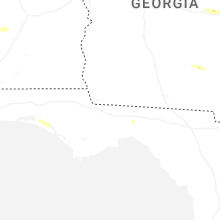
Georgia
| Local Time | Report Details |
|---|---|
| 2:05 PM EDT | Two to three trees down along collier church road near smithonia roa in oglethorpe county GA, 66.2 miles SSW of Greenville, SC |
| 2:39 PM EDT | Multiple trees down in buckhead in morgan count in morgan county GA, 60.7 miles ESE of Atlanta, GA |
| 2:42 PM EDT | Report of multiple downed and snapped trees along with minor structural damage along mccard lake rd between hwy 109 and turner rd. radar showed a strong signal for stra in pike county GA, 49.3 miles S of Atlanta, GA |
| 2:45 PM EDT | Trees down at vega road and highway 1 in pike county GA, 50.4 miles S of Atlanta, GA |
| 3:50 PM EDT | Trained spotter reported a tree fell on the home causing significant damage. time estimated by radar. no injurie in columbia county GA, 7.5 miles WNW of Augusta, GA |
| 4:00 PM EDT | Social media report and photo of tree down on washington rd near tubman rd. time estimated by rada in columbia county GA, 16.1 miles WNW of Augusta, GA |
| 4:49 PM EDT | Mesonet station ga346 i-75 at sr 30 us 28 in crisp county GA, 61.6 miles WNW of Douglas, GA |
| 5:28 PM EDT | Ham radio operator relayed tree down on 5 chop road. time estimated by rada in bulloch county GA, 45 miles NW of Savannah, GA |
| 5:32 PM EDT | Trees down southwest of hadden road and canoe place. location is approximate and time estimated by rada in candler county GA, 66 miles WNW of Savannah, GA |
| 9:04 PM EDT | Ham radio operator relayed tree down on 5 chop road. time estimated by rada in bulloch county GA, 45 miles NW of Savannah, GA |
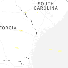
South Carolina
| Local Time | Report Details |
|---|---|
| 3:49 PM EDT | Aiken em reported multiple trees down in the monetta area. time estimated by rada in aiken county SC, 33 miles NE of Augusta, GA |
| 4:07 PM EDT | Quarter sized hail reported near Langley, SC, 7.8 miles ENE of Augusta, GA |
| 4:11 PM EDT | Ping Pong Ball sized hail reported near Graniteville, SC, 7.2 miles ENE of Augusta, GA, public report of 1 to 1.5 inch hail for about 5 minutes. |
| 4:11 PM EDT | Sc highway patrol reported powerlines downed on the roadway on nantuckett rd. time estimated by rada in aiken county SC, 43.3 miles ENE of Augusta, GA |
| 4:16 PM EDT | Sc highway patrol reported several trees down in northeast aiken county northeast of perry and salle in aiken county SC, 44.4 miles ENE of Augusta, GA |
| 4:19 PM EDT | Corrects previous tstm wnd dmg report from 1 se clearwater for correct time. aiken em reported multiple trees and powerlines down across the southern part of the county in aiken county SC, 4.6 miles ENE of Augusta, GA |
| 4:20 PM EDT | Broadcast met reported numerous trees down along know avenue in north august in aiken county SC, 2.3 miles NNE of Augusta, GA |
| 4:22 PM EDT | Ham radio operator reported snapped and downed trees near swansea. time estimated by rada in lexington county SC, 55.8 miles ENE of Augusta, GA |
| 4:24 PM EDT | Ham radio operator reported a tree down on powerlines on cartin rd at culclasure rd. time estimated by rada in lexington county SC, 55.8 miles ENE of Augusta, GA |
| 4:25 PM EDT | Retired nws employee reports large trees down 3 miles ene of swansea. estimates winds as 60 mph or highe in calhoun county SC, 56.2 miles ENE of Augusta, GA |
| 4:29 PM EDT | Orangeburg fire dept reported trees and powerlines down in the roadway on breezehaven rd at north rd. time estimated by rada in orangeburg county SC, 56.4 miles E of Augusta, GA |
| 4:35 PM EDT | Sc highway patrol reported a tree blocking the roadway on i-26 near exit 139. time estimated by rada in calhoun county SC, 58.7 miles WNW of Charleston, SC |
| 4:42 PM EDT | Ham radio operator reported a tree down on a residence on azalea dr. in st. matthews. photo also included. time estimated by rada in calhoun county SC, 54.2 miles NW of Charleston, SC |
| 4:44 PM EDT | Orangeburg fire dept reported trees and powerlines down in the roadway on sunshine ln at waterspring rd. time estimated by rada in orangeburg county SC, 52.6 miles WNW of Charleston, SC |
| 4:46 PM EDT | Orangeburg fire dept reported trees down in the roadway on wille rd and beason rd. time estimated by rada in orangeburg county SC, 57.5 miles E of Augusta, GA |
| 4:51 PM EDT | Sc highway patrol reported a tree down on the roadway on old edisto dr. west of orangeburg. time estimated by rada in orangeburg county SC, 54.4 miles WNW of Charleston, SC |
| 4:57 PM EDT | Sc highway patrol reported a tree down in the roadway on pinewood rd at stadium rd. time estimated by rada in sumter county SC, 52.3 miles NNW of Charleston, SC |
| 5:05 PM EDT | Sc highway patrol reported a tree blocking the roadway on i-95 southbound. time estimated by rada in clarendon county SC, 44.9 miles N of Charleston, SC |
| 5:13 PM EDT | Clarendon dispatch reported a tree downed blocking the roadway on south cantey st. in summerton. time estimated by rada in clarendon county SC, 34.5 miles NW of Charleston, SC |
| 5:15 PM EDT | Spotter reported trees down on his property. time estimated by rada in clarendon county SC, 33.3 miles NNW of Charleston, SC |
| 5:16 PM EDT | Clarendon dispatch reported trees and powerlines down on the road on bill davis rd. time estimated by rada in clarendon county SC, 30.9 miles NNW of Charleston, SC |
| 5:17 PM EDT | Clarendon em reported a tree down on a home on lake shore dr. time estimated by rada in clarendon county SC, 28.2 miles NNW of Charleston, SC |
| 5:17 PM EDT | Clarendon em reported several trees down in and around the summerton area. time estimated by rada in clarendon county SC, 31.5 miles NNW of Charleston, SC |
| 5:19 PM EDT | Aiken em reported multiple trees and powerlines down across the southern part of the county in the north augusta... belvedere... and clearwater areas. time estimated by in aiken county SC, 4.6 miles ENE of Augusta, GA |
| 5:20 PM EDT | Public reported trees down. time estimated by rada in clarendon county SC, 26.1 miles NNW of Charleston, SC |
| 5:24 PM EDT | Clarendon em reported several trees down in and around the manning area. time estimated by rada in clarendon county SC, 34.1 miles N of Charleston, SC |
| 5:25 PM EDT | Sc highway patrol reported trees down along ashleigh road north of barnwel in barnwell county SC, 39.6 miles ESE of Augusta, GA |
| 5:32 PM EDT | Emergency manager reported a tree down at 3457 highway 4 in berkeley county SC, 17.2 miles NNW of Charleston, SC |
| 5:54 PM EDT | Emergency manager reported tree down at santee river rd and everette lan in berkeley county SC, 15.8 miles NE of Charleston, SC |
| 5:54 PM EDT | Emergency manager reported tree down on hood street in st. stephe in berkeley county SC, 15 miles NNE of Charleston, SC |
| 5:55 PM EDT | Numerous trees down on wild turkey road near stucke in williamsburg county SC, 46.6 miles NE of Charleston, SC |
| 5:58 PM EDT | Numerous trees down around the stuckey area. time estimated via rada in williamsburg county SC, 44.9 miles NE of Charleston, SC |
| 6:00 PM EDT | Emergency management reported numerous trees down near the hemingway area. exact area has not yet been confirmed... time estimated via rada in williamsburg county SC, 50.1 miles NE of Charleston, SC |
| 6:05 PM EDT | Sc forestry commission reports damage to brick sign and minor roof damage at old johnsonville methodist church on hwy 41. time estimated via rada in florence county SC, 52.6 miles NE of Charleston, SC |
| 6:20 PM EDT | Tree down on roadway on n magnolia ave in andrew in georgetown county SC, 31.5 miles NE of Charleston, SC |
| 6:30 PM EDT | Tree down on chamberlin rd in cypress river plantatio in horry county SC, 63.6 miles ENE of Charleston, SC |
| 6:30 PM EDT | Multiple trees down/snapped in the walden preserve and heritage preserve complexes off of hwy 90. time estimated via rada in horry county SC, 60.9 miles WSW of Wilmington, NC |
| 6:30 PM EDT | Two trees down on a garage complex on st ives roa in horry county SC, 68.3 miles ENE of Charleston, SC |
| 6:35 PM EDT | Tree down on old altman rd in conway... off of highway 90... knocking out power to local resident in horry county SC, 63.8 miles WSW of Wilmington, NC |
| 6:35 PM EDT | Storm damage reported in horry county SC, 67.9 miles WSW of Wilmington, NC |
| 6:48 PM EDT | Storm damage reported in horry county SC, 53.2 miles WSW of Wilmington, NC |
Florida
| Local Time | Report Details |
|---|---|
| 3:50 PM EDT | The asos at the orlando international airport measured a wind gust of 63mph/55kts from the south-southwes in orange county FL, 8.5 miles SSE of Orlando, FL |
| 5:36 PM EDT | Fallen trees or limbs resulted in a power outage near i-10 and waukeenah highwa in jefferson county FL, 21.6 miles E of Tallahassee, FL |
| 5:43 PM EDT | Tree down on little cat roa in madison county FL, 50.3 miles E of Tallahassee, FL |
| 6:10 PM EDT | Corrects previous tstm wnd dmg report from 5 se lee. fhp website reported a tree blocking the exit at i-10 rest area mile marker 26 in madison county FL, 61.7 miles E of Tallahassee, FL |
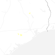
North Carolina
| Local Time | Report Details |
|---|---|
| 4:08 PM EDT | Powerlines down across drivewa in chatham county NC, 34.7 miles WSW of Raleigh, NC |
| 4:13 PM EDT | Tree down at peachland-polkton rd and freedom rd. time estimated based on rada in anson county NC, 38.2 miles ESE of Charlotte, NC |
| 4:25 PM EDT | Tree down on powerlines near deep creek roa in anson county NC, 45.4 miles ESE of Charlotte, NC |
| 6:16 PM EDT | Delayed report. beaufort county 911 center reported a tree down near the intersection of asbury church road and magnolia school road. time estimated based on rada in beaufort county NC, 94.6 miles E of Raleigh, NC |
| 7:08 PM EDT | Storm damage reported in amz252 county NC, 41 miles SW of Wilmington, NC |
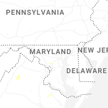
Maryland
| Local Time | Report Details |
|---|---|
| 5:18 PM EDT | Multiple trees reported down across the city of oaklan in garrett county MD, 40.8 miles NE of Elkins, WV |
| 5:45 PM EDT | Multiple trees down across the city of mchenry in garrett county MD, 50.7 miles NNE of Elkins, WV |
| 7:00 PM EDT | Tree down along oldtown road in far eastern allegany c in allegany county MD, 76.7 miles NE of Elkins, WV |
| 7:12 PM EDT | Report of a tree down along briggs chaney roa in montgomery county MD, 23.4 miles SW of Baltimore, MD |
| 8:25 PM EDT | Several trees and wires blew down in the northern part of hagerstow in washington county MD, 64.6 miles WNW of Baltimore, MD |
| 8:48 PM EDT | Trees blew down onto eastbound i-495 capital beltway inner loop between exit 29/md-193 university boulevard and exit 28/md-650 new hampshire avenue... blocking all but in montgomery county MD, 27.7 miles SW of Baltimore, MD |
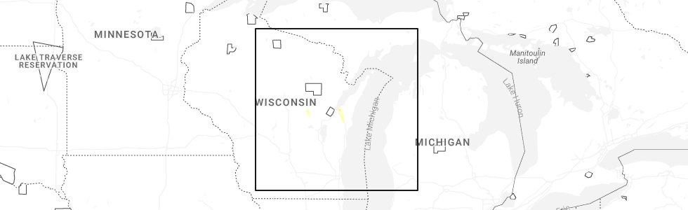
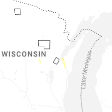
Wisconsin
| Local Time | Report Details |
|---|---|
| 5:05 PM CDT | Quarter sized hail reported near Green Bay, WI, 3.7 miles ENE of Green Bay, WI |
| 5:21 PM CDT | Quarter sized hail reported near Manawa, WI, 43.6 miles W of Green Bay, WI |
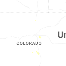
Colorado
| Local Time | Report Details |
|---|---|
| 5:45 PM MDT | Quarter sized hail reported near Cripple Creek, CO, 45.2 miles NW of Pueblo, CO, report from mping: quarter (1.00 in.). |
Connect with Interactive Hail Maps