

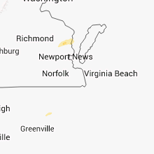
Hail Map for Friday, April 12, 2013

Number of Impacted Households on 4/12/2013
0
Impacted by 1" or Larger Hail
0
Impacted by 1.75" or Larger Hail
0
Impacted by 2.5" or Larger Hail
Square Miles of Populated Area Impacted on 4/12/2013
0
Impacted by 1" or Larger Hail
0
Impacted by 1.75" or Larger Hail
0
Impacted by 2.5" or Larger Hail
Cities Most Affected by Hail Storms of 4/12/2013
| Hail Size | Demographics of Zip Codes Affected | ||||||
|---|---|---|---|---|---|---|---|
| City | Count | Average | Largest | Pop Density | House Value | Income | Age |
Hail and Wind Damage Spotted on 4/12/2013
Filter by Report Type:Hail ReportsWind Reports
Maryland
| Local Time | Report Details |
|---|---|
| 2:40 PM EDT | Storm damage reported in anz533 county MD, 51.5 miles SSE of Baltimore, MD |
| 5:50 PM EDT | Storm damage reported in anz537 county MD, 71.5 miles WSW of Ocean City, MD |
South Carolina
| Local Time | Report Details |
|---|---|
| 3:05 PM EDT | Tree in the roadway at east jacksonboro road and sc highway 6 in colleton county SC, 38.9 miles SW of Charleston, SC |
| 3:31 PM EDT | Tree down on a powerline along highway 261 near the stuckey airpor in williamsburg county SC, 46.5 miles NE of Charleston, SC |
Colorado
| Local Time | Report Details |
|---|---|
| 2:14 PM MDT | Storm damage reported in washington county CO, 25.9 miles W of Yuma, CO |
North Carolina
| Local Time | Report Details |
|---|---|
| 6:05 PM EDT | Report of four cedar trees blown down with tops broken off. shingles and gutters blown off storage she in craven county NC, 82.2 miles NNE of Wilmington, NC |
Virginia
| Local Time | Report Details |
|---|---|
| 9:30 PM EDT | Trees down on lewis b puller hwy in gloucester county VA, 56.2 miles E of Richmond, VA |
| 9:34 PM EDT | Trees down in gloucester county VA, 56.2 miles E of Richmond, VA |
Connect with Interactive Hail Maps