

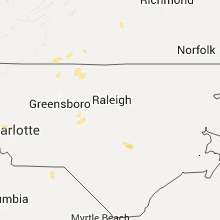
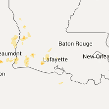
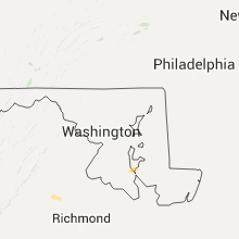
Hail Map for Tuesday, August 11, 2015

Number of Impacted Households on 8/11/2015
0
Impacted by 1" or Larger Hail
0
Impacted by 1.75" or Larger Hail
0
Impacted by 2.5" or Larger Hail
Square Miles of Populated Area Impacted on 8/11/2015
0
Impacted by 1" or Larger Hail
0
Impacted by 1.75" or Larger Hail
0
Impacted by 2.5" or Larger Hail


Cities Most Affected by Hail Storms of 8/11/2015
| Hail Size | Demographics of Zip Codes Affected | ||||||
|---|---|---|---|---|---|---|---|
| City | Count | Average | Largest | Pop Density | House Value | Income | Age |
Hail and Wind Damage Spotted on 8/11/2015
Filter by Report Type:Hail ReportsWind Reports
States Impacted
Arizona, Georgia, Virginia, North Carolina, Louisiana, Texas, Colorado, Utah, South Carolina, Idaho, Florida, AlabamaArizona
| Local Time | Report Details |
|---|---|
| 9:31 AM MST | Storm damage reported in maricopa county AZ, 20 miles E of Phoenix, AZ |
| 10:00 AM MST | A 12 in. diameter tree blown over near intersection of viewpoint and horseshoe in prescott valley. numerous branches down from other nearby tree in yavapai county AZ, 52.6 miles SW of Flagstaff, AZ |
| 10:00 AM MST | Palo verde tree with 8-10 inch diameter trunk knocked down onto car near 44th st and van bure in maricopa county AZ, 5 miles E of Phoenix, AZ |
| 10:03 AM MST | Storm damage reported in maricopa county AZ, 16.7 miles N of Phoenix, AZ |
| 10:15 AM MST | 8 inch diameter tree limb downed in maricopa county AZ, 12.2 miles SE of Phoenix, AZ |
| 10:15 AM MST | At least two palo verde trees with trunk diameters of six to twelve inches knocked down or severely damaged near 83rd ave and mcdowell r in maricopa county AZ, 9.6 miles W of Phoenix, AZ |
| 12:04 PM MST | High wind blew through central portion of city... trees down... power lines down... lots of lightning in yavapai county AZ, 38.5 miles SSW of Flagstaff, AZ |
| 6:00 PM MST | A significant amount of power poles down on rt70 between soloman... safford and thatcher az. street flooding along many secondary roads and route 7 in graham county AZ, 83 miles W of Silver City, NM |
| 7:30 PM MST | Two trees down at oro valley market place shopping cente in pima county AZ, 13.7 miles N of Tucson, AZ |
| 8:45 PM MST | Storm damage reported in pinal county AZ, 41.3 miles SSE of Phoenix, AZ |
| 8:50 PM MST | 11400 srp customers without power in portions of the southeast valley. worst areas affected appear to be in the san tan valle in pinal county AZ, 35 miles ESE of Phoenix, AZ |
| 8:55 PM MST | Seven downed trees in neighborhood with trunk diameters ranging from six inches to two feet near power road and germann rd. railroad crossing arm damaged at power and p in maricopa county AZ, 25.5 miles ESE of Phoenix, AZ |
| 8:55 PM MST | 0.75 mile visibility in blowing dust in pinal county AZ, 38.6 miles SSE of Phoenix, AZ |
| 9:04 PM MST | At least two small aircraft overturned at chandler municipal airport. air stairs blown ove in maricopa county AZ, 19.2 miles SE of Phoenix, AZ |
| 9:06 PM MST | Palm tree uprooted near rittenhouse road and ocotillo road. visibilitiy down to one quarter mile in blowing dus in maricopa county AZ, 31.4 miles ESE of Phoenix, AZ |
| 9:19 PM MST | At 0920 pm a peak wind gust of 62 mph was measured at mesa-gateway airport -kiw in maricopa county AZ, 25.9 miles ESE of Phoenix, AZ |
| 9:23 PM MST | Downed power lines over road at florence junction. us-60 closed at mp 21 in pinal county AZ, 44.5 miles ESE of Phoenix, AZ |
| 9:38 PM MST | 1 foot diameter tree down near chandler heights and higley in maricopa county AZ, 25.1 miles SE of Phoenix, AZ |
Georgia
| Local Time | Report Details |
|---|---|
| 1:45 PM EDT | Microburst downed 13 trees and blew down a shed. minor damage to a few homes along old anderson cemetary roa in tattnall county GA, 54 miles WSW of Savannah, GA |
Virginia
| Local Time | Report Details |
|---|---|
| 1:52 PM EDT | One tree down on green ridge road in roanoke county VA, 6 miles NW of Roanoke, VA |
| 2:06 PM EDT | One tree down at the intersection of franklin road and wonju street in city of roanoke county VA, 1.8 miles SW of Roanoke, VA |
| 2:08 PM EDT | One tree down at the intersection of prospect road and j p fishburn parkway in city of roanoke county VA, 2.2 miles S of Roanoke, VA |
| 2:27 PM EDT | One tree down on quarterwood road in bedford county VA, 14.1 miles ENE of Roanoke, VA |
| 3:24 PM EDT | One tree down blocking lambs church road in campbell county VA, 42.2 miles ESE of Roanoke, VA |
| 3:24 PM EDT | One tree down blocking both lanes of red house road near the intersection with rhonda road in campbell county VA, 50.4 miles E of Roanoke, VA |
| 3:34 PM EDT | One tree down on oak level road in henry county VA, 34.6 miles S of Roanoke, VA |
| 3:34 PM EDT | One tree down on reed creek drive in henry county VA, 34.6 miles S of Roanoke, VA |
| 3:37 PM EDT | One tree down on figsboro road in henry county VA, 36.1 miles S of Roanoke, VA |
| 3:44 PM EDT | One tree down on ridgecrest avenue in henry county VA, 38.1 miles S of Roanoke, VA |
| 4:05 PM EDT | Numerous trees down from south of farmville to hampden sydney along highway 1 in prince edward county VA, 46.3 miles WSW of Richmond, VA |
| 4:15 PM EDT | Numerous trees down east of louisa mainly north of highway 22. several roads blocked and power lines pulled dow in louisa county VA, 39.4 miles NNW of Richmond, VA |
| 4:38 PM EDT | Trees down around prospec in prince edward county VA, 51.9 miles WSW of Richmond, VA |
| 4:50 PM EDT | Trees down along jericho roa in caroline county VA, 32 miles N of Richmond, VA |
| 5:00 PM EDT | Four large tree limbs dow in henry county VA, 50 miles S of Roanoke, VA |
| 5:15 PM EDT | Tree down along highway 360 near millers taver in king and queen county VA, 36.6 miles ENE of Richmond, VA |
| 5:50 PM EDT | Several trees down in the church view area blocking road in middlesex county VA, 54.7 miles ENE of Richmond, VA |
North Carolina
| Local Time | Report Details |
|---|---|
| 2:41 PM EDT | Multiple trees down north of ruffin. reported by wgh in rockingham county NC, 57.7 miles SSE of Roanoke, VA |
| 3:25 PM EDT | Several trees blown down. time estimated from radar downburst signatur in lincoln county NC, 26.2 miles NW of Charlotte, NC |
| 5:15 PM EDT | Reported one tree down and multiple branches down described as thick as an arm. time radar estimate in caswell county NC, 53.2 miles NW of Raleigh, NC |
| 5:20 PM EDT | One tree down on stoney creek school road in caswell county NC, 57.9 miles NW of Raleigh, NC |
| 5:30 PM EDT | Four pine trees dow in caswell county NC, 54.2 miles NW of Raleigh, NC |
| 5:33 PM EDT | Tree down at gordonton road... time estimated by radar in person county NC, 44.2 miles NW of Raleigh, NC |
| 5:33 PM EDT | Power lines down at hurdle mills road... time estimated by radar in person county NC, 40.5 miles NW of Raleigh, NC |
| 5:33 PM EDT | Tree down at mccullock loop road... time estimated by radar in person county NC, 41 miles NW of Raleigh, NC |
| 5:36 PM EDT | Tree down at union grove church road... time estimated by radar in person county NC, 40.8 miles NW of Raleigh, NC |
| 7:41 PM EDT | Trees down in the roadwa in johnston county NC, 17.7 miles ESE of Raleigh, NC |
| 8:10 PM EDT | Trees down across roadwa in johnston county NC, 26.5 miles SE of Raleigh, NC |
| 9:23 PM EDT | Trees down at kitty fork and mt moriah church road... time estimated by radar in sampson county NC, 52 miles SSE of Raleigh, NC |
| 9:26 PM EDT | Tree and powerlines down on topeka drive. tree in roadway on beaver dam lane and old oak stree in mecklenburg county NC, 10.5 miles ESE of Charlotte, NC |
Louisiana
| Local Time | Report Details |
|---|---|
| 1:55 PM CDT | Acadia sheriff relayed a public report of wind damage in the 3000 block of white oak hwy. the report indicated downed power lines and a camper knocked off its block in acadia county LA, 17.6 miles WNW of Lafayette, LA |
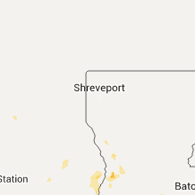
Texas
| Local Time | Report Details |
|---|---|
| 3:28 PM CDT | Trees downed behind weingarten shopping center in south tyle in smith county TX, 76.2 miles NNW of Lufkin, TX |
| 3:30 PM CDT | Multiple trees down and power outages between whitehouse and bullard in smith county TX, 67.7 miles NNW of Lufkin, TX |
| 3:40 PM CDT | Multiple trees down 1 mile nw of flint in smith county TX, 70.1 miles NNW of Lufkin, TX |
| 4:05 PM CDT | 5 general aviation aircraft were picked up and thrown approx 150 yards at hawthorne field in kountze... tx. all five aircraft were described as totalle in hardin county TX, 39.8 miles WNW of Beaumont, TX |
| 4:24 PM CDT | Trees blown down... one on a truck in montgomery county TX, 47.8 miles NNW of Houston, TX |
| 4:54 PM CDT | Thunderstorm wind gust was measured at dwh asos sit in harris county TX, 22.3 miles NW of Houston, TX |
| 6:00 PM CDT | Freeway sign wind damage at scott street and loop 610 in harris county TX, 1.4 miles WNW of Houston, TX |
| 6:00 PM CDT | 3 trees down near highway 21 and brazos river. kbtx media retwee in burleson county TX, 79.9 miles ESE of Killeen, TX |
| 6:24 PM CDT | Quarter sized hail reported near Sugar Land, TX, 18.2 miles WSW of Houston, TX |
| 6:31 PM CDT | Wind gust was measured at sugar land asos site ksg in fort bend county TX, 17.9 miles WSW of Houston, TX |
| 6:42 PM CDT | Large tree was downed in a backyard near the intersection of monroe road and interstate 4 in harris county TX, 9.1 miles SE of Houston, TX |
| 6:45 PM CDT | Quarter sized hail reported near Richmond, TX, 27.1 miles WSW of Houston, TX, quarter size hail in richmond. |
Colorado
| Local Time | Report Details |
|---|---|
| 3:32 PM MDT | Quarter sized hail reported near Cotopaxi, CO, 49.9 miles W of Pueblo, CO |
Utah
| Local Time | Report Details |
|---|---|
| 3:35 PM MDT | Upper cedar mountain sensor dpg16 in tooele county UT, 64.4 miles WSW of Salt Lake City, UT |
South Carolina
| Local Time | Report Details |
|---|---|
| 5:55 PM EDT | Tree down across roadway at the intersection of janette dr adn coffin point rd. time estimated from radar in beaufort county SC, 43.1 miles NE of Savannah, GA |
| 6:20 PM EDT | Several trees and powerlines reported down by ham radio networ in oconee county SC, 18.2 miles W of Greenville, SC |
| 6:35 PM EDT | Trees down on hunts mill road. time estmd by rada in chesterfield county SC, 59.7 miles SE of Charlotte, NC |
| 6:40 PM EDT | Tree damage/trees down tec road and west market street extensio in chesterfield county SC, 63.6 miles SE of Charlotte, NC |
| 6:47 PM EDT | Tree down bloomville rd at bonanza crossing. time estimated by rada in clarendon county SC, 31.1 miles NNW of Charleston, SC |
| 6:58 PM EDT | Several trees and powerlines blown down on west cherry roa in oconee county SC, 19.3 miles SW of Greenville, SC |
Idaho
| Local Time | Report Details |
|---|---|
| 4:30 PM MDT | Itd22 near jackpot reported a thunderstorm wind gust of 50 mp in twin falls county ID, 38.4 miles SSW of Twin Falls, ID |
| 4:45 PM MDT | Glenns ferry agrimet reported a thunderstorm wind gust of 50 mp in elmore county ID, 50.2 miles WNW of Twin Falls, ID |
| 4:45 PM MDT | Public reported a thunderstorm wind gust of 52 mp in boise county ID, 20.9 miles N of Boise, ID |
| 4:45 PM MDT | Trail gulch raws reported a thunderstorm wind gust of 55 mp in twin falls county ID, 18.6 miles SSE of Twin Falls, ID |
| 4:52 PM MDT | Horse butte raws reported a thunderstorm wind gust of 48 mp in owyhee county ID, 39.9 miles WSW of Twin Falls, ID |
| 5:05 PM MDT | Twin buttes raws reported a thunderstorm wind gust of 63 mp in owyhee county ID, 62.3 miles W of Twin Falls, ID |
| 5:13 PM MDT | Kmuo reported a thunderstorm wind gust of 51 mp in elmore county ID, 41.8 miles SSE of Boise, ID |
| 5:15 PM MDT | Mountain home awos ku76 reported a thunderstorm wind gust of 54 mp in elmore county ID, 41 miles SE of Boise, ID |
| 6:00 PM MDT | Branch the diameter of a jeep inner hubcap /8-10 inches/ felled on jeep near 9th street and franklin st in ada county ID, 2.1 miles WNW of Boise, ID |
| 6:10 PM MDT | Tree damage at franklin park near bishop kelly h.s. time estimated from rada in ada county ID, 5.9 miles W of Boise, ID |
| 6:29 PM MDT | Kboi reported a thunderstorm wind gust of 47 mp in ada county ID, 1.9 miles W of Boise, ID |
| 6:34 PM MDT | Idaho power reported multiple outages in boise and throught the treasure valle in ada county ID, 1.9 miles W of Boise, ID |
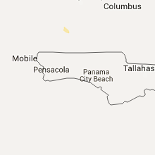
Florida
| Local Time | Report Details |
|---|---|
| 7:07 PM EDT | Tree blown down along the side of tram road near the intersection with capital circle not impacting the road in leon county FL, 5.1 miles SE of Tallahassee, FL |
Alabama
| Local Time | Report Details |
|---|---|
| 6:23 PM CDT | Tree down on southbound lane of i-65 at mile marker 11 in butler county AL, 36.3 miles ESE of Camden, AL |
Connect with Interactive Hail Maps