

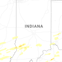
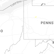
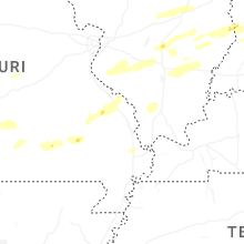
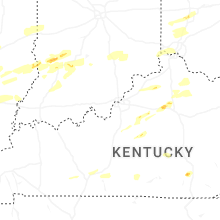
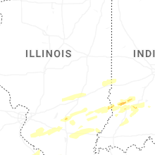
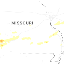
Hail Map for Tuesday, April 29, 2025

Number of Impacted Households on 4/29/2025
0
Impacted by 1" or Larger Hail
0
Impacted by 1.75" or Larger Hail
0
Impacted by 2.5" or Larger Hail
Square Miles of Populated Area Impacted on 4/29/2025
0
Impacted by 1" or Larger Hail
0
Impacted by 1.75" or Larger Hail
0
Impacted by 2.5" or Larger Hail


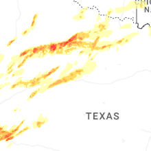

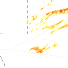

Cities Most Affected by Hail Storms of 4/29/2025
| Hail Size | Demographics of Zip Codes Affected | ||||||
|---|---|---|---|---|---|---|---|
| City | Count | Average | Largest | Pop Density | House Value | Income | Age |
| Guthrie, TX | 3 | 4.83 | 5.00 | 0 | $14k | $41.5k | 43.6 |
| Post, TX | 3 | 2.67 | 3.50 | 5 | $39k | $26.8k | 33.1 |
| Girard, TX | 1 | 4.00 | 4.00 | 1 | $41k | $21.9k | 51.0 |
| Floydada, TX | 2 | 1.88 | 2.00 | 7 | $35k | $25.8k | 38.1 |
| Seymour, TX | 1 | 2.50 | 2.50 | 4 | $34k | $24.5k | 47.1 |
| Lubbock, TX | 1 | 2.00 | 2.00 | 267 | $35k | $21.1k | 26.4 |
| Olney, TX | 1 | 2.00 | 2.00 | 15 | $34k | $25.4k | 42.7 |
| Hermleigh, TX | 1 | 1.75 | 1.75 | 5 | $35k | $29.9k | 46.3 |
| Big Spring, TX | 1 | 1.75 | 1.75 | 32 | $39k | $30.5k | 38.4 |
| Knox City, TX | 1 | 1.75 | 1.75 | 8 | $29k | $25.9k | 42.0 |
| Tahoka, TX | 1 | 1.75 | 1.75 | 2 | $42k | $25.9k | 39.2 |
| Wolfforth, TX | 1 | 1.75 | 1.75 | 120 | $62k | $36.7k | 35.3 |
| Webb City, MO | 1 | 1.75 | 1.75 | 441 | $72k | $30.4k | 32.4 |
| Iraan, TX | 1 | 1.75 | 1.75 | 0 | $42k | $46.3k | 37.4 |
| Warsaw, NY | 1 | 1.75 | 1.75 | 81 | $68k | $38.1k | 42.3 |
Hail and Wind Damage Spotted on 4/29/2025
Filter by Report Type:Hail ReportsWind Reports
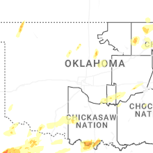
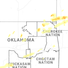
States Impacted
Oklahoma, Kansas, Illinois, Missouri, Arkansas, Indiana, Ohio, Texas, Michigan, New York, Pennsylvania, West Virginia, Kentucky, Mississippi, New MexicoOklahoma
| Local Time | Report Details |
|---|---|
| 7:01 AM CDT | Quarter sized hail reported near Skiatook, OK, 21.7 miles N of Tulsa, OK, report from mping: quarter (1.00 in.). |
| 7:05 AM CDT | Roof and tree damage reports via social media. time and location estimated by rada in tulsa county OK, 15.1 miles NNE of Tulsa, OK |
| 7:15 AM CDT | Multiple large tree limbs down just east of the rogers and tulsa county lines off 76th street nort in rogers county OK, 14.5 miles NE of Tulsa, OK |
| 7:15 AM CDT | Large tree limbs down near e 76th st n and n 177th e av in rogers county OK, 15 miles NE of Tulsa, OK |
| 7:15 AM CDT | Damage to power pole just north of cromwell. time estimated by rada in seminole county OK, 60.4 miles E of Oklahoma City, OK |
| 7:15 AM CDT | A tree was down across e 106th st n... near n 181st east av in rogers county OK, 16.7 miles NE of Tulsa, OK |
| 7:28 AM CDT | Storm damage reported in rogers county OK, 23.4 miles NE of Tulsa, OK |
| 7:31 AM CDT | Quarter sized hail reported near Claremore, OK, 24.6 miles ENE of Tulsa, OK |
| 7:47 AM CDT | Storm damage reported in mayes county OK, 36.6 miles E of Tulsa, OK |
| 7:55 AM CDT | Mesonet station miam miam in ottawa county OK, 64.2 miles SSE of Chanute, KS |
| 7:58 AM CDT | Power poles and trees down in miam in ottawa county OK, 64.3 miles SSE of Chanute, KS |
| 8:29 AM CDT | Half Dollar sized hail reported near Noble, OK, 23.1 miles SSE of Oklahoma City, OK |
| 8:30 AM CDT | Thunderstorm wind damage reported at delaware county fairgrounds and near highway 59 & e390 road in ja in delaware county OK, 70.8 miles ENE of Tulsa, OK |
| 12:42 AM CDT | Quarter sized hail reported near Frederick, OK, 34.8 miles NW of Wichita Falls, TX |
| 1:10 AM CDT | Storm damage reported in cherokee county OK, 50.8 miles NW of Fort Smith, AR |
| 2:25 AM CDT | Storm damage reported in cotton county OK, 34.8 miles NNE of Wichita Falls, TX |
| 2:30 AM CDT | Storm damage reported in cotton county OK, 34.8 miles NNE of Wichita Falls, TX |
| 2:52 AM CDT | Personal weather station measuremen in cotton county OK, 34.8 miles NNE of Wichita Falls, TX |
| 3:05 AM CDT | Large tree (3 or 4 foot diameter) tree fell onto hous in stephens county OK, 44.4 miles NE of Wichita Falls, TX |
| 3:12 AM CDT | Power lines down on highway 53 approximately 3 mile west of comanche lake. time estimate in stephens county OK, 46.9 miles NE of Wichita Falls, TX |
| 5:51 AM CDT | Trained spotter recorded 55 to 60 mph wind gust in tillman county OK, 49.7 miles NNW of Wichita Falls, TX |
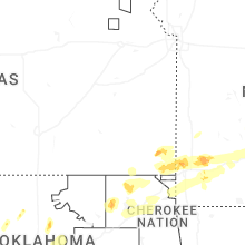
Kansas
| Local Time | Report Details |
|---|---|
| 7:21 AM CDT | Quarter sized hail reported near Cherokee, KS, 41.7 miles ESE of Chanute, KS, 1 inch hail just north of cherokee. |
| 7:30 AM CDT | Picture of a tree on a house. time based on radar estimat in crawford county KS, 45.3 miles ESE of Chanute, KS |
| 8:10 AM CDT | Quarter sized hail reported near Galena, KS, 61 miles SE of Chanute, KS, 1 inch hail in galena ks. |
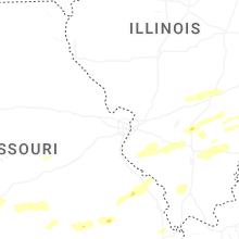
Illinois
| Local Time | Report Details |
|---|---|
| 7:48 AM CDT | Damage to 2 grain silos and a handful of other farm building in washington county IL, 49.6 miles E of Saint Louis, MO |
| 8:00 AM CDT | Several large tree limbs snapped. facebook report. time estimated from rada in marion county IL, 58.4 miles E of Saint Louis, MO |
| 8:12 AM CDT | Storm damage reported in marion county IL, 66.3 miles SSW of Mattoon, IL |
| 12:02 PM CDT | Numerous branches dow in washington county IL, 50.6 miles ESE of Saint Louis, MO |
| 1:43 PM CDT | Utility pole down in coulterville. time estimated from rada in randolph county IL, 44 miles SE of Saint Louis, MO |
| 2:00 PM CDT | Half Dollar sized hail reported near Richview, IL, 52.6 miles ESE of Saint Louis, MO |
| 2:15 PM CDT | Tree down across the road in the royalton are in franklin county IL, 46.4 miles NNE of Cape Girardeau, MO |
| 2:25 PM CDT | Tree down blocking exit ramp of i-57 at benton... i in franklin county IL, 58.4 miles NE of Cape Girardeau, MO |
| 2:25 PM CDT | Multiple trees and power lines down throughout franklin county... from state highway 184/149 to rend lake are in franklin county IL, 47.3 miles NNE of Cape Girardeau, MO |
| 2:30 PM CDT | Power lines down across route 37 near ewing roa in franklin county IL, 64.5 miles NNE of Cape Girardeau, MO |
| 2:40 PM CDT | Barn collapsed in ewing are in franklin county IL, 66.3 miles NE of Cape Girardeau, MO |
| 3:15 PM CDT | Two large trees down across hwy 45 just south of fairfiel in wayne county IL, 50.4 miles WNW of Evansville, IN |
| 3:45 PM CDT | Large tree blocking route 1 in 1000 block of cherry stree in wabash county IL, 32.4 miles NNW of Evansville, IN |
| 3:47 PM CDT | Multiple trees down. damage to some buildings due to tree in wabash county IL, 32.6 miles NNW of Evansville, IN |
Missouri
| Local Time | Report Details |
|---|---|
| 8:14 AM CDT | Seeing some rotation of cloud in jasper county MO, 66.4 miles SE of Chanute, KS |
| 8:15 AM CDT | Quarter sized hail reported near Joplin, MO, 66.5 miles SE of Chanute, KS |
| 8:20 AM CDT | Ping Pong Ball sized hail reported near Joplin, MO, 65.3 miles W of Springfield, MO, 1.65 inch hail. |
| 8:22 AM CDT | Quarter sized hail reported near Webb City, MO, 64.8 miles SE of Chanute, KS, hail at webb city... been going on about 3 minutes. |
| 8:24 AM CDT | Large tree dow in jasper county MO, 66.1 miles W of Springfield, MO |
| 8:25 AM CDT | Quarter sized hail reported near Webb City, MO, 64 miles W of Springfield, MO, report from mping... quarter 1.00 in. |
| 8:27 AM CDT | Possible tornado damage at the 23 mm i 49 southbound south of neosho in newton county. part of a barn is blocking the interstate with multiple trees down in a defined p in newton county MO, 67.6 miles WSW of Springfield, MO |
| 8:29 AM CDT | Quarter sized hail reported near Webb City, MO, 63.4 miles W of Springfield, MO, report from mping quarter 1.00 in. |
| 8:33 AM CDT | Quarter sized hail reported near Webb City, MO, 64.8 miles SE of Chanute, KS |
| 8:35 AM CDT | I went outside after the storm that passed came through and my i had 2-3 trees snapped in half and they were thick beautiful trees. possible tornad in newton county MO, 57.8 miles WSW of Springfield, MO |
| 8:36 AM CDT | Heavy rain and strong wind est 50-60 mph ne of neosh in newton county MO, 63.3 miles WSW of Springfield, MO |
| 8:36 AM CDT | Golf Ball sized hail reported near Webb City, MO, 64.5 miles W of Springfield, MO, report from mping golf ball 1.75 in. |
| 8:37 AM CDT | Quarter sized hail reported near Webb City, MO, 63.4 miles W of Springfield, MO, report from mping quarter 1.00 in. |
| 8:50 AM CDT | Tree and power lines dow in barry county MO, 41.1 miles WSW of Springfield, MO |
| 8:50 AM CDT | Lots of trees dow in barry county MO, 45.7 miles WSW of Springfield, MO |
| 8:52 AM CDT | Large trees dow in barry county MO, 41.8 miles WSW of Springfield, MO |
| 8:56 AM CDT | Tree on house off highway h monett are in lawrence county MO, 37.9 miles WSW of Springfield, MO |
| 8:56 AM CDT | Report of possible tornado that passed through 8066 lawrence 2205 monett. trees and power lines down per residen in lawrence county MO, 37.6 miles WSW of Springfield, MO |
| 9:00 AM CDT | House damage. time based on radar damag in lawrence county MO, 37.6 miles WSW of Springfield, MO |
| 9:00 AM CDT | Severe home damage. time based on radar estimat in lawrence county MO, 36.6 miles WSW of Springfield, MO |
| 9:00 AM CDT | House is gone. time based on radar estimat in lawrence county MO, 38.1 miles WSW of Springfield, MO |
| 9:05 AM CDT | Vehicle wrapped up in powerlines at business 60 and 60 aurora... missour in lawrence county MO, 28.5 miles WSW of Springfield, MO |
| 9:06 AM CDT | Mesonet station gw5516 mt verno in lawrence county MO, 29.2 miles WSW of Springfield, MO |
| 9:13 AM CDT | Storm damage and debris. time based on radar estimat in christian county MO, 18.9 miles SW of Springfield, MO |
| 9:16 AM CDT | Tree covering road hwy p between clever and republi in christian county MO, 13.2 miles SW of Springfield, MO |
| 9:17 AM CDT | Quarter size hail and debris hwy n and lawrence 210 in lawrence county MO, 22.6 miles W of Springfield, MO |
| 9:18 AM CDT | Significant damage at elliott and hadley and aurora... missour in lawrence county MO, 29.2 miles SW of Springfield, MO |
| 9:18 AM CDT | Tree down. time based on rada in christian county MO, 14.3 miles SSW of Springfield, MO |
| 9:18 AM CDT | Tree down blocking roadway. time based on rada in christian county MO, 14.7 miles WSW of Springfield, MO |
| 9:19 AM CDT | Tree down across county line road covering west bound lane. time based on rada in greene county MO, 12.8 miles SW of Springfield, MO |
| 9:20 AM CDT | Damage to signs at hoods truck stop. time based on radar estimate in greene county MO, 16 miles W of Springfield, MO |
| 9:21 AM CDT | Photos sent via facebook messenger of small outbuilding blown down... section of chain link fence blown ove in greene county MO, 11 miles W of Springfield, MO |
| 9:24 AM CDT | Tree down on o hwy right by alder road. time based on radar estimat in christian county MO, 20 miles S of Springfield, MO |
| 9:24 AM CDT | Corrects previous tstm wnd dmg report from 2 wsw highlandville for time. trees down blocking the highwa in christian county MO, 20 miles S of Springfield, MO |
| 9:24 AM CDT | Tree down on bridge. time based on radar estimat in christian county MO, 9.9 miles SSW of Springfield, MO |
| 9:24 AM CDT | Barn sustained damag in greene county MO, 13.1 miles WNW of Springfield, MO |
| 9:24 AM CDT | Trees across road hw t and e in greene county MO, 11.1 miles W of Springfield, MO |
| 9:25 AM CDT | Facebook photo of large tree uprooted that has crushed ca in greene county MO, 11.1 miles W of Springfield, MO |
| 9:27 AM CDT | Spotter report from mt vernon: measured wind over 70 mph in mt vernon... with power lines down in sw corner of tow in christian county MO, 11.7 miles S of Springfield, MO |
| 9:27 AM CDT | Corrects previous tstm wnd gst report from nixa. spotter report: 87 mph winds nixa most town has no powe in christian county MO, 11.7 miles S of Springfield, MO |
| 9:28 AM CDT | Storm damage reported in greene county MO, 5.1 miles WNW of Springfield, MO |
| 9:30 AM CDT | Storm damage reported in greene county MO, 5.8 miles WNW of Springfield, MO |
| 9:30 AM CDT | 3ft diameter trees blown into parking lots. time based on radar estimat in greene county MO, 1 miles W of Springfield, MO |
| 9:30 AM CDT | Structural damage roof hwy ab and e in greene county MO, 7.9 miles WNW of Springfield, MO |
| 9:30 AM CDT | Roof damage on east divison about 300 to 400 yrds west from the airport... and kolor 10s studio. time based on rada in greene county MO, 1.9 miles ENE of Springfield, MO |
| 9:30 AM CDT | Spotter reported tree over power lines at portland and robberson in springfiel in greene county MO, 1.3 miles S of Springfield, MO |
| 9:30 AM CDT | Large tree branches down and power line in greene county MO, 2.3 miles NE of Springfield, MO |
| 9:30 AM CDT | 5ft diameter tree fallen across road (kansas and i-44 in greene county MO, 3 miles NNW of Springfield, MO |
| 9:30 AM CDT | Trees dow in christian county MO, 9.7 miles S of Springfield, MO |
| 9:30 AM CDT | Several tree limbs downed in north springfiel in greene county MO, 2.6 miles NW of Springfield, MO |
| 9:30 AM CDT | Tree on hous in christian county MO, 11 miles S of Springfield, MO |
| 9:31 AM CDT | Fort and harrison tree down across the power lines. lots of tree damage at mt vernon and fort in springfield. time based on radar estimate in greene county MO, 1.2 miles WSW of Springfield, MO |
| 9:31 AM CDT | 2700 block of north glenstone... several utility poles and lines down across the road on the east side outer road near the steak and shake. time based on rada in greene county MO, 3.3 miles NNE of Springfield, MO |
| 9:32 AM CDT | Large tree down (rogers and pacific in greene county MO, 1.9 miles NE of Springfield, MO |
| 9:32 AM CDT | Multiple trees down. uprooted. multiple trees snapped. power line down... power poles snapped. structural and roof damage. time based on rada in greene county MO, 4.4 miles NW of Springfield, MO |
| 9:32 AM CDT | Large tree down covering roa in greene county MO, 3.5 miles N of Springfield, MO |
| 9:32 AM CDT | Storm damage reported in greene county MO, 5.3 miles WNW of Springfield, MO |
| 9:32 AM CDT | Large tree dow in greene county MO, 2.8 miles N of Springfield, MO |
| 9:32 AM CDT | Multiple tree branches down with hole in roo in greene county MO, 4.4 miles SSE of Springfield, MO |
| 9:33 AM CDT | Trees down at drury university. time based on radar estimat in greene county MO, 0.8 miles N of Springfield, MO |
| 9:33 AM CDT | Spotter reported semi truck laid over on the west bound lane of i-44 at the bridge at the 75.0 mile marker. time based on radar estimat in greene county MO, 4.3 miles NW of Springfield, MO |
| 9:34 AM CDT | Corrects previous tstm wnd dmg report from 3 wsw springfield. spotter report of a house tree over the house i previously reported on came down on house and collapsed pa in greene county MO, 3.4 miles SW of Springfield, MO |
| 9:34 AM CDT | Storm damage reported in greene county MO, 5.8 miles WNW of Springfield, MO |
| 9:35 AM CDT | Branches up to 4 in down... and a large tree 5ft in diameter... in springfield. tree was split in half... and shingles blown off of roofs in the area. time based on rad in greene county MO, 0.9 miles NNW of Springfield, MO |
| 9:36 AM CDT | Pictures of trees down with some on house. time based on rada in greene county MO, 10.7 miles NE of Springfield, MO |
| 9:36 AM CDT | 2-3 trees have feel over broadway... half the road is blocked. about 4 ft in diameter. time based on rada in greene county MO, 2.9 miles N of Springfield, MO |
| 9:40 AM CDT | Trees down in the road of u and finbrook in christian county MO, 13.9 miles SE of Springfield, MO |
| 9:40 AM CDT | Facebook photo of uprooted tre in greene county MO, 11.1 miles ENE of Springfield, MO |
| 9:42 AM CDT | Tree blocking road division and bento in polk county MO, 29.1 miles NNW of Springfield, MO |
| 9:45 AM CDT | Trees on house... 7 outbuildings have trees or roof damage. time based on radar estimat in greene county MO, 12.8 miles NE of Springfield, MO |
| 9:45 AM CDT | Facebook photo of significant roof damage to aurora church of chris in lawrence county MO, 29.2 miles SW of Springfield, MO |
| 9:48 AM CDT | Tree limbs of 3 inch diameter being reported snapped in fair grove area. time based on radar estimat in greene county MO, 14.7 miles NNE of Springfield, MO |
| 9:48 AM CDT | Pictures of large trees down and damage to green house. time based on radar estimat in greene county MO, 11.7 miles NE of Springfield, MO |
| 9:55 AM CDT | Tree over powerline in greene county MO, 1.3 miles S of Springfield, MO |
| 10:55 AM CDT | Photos of snapped trees down on home from regional skywar in texas county MO, 32 miles SW of Salem, MO |
| 12:29 PM CDT | Roof blown off school. time estimated by rada in washington county MO, 46.2 miles ENE of Salem, MO |
| 12:30 PM CDT | Church steeple blown ove in washington county MO, 45.7 miles ENE of Salem, MO |
| 1:06 PM CDT | Tree down over road at state route o and highway 32. time estimated from rada in ste. genevieve county MO, 49.5 miles S of Saint Louis, MO |
Arkansas
| Local Time | Report Details |
|---|---|
| 8:15 AM CDT | Trees uprooted and damaged. trees limbs on vehicles. power poles down. viewer pictures via broadcast media on social medi in benton county AR, 71.4 miles N of Fort Smith, AR |
| 9:00 AM CDT | Big maple tree down. via social medi in benton county AR, 69.3 miles NNE of Fort Smith, AR |
Indiana
| Local Time | Report Details |
|---|---|
| 10:41 AM EDT | Quarter sized hail reported near Lyons, IN, 73.2 miles SW of Indianapolis, IN |
| 11:38 AM EDT | Storm damage reported in morgan county IN, 27.3 miles SSW of Indianapolis, IN |
| 12:14 PM EDT | 56kt gust recorded at kge in shelby county IN, 21.9 miles SE of Indianapolis, IN |
| 12:30 PM EDT | 4 structures damaged between 950 east and 1000s to an area from 900n to 700 eas in rush county IN, 46.3 miles ESE of Indianapolis, IN |
| 12:35 PM EDT | Tree snapped onto garag in decatur county IN, 46.3 miles SE of Indianapolis, IN |
| 12:40 PM EDT | Tree down. time approximated form rada in decatur county IN, 44.5 miles ESE of Indianapolis, IN |
| 12:45 PM EDT | Multiple trees and power poles down. time estimated from rada in franklin county IN, 45.7 miles NW of Cincinnati, OH |
| 12:47 PM EDT | Tree down on country club road. time estimated from rada in fayette county IN, 50.8 miles NW of Cincinnati, OH |
| 12:49 PM EDT | Tree down on big bear road and state route 1. time estimated from rada in fayette county IN, 42.9 miles NW of Cincinnati, OH |
| 1:04 PM EDT | Corrects previous tstm wnd dmg report from 3 ssw west college corner. tree down on contreras pike. time estimated from rada in union county IN, 34.6 miles NNW of Cincinnati, OH |
| 1:04 PM EDT | Tree down on state route 1 and neuman lake road. time estimated from rada in wayne county IN, 53.9 miles E of Indianapolis, IN |
| 1:13 PM EDT | Tree downed across roadwa in ripley county IN, 32.6 miles WNW of Cincinnati, OH |
| 1:13 PM EDT | Trees down near county road 900 north. time estimated from rada in ripley county IN, 32.8 miles WNW of Cincinnati, OH |
| 1:17 PM EDT | Large barn with exterior walls collapse in franklin county IN, 26.7 miles NW of Cincinnati, OH |
| 4:58 PM EDT | Tree across enley roa in knox county IN, 49.1 miles NNE of Evansville, IN |
| 4:58 PM EDT | Tree down on hart street roa in knox county IN, 43.7 miles N of Evansville, IN |
| 3:59 PM CDT | Storm damage reported in gibson county IN, 25.7 miles N of Evansville, IN |
| 3:59 PM CDT | Storm damage reported in gibson county IN, 32 miles N of Evansville, IN |
| 5:04 PM EDT | Reported structural collapse of the front side of the town hal in knox county IN, 37.5 miles N of Evansville, IN |
Ohio
| Local Time | Report Details |
|---|---|
| 1:21 PM EDT | Reports of power poles and wires down. time estimated from rada in preble county OH, 40.9 miles N of Cincinnati, OH |
| 1:23 PM EDT | Large pine tree downe in montgomery county OH, 47.2 miles N of Cincinnati, OH |
| 1:27 PM EDT | Small tree snapped in arcanum. time estimated by rada in darke county OH, 61 miles N of Cincinnati, OH |
| 1:29 PM EDT | Large tree downed across roadwa in montgomery county OH, 38 miles N of Cincinnati, OH |
| 1:33 PM EDT | 1 1/2 inch healthy limbs down. time estimated from rada in montgomery county OH, 40.2 miles NNE of Cincinnati, OH |
| 1:33 PM EDT | Trees and wires down. time estimated from rada in montgomery county OH, 35.8 miles NNE of Cincinnati, OH |
| 1:35 PM EDT | Trees and wires down on robert simmons drive. time estimated from rada in warren county OH, 34.9 miles NNE of Cincinnati, OH |
| 1:35 PM EDT | Twelve inch tree limb downe in montgomery county OH, 41.6 miles NNE of Cincinnati, OH |
| 1:35 PM EDT | Trees downed along west central ave between miamisburg and west carrollton. time estimated by rada in montgomery county OH, 40 miles NNE of Cincinnati, OH |
| 1:36 PM EDT | Large tree downed onto hom in montgomery county OH, 39.2 miles NNE of Cincinnati, OH |
| 1:37 PM EDT | Numerous trees down in west milton area. time estimated from rada in miami county OH, 58.9 miles N of Cincinnati, OH |
| 1:40 PM EDT | Asos station kday dayton international airpor in montgomery county OH, 57.5 miles NNE of Cincinnati, OH |
| 1:40 PM EDT | Several reports of wires down. time estimated from rada in butler county OH, 20.5 miles N of Cincinnati, OH |
| 1:40 PM EDT | Trees down and power poles down. time estimated from rada in warren county OH, 36.9 miles NNE of Cincinnati, OH |
| 1:40 PM EDT | Large tree split at trun in montgomery county OH, 49.1 miles NNE of Cincinnati, OH |
| 1:44 PM EDT | Tree snapped near hathaway trail. time estimated by rada in miami county OH, 61.4 miles NNE of Cincinnati, OH |
| 1:44 PM EDT | Multiple power poles downe in miami county OH, 61.5 miles NNE of Cincinnati, OH |
| 1:46 PM EDT | 6 foot tall fence blown 30 feet into the road. time estimated from rada in miami county OH, 64.6 miles NNE of Cincinnati, OH |
| 1:46 PM EDT | Power poles and lines down on main street. time estimated from rada in miami county OH, 61.4 miles NNE of Cincinnati, OH |
| 1:46 PM EDT | Large evergreen downed in troy park near adams street. time estimated by rada in miami county OH, 63.8 miles W of Columbus, OH |
| 1:47 PM EDT | Trees down at troy aquatic park. time estimated from rada in miami county OH, 63.9 miles W of Columbus, OH |
| 1:51 PM EDT | Trees and power poles down on hilltop road. time estimated from rada in greene county OH, 51.7 miles NNE of Cincinnati, OH |
| 2:08 PM EDT | Trees down throughout urbana. time estimated from rada in champaign county OH, 40.4 miles WNW of Columbus, OH |
| 2:17 PM EDT | Trees down... roof damaged in brighton. time estimated from rada in clark county OH, 29.7 miles W of Columbus, OH |
| 2:30 PM EDT | Grain elevator blown dow in fayette county OH, 37.1 miles SW of Columbus, OH |
| 2:40 PM EDT | Asos station kosu columbus ohio state university airpor in franklin county OH, 9.1 miles NNW of Columbus, OH |
| 2:41 PM EDT | Trees downed and trees tangled in powerline in pickaway county OH, 13.6 miles SSW of Columbus, OH |
| 2:41 PM EDT | Tree downed over roa in fayette county OH, 37.5 miles SW of Columbus, OH |
| 2:43 PM EDT | Tree down. time estimated from rada in fayette county OH, 37.5 miles SW of Columbus, OH |
| 2:43 PM EDT | Grain silo turned over. time estimated from rada in fayette county OH, 40 miles SW of Columbus, OH |
| 2:49 PM EDT | Large tree split along trun in delaware county OH, 15.4 miles NNE of Columbus, OH |
| 2:50 PM EDT | Asos station kcmh columbus john glenn international airpor in franklin county OH, 6.8 miles ENE of Columbus, OH |
| 2:55 PM EDT | Awos station klck columbus rickenbacker intl airpor in franklin county OH, 10.5 miles SSE of Columbus, OH |
| 3:08 PM EDT | Trees and wires downed in mt verno in knox county OH, 40.5 miles NE of Columbus, OH |
| 3:11 PM EDT | Asos station kvta newark-heath airpor in licking county OH, 29.2 miles E of Columbus, OH |
| 3:11 PM EDT | Multiple trees downed over roa in pickaway county OH, 27.7 miles SSE of Columbus, OH |
| 3:13 PM EDT | Klhq aso in fairfield county OH, 23 miles SE of Columbus, OH |
| 3:15 PM EDT | Trees and wires reported downe in knox county OH, 40.6 miles ENE of Columbus, OH |
| 3:17 PM EDT | Tree downed onto house near intersection of king street and high street. time estimated by rada in fairfield county OH, 27.2 miles SE of Columbus, OH |
| 3:20 PM EDT | Multiple downed trees and power lines reported in the glenford area. time estimated from rada in perry county OH, 36.6 miles E of Columbus, OH |
| 3:27 PM EDT | Multiple trees and limbs dow in coshocton county OH, 53.5 miles ENE of Columbus, OH |
| 3:30 PM EDT | Trees and wires dow in coshocton county OH, 61 miles ENE of Columbus, OH |
| 3:32 PM EDT | Tree dow in coshocton county OH, 58.7 miles ENE of Columbus, OH |
| 3:34 PM EDT | Tree down on power lines on dresden roa in muskingum county OH, 53.5 miles E of Columbus, OH |
| 3:35 PM EDT | Mesonet station cheo1 chillicothe. time also estimated from rada in ross county OH, 39.5 miles S of Columbus, OH |
| 3:40 PM EDT | Numerous trees down reported throughout the county. one tree down on a house in zanesvill in muskingum county OH, 52.7 miles E of Columbus, OH |
| 3:40 PM EDT | Trees down on ferrell roa in muskingum county OH, 57.8 miles E of Columbus, OH |
| 3:41 PM EDT | Trees and powerlines down across southern holmes county... including mechanic township. time estimated via rada in holmes county OH, 70.1 miles ENE of Columbus, OH |
| 3:42 PM EDT | Numerous trees and limbs down across cambridge roa in coshocton county OH, 64.4 miles ENE of Columbus, OH |
| 3:43 PM EDT | Asos station kzzv zanesville airpor in muskingum county OH, 58.6 miles E of Columbus, OH |
| 3:45 PM EDT | Tree damage resulting in over 400 customers without powe in perry county OH, 46 miles ESE of Columbus, OH |
| 3:47 PM EDT | Limbs dow in muskingum county OH, 58.5 miles E of Columbus, OH |
| 3:48 PM EDT | Trees snapped and some structural damage in the area. time estimated from rada in muskingum county OH, 67.1 miles E of Columbus, OH |
| 3:49 PM EDT | A number of trees down on lookout roa in muskingum county OH, 67.6 miles E of Columbus, OH |
| 3:50 PM EDT | Tree damage resulting in over 500 customers without powe in perry county OH, 50.6 miles ESE of Columbus, OH |
| 3:50 PM EDT | One tree down on a hous in muskingum county OH, 67.6 miles E of Columbus, OH |
| 3:55 PM EDT | Numerous trees and power lines dow in guernsey county OH, 74.4 miles E of Columbus, OH |
| 3:55 PM EDT | Trees and power lines dow in tuscarawas county OH, 62.6 miles SSE of Cleveland, OH |
| 3:57 PM EDT | Roof blown off of home in straight-line wind in tuscarawas county OH, 73.6 miles S of Cleveland, OH |
| 3:59 PM EDT | Trees down on science hill roa in guernsey county OH, 78.7 miles ENE of Columbus, OH |
| 4:03 PM EDT | Shed damage on south james stree in tuscarawas county OH, 69.7 miles S of Cleveland, OH |
| 4:03 PM EDT | Numerous trees dow in guernsey county OH, 77.7 miles E of Columbus, OH |
| 4:05 PM EDT | Trees down on a hous in guernsey county OH, 80.4 miles E of Columbus, OH |
| 4:06 PM EDT | Trees and power lines down in numerous location in tuscarawas county OH, 71.4 miles W of Pittsburgh, PA |
| 4:10 PM EDT | Downed tree reported on county route 15 east branch road. time estimated from rada in morgan county OH, 59.1 miles ESE of Columbus, OH |
| 4:11 PM EDT | Trees uproote in tuscarawas county OH, 70.4 miles W of Pittsburgh, PA |
| 4:14 PM EDT | Trees dow in carroll county OH, 63.9 miles W of Pittsburgh, PA |
| 4:15 PM EDT | Numerous trees dow in harrison county OH, 69 miles WSW of Pittsburgh, PA |
| 4:15 PM EDT | Trees dow in noble county OH, 79.6 miles E of Columbus, OH |
| 4:20 PM EDT | Multiple downed trees and power lines reported in the mcconnelsville area. time estimated from rada in morgan county OH, 65 miles ESE of Columbus, OH |
| 4:20 PM EDT | Numerous reports of trees and power lines down throughout the county. 60 roads are closed due to storm damag in harrison county OH, 59.9 miles W of Pittsburgh, PA |
| 4:21 PM EDT | Roof blown off of barn on avon road n in carroll county OH, 53.2 miles W of Pittsburgh, PA |
| 4:22 PM EDT | Roof blown off of a barn. trees also dow in carroll county OH, 54.2 miles W of Pittsburgh, PA |
| 4:22 PM EDT | Numerous trees down throughout the are in harrison county OH, 54 miles WSW of Pittsburgh, PA |
| 4:25 PM EDT | Significant roof damage to dodds funeral hom in carroll county OH, 48.7 miles W of Pittsburgh, PA |
| 4:30 PM EDT | Trees and power lines dow in jefferson county OH, 40.7 miles W of Pittsburgh, PA |
| 4:33 PM EDT | Numerous power poles and lines dow in jefferson county OH, 40.7 miles W of Pittsburgh, PA |
| 4:35 PM EDT | Multiple trees and power lin in belmont county OH, 59.4 miles WSW of Pittsburgh, PA |
| 4:39 PM EDT | Trees dow in jefferson county OH, 33.4 miles W of Pittsburgh, PA |
| 4:40 PM EDT | Porch roof uplift and shingle loss of a hom in coshocton county OH, 64.9 miles ENE of Columbus, OH |
| 4:40 PM EDT | County road 56 tree dow in jefferson county OH, 37 miles W of Pittsburgh, PA |
| 4:40 PM EDT | Numerous trees dow in belmont county OH, 47.9 miles WSW of Pittsburgh, PA |
| 4:41 PM EDT | Fence blown dow in jefferson county OH, 41.5 miles WSW of Pittsburgh, PA |
| 4:44 PM EDT | Numerous trees down throughout the wellsville and east liverpool are in columbiana county OH, 35.3 miles WNW of Pittsburgh, PA |
| 6:00 PM EDT | Tree downed near intersection of dover ct and governors ave. time estimated by rada in butler county OH, 26.5 miles N of Cincinnati, OH |
| 6:07 PM EDT | Large tree branch downe in greene county OH, 46.2 miles NNE of Cincinnati, OH |
| 6:12 PM EDT | Trees downed at auto lot. time estimated by rada in warren county OH, 24.6 miles NNE of Cincinnati, OH |
| 6:18 PM EDT | Quarter sized hail reported near Miamisburg, OH, 41.2 miles NNE of Cincinnati, OH, photo verified. |
| 6:27 PM EDT | Line of fences down along kings island drive. time estimated from rada in warren county OH, 21 miles NE of Cincinnati, OH |
| 7:31 PM EDT | Tree downed along state rte 749 north of rte 52. time estimated by rada in clermont county OH, 13.3 miles ESE of Cincinnati, OH |
| 7:59 PM EDT | Several trees downed in mount orab. time estimated by rada in brown county OH, 31.9 miles E of Cincinnati, OH |
| 8:00 PM EDT | High water reported at several locations in goshen township. time estimate in clermont county OH, 20.4 miles ENE of Cincinnati, OH |
| 8:16 PM EDT | Delayed report of trees down in homerville. time estimated via rada in medina county OH, 39.9 miles SW of Cleveland, OH |
| 9:12 PM EDT | Downed tree on transformer reported on selby roa in athens county OH, 65.1 miles SE of Columbus, OH |
| 9:20 PM EDT | Downed tree and lines off happy hollow roa in athens county OH, 55.5 miles SE of Columbus, OH |
| 9:31 PM EDT | Tree down across mush run roa in athens county OH, 69.4 miles SE of Columbus, OH |
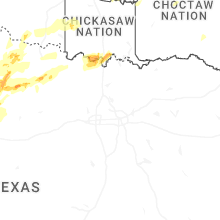
Texas
| Local Time | Report Details |
|---|---|
| 1:28 PM CDT | Quarter sized hail reported near , , 59 miles SSW of Odessa, TX, quarter size reported by emergency manager. time was estimated by report and radar. |
| 1:34 PM CDT | Golf Ball sized hail reported near , , 57.1 miles SSW of Odessa, TX, golf ball sized hail reported by emergency manager. time estimated per report. |
| 2:22 PM CDT | Ping Pong Ball sized hail reported near Tahoka, TX, 31.3 miles SSE of Lubbock, TX, via tahoka fd. |
| 2:29 PM CDT | Ping Pong Ball sized hail reported near Fort Stockton, TX, 58.4 miles NE of Alpine, TX, large hail reported to emergency management. |
| 2:33 PM CDT | Half Dollar sized hail reported near Lubbock, TX, 8.4 miles SW of Lubbock, TX, report from mping: half dollar (1.25 in.). |
| 2:35 PM CDT | Quarter sized hail reported near Wolfforth, TX, 11 miles WSW of Lubbock, TX, report from mping: quarter (1.00 in.). |
| 2:41 PM CDT | Quarter sized hail reported near Lubbock, TX, 6.9 miles WSW of Lubbock, TX, report from mping: quarter (1.00 in.). |
| 2:42 PM CDT | Golf Ball sized hail reported near Tahoka, TX, 33.3 miles SSE of Lubbock, TX, tahoka fd. |
| 2:42 PM CDT | Golf Ball sized hail reported near Wolfforth, TX, 11.8 miles SW of Lubbock, TX, report from mping: golf ball (1.75 in.). |
| 2:44 PM CDT | Quarter sized hail reported near Lubbock, TX, 6.5 miles WSW of Lubbock, TX, report from mping: quarter (1.00 in.). |
| 2:46 PM CDT | Quarter sized hail reported near Lubbock, TX, 3 miles WSW of Lubbock, TX, report from mping: quarter (1.00 in.). |
| 2:51 PM CDT | Half Dollar sized hail reported near Lubbock, TX, 6.9 miles WSW of Lubbock, TX, report from mping: half dollar (1.25 in.). |
| 2:55 PM CDT | Half Dollar sized hail reported near Lubbock, TX, 1.7 miles SSW of Lubbock, TX, report from mping: half dollar (1.25 in.). |
| 2:56 PM CDT | Hen Egg sized hail reported near Lubbock, TX, 2 miles W of Lubbock, TX, report from mping: hen egg (2.00 in.). |
| 3:11 PM CDT | Hen Egg sized hail reported near Post, TX, 33.2 miles SSE of Lubbock, TX, tahoka fd. |
| 3:26 PM CDT | Tea Cup sized hail reported near Post, TX, 37.3 miles SE of Lubbock, TX, media relayed public report. time estimated from radar. |
| 3:28 PM CDT | Tennis Ball sized hail reported near Post, TX, 39.1 miles SE of Lubbock, TX, garza county so. |
| 4:35 PM CDT | Hen Egg sized hail reported near , , 63.4 miles S of Childress, TX, nssl report. |
| 4:41 PM CDT | Softball sized hail reported near Guthrie, TX, 66.1 miles S of Childress, TX, social media video shows 5 inch diameter hail found along the roadside. time estimated from radar. |
| 4:47 PM CDT | Golf Ball sized hail reported near , , 69.6 miles S of Childress, TX, report from mping: golf ball (1.75 in.). |
| 4:51 PM CDT | Grapefruit sized hail reported near Girard, TX, 70.9 miles ESE of Lubbock, TX, kent county so. |
| 4:54 PM CDT | Softball sized hail reported near Guthrie, TX, 66.1 miles S of Childress, TX, mc report. |
| 5:05 PM CDT | Softball sized hail reported near Guthrie, TX, 60.9 miles S of Childress, TX, public report from mping. corrected for location. location estimated from radar. |
| 5:25 PM CDT | Hen Egg sized hail reported near Floydada, TX, 39.9 miles NE of Lubbock, TX, media relayed public report. |
| 5:25 PM CDT | Golf Ball sized hail reported near Floydada, TX, 39.9 miles NE of Lubbock, TX, floydada fd. |
| 5:52 PM CDT | Ping Pong Ball sized hail reported near Aspermont, TX, 62.9 miles NNW of Abilene, TX, report from mping: ping pong ball (1.50 in.). |
| 5:59 PM CDT | Measured at personal statio in knox county TX, 63.3 miles SSE of Childress, TX |
| 6:18 PM CDT | Storm damage reported in knox county TX, 69.3 miles N of Abilene, TX |
| 6:18 PM CDT | Quarter sized hail reported near Knox City, TX, 66.3 miles N of Abilene, TX, report from mping: quarter (1.00 in.). |
| 6:25 PM CDT | Golf Ball sized hail reported near Knox City, TX, 66.3 miles N of Abilene, TX, spotternetwork report. |
| 6:30 PM CDT | Storm damage reported in knox county TX, 69.3 miles N of Abilene, TX |
| 6:40 PM CDT | Storm damage reported in baylor county TX, 48.8 miles WSW of Wichita Falls, TX |
| 6:45 PM CDT | Trees snapped... power lines snapped... roof damage to bar in baylor county TX, 48.9 miles WSW of Wichita Falls, TX |
| 6:45 PM CDT | Quarter sized hail reported near Goree, TX, 69.4 miles WSW of Wichita Falls, TX, report from mping: quarter (1.00 in.). |
| 7:00 PM CDT | Golf Ball sized hail reported near Iraan, TX, 70.5 miles SSE of Odessa, TX, picture of approximately golf ball size hail in iraan. |
| 7:01 PM CDT | Tennis Ball sized hail reported near Seymour, TX, 47 miles WSW of Wichita Falls, TX, report from mping: tennis ball (2.50 in.). |
| 7:08 PM CDT | Storm damage reported in baylor county TX, 50.1 miles WSW of Wichita Falls, TX |
| 7:31 PM CDT | Quarter sized hail reported near Seymour, TX, 30.6 miles WSW of Wichita Falls, TX, report from mping: quarter (1.00 in.). |
| 8:23 PM CDT | Storm damage reported in wichita county TX, 13 miles NNW of Wichita Falls, TX |
| 9:16 PM CDT | Half Dollar sized hail reported near Olney, TX, 46.9 miles SSW of Wichita Falls, TX, report from mping: half dollar (1.25 in.). |
| 9:16 PM CDT | Hen Egg sized hail reported near Olney, TX, 44.8 miles SSW of Wichita Falls, TX, report from mping: hen egg (2.00 in.). |
| 11:06 PM CDT | Golf Ball sized hail reported near Big Spring, TX, 62.8 miles ENE of Odessa, TX, report of golf ball sized hail off of us hwy 87. |
| 12:07 AM CDT | Quarter sized hail reported near Seminole, TX, 67.4 miles SW of Lubbock, TX, media partner reported nickel to quarter sized hail between seagraves and seminole in gaines county... tx along us hwy 62. |
| 1:06 AM CDT | Quarter sized hail reported near Snyder, TX, 70.6 miles WNW of Abilene, TX |
| 1:20 AM CDT | Golf Ball sized hail reported near Hermleigh, TX, 62.3 miles WNW of Abilene, TX |
| 2:21 AM CDT | Quarter sized hail reported near Big Spring, TX, 63.7 miles NE of Odessa, TX, report from mping: quarter (1.00 in.). |
| 3:30 AM CDT | Corrects previous tstm wnd gst report from 5 nw colorado city. mesonet station 5nw colorado cit in mitchell county TX, 68.9 miles W of Abilene, TX |
| 3:59 AM CDT | West texas mesonet observatio in knox county TX, 69.4 miles N of Abilene, TX |
| 4:09 AM CDT | Storm damage reported in knox county TX, 53.9 miles SSE of Childress, TX |
Michigan
| Local Time | Report Details |
|---|---|
| 2:41 PM EDT | Multiple reports of roof partially removed from large buildin in oakland county MI, 28.8 miles SSE of Flint, MI |
| 3:00 PM EDT | A couple trees down near avon rd and rochester rd in oakland county MI, 36.4 miles SE of Flint, MI |
| 3:00 PM EDT | Powerlines down near hamlin rd and john r r in oakland county MI, 38.4 miles SE of Flint, MI |
| 3:10 PM EDT | Pine tree uprooted and a tree limb down several inches in diamete in macomb county MI, 40.8 miles SE of Flint, MI |
| 3:15 PM EDT | Multiple trees and power lines down around macomb townshi in macomb county MI, 45.5 miles ESE of Flint, MI |
| 3:20 PM EDT | Measured at midot sit in macomb county MI, 50.9 miles ESE of Flint, MI |
| 3:20 PM EDT | Large pine tree uprooted and tree limbs up to 6 inches in diameter down. estimated 60 mph wind in st. clair county MI, 54.9 miles ESE of Flint, MI |
| 3:34 PM EDT | 911 dispatch reported powerline down in st. clair county MI, 63.7 miles ESE of Flint, MI |
| 3:34 PM EDT | 911 dispatch reported powerline down on meisner rd in east china townshi in st. clair county MI, 63 miles ESE of Flint, MI |
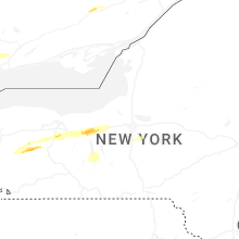
New York
| Local Time | Report Details |
|---|---|
| 3:30 PM EDT | Trees and powerlines down in several towns in the northern portion of the count in wyoming county NY, 30 miles E of Buffalo, NY |
| 3:37 PM EDT | Golf Ball sized hail reported near Warsaw, NY, 38.4 miles ESE of Buffalo, NY, delayed report. golf ball sized hail reported in warsaw. |
| 3:46 PM EDT | Half Dollar sized hail reported near Pavilion, NY, 44.2 miles E of Buffalo, NY, delayed report. 1.25 inch hail measured in covington. |
| 3:46 PM EDT | Delayed report. large trees uprooted in covingto in wyoming county NY, 44.2 miles E of Buffalo, NY |
| 3:53 PM EDT | Trees... powerlines... and power poles down in the town of yor in livingston county NY, 47.6 miles E of Buffalo, NY |
| 3:55 PM EDT | Delayed report. swath of snapped power poles on route 36 north of yor in livingston county NY, 50.7 miles E of Buffalo, NY |
| 3:58 PM EDT | Delayed report... time estimated based on radar. trees and wires down in caledoni in livingston county NY, 51.8 miles E of Buffalo, NY |
| 4:02 PM EDT | Large tree down on a hous in livingston county NY, 57.3 miles E of Buffalo, NY |
| 4:03 PM EDT | Quarter sized hail reported near Holland, NY, 23.2 miles SE of Buffalo, NY |
| 4:04 PM EDT | Trees... powerlines... and power poles dow in livingston county NY, 57.3 miles E of Buffalo, NY |
| 4:10 PM EDT | Quarter sized hail reported near Lima, NY, 64.4 miles E of Buffalo, NY |
| 4:10 PM EDT | Numerous trees and powerlines down in most of the towns in the northern half of wyoming count in wyoming county NY, 36.4 miles E of Buffalo, NY |
| 4:10 PM EDT | Trees down in the town of irondequoi in monroe county NY, 69.9 miles ENE of Buffalo, NY |
| 4:10 PM EDT | Storm damage reported in wyoming county NY, 34.7 miles ESE of Buffalo, NY |
| 4:14 PM EDT | Quarter sized hail reported near Strykersville, NY, 25.4 miles ESE of Buffalo, NY |
| 4:15 PM EDT | Half Dollar sized hail reported near Honeoye Falls, NY, 65.5 miles E of Buffalo, NY, delayed report. photo on social media of half dollar sized hail in honeoye falls. |
| 4:16 PM EDT | Trees down in the town of webste in monroe county NY, 65.3 miles W of Syracuse, NY |
| 4:19 PM EDT | Large tree down blocking county route 3 in ontario county NY, 67.5 miles W of Syracuse, NY |
| 4:20 PM EDT | Large tree down blocking route 44 in ontario county NY, 65.2 miles W of Syracuse, NY |
| 4:22 PM EDT | Tree down blocking victoria l in ontario county NY, 62.6 miles W of Syracuse, NY |
| 4:22 PM EDT | Tree down on hous in ontario county NY, 62.7 miles W of Syracuse, NY |
| 4:26 PM EDT | Large tree down blocking most of sand hill r in ontario county NY, 57.5 miles W of Syracuse, NY |
| 4:28 PM EDT | Tree down blocking roadwa in ontario county NY, 59.1 miles W of Syracuse, NY |
| 4:28 PM EDT | Quarter sized hail reported near Warsaw, NY, 38.8 miles ESE of Buffalo, NY |
| 4:30 PM EDT | Storm damage reported in livingston county NY, 52.2 miles E of Buffalo, NY |
| 4:32 PM EDT | Large tree down partially blocking route 9 in ontario county NY, 54.6 miles W of Syracuse, NY |
| 4:34 PM EDT | Tree down on house on east av in ontario county NY, 54.7 miles W of Syracuse, NY |
| 4:34 PM EDT | Power pole down on ca in ontario county NY, 52.5 miles W of Syracuse, NY |
| 4:35 PM EDT | Power pole snappe in ontario county NY, 50.3 miles W of Syracuse, NY |
| 4:35 PM EDT | Tree down on house on west main s in ontario county NY, 51.2 miles W of Syracuse, NY |
| 4:37 PM EDT | Tree down on a house and powerline in ontario county NY, 50.2 miles W of Syracuse, NY |
| 4:38 PM EDT | Tree down on an unoccupied ca in ontario county NY, 50.7 miles W of Syracuse, NY |
| 4:40 PM EDT | Tree down on a house with roof damage on mary av in ontario county NY, 47.2 miles W of Syracuse, NY |
| 4:40 PM EDT | Large tree down blocking route 8 in ontario county NY, 47.9 miles W of Syracuse, NY |
| 4:40 PM EDT | Trees and powerlines down along stephens s in ontario county NY, 50.7 miles W of Syracuse, NY |
| 4:40 PM EDT | *** 1 inj *** tree down on mobile home with significant damage. 1 occupant injure in ontario county NY, 48.9 miles W of Syracuse, NY |
| 4:40 PM EDT | Large tree down blocking maryland r in ontario county NY, 43.5 miles W of Syracuse, NY |
| 4:40 PM EDT | Delayed report. tree on a house in mcburney road in phelp in ontario county NY, 47.6 miles W of Syracuse, NY |
| 4:42 PM EDT | Trees and wires down on a ca in seneca county NY, 42.6 miles SW of Syracuse, NY |
| 4:42 PM EDT | Large tree down blocking all of cedar swamp r in ontario county NY, 45.9 miles W of Syracuse, NY |
| 4:45 PM EDT | Scattered wind damage in area... including heavy damage to town highway buildings. radar-estimated tim in yates county NY, 57.8 miles SW of Syracuse, NY |
| 4:47 PM EDT | Tree down on wires on near the intersection of dublin road and ninefoot roa in seneca county NY, 39.3 miles W of Syracuse, NY |
| 4:49 PM EDT | A few trees down on w brook roa in seneca county NY, 34.6 miles W of Syracuse, NY |
| 4:52 PM EDT | Trees and wires dow in seneca county NY, 29.1 miles W of Syracuse, NY |
| 4:52 PM EDT | Trees and wires down on sherwood road. time estimated from rada in cayuga county NY, 30.5 miles SW of Syracuse, NY |
| 4:56 PM EDT | Tree down on church street... corrected tim in cayuga county NY, 24.4 miles W of Syracuse, NY |
| 5:01 PM EDT | Tree down on valentine road. time estimated from rada in cayuga county NY, 21.9 miles SW of Syracuse, NY |
| 5:01 PM EDT | Trees down church street. time estimated from rada in cayuga county NY, 23.9 miles W of Syracuse, NY |
| 5:05 PM EDT | Delayed report. multiple trees and wired down in the village of port byron and the town of ment in cayuga county NY, 24 miles W of Syracuse, NY |
| 5:06 PM EDT | Trees and wires down. time estimated from rada in onondaga county NY, 16.4 miles W of Syracuse, NY |
| 5:06 PM EDT | Tree down on a hous in onondaga county NY, 12 miles NW of Syracuse, NY |
| 5:10 PM EDT | Wires dow in onondaga county NY, 10.8 miles WNW of Syracuse, NY |
| 5:20 PM EDT | Trees and powerlines dow in oswego county NY, 16.6 miles N of Syracuse, NY |
| 5:22 PM EDT | At syracuse airpor in onondaga county NY, 4.9 miles N of Syracuse, NY |
| 5:22 PM EDT | Trees and wires dow in onondaga county NY, 4 miles E of Syracuse, NY |
| 5:22 PM EDT | Trees and powerlines dow in oswego county NY, 16.4 miles NNE of Syracuse, NY |
| 5:23 PM EDT | Large tree branch (approx. 20 ft long... 1 foot in diameter) fell in drivewa in onondaga county NY, 4.2 miles N of Syracuse, NY |
| 5:33 PM EDT | Trees and powerlines dow in oswego county NY, 18.5 miles NE of Syracuse, NY |
| 5:34 PM EDT | Tree down on devaul r in madison county NY, 11.8 miles ENE of Syracuse, NY |
| 5:34 PM EDT | Tree down on car with wires involved. no injuries reporte in madison county NY, 13.3 miles ENE of Syracuse, NY |
| 5:35 PM EDT | Tree and several powerlines dow in cattaraugus county NY, 60.1 miles SSE of Buffalo, NY |
| 5:38 PM EDT | Metal docks thrown. minor roof damage to house. pictures shared on social medi in oneida county NY, 23.3 miles ENE of Syracuse, NY |
| 5:43 PM EDT | Multiple trees and wires down across vienn in oneida county NY, 24.9 miles ENE of Syracuse, NY |
| 5:51 PM EDT | Tree on house... person trapped in basemen in oneida county NY, 38.3 miles ENE of Syracuse, NY |
| 5:56 PM EDT | Tree down on wire in oneida county NY, 50.4 miles NE of Syracuse, NY |
| 6:00 PM EDT | At griffiss international airpor in oneida county NY, 35.5 miles ENE of Syracuse, NY |
| 6:00 PM EDT | Tree on trailer... 5 people trapped in trailer. unknown injurie in oneida county NY, 42 miles ENE of Syracuse, NY |
| 6:04 PM EDT | Multiple trees and wires down near o brien road and north lake road. time estimated from rada in oneida county NY, 55.4 miles ENE of Syracuse, NY |
| 6:04 PM EDT | Several trees down and snapped in half in the area of division street and river road. time estimated from rada in oneida county NY, 54.4 miles ENE of Syracuse, NY |
| 6:13 PM EDT | Several trees snapped and downed along short cut r in herkimer county NY, 62.3 miles ENE of Syracuse, NY |
| 6:13 PM EDT | Report of trees down on barnhart roa in herkimer county NY, 60.3 miles ENE of Syracuse, NY |
| 6:15 PM EDT | Report of trees down on state route in herkimer county NY, 62.3 miles ENE of Syracuse, NY |
| 6:30 PM EDT | Tree down on state route 5 in yates county NY, 57.4 miles SW of Syracuse, NY |
| 6:33 PM EDT | Tree on roa in yates county NY, 54.6 miles WSW of Syracuse, NY |
| 6:38 PM EDT | Multiple reports of trees and wires down in cameron. time estimated from rada in steuben county NY, 87.1 miles SW of Syracuse, NY |
| 6:38 PM EDT | Roof blown off unoccupied house. wires also dow in yates county NY, 50.4 miles SW of Syracuse, NY |
| 6:50 PM EDT | Power lines dow in steuben county NY, 78 miles SW of Syracuse, NY |
| 6:52 PM EDT | Reports of trees down in well in hamilton county NY, 43.6 miles NNW of Schenectady, NY |
| 6:59 PM EDT | Trees and wires down on hornby road. time estimated from rada in steuben county NY, 72.1 miles SW of Syracuse, NY |
| 7:01 PM EDT | Trees down on searls road. time estimated from rada in cortland county NY, 27 miles S of Syracuse, NY |
| 7:05 PM EDT | Trees and wires down on morgan hill road. time estimated from rada in cortland county NY, 24.6 miles SSE of Syracuse, NY |
| 7:11 PM EDT | Trees down in cortland. time estimated from rada in cortland county NY, 31.1 miles S of Syracuse, NY |
| 7:23 PM EDT | Several reports of trees and wires down in the count in chemung county NY, 71.5 miles SSW of Syracuse, NY |
| 7:35 PM EDT | Trees down on route 41. time estimated from rada in cortland county NY, 41.8 miles SSE of Syracuse, NY |
| 7:43 PM EDT | Trees down on hammerle road. time estimated from rada in chenango county NY, 47.2 miles SSE of Syracuse, NY |
| 7:47 PM EDT | Trees down on north broad street in norwich. time estimated from rada in chenango county NY, 47.2 miles SE of Syracuse, NY |
| 7:47 PM EDT | Trees down on hale road. time estimated from rada in chenango county NY, 46.3 miles SE of Syracuse, NY |
| 8:02 PM EDT | Trees and wires down in the are in otsego county NY, 57.2 miles SE of Syracuse, NY |
| 8:20 PM EDT | Transformer on fir in otsego county NY, 53.6 miles WSW of Schenectady, NY |
| 8:22 PM EDT | Estimate in otsego county NY, 51.6 miles WSW of Schenectady, NY |
Pennsylvania
| Local Time | Report Details |
|---|---|
| 4:07 PM EDT | Tree down on iron city driv in allegheny county PA, 3.5 miles WSW of Pittsburgh, PA |
| 4:09 PM EDT | Trees down on edgebrook av in allegheny county PA, 2.7 miles SSW of Pittsburgh, PA |
| 4:40 PM EDT | Trees down on christy and hann hill roa in mercer county PA, 59.3 miles NNW of Pittsburgh, PA |
| 4:48 PM EDT | Trees down along rt 16 in beaver county PA, 26.1 miles WNW of Pittsburgh, PA |
| 4:49 PM EDT | Trees uprooted in frankfort spring in beaver county PA, 23.5 miles W of Pittsburgh, PA |
| 4:53 PM EDT | Trees down on sunset blv in lawrence county PA, 32.7 miles NNW of Pittsburgh, PA |
| 4:53 PM EDT | Tree down on woodlane av in beaver county PA, 28 miles WNW of Pittsburgh, PA |
| 4:54 PM EDT | Power pole leaning over near us-22 and pa route 1 in washington county PA, 22.8 miles W of Pittsburgh, PA |
| 4:56 PM EDT | Trees dow in allegheny county PA, 13.3 miles W of Pittsburgh, PA |
| 4:56 PM EDT | Trees dow in beaver county PA, 21.8 miles NW of Pittsburgh, PA |
| 4:56 PM EDT | Street light blown down at beaver valley mal in beaver county PA, 22.9 miles NW of Pittsburgh, PA |
| 4:57 PM EDT | Tree blocking one lane of mill street at broadhead intersectio in beaver county PA, 19 miles NW of Pittsburgh, PA |
| 4:58 PM EDT | Numerous trees dow in beaver county PA, 20.3 miles NW of Pittsburgh, PA |
| 4:59 PM EDT | Tree down on a power lin in allegheny county PA, 13.2 miles WNW of Pittsburgh, PA |
| 5:00 PM EDT | Large tree down on a hous in allegheny county PA, 13.6 miles NW of Pittsburgh, PA |
| 5:01 PM EDT | Asos station kpit pittsburgh intl airpor in allegheny county PA, 15 miles WNW of Pittsburgh, PA |
| 5:02 PM EDT | Cinderblock garage corner dislocated near south fayette school in allegheny county PA, 10.2 miles WSW of Pittsburgh, PA |
| 5:03 PM EDT | Multiple trees were blown down on falck rd. damage to a garage roof and deck also reporte in allegheny county PA, 7.7 miles WNW of Pittsburgh, PA |
| 5:03 PM EDT | Numerous trees... wires and power poles down throughout the are in beaver county PA, 29.5 miles NW of Pittsburgh, PA |
| 5:03 PM EDT | Large tree limbs also dow in washington county PA, 14.8 miles SW of Pittsburgh, PA |
| 5:05 PM EDT | Large tree dow in allegheny county PA, 8.2 miles SSW of Pittsburgh, PA |
| 5:06 PM EDT | Trees down along chartiers creek. awnings off of buildings and power lines also dow in allegheny county PA, 5.5 miles WSW of Pittsburgh, PA |
| 5:06 PM EDT | Several trees and large limbs dow in allegheny county PA, 3.6 miles NW of Pittsburgh, PA |
| 5:07 PM EDT | Part of a tree on home on dewalt driv in allegheny county PA, 4.2 miles SSW of Pittsburgh, PA |
| 5:07 PM EDT | Trees down on august driv in allegheny county PA, 7.6 miles WNW of Pittsburgh, PA |
| 5:07 PM EDT | Corrects previous tstm wnd dmg report from green tree. tree down on iron city driv in allegheny county PA, 3.5 miles WSW of Pittsburgh, PA |
| 5:08 PM EDT | Large limbs also dow in allegheny county PA, 3.5 miles SW of Pittsburgh, PA |
| 5:08 PM EDT | Trees blown dow in allegheny county PA, 9.7 miles S of Pittsburgh, PA |
| 5:08 PM EDT | Several limbs dow in allegheny county PA, 5.7 miles NNW of Pittsburgh, PA |
| 5:08 PM EDT | Shutters blown off of houses. siding also blown of in allegheny county PA, 12.3 miles NNW of Pittsburgh, PA |
| 5:08 PM EDT | Trees and wires dow in washington county PA, 21.6 miles SSW of Pittsburgh, PA |
| 5:09 PM EDT | Tree on a home on fruithurst d in allegheny county PA, 4.4 miles SSW of Pittsburgh, PA |
| 5:09 PM EDT | Corrects previous tstm wnd dmg report from 1 ene dormont. trees down on edgebrook av in allegheny county PA, 2.7 miles SSW of Pittsburgh, PA |
| 5:09 PM EDT | 6 trees blown dow in allegheny county PA, 5.2 miles SSW of Pittsburgh, PA |
| 5:09 PM EDT | Tree dow in butler county PA, 18.5 miles NNW of Pittsburgh, PA |
| 5:10 PM EDT | Corrects previous non-tstm wnd gst report from 1 wsw pearl. meausred wind gust from pennsylvania mesonet senso in venango county PA, 57.5 miles N of Pittsburgh, PA |
| 5:10 PM EDT | Multiple trees down and shingles blown off of a roo in allegheny county PA, 2 miles SSE of Pittsburgh, PA |
| 5:10 PM EDT | Large tree in the roa in allegheny county PA, 4.8 miles S of Pittsburgh, PA |
| 5:10 PM EDT | Roof blown off restaurant along west liberty av in allegheny county PA, 2.3 miles SSW of Pittsburgh, PA |
| 5:10 PM EDT | Numerous large trees... power lines... and power poles blown down throughout the area. lasted approximately 10 minute in allegheny county PA, 5.6 miles SSE of Pittsburgh, PA |
| 5:11 PM EDT | Tree down on a house. numerous trees and wires down throughout this are in allegheny county PA, 8.5 miles SSW of Pittsburgh, PA |
| 5:11 PM EDT | Tree and large limbs down. metal chimney cover also blown dow in allegheny county PA, 1.3 miles S of Pittsburgh, PA |
| 5:11 PM EDT | Uprooted trees on christler stree in allegheny county PA, 4.9 miles NNE of Pittsburgh, PA |
| 5:12 PM EDT | Numerous trees uprooted and snapped in schenley par in allegheny county PA, 3.6 miles E of Pittsburgh, PA |
| 5:13 PM EDT | Multiple trees dow in allegheny county PA, 6.3 miles NE of Pittsburgh, PA |
| 5:13 PM EDT | Tree down on wire in butler county PA, 20.2 miles N of Pittsburgh, PA |
| 5:13 PM EDT | Tree damage at the pittsburgh zo in allegheny county PA, 5 miles NE of Pittsburgh, PA |
| 5:13 PM EDT | Trees and power lines down on beverly roa in allegheny county PA, 4.7 miles SW of Pittsburgh, PA |
| 5:13 PM EDT | Trees down on eastview driv in allegheny county PA, 9.1 miles N of Pittsburgh, PA |
| 5:13 PM EDT | Large tree snappe in allegheny county PA, 6.8 miles NNE of Pittsburgh, PA |
| 5:14 PM EDT | Numerous trees dow in allegheny county PA, 7.5 miles NNE of Pittsburgh, PA |
| 5:14 PM EDT | Tree and wires dow in butler county PA, 25.2 miles NNW of Pittsburgh, PA |
| 5:14 PM EDT | Trees down on beechwood blv in allegheny county PA, 3.1 miles E of Pittsburgh, PA |
| 5:15 PM EDT | Tree dow in allegheny county PA, 3.8 miles ESE of Pittsburgh, PA |
| 5:15 PM EDT | Tree down on power line in greene county PA, 40.8 miles SSW of Pittsburgh, PA |
| 5:15 PM EDT | Multiple trees dow in allegheny county PA, 11.9 miles ESE of Pittsburgh, PA |
| 5:15 PM EDT | Tree down in the front yar in allegheny county PA, 9.4 miles E of Pittsburgh, PA |
| 5:15 PM EDT | Windows blown out of high rise building in downtown pittsburgh. gates cente in allegheny county PA, 0.2 miles NW of Pittsburgh, PA |
| 5:15 PM EDT | Numerous trees uprooted and large branches dow in allegheny county PA, 6.7 miles E of Pittsburgh, PA |
| 5:16 PM EDT | Trees down near thomas blv in allegheny county PA, 5.2 miles E of Pittsburgh, PA |
| 5:17 PM EDT | Corrects previous tstm wnd dmg report from 3 e nixon. numerous trees down... some on power lines. power pole blown down... and a horse trailer was damaged by a falling in butler county PA, 24.5 miles NNE of Pittsburgh, PA |
| 5:19 PM EDT | Tree down near the churc in butler county PA, 23.1 miles N of Pittsburgh, PA |
| 5:19 PM EDT | Numerous trees down across the are in greene county PA, 36.2 miles SSW of Pittsburgh, PA |
| 5:20 PM EDT | Wires dow in butler county PA, 18.2 miles N of Pittsburgh, PA |
| 5:21 PM EDT | Trees down on pa turnpike mp 43.8... blocking lanes of traffi in allegheny county PA, 11.6 miles NE of Pittsburgh, PA |
| 5:21 PM EDT | Tree snapped on freeport road and saxonburg roa in butler county PA, 28.4 miles NNE of Pittsburgh, PA |
| 5:21 PM EDT | Shutters blown off of a house. truck cover blown of in westmoreland county PA, 15.5 miles ESE of Pittsburgh, PA |
| 5:22 PM EDT | Car stuck in downed powerline in butler county PA, 26.6 miles N of Pittsburgh, PA |
| 5:22 PM EDT | Tree on a home on hazelnut driv in allegheny county PA, 12 miles E of Pittsburgh, PA |
| 5:22 PM EDT | Tree on a car on hamlet court in monroevill in allegheny county PA, 12.5 miles E of Pittsburgh, PA |
| 5:23 PM EDT | Trees down on new texas r in allegheny county PA, 14.4 miles ENE of Pittsburgh, PA |
| 5:23 PM EDT | Power pole down on stevenson blv in westmoreland county PA, 15.9 miles NE of Pittsburgh, PA |
| 5:23 PM EDT | Multiple trees down in brackenridge p in allegheny county PA, 17.6 miles NE of Pittsburgh, PA |
| 5:23 PM EDT | Trees dow in butler county PA, 23.7 miles NNE of Pittsburgh, PA |
| 5:23 PM EDT | Numerous trees dow in butler county PA, 24 miles NNE of Pittsburgh, PA |
| 5:23 PM EDT | Large oak tree uprooted and into bar in westmoreland county PA, 14.8 miles E of Pittsburgh, PA |
| 5:23 PM EDT | *** 1 inj *** tree fell on a car injuring occupan in greene county PA, 37.3 miles SSW of Pittsburgh, PA |
| 5:24 PM EDT | Numerous large limbs down. shingles blown off of a roo in westmoreland county PA, 19.3 miles ENE of Pittsburgh, PA |
| 5:25 PM EDT | Tree dow in armstrong county PA, 23.6 miles NE of Pittsburgh, PA |
| 5:25 PM EDT | Large trees and limbs dow in westmoreland county PA, 19.4 miles E of Pittsburgh, PA |
| 5:25 PM EDT | Trees down around monroeville public librar in allegheny county PA, 13.1 miles E of Pittsburgh, PA |
| 5:25 PM EDT | Reports of several trees snapped and uprooted near memorial park and the 56 bypass. time estimated from rada in westmoreland county PA, 15.9 miles NE of Pittsburgh, PA |
| 5:25 PM EDT | Trees split in half and limbs dow in westmoreland county PA, 18 miles E of Pittsburgh, PA |
| 5:25 PM EDT | Trees down in sarver are in butler county PA, 22.2 miles NNE of Pittsburgh, PA |
| 5:25 PM EDT | 7 trees blown down in butler county PA, 22.4 miles NE of Pittsburgh, PA |
| 5:27 PM EDT | Trees dow in westmoreland county PA, 16.2 miles E of Pittsburgh, PA |
| 5:31 PM EDT | Numerous trees dow in westmoreland county PA, 22.2 miles E of Pittsburgh, PA |
| 5:33 PM EDT | Widespread damage across huntington townshi in westmoreland county PA, 16.6 miles ESE of Pittsburgh, PA |
| 5:35 PM EDT | Tree down in yar in westmoreland county PA, 26 miles ESE of Pittsburgh, PA |
| 5:39 PM EDT | Five 2-foot in diameter power poles snapped and laying on the groun in armstrong county PA, 38.3 miles ENE of Pittsburgh, PA |
| 5:42 PM EDT | Multiple trees dow in indiana county PA, 35.9 miles ENE of Pittsburgh, PA |
| 5:43 PM EDT | Trees uprooted. one tree down on a power lin in indiana county PA, 36.1 miles E of Pittsburgh, PA |
| 5:44 PM EDT | Numerous trees uprooted. damage to a roo in indiana county PA, 40 miles ENE of Pittsburgh, PA |
| 5:44 PM EDT | Trees dow in westmoreland county PA, 31.7 miles ESE of Pittsburgh, PA |
| 5:45 PM EDT | Measured at klbe latrobe airpor in westmoreland county PA, 33.6 miles ESE of Pittsburgh, PA |
| 5:45 PM EDT | Numerous trees down... some on power lines. power pole blown down... and a horse trailer was damaged by a falling tre in butler county PA, 24.5 miles NNE of Pittsburgh, PA |
| 5:46 PM EDT | Multiple trees were blown dow in indiana county PA, 38.4 miles E of Pittsburgh, PA |
| 5:54 PM EDT | Tree down on metz rd near route 42 in indiana county PA, 49.6 miles ENE of Pittsburgh, PA |
| 5:56 PM EDT | Tree down on lutz school roa in indiana county PA, 48.9 miles ENE of Pittsburgh, PA |
| 6:00 PM EDT | Mesonet station at365 rochester mill in indiana county PA, 55.4 miles ENE of Pittsburgh, PA |
| 6:00 PM EDT | Large tree limbs dow in indiana county PA, 53.7 miles ENE of Pittsburgh, PA |
| 6:05 PM EDT | Trees down on wires with a transformer down across north sheridan street in johnstow in cambria county PA, 56.1 miles E of Pittsburgh, PA |
| 6:12 PM EDT | Tree uprooted along colver road near ebensbur in cambria county PA, 49.9 miles WSW of State College, PA |
| 6:12 PM EDT | Asos wind gust at kjst airpor in cambria county PA, 60.6 miles WSW of State College, PA |
| 6:14 PM EDT | Cell tower collapsed on sunset roa in cambria county PA, 44.8 miles WSW of State College, PA |
| 6:16 PM EDT | Trees down across wires along glades pike roa in somerset county PA, 52.9 miles ESE of Pittsburgh, PA |
| 6:18 PM EDT | Reports of a barn collapse on the 800 block of munster road in portage township. animals trapped inside of the collaps in cambria county PA, 50.2 miles WSW of State College, PA |
| 6:18 PM EDT | Trees down on wires across lincoln drive in duboi in clearfield county PA, 52.5 miles WNW of State College, PA |
| 6:22 PM EDT | Asos station kduj dubois airpor in jefferson county PA, 60.2 miles WNW of State College, PA |
| 6:28 PM EDT | Trees and wires down across wopsy road near the lookou in blair county PA, 34.6 miles WSW of State College, PA |
| 6:30 PM EDT | Tree down onto a residence driveway with multiple large branches snapped off of tree in clearfield county PA, 51.2 miles WNW of State College, PA |
| 6:30 PM EDT | Tree fell onto a car with no injuries reporte in blair county PA, 40.8 miles SW of State College, PA |
| 6:31 PM EDT | Reports of a tree down on a residence on 7th avenue. multiple trees and wires down across altoon in blair county PA, 33.6 miles SW of State College, PA |
| 6:31 PM EDT | Large tree with wires down near a residence and car... blocking entrances and exit in blair county PA, 35.7 miles SW of State College, PA |
| 6:32 PM EDT | Trees and wires knocked down onto a residenc in clearfield county PA, 49.5 miles NW of State College, PA |
| 6:35 PM EDT | Trees down on wires along decatur street west of philipsbur in clearfield county PA, 21 miles WNW of State College, PA |
| 6:35 PM EDT | Wires and telephone poles knocked down with three barn roofs blown of in blair county PA, 26.9 miles SW of State College, PA |
| 6:37 PM EDT | Reports of multiple trees into a residence with no injuries reporte in blair county PA, 18 miles WSW of State College, PA |
| 6:38 PM EDT | Multiple trees down in roaring sprin in blair county PA, 41.9 miles SW of State College, PA |
| 6:42 PM EDT | Multiple trees and wires down in grassfla in clearfield county PA, 19.3 miles NW of State College, PA |
| 6:44 PM EDT | Storm damage reported in blair county PA, 41.8 miles SW of State College, PA |
| 6:45 PM EDT | Trees down on wires along route 30 in huntingdon county PA, 16.6 miles SSW of State College, PA |
| 6:46 PM EDT | Numerous trees and wires down along spruce creek roa in huntingdon county PA, 15.2 miles SW of State College, PA |
| 6:49 PM EDT | Power poles snapped in graysdal in centre county PA, 4.8 miles WNW of State College, PA |
| 6:49 PM EDT | Widepsread trees and wires down in huntingdon. power out at 911 cente in huntingdon county PA, 21.7 miles SSW of State College, PA |
| 6:50 PM EDT | Tree knocked down onto a residence on country hills drive. no injuries reporte in huntingdon county PA, 23.9 miles SSW of State College, PA |
| 6:51 PM EDT | Trees and wires down onto a residence on east hillside avenue. no injuries reporte in centre county PA, 2.8 miles WNW of State College, PA |
| 6:51 PM EDT | Numerous trees and wires down along nixon road. 66 mph wind gust. zero visibility ahead of the squall in blowing dus in centre county PA, 3.5 miles SW of State College, PA |
| 6:52 PM EDT | 65 mph wind gust at the national weather service office in state colleg in centre county PA, 2.6 miles NNE of State College, PA |
| 6:52 PM EDT | Tree down into an apartment building. no injuries reporte in centre county PA, 2.1 miles WNW of State College, PA |
| 6:56 PM EDT | Storm damage reported in centre county PA, 13.3 miles NE of State College, PA |
| 6:57 PM EDT | Reports of roof and structural damage northeast of houservill in centre county PA, 4.2 miles NE of State College, PA |
| 6:57 PM EDT | Power line down on a vehicle with multiple trees down in the vicinity of cricklewood drive and fox hollow roa in centre county PA, 2.7 miles NNW of State College, PA |
| 6:57 PM EDT | Large trees knocked down on hillcrest avenue near west cherry lane and orlando avenu in centre county PA, 1 miles WSW of State College, PA |
| 6:58 PM EDT | Reports of a tree on a residence with a tree also down in a yard near the intersection of south patterson street and south sparks stree in centre county PA, 0.6 miles WSW of State College, PA |
| 6:58 PM EDT | Tree down onto an apartment building in bellefonte. no injuries reporte in centre county PA, 9.1 miles NNE of State College, PA |
| 6:59 PM EDT | Trees and wires down across college avenue near pleasant ga in centre county PA, 6.1 miles NE of State College, PA |
| 7:00 PM EDT | At least 9 power poles snapped with wires/poles on roadway along west college ave near cato drive and whitehall road... ferguson township. at least two occupied vehicle in centre county PA, 0.9 miles S of State College, PA |
| 7:03 PM EDT | Multiple trees down on ferguson valley rd. time estimated using rada in mifflin county PA, 21.3 miles S of State College, PA |
| 7:08 PM EDT | Reports of a barn collapse on the 1000 block of dry run road with debris from the collapse blocking the roadwa in clinton county PA, 27.5 miles NE of State College, PA |
| 7:09 PM EDT | Multiple trees snapped and uprooted southeast of howar in centre county PA, 18.4 miles NE of State College, PA |
| 7:09 PM EDT | Widespread trees and wires down near lama in clinton county PA, 22.9 miles NE of State College, PA |
| 7:11 PM EDT | Trees down on wires across west 3rd street in lewistow in mifflin county PA, 19.9 miles SE of State College, PA |
| 7:11 PM EDT | Multiple trees reported down south of millhei in centre county PA, 19.3 miles ENE of State College, PA |
| 7:15 PM EDT | Numerous trees and wires down along route 522 near alfarat in mifflin county PA, 22.5 miles ESE of State College, PA |
| 7:19 PM EDT | Multiple trees down on wires across mckinley road near honey grov in juniata county PA, 27.3 miles SSE of State College, PA |
| 7:19 PM EDT | Trees down on a barn near west valley roa in clinton county PA, 30.5 miles ENE of State College, PA |
| 7:20 PM EDT | Multiple trees down blocking the roadway on arch rock roa in juniata county PA, 26.4 miles ESE of State College, PA |
| 7:23 PM EDT | High tension wires knocked down in the vicinity of whitetail trai in clinton county PA, 34.4 miles ENE of State College, PA |
| 7:25 PM EDT | Trees down across and blocking route 333 near port roya in juniata county PA, 29.9 miles SE of State College, PA |
| 7:26 PM EDT | Multiple trees down near the intersection of thompson road and route 35 nort in juniata county PA, 32 miles ESE of State College, PA |
| 7:29 PM EDT | Numerous trees down across wires in beavertow in snyder county PA, 36.3 miles E of State College, PA |
| 7:30 PM EDT | Trees down 2800 block rt 660... covington townshi in tioga county PA, 76.5 miles WNW of Scranton, PA |
| 7:40 PM EDT | Trees down 900 block wildwood av in lycoming county PA, 52.8 miles NE of State College, PA |
| 7:45 PM EDT | Multiple reports of trees and wires down in williamspor in lycoming county PA, 53.7 miles NE of State College, PA |
| 7:46 PM EDT | Reports of a building collapse on julia street in sunbur in northumberland county PA, 56.4 miles E of State College, PA |
| 7:47 PM EDT | Measured wind on the route 147 bridge near the fabrida in northumberland county PA, 55.2 miles E of State College, PA |
| 7:47 PM EDT | Numerous trees and wires down along route 1 in snyder county PA, 54.2 miles E of State College, PA |
| 7:57 PM EDT | Multiple trees down in halifax township... blocking roadway in dauphin county PA, 53.7 miles ESE of State College, PA |
| 7:58 PM EDT | Reports of a roof blowing of a structure on the 6000 block of state route 118. the roof blowing off also knocked over a 1000 gallon propane tan in lycoming county PA, 50.9 miles WSW of Scranton, PA |
| 8:04 PM EDT | Tree down on brocktown road. time estimated from rada in bradford county PA, 47.2 miles WNW of Scranton, PA |
| 8:05 PM EDT | Numerous trees and wires down in valley vie in schuylkill county PA, 69.7 miles SW of Scranton, PA |
| 8:05 PM EDT | Trees and wires down along route 48 in columbia county PA, 41.9 miles WSW of Scranton, PA |
| 8:06 PM EDT | Trees and wires down along route 42 in numidi in columbia county PA, 53.2 miles SW of Scranton, PA |
| 8:22 PM EDT | Tree down on demunds road. time estimated from rada in wyoming county PA, 14 miles W of Scranton, PA |
| 8:22 PM EDT | Tree down on meshoppen creek road. time estimated from rada in wyoming county PA, 23.6 miles NW of Scranton, PA |
| 8:24 PM EDT | Railroad gate knocked over from wind. time estimated from rada in wyoming county PA, 17.5 miles WNW of Scranton, PA |
West Virginia
| Local Time | Report Details |
|---|---|
| 4:40 PM EDT | Tree damage in area. time estimate in brooke county WV, 37.3 miles WSW of Pittsburgh, PA |
| 4:41 PM EDT | Numerous trees and power lines dow in brooke county WV, 32.1 miles WSW of Pittsburgh, PA |
| 4:42 PM EDT | Numerous trees down blocking road in hancock county WV, 32 miles W of Pittsburgh, PA |
| 4:42 PM EDT | Siding removed off home on miller av in hancock county WV, 27.7 miles W of Pittsburgh, PA |
| 4:44 PM EDT | Numerous trees dow in ohio county WV, 43.3 miles WSW of Pittsburgh, PA |
| 4:44 PM EDT | A lot of tree damage and roof damage to homes along washington pik in brooke county WV, 33.4 miles WSW of Pittsburgh, PA |
| 4:45 PM EDT | Tree down on veterans blv in hancock county WV, 31.3 miles WNW of Pittsburgh, PA |
| 4:46 PM EDT | Tree down on a buildin in ohio county WV, 44.1 miles SW of Pittsburgh, PA |
| 4:52 PM EDT | Trees uproote in ohio county WV, 38.6 miles SW of Pittsburgh, PA |
| 4:56 PM EDT | Tree down in glen dal in marshall county WV, 52.2 miles SW of Pittsburgh, PA |
| 5:00 PM EDT | Trees down in dallas... w in marshall county WV, 40.3 miles SW of Pittsburgh, PA |
| 5:02 PM EDT | At hlg airpor in ohio county WV, 38.8 miles WSW of Pittsburgh, PA |
| 5:29 PM EDT | Tree down on route in wetzel county WV, 71.6 miles SW of Pittsburgh, PA |
| 6:21 PM EDT | Trees and power lines dow in marion county WV, 41.7 miles NNW of Elkins, WV |
| 8:56 PM EDT | Tree down in the road 13800 block of route 52 south of prichard. time estimated by rada in wayne county WV, 52.5 miles W of Charleston, WV |
| 9:25 PM EDT | Downed tree reported on martins branch road. time estimated from rada in putnam county WV, 16.4 miles W of Charleston, WV |
| 9:30 PM EDT | Downed trees and lines reported along coal river road and strawberry road between saint albans and tornado. time estimated from rada in kanawha county WV, 12.2 miles W of Charleston, WV |
| 9:30 PM EDT | Downed tree reported on robin road. time estimated from rada in kanawha county WV, 10.7 miles WNW of Charleston, WV |
| 9:36 PM EDT | Putnam county 911 center reports a large oak tree down on lower coach rd in hurricane and fell on a power pole causing power outage in the area. time estimated by radar in putnam county WV, 21.8 miles WNW of Charleston, WV |
| 9:38 PM EDT | Tree down blocking half the road in the 40 block of stuart circle in hurricane. time estimated via rada in putnam county WV, 20 miles WNW of Charleston, WV |
| 9:41 PM EDT | Tree down blocking the entire road at 5500 block of manilla creek rd. time estimated via rada in putnam county WV, 16 miles NNW of Charleston, WV |
| 9:44 PM EDT | Tree down on home near valley view driv in putnam county WV, 21.4 miles WNW of Charleston, WV |
| 9:48 PM EDT | Downed tree reported on sunset driv in kanawha county WV, 8.8 miles W of Charleston, WV |
| 9:55 PM EDT | Downed tree reported near the interstate 64 eastbound entrance ram in kanawha county WV, 5.5 miles W of Charleston, WV |
| 9:57 PM EDT | Power lines down 900 block of deerwalk highway. time estimated by rada in wood county WV, 67.9 miles N of Charleston, WV |
| 9:59 PM EDT | Tree damage resulting in 432 customers without powe in kanawha county WV, 11.4 miles E of Charleston, WV |
| 10:00 PM EDT | Tree reported dow in kanawha county WV, 6.8 miles NE of Charleston, WV |
| 10:00 PM EDT | Downed tree reported on shields hill road between long run and big run. time estimated from rada in ritchie county WV, 65.6 miles NNE of Charleston, WV |
| 10:00 PM EDT | Downed tree reported on elk river road at hayes street. time estimated from rada in kanawha county WV, 13.6 miles NE of Charleston, WV |
| 10:00 PM EDT | Downed tree reported on elk river road near falling rock. time estimated from rada in kanawha county WV, 14.6 miles ENE of Charleston, WV |
| 10:21 PM EDT | Tree down blocking the road with power lines 6300 block of auburn rd. time estimated by rada in ritchie county WV, 60.1 miles WNW of Elkins, WV |
| 10:23 PM EDT | Tree down blocking one lane of cairo rd at cherokee lane near cairo... wv. time estimated by rada in ritchie county WV, 64 miles NNE of Charleston, WV |
| 10:28 PM EDT | Tree reported down blocking one lane of cannelton hollow road. time is estimated by rada in fayette county WV, 23.5 miles ESE of Charleston, WV |
| 10:40 PM EDT | Large tree limb reported down on route 60. time is estimated by rada in fayette county WV, 29.3 miles ESE of Charleston, WV |
| 10:47 PM EDT | Tree reported down in gassaway. time is estimated by rada in braxton county WV, 52.3 miles ENE of Charleston, WV |
| 10:55 PM EDT | Tree reported down in sutton. time is estimated by rada in braxton county WV, 50.1 miles WSW of Elkins, WV |
| 10:57 PM EDT | Tree reported down in newville. time is estimated by rada in braxton county WV, 43.6 miles WSW of Elkins, WV |
| 11:10 PM EDT | Two trees down across rt 2 in nicholas county WV, 53.1 miles ESE of Charleston, WV |
| 11:14 PM EDT | Asos station kckb clarksburg airpor in harrison county WV, 32.9 miles NW of Elkins, WV |
| 11:14 PM EDT | Upshur 911 reports a tree down on stony run rd about a half a mile from brushy fork rd. time estimated via rada in upshur county WV, 23.2 miles W of Elkins, WV |
| 11:16 PM EDT | Tree down blocking sauls run rd near the 1030 block. tree is estimated to be 20 feet long. time estimated by rada in upshur county WV, 26.1 miles WNW of Elkins, WV |
| 11:16 PM EDT | Power lines down 4000 block of alton rd. there is a small fire associated with the lines being down. time estimated via rada in upshur county WV, 22.8 miles W of Elkins, WV |
| 11:20 PM EDT | Tree down blocking both lanes of hall rd between fishing camp rd and macedonia rd outside of buckhannon. time estimated by rada in upshur county WV, 19.2 miles WNW of Elkins, WV |
| 11:30 PM EDT | Tree down blocking cherry hill rd. time estimated by rada in barbour county WV, 19.8 miles NW of Elkins, WV |
| 11:37 PM EDT | Asos station kekn elkins airpor in randolph county WV, 3 miles S of Elkins, WV |
| 11:51 PM EDT | Tree down across cherry hill roa in barbour county WV, 22.7 miles NW of Elkins, WV |
| 12:06 AM EDT | Tree down across stewart run roa in barbour county WV, 22.9 miles NW of Elkins, WV |
| 12:10 AM EDT | 1 tree down across williams river roa in pocahontas county WV, 50.6 miles SSW of Elkins, WV |
| 12:10 AM EDT | 2 trees down across allegheny highwa in randolph county WV, 10.6 miles E of Elkins, WV |
Kentucky
| Local Time | Report Details |
|---|---|
| 5:56 PM EDT | Quarter sized hail reported near Frankfort, KY, 52.2 miles ENE of Louisville, KY, report from mping: quarter (1.00 in.). |
| 6:09 PM EDT | Large tree down across cisselville rd near loretto rd intersectio in washington county KY, 31.5 miles SE of Louisville, KY |
| 6:12 PM EDT | Quarter sized hail reported near Stamping Ground, KY, 54.5 miles NW of Irvine, KY, twitter report shows picture of quarter size hail. |
| 7:12 PM EDT | Two trees down on stoney point rd. time estimated from rada in bourbon county KY, 31.9 miles NNW of Irvine, KY |
| 7:13 PM EDT | Large tree downed over wooden fencin in kenton county KY, 11.5 miles SSW of Cincinnati, OH |
| 7:16 PM EDT | Large tree downed along independence station road. time estimated by rada in kenton county KY, 10.5 miles SSW of Cincinnati, OH |
| 7:17 PM EDT | Multiple trees reported down around winchester... k in clark county KY, 24.1 miles NNW of Irvine, KY |
| 7:18 PM EDT | Large tree uprooted in independence. time estimated by rada in kenton county KY, 11.1 miles SSW of Cincinnati, OH |
| 7:27 PM EDT | Montgomery county dispatch reports widespread tree damage across the county from the storms this evening. point placed at a time and place where radar velocity returns in montgomery county KY, 30.4 miles N of Irvine, KY |
| 7:28 PM EDT | Resending previous tstm wnd dmg report from 1 ssw ewington due to iris error message. montgomery county dispatch reports downed trees blocking osborne road from the thu in montgomery county KY, 25.8 miles N of Irvine, KY |
| 7:31 PM EDT | Trees were reported to have been blown down and a fence damaged at a residence along oldham road in the vicinity of camargo heights. the event time and location are bot in montgomery county KY, 21 miles N of Irvine, KY |
| 7:33 PM EDT | Montgomery county dispatch reports widespread tree damage across the county from the storms this evening. point placed at a time and place where radar velocity returns in montgomery county KY, 22.4 miles N of Irvine, KY |
| 7:38 PM EDT | Trees and powerlines were reported to have been blown down in more than one location along shrout road area in the kendall springs community. the event time is radar es in bath county KY, 30.2 miles NNE of Irvine, KY |
| 7:41 PM EDT | Trees and powerlines were reported to have been blown down in the preston community. the event time is radar estimate in bath county KY, 29.6 miles NNE of Irvine, KY |
| 6:48 PM CDT | Tree down on the roa in adair county KY, 68 miles S of Louisville, KY |
| 7:51 PM EDT | Report of tree dow in casey county KY, 52.8 miles WSW of Irvine, KY |
| 7:53 PM EDT | Report of trees dow in lincoln county KY, 45.9 miles WSW of Irvine, KY |
| 8:00 PM EDT | Trees and powerlines were reported to have been blown down at 308 clearfield hill road. the event time is radar estimate in rowan county KY, 43.1 miles NE of Irvine, KY |
| 8:00 PM EDT | Trees and powerlines were reported to have been blown down at 926 old flemingsburg rd.... morehead. the event time is radar estimate in rowan county KY, 43.4 miles NE of Irvine, KY |
| 8:02 PM EDT | Trees and powerlines were reported to have been blown down at the intersection of brown street and pettit avenue. the event time is radar estimate in rowan county KY, 45.4 miles NE of Irvine, KY |
| 8:17 PM EDT | Picture of power lines downed by a fallen tree in the south irvine community. time estimated via rada in estill county KY, 1.4 miles S of Irvine, KY |
| 8:30 PM EDT | Tree down on us 127 blocking part of the hwy near the casey county board of educatio in casey county KY, 57.4 miles WSW of Irvine, KY |
| 8:44 PM EDT | Jackson county 911 center reported a tree down near the 580 block of brushy ridge rd. time estimate from rada in jackson county KY, 14.5 miles S of Irvine, KY |
| 8:47 PM EDT | Social media report of a tree down on privett lane in the wolverine area of breathitt count. time estimated via rada in breathitt county KY, 32.1 miles ESE of Irvine, KY |
| 9:09 PM EDT | A tree was reported to have been downed and blocking down and around road off of ky 30 and also south of exit 70 along the mountain parkway. the event time is radar est in magoffin county KY, 46.8 miles E of Irvine, KY |
| 9:10 PM EDT | Social media report of a tree down near the old vincent post office... time estimated via rada in owsley county KY, 19.4 miles SE of Irvine, KY |
| 9:22 PM EDT | Wayne county 911 reports trees downed on dugan street in monticello. time estimated via rada in wayne county KY, 76.1 miles SW of Irvine, KY |
| 9:25 PM EDT | Social media report of a small tree down on a barn near the end of freeman fork road in extreme sw breathitt county. time estimated via rada in breathitt county KY, 33 miles SE of Irvine, KY |
Mississippi
| Local Time | Report Details |
|---|---|
| 5:05 PM CDT | Quarter sized hail reported near Southaven, MS, 16.6 miles SSE of Memphis, TN, quarter size hail fell near the intersection of college road and daffodil drive. |
New Mexico
| Local Time | Report Details |
|---|---|
| 1:40 AM MDT | Quarter sized hail reported near Hobbs, NM, 73.1 miles NW of Odessa, TX, report from mping: quarter (1.00 in.). |
Connect with Interactive Hail Maps