

Hail Map for Monday, August 10, 2015

Number of Impacted Households on 8/10/2015
0
Impacted by 1" or Larger Hail
0
Impacted by 1.75" or Larger Hail
0
Impacted by 2.5" or Larger Hail
Square Miles of Populated Area Impacted on 8/10/2015
0
Impacted by 1" or Larger Hail
0
Impacted by 1.75" or Larger Hail
0
Impacted by 2.5" or Larger Hail


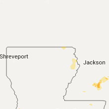


Cities Most Affected by Hail Storms of 8/10/2015
| Hail Size | Demographics of Zip Codes Affected | ||||||
|---|---|---|---|---|---|---|---|
| City | Count | Average | Largest | Pop Density | House Value | Income | Age |
| Richfield, WI | 1 | 1.75 | 1.75 | 169 | $195k | $71.0k | 43.3 |
Hail and Wind Damage Spotted on 8/10/2015
Filter by Report Type:Hail ReportsWind Reports
States Impacted
Wisconsin, Alabama, Kansas, Ohio, Colorado, Georgia, North Carolina, Tennessee, New York, Illinois, South Carolina, Virginia, Louisiana, Idaho, West Virginia, Mississippi, New Mexico, Montana, WashingtonWisconsin
| Local Time | Report Details |
|---|---|
| 11:25 AM CDT | Golf Ball sized hail reported near Richfield, WI, 63.6 miles E of Madison, WI, reported at the public work facility |
| 12:15 PM CDT | Quarter sized hail reported near Milwaukee, WI, 75.4 miles E of Madison, WI, a few blocks from south shore park in bay view |
| 3:55 PM CDT | Racine county law enforcement reported trees and power poles down in the union grove are in racine county WI, 59 miles NNW of Chicago, IL |
Alabama
| Local Time | Report Details |
|---|---|
| 12:15 PM CDT | A tree fell onto a power line causing the power to go out at a residence on cabbage patch road. time is radar estimate in morgan county AL, 61.1 miles ESE of Florence, AL |
| 12:30 PM CDT | Light pole blew down on shamrock drive. time is radar estimate in madison county AL, 59.5 miles E of Florence, AL |
| 12:34 PM CDT | Tree down on a house on windover drive. time is radar estimate in madison county AL, 63 miles E of Florence, AL |
| 2:08 PM CDT | Tree down on county line street near county road 16 in cherokee county AL, 61.6 miles SSW of Chattanooga, TN |
| 2:19 PM CDT | A tree and power line down and on fire near the highway 68 and county road 75 intersectio in cherokee county AL, 57.3 miles SSW of Chattanooga, TN |
| 2:20 PM CDT | Tree down on garmon road near oakwood driv in etowah county AL, 63 miles NE of Birmingham, AL |
| 3:40 PM CDT | Tree downed and some tin pulled off a shed roof near falkville in the vicinity of mile marker 322 on interstate 6 in morgan county AL, 53.3 miles ESE of Florence, AL |
| 6:30 PM CDT | Several trees reported down in downtown anniston. trees are blocking henry rd and crestview r in calhoun county AL, 59 miles E of Birmingham, AL |
| 6:30 PM CDT | Several trees down along county road 10 between alabama 17 and 9. damage to an outbuilding and car. also chimney damaged due to wind in sumter county AL, 59.8 miles WNW of Camden, AL |
| 8:05 PM CDT | Trees down in bagley are in jefferson county AL, 19.5 miles NNW of Birmingham, AL |
| 8:25 PM CDT | Tree down along alliance road. time estimated by rada in jefferson county AL, 17.6 miles WNW of Birmingham, AL |
| 8:40 PM CDT | Large tree down on 15th street road going into concor in jefferson county AL, 14.4 miles WSW of Birmingham, AL |
| 8:50 PM CDT | Tree down at saddlertown road s in jefferson county AL, 12.9 miles SW of Birmingham, AL |
| 9:10 PM CDT | Tree down on roy drive at jenkins circle in helen in shelby county AL, 16.7 miles S of Birmingham, AL |
| 9:20 PM CDT | Power lines down in southern hills subdivision off of highway 2 in shelby county AL, 25.6 miles S of Birmingham, AL |
| 9:25 PM CDT | Trees down along hwy 43... appling dr... and john swindle r in tuscaloosa county AL, 46.1 miles W of Birmingham, AL |
Kansas
| Local Time | Report Details |
|---|---|
| 12:22 PM CDT | Tree damage including large limbs down in eudor in douglas county KS, 30 miles WSW of Kansas City, MO |
Ohio
| Local Time | Report Details |
|---|---|
| 2:04 PM EDT | Several trees uprooted and snapped. time estimated from rada in licking county OH, 27.5 miles ENE of Columbus, OH |
| 9:22 PM EDT | Tree down on oh-7 in hubbard. time estimated via rada in trumbull county OH, 58.1 miles NNW of Pittsburgh, PA |
| 9:28 PM EDT | Tree reported down with some power lines in lowellville. time estimated via rada in mahoning county OH, 50.6 miles NW of Pittsburgh, PA |
Colorado
| Local Time | Report Details |
|---|---|
| 12:25 PM MDT | Quarter sized hail reported near Colorado Springs, CO, 45.3 miles NNW of Pueblo, CO |
| 3:22 PM MDT | Quarter sized hail reported near Walsh, CO, 100.8 miles WSW of Garden City, KS |
Georgia
| Local Time | Report Details |
|---|---|
| 2:25 PM EDT | Two trees down near dewy ros in elbert county GA, 50.9 miles SSW of Greenville, SC |
| 3:20 PM EDT | Trees reported down at a location on beaverdal road and school stree in madison county GA, 56 miles SW of Greenville, SC |
| 3:20 PM EDT | Trees reported down at a location on beaverdal road and school stree in whitfield county GA, 27.1 miles SE of Chattanooga, TN |
| 3:25 PM EDT | Trees were reported down on powerlines along smoke tree circle in boynto in catoosa county GA, 11 miles SE of Chattanooga, TN |
| 3:35 PM EDT | Trees down on tavern lane in trion and another on filter plant road near berryto in chattooga county GA, 34.9 miles S of Chattanooga, TN |
| 3:41 PM EDT | Tree reported down on powerlines along charolais trai in whitfield county GA, 21.2 miles ESE of Chattanooga, TN |
| 3:49 PM EDT | Amateur radio operator reported utility lines down at spring place symrna road near lenard bridge roa in murray county GA, 39.1 miles ESE of Chattanooga, TN |
| 3:49 PM EDT | The clarke county 911 center reported numerous trees and powerlines down with some damage to homes and businesses. time is based on radar estimate. additional details w in clarke county GA, 59.1 miles E of Atlanta, GA |
| 4:36 PM EDT | The dawson county emergency manager reported one tree down on hwy 52. the tree was blocking the highwa in dawson county GA, 55.8 miles N of Atlanta, GA |
| 4:39 PM EDT | The dawson county emergency manager reported three trees down in the east central portion of the county. one tree is down at each of the following locations...ga hwy 53 in dawson county GA, 47.6 miles NNE of Atlanta, GA |
| 4:43 PM EDT | The dawson county emergency manager reported multiple trees down near grover burt road and hwy 13 in dawson county GA, 52.1 miles NNE of Atlanta, GA |
| 4:50 PM EDT | Four trees down in the ball ground/waleska are in cherokee county GA, 38.8 miles N of Atlanta, GA |
| 5:09 PM EDT | Law enforcement reported three trees down in the cleveland area. one was down at each of the following locations...hwy 129 and hulsey road...green street and town creek in white county GA, 67.9 miles WSW of Greenville, SC |
| 5:09 PM EDT | The hall county emergency manager reported about a dozen trees down near murrayville. in addition...a tree fell on a mobile home on crystal lake driv in hall county GA, 52.4 miles NNE of Atlanta, GA |
| 5:13 PM EDT | The forsyth county emergency manager reported one tree down at a c smith road and hopewell roa in forsyth county GA, 43.5 miles NNE of Atlanta, GA |
| 5:17 PM EDT | Law enforcement reported a tree down at hwy 115 e and pless roa in white county GA, 64.8 miles WSW of Greenville, SC |
| 5:21 PM EDT | The morgan county 911 center reported numerous trees and powerlines down in the madision area. one tree fell on a home...causing damage to the structur in morgan county GA, 54.1 miles E of Atlanta, GA |
| 6:00 PM EDT | Habersham 911 reports multiple powerlines down and roof damage to the eoc in clarkesville. numerous trees down also reported throughout habersham count in habersham county GA, 54.5 miles WSW of Greenville, SC |
| 6:05 PM EDT | Trees and powerlines down on falls rd in toccoa in stephens county GA, 44.5 miles WSW of Greenville, SC |
| 6:15 PM EDT | Tree down in lavonia near lake hartwell. time estimated from rada in franklin county GA, 39.6 miles SW of Greenville, SC |
| 6:45 PM EDT | Hart 911 reports tree down in hartwel in hart county GA, 38.1 miles SSW of Greenville, SC |
North Carolina
| Local Time | Report Details |
|---|---|
| 3:05 PM EDT | At least 6 trees down on roadways in madison county mainly from near marshall north to along interstate 26 toward the tennessee lin in madison county NC, 60.3 miles SSW of Bristol, TN |
| 6:15 PM EDT | Fd reports large tree down across lindsay bebber r in alexander county NC, 51.8 miles NNW of Charlotte, NC |
Tennessee
| Local Time | Report Details |
|---|---|
| 3:38 PM EDT | Oak tree down just north of cleveland... t in bradley county TN, 26.5 miles ENE of Chattanooga, TN |
| 4:22 PM EDT | Couple trees down in tellico plain in monroe county TN, 46 miles SSW of Knoxville, TN |
| 4:35 PM EDT | Several trees down near loudon... t in loudon county TN, 29 miles WSW of Knoxville, TN |
| 5:05 PM EDT | Several trees down between happy valley and wallan in blount county TN, 16.9 miles SSE of Knoxville, TN |
| 5:28 PM EDT | Couple trees down near seymour... t in sevier county TN, 10.5 miles SE of Knoxville, TN |
| 5:30 PM EDT | A few trees dow in sevier county TN, 22.6 miles SE of Knoxville, TN |
New York
| Local Time | Report Details |
|---|---|
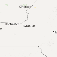
| 4:02 PM EDT | Tree dow in ontario county NY, 64.1 miles W of Syracuse, NY |
| 4:35 PM EDT | Quarter sized hail reported near Constable, NY, 60.7 miles ENE of Ogdensburg, NY |
| 5:13 PM EDT | Trees dow in wayne county NY, 44.7 miles W of Syracuse, NY |
| 5:29 PM EDT | Multiple tree reported dow in wayne county NY, 36.6 miles W of Syracuse, NY |
Illinois
| Local Time | Report Details |
|---|---|
| 3:39 PM CDT | Tree down on western ave and limbs down on fairview ave in dupage county IL, 22.1 miles W of Chicago, IL |
| 3:40 PM CDT | Trees branches down... 2-5 inch diameter at western and prairi in dupage county IL, 22.1 miles W of Chicago, IL |
| 4:08 PM CDT | 12 inch diameter tree down at lemont rd. and woodmere d in dupage county IL, 23.3 miles WSW of Chicago, IL |
South Carolina
| Local Time | Report Details |
|---|---|
| 4:45 PM EDT | Power lines reported down off long creek hwy at hobso in oconee county SC, 30 miles WSW of Greenville, SC |
| 4:50 PM EDT | Oconee county fd reported multiple trees down blocking the road at rochester hwy and doug hollow r in oconee county SC, 22.6 miles WSW of Greenville, SC |
| 6:44 PM EDT | Schp reports a tree down at hattons ford rd and pine cir. time estimated from rada in anderson county SC, 19.6 miles S of Greenville, SC |
| 6:54 PM EDT | Schp reports tree down on dobbins bridge rd in anderson county SC, 24.8 miles SSW of Greenville, SC |
Virginia
| Local Time | Report Details |
|---|---|
| 5:20 PM EDT | Several trees down in mt air in pittsylvania county VA, 47.2 miles ESE of Roanoke, VA |
Louisiana
| Local Time | Report Details |
|---|---|
| 4:35 PM CDT | Report of trees down near ball in rapides county LA, 85.9 miles NNW of Lafayette, LA |
Idaho
| Local Time | Report Details |
|---|---|
| 4:03 PM MDT | 61 mph gust recorded at the boise asos at 403 p in ada county ID, 1.9 miles W of Boise, ID |
| 4:07 PM MDT | Tree limbs down near overland and penninger road in ada county ID, 4.5 miles WSW of Boise, ID |
| 4:15 PM MDT | Vehicle damaged by fallen tre in ada county ID, 2.9 miles NW of Boise, ID |
| 4:15 PM MDT | Small tree limbs down in ada county ID, 3.1 miles WSW of Boise, ID |
| 4:27 PM MDT | 70 mph thunderstorm wind gust reported by publi in boise county ID, 20.9 miles N of Boise, ID |
| 5:04 PM MDT | Storm damage reported in lemhi county ID, 20.1 miles NW of Salmon, ID |
| 5:25 PM MDT | 58 mph thunderstorm wind gust at ts962 idarng3 d in elmore county ID, 35.7 miles SSE of Boise, ID |
| 8:45 PM PDT | A few power lines down. fire starts from the downed lines as well as lightning strikes. time estimated based on radar. hail was also reported but size was unknow in bonner county ID, 48.2 miles NE of Spokane, WA |
West Virginia
| Local Time | Report Details |
|---|---|
| 6:06 PM EDT | Tree down at intersection of low gap rd and park ave. reported by public via wvva. time radr estimate in mercer county WV, 64.3 miles W of Roanoke, VA |
Mississippi
| Local Time | Report Details |
|---|---|
| 5:47 PM CDT | Few trees down around raleig in smith county MS, 42.9 miles ESE of Jackson, MS |
| 6:30 PM CDT | Trees and power lines were dow in lawrence county MS, 40.9 miles SSE of Jackson, MS |
| 6:37 PM CDT | A roof was blown off of a she in lawrence county MS, 49.3 miles SSE of Jackson, MS |
| 6:40 PM CDT | Trees and power lines were dow in lawrence county MS, 51.8 miles S of Jackson, MS |
New Mexico
| Local Time | Report Details |
|---|---|
| 4:50 PM MDT | Quarter sized hail reported near Logan, NM, 20 miles NE of Tucumcari, NM |
Montana
| Local Time | Report Details |
|---|---|
| 5:00 PM MDT | Storm damage reported in ravalli county MT, 49.7 miles NNW of Salmon, ID |
| 5:25 PM MDT | Power lines and trees have been blown dow in ravalli county MT, 59.6 miles S of Missoula, MT |
| 6:39 PM MDT | Storm damage reported in missoula county MT, 5.5 miles NW of Missoula, MT |
| 7:14 PM MDT | Time of event is approximate in lake county MT, 20.2 miles N of Missoula, MT |
| 7:30 PM MDT | Tree damage and power lines down in the st ignatius area. time of event is estimate in lake county MT, 31.2 miles N of Missoula, MT |
| 7:49 PM MDT | 5 medium trees down. about 8 to 12 inches in diamete in missoula county MT, 2.1 miles W of Missoula, MT |
Washington
| Local Time | Report Details |
|---|---|
| 6:10 PM PDT | Alder ridge raws measured a 65 mph wind gust during the previous hou in garfield county WA, 42.7 miles ENE of Walla Walla, WA |
Connect with Interactive Hail Maps