

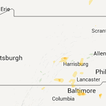
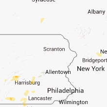
Hail Map for Tuesday, August 14, 2012

Number of Impacted Households on 8/14/2012
0
Impacted by 1" or Larger Hail
0
Impacted by 1.75" or Larger Hail
0
Impacted by 2.5" or Larger Hail
Square Miles of Populated Area Impacted on 8/14/2012
0
Impacted by 1" or Larger Hail
0
Impacted by 1.75" or Larger Hail
0
Impacted by 2.5" or Larger Hail


Cities Most Affected by Hail Storms of 8/14/2012
| Hail Size | Demographics of Zip Codes Affected | ||||||
|---|---|---|---|---|---|---|---|
| City | Count | Average | Largest | Pop Density | House Value | Income | Age |
Hail and Wind Damage Spotted on 8/14/2012
Filter by Report Type:Hail ReportsWind Reports
States Impacted
Virginia, Florida, Georgia, Maryland, West Virginia, North Carolina, Texas, Alabama, California, New York, Oklahoma, Montana, Pennsylvania, MassachusettsVirginia
| Local Time | Report Details |
|---|---|
| 3:00 PM EDT | Quarter sized hail reported near Bergton, VA, 48.3 miles E of Elkins, WV, very strong winds. |
| 5:08 PM EDT | Tree down across road and on power lines along 7000 block of hopkins gap rd west of harrisonburg...v in rockingham county VA, 53.7 miles ESE of Elkins, WV |
| 5:20 PM EDT | Tree down on simmers valley rdd in rockingham county VA, 62 miles ESE of Elkins, WV |
| 5:20 PM EDT | Tree down in rockingham county VA, 58.6 miles ESE of Elkins, WV |
| 5:29 PM EDT | Half Dollar sized hail reported near Luray, VA, 75.8 miles ESE of Elkins, WV |
| 7:08 PM EDT | Numerous trees uprooted...with 30 foot tall pine tree snappe in page county VA, 71.4 miles ESE of Elkins, WV |
| 7:10 PM EDT | Quarter sized hail reported near Rockbridge Baths, VA, 52.8 miles NNE of Roanoke, VA, dime to quarter size hail fell for close to 10 minutes along walkers creek road. |
| 7:13 PM EDT | Quarter sized hail reported near Rockbridge Baths, VA, 53.1 miles NNE of Roanoke, VA, dime to quarter size hail fell along anderson farm road for five to ten minutes. |
| 7:15 PM EDT | Quarter sized hail reported near Rockbridge Baths, VA, 53.7 miles NE of Roanoke, VA, quarter size hail was observed falling along anderson farm road for about 5 minutes. |
Florida
| Local Time | Report Details |
|---|---|
| 3:25 PM EDT | Off-duty nws employee reports a large tree down on san jose boulevard near the intersection of orange picker road in east mandarin. time of damage based on radar dat in duval county FL, 12.6 miles S of Jacksonville, FL |
Georgia
| Local Time | Report Details |
|---|---|
| 3:50 PM EDT | Several trees down in reynold in taylor county GA, 80.7 miles E of Auburn, AL |
| 3:50 PM EDT | Several trees were blown down...some on power lines...along highway 96 east of butler toward reynold in taylor county GA, 75.4 miles E of Auburn, AL |
| 4:30 PM EDT | Amateur radio operator relayed reports of several trees down across much of bibb count in bibb county GA, 78.7 miles SSE of Atlanta, GA |
| 4:40 PM EDT | Houston county ema relayed a report of two trees down in southern houston count in houston county GA, 80.4 miles NW of Douglas, GA |
| 4:50 PM EDT | Amateur radio operator relayed a report of several trees down over extreme southeast jones count in jones county GA, 79.7 miles SE of Atlanta, GA |
| 5:05 PM EDT | Large tree fell on a house on charlie floyd r in twiggs county GA, 83.2 miles NNW of Douglas, GA |
| 5:40 PM EDT | Numerous trees and power lines dow in wilkinson county GA, 79.4 miles SW of Augusta, GA |
| 5:57 PM EDT | Wmaz relayed a report of a barn destroyed along tennille-harrison roa in washington county GA, 65 miles SW of Augusta, GA |
| 6:00 PM EDT | Numerous trees down in the sandersville and tenille areas. areas south of tenille also affecte in washington county GA, 61 miles SW of Augusta, GA |
| 6:25 PM EDT | Several trees down and many large limbs down...some blocking u.s. hwy 22 in jefferson county GA, 48 miles SW of Augusta, GA |
| 6:30 PM EDT | Several trees were blown down in western glascock county along state highway 123 and county line road west. the trees were mostly rotte in glascock county GA, 46.9 miles WSW of Augusta, GA |
Maryland
| Local Time | Report Details |
|---|---|
| 4:19 PM EDT | Tree down across telephone lines near intersection of drake rd se and williams rd se in allegany county MD, 80 miles NE of Elkins, WV |
| 4:21 PM EDT | Multiple trees down on drake roa in allegany county MD, 80.5 miles NE of Elkins, WV |
| 7:04 PM EDT | Quarter sized hail reported near Westminster, MD, 31.5 miles NW of Baltimore, MD |
| 9:15 PM EDT | Tree down on west chesapeake ave at woodbine ave in baltimore county MD, 7.6 miles N of Baltimore, MD |
| 10:00 PM EDT | Ping Pong Ball sized hail reported near Parkville, MD, 6.9 miles NNE of Baltimore, MD, relayed via storm prediction center |
| 10:07 PM EDT | Quarter sized hail reported near Baltimore, MD, 5.8 miles NW of Baltimore, MD |
| 10:09 PM EDT | Quarter sized hail reported near Nottingham, MD, 9 miles NE of Baltimore, MD |
| 10:10 PM EDT | Quarter sized hail reported near Baltimore, MD, 6.1 miles NNW of Baltimore, MD |
| 10:14 PM EDT | Quarter sized hail reported near Rosedale, MD, 8.9 miles ENE of Baltimore, MD |
| 10:15 PM EDT | Tree down on west chesapeake ave at woodbine ave in baltimore county MD, 7.6 miles N of Baltimore, MD |
West Virginia
| Local Time | Report Details |
|---|---|
| 4:40 PM EDT | Quarter sized hail reported near Great Cacapon, WV, 89.4 miles SSW of State College, PA |
| 4:40 PM EDT | Quarter sized hail reported near Great Cacapon, WV, 88 miles SSW of State College, PA |
| 6:45 PM EDT | Tree knocked down across winchester ave near frenchys dr in hardy county WV, 48 miles ENE of Elkins, WV |
| 6:45 PM EDT | Tree limb down near intersection of north main st and williams s in hardy county WV, 48 miles ENE of Elkins, WV |
North Carolina
| Local Time | Report Details |
|---|---|
| 4:42 PM EDT | A tree was blown down on summer roa in henderson county NC, 39.9 miles NNE of Greenville, SC |
| 4:50 PM EDT | One small tree down just outside the reception area for brights creek golf and equestrian communit in polk county NC, 39.7 miles NNE of Greenville, SC |
| 11:20 PM EDT | Truck driver reported trees down on highway 158 between littleton and roanoke rapid in halifax county NC, 61.7 miles NE of Raleigh, NC |
Texas
| Local Time | Report Details |
|---|---|
| 4:00 PM CDT | Small outbuildings shifted on foundations. 1 camping trailer overturned. 1 camping trailer moved. fencing moved across roadwa in gray county TX, 53.1 miles ENE of Amarillo, TX |
| 4:22 PM CDT | Large tree limbs down...power line dow in gray county TX, 60.6 miles ENE of Amarillo, TX |
| 4:32 PM CDT | Large tree limbs down...power line dow in gray county TX, 60.6 miles ENE of Amarillo, TX |
| 4:32 PM CDT | 5 to 6 power poles snaped along interstate 40. interstate exit sign blown dow in gray county TX, 58.5 miles NNW of Childress, TX |
| 4:32 PM CDT | 5 to 6 power poles snapped along interstate 40. interstate exit sign blown dow in gray county TX, 58.5 miles NNW of Childress, TX |
| 4:35 PM CDT | Storm damage reported in gray county TX, 59.5 miles NNW of Childress, TX |
| 5:09 PM CDT | Storm damage reported in collingsworth county TX, 43 miles N of Childress, TX |
| 6:52 PM CDT | At kgyi in grayson county TX, 53 miles SSW of Atoka, OK |
| 7:08 PM CDT | Storm damage reported in grayson county TX, 50.1 miles SSW of Atoka, OK |
| 7:12 PM CDT | 62 mph winds reported near the intersection of hwy 91 and fm120 in grayson county TX, 50.1 miles SSW of Atoka, OK |
| 7:17 PM CDT | Estimated 55 to 60 mph in young county TX, 40.2 miles SSW of Wichita Falls, TX |
| 7:20 PM CDT | Several trees uprooted and homes with roof and porch damag in young county TX, 40.2 miles SSW of Wichita Falls, TX |
| 7:35 PM CDT | A silo was blown onto building in jacksboro. a gas station was also damage in jack county TX, 51.1 miles SSE of Wichita Falls, TX |
Alabama
| Local Time | Report Details |
|---|---|
| 4:10 PM CDT | 3 trees down around the city of new brockto in coffee county AL, 74 miles NNE of Miramar Beach, FL |
| 4:10 PM CDT | One large oak tree down on a house on railroad street in new brockto in coffee county AL, 74 miles NNE of Miramar Beach, FL |
| 4:32 PM CDT | Multiple trees reported down across the western portion of dale count in dale county AL, 80.6 miles S of Auburn, AL |
California
| Local Time | Report Details |
|---|---|
| 3:50 PM PDT | Runway 04 left wind speeds of 51 knots or 59 mp in kern county CA, 61.7 miles NNE of Los Angeles, CA |
| 4:05 PM PDT | Runway 023 wind speed of 52 knots or 60 mp in kern county CA, 61.7 miles NNE of Los Angeles, CA |
| 4:12 PM PDT | Runway 15 threshold wind speed of 58 knots or 67 mp in kern county CA, 61.7 miles NNE of Los Angeles, CA |
New York
| Local Time | Report Details |
|---|---|
| 8:05 PM EDT | Large branches down along route 392 in cortland county NY, 36.6 miles S of Syracuse, NY |
| 8:15 PM EDT | Numerous 6-12 inch branches down est 70-80 mph winds in cortland county NY, 36.6 miles S of Syracuse, NY |
| 8:20 PM EDT | Large tree blocking road on u.s. route 11 in cortland county NY, 34.6 miles S of Syracuse, NY |
| 8:25 PM EDT | Large tree blocking road on u.s. route 11 in cortland county NY, 36.6 miles S of Syracuse, NY |
| 8:25 PM EDT | Small wood power pole down est 70-80 mph wind in cortland county NY, 33.7 miles S of Syracuse, NY |
Oklahoma
| Local Time | Report Details |
|---|---|
| 7:25 PM CDT | Tree damage/large limbs in bryan county OK, 44.8 miles SW of Atoka, OK |
Montana
| Local Time | Report Details |
|---|---|
| 6:41 PM MDT | 67 mph wind gust at the cut bank airpor in glacier county MT, 90.9 miles E of Whitefish, MT |
| 6:42 PM MDT | Estimated 70 mph winds lifting dust and debris in glacier county MT, 90.9 miles NNW of Great Falls, MT |
| 6:44 PM MDT | 72 mph wind gust at the cut bank airpor in glacier county MT, 90.9 miles E of Whitefish, MT |
| 7:00 PM MDT | Large trees downed at rising sun campground... east side of glacier national par in glacier county MT, 38.9 miles NE of Whitefish, MT |
| 7:12 PM MDT | 58 mph wind gust at the dot sensor just east of east glacier par in glacier county MT, 52.8 miles E of Whitefish, MT |
| 7:20 PM MDT | Estimated wind gusts to 60 mph in the field in toole county MT, 67 miles N of Great Falls, MT |
| 7:29 PM MDT | 66 mph wind gust measured near brad in pondera county MT, 44.4 miles NW of Great Falls, MT |
| 8:00 PM MDT | 60 mph wind gus in teton county MT, 32.8 miles NNW of Great Falls, MT |
| 8:15 PM MDT | Estimated 65 mph in the augusta are in lewis and clark county MT, 50.8 miles W of Great Falls, MT |
| 8:20 PM MDT | 70 mph wind gus in cascade county MT, 24.7 miles SW of Great Falls, MT |
| 8:20 PM MDT | 70 mph wind gus in cascade county MT, 24.8 miles SW of Great Falls, MT |
| 8:23 PM MDT | 60 mph wind gust. power out at the nws office in great falls. visibility is 2 miles in blowing dus in cascade county MT, 4.3 miles SW of Great Falls, MT |
| 8:28 PM MDT | 62 mph wind gust at the nws office. power was out for a few minutes. blowing dus in cascade county MT, 4.8 miles SW of Great Falls, MT |
| 8:31 PM MDT | 58 mph wind gust at malmstrom af in cascade county MT, 5.9 miles E of Great Falls, MT |
| 8:35 PM MDT | 60 mph wind gust with cold front passag in cascade county MT, 27.4 miles SW of Great Falls, MT |
| 8:45 PM MDT | 3 inch tree limb broken off...and no powe in cascade county MT, 1.7 miles SE of Great Falls, MT |
| 8:50 PM MDT | 86 mph wind gust at millega in cascade county MT, 31.1 miles S of Great Falls, MT |
| 8:53 PM MDT | 62 mph wind gust just north of black eagl in cascade county MT, 1.8 miles NNE of Great Falls, MT |
| 9:45 PM MDT | Wind gust estimated near 60 mph. power was out for about 3 hour in meagher county MT, 60.5 miles N of Bozeman, MT |
| 10:13 PM MDT | 59 mph wind gust at the dot sensor near sieben flats on interstate 1 in lewis and clark county MT, 58.1 miles SW of Great Falls, MT |
Pennsylvania
| Local Time | Report Details |
|---|---|
| 9:15 PM EDT | Tree on house in mifflintown and numerous trees down in area surrounding mifflintown in juniata county PA, 28.7 miles ESE of State College, PA |
Massachusetts
| Local Time | Report Details |
|---|---|
| 5:36 AM EDT | Large tree limbs down on bear hole road and prospect stree in hampden county MA, 67 miles WNW of Providence, RI |
| 7:49 AM EDT | Eight inch diameter branch down on wooden fence on elm street in norfolk county MA, 18.3 miles NNE of Providence, RI |
Connect with Interactive Hail Maps