

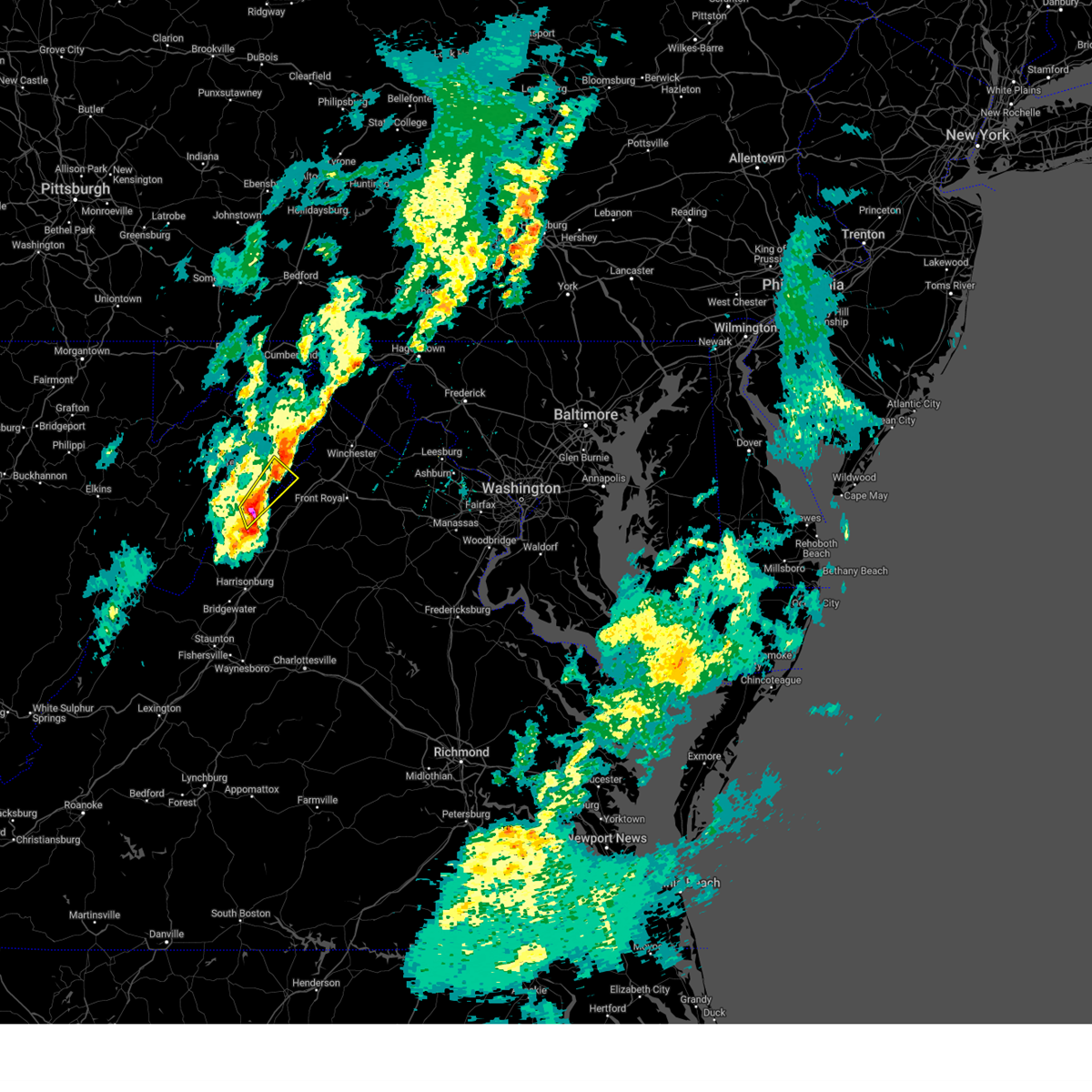
Hail Map for Basye, VA
The Basye, VA area has had 6 reports of on-the-ground hail by trained spotters, and has been under severe weather warnings 11 times during the past 12 months. Doppler radar has detected hail at or near Basye, VA on 30 occasions, including 1 occasion during the past year.
| Name: | Basye, VA |
| Where Located: | 59.1 miles E of Elkins, WV |
| Map: | Google Map for Basye, VA |
| Population: | 1253 |
| Housing Units: | 1646 |
| More Info: | Search Google for Basye, VA |
5
The Top Recent Hail Date for Basye, VA is Sunday, March 16, 2025 (1st out of 30)

Hail and Wind Damage Spotted near Basye, VA
| Date / Time | Report Details |
|---|---|
| 7/1/2025 2:38 PM EDT |
 Svrlwx the national weather service in sterling virginia has issued a * severe thunderstorm warning for, southern shenandoah county in northwestern virginia, central rockingham county in western virginia, southwestern warren county in northwestern virginia, page county in northwestern virginia, * until 330 pm edt. * at 238 pm edt, severe thunderstorms were located along a line extending from near mount jackson to timberville to 6 miles north of dale enterprise, moving east at 15 mph (radar indicated). Hazards include 60 mph wind gusts. Damaging winds will cause some trees and large branches to fall. this could injure those outdoors, as well as damage homes and vehicles. roadways may become blocked by downed trees. localized power outages are possible. Unsecured light objects may become projectiles. Svrlwx the national weather service in sterling virginia has issued a * severe thunderstorm warning for, southern shenandoah county in northwestern virginia, central rockingham county in western virginia, southwestern warren county in northwestern virginia, page county in northwestern virginia, * until 330 pm edt. * at 238 pm edt, severe thunderstorms were located along a line extending from near mount jackson to timberville to 6 miles north of dale enterprise, moving east at 15 mph (radar indicated). Hazards include 60 mph wind gusts. Damaging winds will cause some trees and large branches to fall. this could injure those outdoors, as well as damage homes and vehicles. roadways may become blocked by downed trees. localized power outages are possible. Unsecured light objects may become projectiles.
|
| 6/8/2025 7:40 PM EDT | At 739 pm edt, a severe thunderstorm was located near timberville, or 17 miles southwest of woodstock, moving east at 20 mph (radar indicated). Hazards include 60 mph wind gusts. Damaging winds will cause some trees and large branches to fall. this could injure those outdoors, as well as damage homes and vehicles. roadways may become blocked by downed trees. localized power outages are possible. unsecured light objects may become projectiles. Locations impacted include, alma, newport, honeyville, ingham, shenandoah caverns, leaksville, mount jackson, hamburg, quicksburg, hawkinstown, timberville, forestville, mount clifton, new market, luray, basye-bryce mountain, and basye. |
| 6/8/2025 7:29 PM EDT | Large tree fell onto powerlines at the 1800 block of north mountain rd in shenandoah county VA, 5.8 miles N of Basye, VA |
| 6/8/2025 7:14 PM EDT | Svrlwx the national weather service in sterling virginia has issued a * severe thunderstorm warning for, southwestern shenandoah county in northwestern virginia, northeastern rockingham county in western virginia, western page county in northwestern virginia, * until 815 pm edt. * at 714 pm edt, a severe thunderstorm was located 8 miles southwest of basye-bryce mountain, or 16 miles southeast of rough run, moving southeast at 20 mph (radar indicated). Hazards include 60 mph wind gusts. Damaging winds will cause some trees and large branches to fall. this could injure those outdoors, as well as damage homes and vehicles. roadways may become blocked by downed trees. localized power outages are possible. Unsecured light objects may become projectiles. |
| 3/16/2025 6:14 PM EDT |
 Svrlwx the national weather service in sterling virginia has issued a * severe thunderstorm warning for, central shenandoah county in northwestern virginia, southeastern hardy county in eastern west virginia, * until 630 pm edt. * at 614 pm edt, a severe thunderstorm was located over basye-bryce mountain, or 13 miles west of woodstock, moving northeast at 55 mph (radar indicated). Hazards include 60 mph wind gusts and quarter size hail. Damaging winds will cause some trees and large branches to fall. this could injure those outdoors, as well as damage homes and vehicles. roadways may become blocked by downed trees. localized power outages are possible. Unsecured light objects may become projectiles. Svrlwx the national weather service in sterling virginia has issued a * severe thunderstorm warning for, central shenandoah county in northwestern virginia, southeastern hardy county in eastern west virginia, * until 630 pm edt. * at 614 pm edt, a severe thunderstorm was located over basye-bryce mountain, or 13 miles west of woodstock, moving northeast at 55 mph (radar indicated). Hazards include 60 mph wind gusts and quarter size hail. Damaging winds will cause some trees and large branches to fall. this could injure those outdoors, as well as damage homes and vehicles. roadways may become blocked by downed trees. localized power outages are possible. Unsecured light objects may become projectiles.
|
| 3/16/2025 6:13 PM EDT |
 At 613 pm edt, a severe thunderstorm was located near mathias, or 14 miles southeast of moorefield, moving northeast at 55 mph (radar indicated). Hazards include 60 mph wind gusts and quarter size hail. Damaging winds will cause some trees and large branches to fall. this could injure those outdoors, as well as damage homes and vehicles. roadways may become blocked by downed trees. localized power outages are possible. unsecured light objects may become projectiles. Locations impacted include, orkney springs, perry, lost city, lost river, baker, mathias, jerome, mccauley, wardensville, basye, and basye-bryce mountain. At 613 pm edt, a severe thunderstorm was located near mathias, or 14 miles southeast of moorefield, moving northeast at 55 mph (radar indicated). Hazards include 60 mph wind gusts and quarter size hail. Damaging winds will cause some trees and large branches to fall. this could injure those outdoors, as well as damage homes and vehicles. roadways may become blocked by downed trees. localized power outages are possible. unsecured light objects may become projectiles. Locations impacted include, orkney springs, perry, lost city, lost river, baker, mathias, jerome, mccauley, wardensville, basye, and basye-bryce mountain.
|
| 3/16/2025 6:13 PM EDT |
 the severe thunderstorm warning has been cancelled and is no longer in effect the severe thunderstorm warning has been cancelled and is no longer in effect
|
| 3/16/2025 6:03 PM EDT |
 Svrlwx the national weather service in sterling virginia has issued a * severe thunderstorm warning for, northwestern shenandoah county in northwestern virginia, northern rockingham county in western virginia, central hardy county in eastern west virginia, * until 630 pm edt. * at 603 pm edt, a severe thunderstorm was located near mathias, or 12 miles southeast of rough run, moving northeast at 55 mph (radar indicated). Hazards include 60 mph wind gusts and quarter size hail. Damaging winds will cause some trees and large branches to fall. this could injure those outdoors, as well as damage homes and vehicles. roadways may become blocked by downed trees. localized power outages are possible. Unsecured light objects may become projectiles. Svrlwx the national weather service in sterling virginia has issued a * severe thunderstorm warning for, northwestern shenandoah county in northwestern virginia, northern rockingham county in western virginia, central hardy county in eastern west virginia, * until 630 pm edt. * at 603 pm edt, a severe thunderstorm was located near mathias, or 12 miles southeast of rough run, moving northeast at 55 mph (radar indicated). Hazards include 60 mph wind gusts and quarter size hail. Damaging winds will cause some trees and large branches to fall. this could injure those outdoors, as well as damage homes and vehicles. roadways may become blocked by downed trees. localized power outages are possible. Unsecured light objects may become projectiles.
|
| 7/17/2024 3:17 PM EDT |
 the severe thunderstorm warning has been cancelled and is no longer in effect the severe thunderstorm warning has been cancelled and is no longer in effect
|
| 7/17/2024 3:03 PM EDT |
 At 303 pm edt, a severe thunderstorm was located over mount jackson, or 13 miles southwest of woodstock, moving east at 30 mph (radar indicated). Hazards include 60 mph wind gusts and quarter size hail. Damaging winds will cause some trees and large branches to fall. this could injure those outdoors, as well as damage homes and vehicles. roadways may become blocked by downed trees. localized power outages are possible. unsecured light objects may become projectiles. Locations impacted include, woodstock, mount jackson, basye-bryce mountain, new market, basye, edinburg, maurertown, orkney springs, kings crossing, shenandoah caverns, harmony, alonzaville, quicksburg, saint davids church, hawkinstown, forestville, mount clifton, and jerome. At 303 pm edt, a severe thunderstorm was located over mount jackson, or 13 miles southwest of woodstock, moving east at 30 mph (radar indicated). Hazards include 60 mph wind gusts and quarter size hail. Damaging winds will cause some trees and large branches to fall. this could injure those outdoors, as well as damage homes and vehicles. roadways may become blocked by downed trees. localized power outages are possible. unsecured light objects may become projectiles. Locations impacted include, woodstock, mount jackson, basye-bryce mountain, new market, basye, edinburg, maurertown, orkney springs, kings crossing, shenandoah caverns, harmony, alonzaville, quicksburg, saint davids church, hawkinstown, forestville, mount clifton, and jerome.
|
| 7/17/2024 3:03 PM EDT |
 the severe thunderstorm warning has been cancelled and is no longer in effect the severe thunderstorm warning has been cancelled and is no longer in effect
|
| 7/17/2024 2:43 PM EDT |
 Svrlwx the national weather service in sterling virginia has issued a * severe thunderstorm warning for, shenandoah county in northwestern virginia, north central rockingham county in western virginia, northern page county in northwestern virginia, southern hardy county in eastern west virginia, * until 330 pm edt. * at 243 pm edt, a severe thunderstorm was located near timberville, or 17 miles north of harrisonburg, moving east at 30 mph (radar indicated). Hazards include 60 mph wind gusts and quarter size hail. Damaging winds will cause some trees and large branches to fall. this could injure those outdoors, as well as damage homes and vehicles. roadways may become blocked by downed trees. localized power outages are possible. Unsecured light objects may become projectiles. Svrlwx the national weather service in sterling virginia has issued a * severe thunderstorm warning for, shenandoah county in northwestern virginia, north central rockingham county in western virginia, northern page county in northwestern virginia, southern hardy county in eastern west virginia, * until 330 pm edt. * at 243 pm edt, a severe thunderstorm was located near timberville, or 17 miles north of harrisonburg, moving east at 30 mph (radar indicated). Hazards include 60 mph wind gusts and quarter size hail. Damaging winds will cause some trees and large branches to fall. this could injure those outdoors, as well as damage homes and vehicles. roadways may become blocked by downed trees. localized power outages are possible. Unsecured light objects may become projectiles.
|
| 5/26/2024 8:53 PM EDT |
 At 850 pm edt, severe thunderstorms were located along a line extending from mount davis to near westernport to moorefield to 6 miles southwest of mathias to near broadway, moving east at 35 mph. these storms have a history of storm damage including numerous trees reported down (radar indicated. impact...damaging winds will cause some trees and large branches to fall. this could injure those outdoors, as well as damage homes and vehicles. roadways may become blocked by downed trees. localized power outages are possible. unsecured light objects may become projectiles. locations impacted include, cumberland, frostburg, keyser, woodstock, westernport, romney, bel air, luray, la vale, timberville, shenandoah, mount jackson, stanley, fort ashby, lonaconing, piedmont, basye-bryce mountain, mathias, big meadows, and ridgeley). Hazards include 60 mph wind gusts and quarter size hail. At 850 pm edt, severe thunderstorms were located along a line extending from mount davis to near westernport to moorefield to 6 miles southwest of mathias to near broadway, moving east at 35 mph. these storms have a history of storm damage including numerous trees reported down (radar indicated. impact...damaging winds will cause some trees and large branches to fall. this could injure those outdoors, as well as damage homes and vehicles. roadways may become blocked by downed trees. localized power outages are possible. unsecured light objects may become projectiles. locations impacted include, cumberland, frostburg, keyser, woodstock, westernport, romney, bel air, luray, la vale, timberville, shenandoah, mount jackson, stanley, fort ashby, lonaconing, piedmont, basye-bryce mountain, mathias, big meadows, and ridgeley). Hazards include 60 mph wind gusts and quarter size hail.
|
| 5/26/2024 8:53 PM EDT |
 the severe thunderstorm warning has been cancelled and is no longer in effect the severe thunderstorm warning has been cancelled and is no longer in effect
|
| 5/26/2024 8:17 PM EDT |
 Svrlwx the national weather service in sterling virginia has issued a * severe thunderstorm warning for, northeastern garrett county in western maryland, western allegany county in western maryland, shenandoah county in northwestern virginia, southwestern rappahannock county in northwestern virginia, northwestern madison county in northwestern virginia, northeastern rockingham county in western virginia, page county in northwestern virginia, northwestern greene county in central virginia, eastern grant county in eastern west virginia, mineral county in eastern west virginia, east central pendleton county in eastern west virginia, hardy county in eastern west virginia, western hampshire county in eastern west virginia, * until 915 pm edt. * at 817 pm edt, severe thunderstorms were located along a line extending from friendsville to near deer park to 6 miles west of rough run to near brandywine to 13 miles west of dale enterprise, moving northeast at 35 mph (radar indicated). Hazards include 60 mph wind gusts and quarter size hail. Damaging winds will cause some trees and large branches to fall. this could injure those outdoors, as well as damage homes and vehicles. roadways may become blocked by downed trees. localized power outages are possible. Unsecured light objects may become projectiles. Svrlwx the national weather service in sterling virginia has issued a * severe thunderstorm warning for, northeastern garrett county in western maryland, western allegany county in western maryland, shenandoah county in northwestern virginia, southwestern rappahannock county in northwestern virginia, northwestern madison county in northwestern virginia, northeastern rockingham county in western virginia, page county in northwestern virginia, northwestern greene county in central virginia, eastern grant county in eastern west virginia, mineral county in eastern west virginia, east central pendleton county in eastern west virginia, hardy county in eastern west virginia, western hampshire county in eastern west virginia, * until 915 pm edt. * at 817 pm edt, severe thunderstorms were located along a line extending from friendsville to near deer park to 6 miles west of rough run to near brandywine to 13 miles west of dale enterprise, moving northeast at 35 mph (radar indicated). Hazards include 60 mph wind gusts and quarter size hail. Damaging winds will cause some trees and large branches to fall. this could injure those outdoors, as well as damage homes and vehicles. roadways may become blocked by downed trees. localized power outages are possible. Unsecured light objects may become projectiles.
|
| 9/8/2023 5:35 PM EDT |
 The severe thunderstorm warning for southwestern shenandoah, north central rockingham and south central hardy counties will expire at 545 pm edt, the storm which prompted the warning has weakened below severe limits, and no longer poses an immediate threat to life or property. therefore, the warning will be allowed to expire. however, small hail, gusty winds and heavy rain are still possible with this thunderstorm. a severe thunderstorm watch remains in effect until 1100 pm edt for western and northwestern virginia, and eastern west virginia. to report severe weather, contact your nearest law enforcement agency. they will relay your report to the national weather service sterling virginia. The severe thunderstorm warning for southwestern shenandoah, north central rockingham and south central hardy counties will expire at 545 pm edt, the storm which prompted the warning has weakened below severe limits, and no longer poses an immediate threat to life or property. therefore, the warning will be allowed to expire. however, small hail, gusty winds and heavy rain are still possible with this thunderstorm. a severe thunderstorm watch remains in effect until 1100 pm edt for western and northwestern virginia, and eastern west virginia. to report severe weather, contact your nearest law enforcement agency. they will relay your report to the national weather service sterling virginia.
|
| 9/8/2023 5:21 PM EDT |
 At 521 pm edt, a severe thunderstorm was located near basye-bryce mountain, or 16 miles southwest of woodstock, moving north at 15 mph (radar indicated). Hazards include 60 mph wind gusts and quarter size hail. Damaging winds will cause some trees and large branches to fall. this could injure those outdoors, as well as damage homes and vehicles. roadways may become blocked by downed trees. localized power outages are possible. unsecured light objects may become projectiles. locations impacted include, mathias, basye-bryce mountain, basye, orkney springs, jerome, and mount clifton. hail threat, radar indicated max hail size, 1. 00 in wind threat, radar indicated max wind gust, 60 mph. At 521 pm edt, a severe thunderstorm was located near basye-bryce mountain, or 16 miles southwest of woodstock, moving north at 15 mph (radar indicated). Hazards include 60 mph wind gusts and quarter size hail. Damaging winds will cause some trees and large branches to fall. this could injure those outdoors, as well as damage homes and vehicles. roadways may become blocked by downed trees. localized power outages are possible. unsecured light objects may become projectiles. locations impacted include, mathias, basye-bryce mountain, basye, orkney springs, jerome, and mount clifton. hail threat, radar indicated max hail size, 1. 00 in wind threat, radar indicated max wind gust, 60 mph.
|
| 9/8/2023 5:16 PM EDT |
 At 516 pm edt, a severe thunderstorm was located near basye-bryce mountain, or 17 miles southwest of woodstock, moving north at 15 mph (radar indicated). Hazards include 60 mph wind gusts and quarter size hail. Damaging winds will cause some trees and large branches to fall. this could injure those outdoors, as well as damage homes and vehicles. roadways may become blocked by downed trees. localized power outages are possible. Unsecured light objects may become projectiles. At 516 pm edt, a severe thunderstorm was located near basye-bryce mountain, or 17 miles southwest of woodstock, moving north at 15 mph (radar indicated). Hazards include 60 mph wind gusts and quarter size hail. Damaging winds will cause some trees and large branches to fall. this could injure those outdoors, as well as damage homes and vehicles. roadways may become blocked by downed trees. localized power outages are possible. Unsecured light objects may become projectiles.
|
| 9/6/2023 7:25 PM EDT |
 The severe thunderstorm warning for west central shenandoah, northern rockingham and south central hardy counties will expire at 730 pm edt, the storm which prompted the warning has weakened below severe limits, and no longer poses an immediate threat to life or property. therefore, the warning will be allowed to expire. to report severe weather, contact your nearest law enforcement agency. they will relay your report to the national weather service sterling virginia. The severe thunderstorm warning for west central shenandoah, northern rockingham and south central hardy counties will expire at 730 pm edt, the storm which prompted the warning has weakened below severe limits, and no longer poses an immediate threat to life or property. therefore, the warning will be allowed to expire. to report severe weather, contact your nearest law enforcement agency. they will relay your report to the national weather service sterling virginia.
|
| 9/6/2023 7:20 PM EDT | A tree was down in the bryce are in shenandoah county VA, 0.8 miles ENE of Basye, VA |
| 9/6/2023 7:03 PM EDT |
 At 702 pm edt, a severe thunderstorm was located over mathias, or 14 miles east of rough run, moving northeast at 10 mph (radar indicated). Hazards include 60 mph wind gusts. Damaging winds will cause some trees and large branches to fall. this could injure those outdoors, as well as damage homes and vehicles. roadways may become blocked by downed trees. localized power outages are possible. unsecured light objects may become projectiles. locations impacted include, basye-bryce mountain, mathias, basye, orkney springs, lost city, lost river, and jerome. hail threat, radar indicated max hail size, <. 75 in wind threat, radar indicated max wind gust, 60 mph. At 702 pm edt, a severe thunderstorm was located over mathias, or 14 miles east of rough run, moving northeast at 10 mph (radar indicated). Hazards include 60 mph wind gusts. Damaging winds will cause some trees and large branches to fall. this could injure those outdoors, as well as damage homes and vehicles. roadways may become blocked by downed trees. localized power outages are possible. unsecured light objects may become projectiles. locations impacted include, basye-bryce mountain, mathias, basye, orkney springs, lost city, lost river, and jerome. hail threat, radar indicated max hail size, <. 75 in wind threat, radar indicated max wind gust, 60 mph.
|
| 9/6/2023 7:01 PM EDT | Two trees were down along wv 259 near sawmill lan in hardy county WV, 7.5 miles ENE of Basye, VA |
| 9/6/2023 6:48 PM EDT |
 At 647 pm edt, a severe thunderstorm was located near mathias, or 13 miles east of rough run, moving northeast at 15 mph (radar indicated). Hazards include 60 mph wind gusts. Damaging winds will cause some trees and large branches to fall. this could injure those outdoors, as well as damage homes and vehicles. roadways may become blocked by downed trees. localized power outages are possible. Unsecured light objects may become projectiles. At 647 pm edt, a severe thunderstorm was located near mathias, or 13 miles east of rough run, moving northeast at 15 mph (radar indicated). Hazards include 60 mph wind gusts. Damaging winds will cause some trees and large branches to fall. this could injure those outdoors, as well as damage homes and vehicles. roadways may become blocked by downed trees. localized power outages are possible. Unsecured light objects may become projectiles.
|
| 8/7/2023 3:34 PM EDT |
 At 334 pm edt, a severe thunderstorm was located near broadway, or 13 miles north of harrisonburg, moving east at 25 mph (radar indicated). Hazards include 70 mph wind gusts and quarter size hail. Damaging winds will cause some trees and large branches to fall. this could injure those outdoors, as well as damage homes and vehicles. roadways may become blocked by downed trees. localized power outages are possible. unsecured light objects may become projectiles. locations impacted include, broadway, timberville, basye-bryce mountain, basye, tunis, yankeetown, cherry grove, lacey spring, fulks run, singers glen, rawley springs, linville, forestville and sparkling springs. thunderstorm damage threat, considerable hail threat, radar indicated max hail size, 1. 00 in wind threat, radar indicated max wind gust, 70 mph. At 334 pm edt, a severe thunderstorm was located near broadway, or 13 miles north of harrisonburg, moving east at 25 mph (radar indicated). Hazards include 70 mph wind gusts and quarter size hail. Damaging winds will cause some trees and large branches to fall. this could injure those outdoors, as well as damage homes and vehicles. roadways may become blocked by downed trees. localized power outages are possible. unsecured light objects may become projectiles. locations impacted include, broadway, timberville, basye-bryce mountain, basye, tunis, yankeetown, cherry grove, lacey spring, fulks run, singers glen, rawley springs, linville, forestville and sparkling springs. thunderstorm damage threat, considerable hail threat, radar indicated max hail size, 1. 00 in wind threat, radar indicated max wind gust, 70 mph.
|
| 8/7/2023 3:09 PM EDT |
 At 309 pm edt, a severe thunderstorm was located 8 miles east of brandywine, or 13 miles east of franklin, moving east at 45 mph (radar indicated). Hazards include 70 mph wind gusts and quarter size hail. Damaging winds will cause some trees and large branches to fall. this could injure those outdoors, as well as damage homes and vehicles. roadways may become blocked by downed trees. localized power outages are possible. unsecured light objects may become projectiles. locations impacted include, broadway, timberville, basye-bryce mountain, basye, tunis, yankeetown, cherry grove, lacey spring, fulks run, singers glen, rawley springs, linville, forestville and sparkling springs. thunderstorm damage threat, considerable hail threat, radar indicated max hail size, 1. 00 in wind threat, radar indicated max wind gust, 70 mph. At 309 pm edt, a severe thunderstorm was located 8 miles east of brandywine, or 13 miles east of franklin, moving east at 45 mph (radar indicated). Hazards include 70 mph wind gusts and quarter size hail. Damaging winds will cause some trees and large branches to fall. this could injure those outdoors, as well as damage homes and vehicles. roadways may become blocked by downed trees. localized power outages are possible. unsecured light objects may become projectiles. locations impacted include, broadway, timberville, basye-bryce mountain, basye, tunis, yankeetown, cherry grove, lacey spring, fulks run, singers glen, rawley springs, linville, forestville and sparkling springs. thunderstorm damage threat, considerable hail threat, radar indicated max hail size, 1. 00 in wind threat, radar indicated max wind gust, 70 mph.
|
| 8/7/2023 3:00 PM EDT |
 At 300 pm edt, a severe thunderstorm was located over brandywine, or 7 miles southeast of franklin, moving east at 45 mph (radar indicated). Hazards include 60 mph wind gusts and quarter size hail. Damaging winds will cause some trees and large branches to fall. this could injure those outdoors, as well as damage homes and vehicles. roadways may become blocked by downed trees. localized power outages are possible. Unsecured light objects may become projectiles. At 300 pm edt, a severe thunderstorm was located over brandywine, or 7 miles southeast of franklin, moving east at 45 mph (radar indicated). Hazards include 60 mph wind gusts and quarter size hail. Damaging winds will cause some trees and large branches to fall. this could injure those outdoors, as well as damage homes and vehicles. roadways may become blocked by downed trees. localized power outages are possible. Unsecured light objects may become projectiles.
|
| 7/1/2023 4:25 PM EDT | A couple trees down on mill gap road east of lost rive in hardy county WV, 9.4 miles S of Basye, VA |
| 7/1/2023 4:17 PM EDT |
 At 417 pm edt, severe thunderstorms were located along a line extending from near moorefield to 6 miles southwest of mathias, moving east at 30 mph (radar indicated). Hazards include 60 mph wind gusts and quarter size hail. Damaging winds will cause some trees and large branches to fall. this could injure those outdoors, as well as damage homes and vehicles. roadways may become blocked by downed trees. localized power outages are possible. unsecured light objects may become projectiles. locations impacted include, mount jackson, wardensville, basye-bryce mountain, mathias, basye, orkney springs, bean settlement, shenandoah caverns, bergton, perry, lost city, lost river, baker, mount clifton, inkerman, rio, jerome and mccauley. hail threat, radar indicated max hail size, 1. 00 in wind threat, radar indicated max wind gust, 60 mph. At 417 pm edt, severe thunderstorms were located along a line extending from near moorefield to 6 miles southwest of mathias, moving east at 30 mph (radar indicated). Hazards include 60 mph wind gusts and quarter size hail. Damaging winds will cause some trees and large branches to fall. this could injure those outdoors, as well as damage homes and vehicles. roadways may become blocked by downed trees. localized power outages are possible. unsecured light objects may become projectiles. locations impacted include, mount jackson, wardensville, basye-bryce mountain, mathias, basye, orkney springs, bean settlement, shenandoah caverns, bergton, perry, lost city, lost river, baker, mount clifton, inkerman, rio, jerome and mccauley. hail threat, radar indicated max hail size, 1. 00 in wind threat, radar indicated max wind gust, 60 mph.
|
| 7/1/2023 4:08 PM EDT |
 At 408 pm edt, severe thunderstorms were located along a line extending from near moorefield to 8 miles southeast of rough run, moving east at 30 mph (radar indicated). Hazards include 60 mph wind gusts and quarter size hail. Damaging winds will cause some trees and large branches to fall. this could injure those outdoors, as well as damage homes and vehicles. roadways may become blocked by downed trees. localized power outages are possible. unsecured light objects may become projectiles. locations impacted include, moorefield, mount jackson, wardensville, basye-bryce mountain, mathias, basye, orkney springs, bean settlement, shenandoah caverns, bergton, perry, lost city, lost river, baker, mount clifton, inkerman, rio, jerome and mccauley. hail threat, radar indicated max hail size, 1. 00 in wind threat, radar indicated max wind gust, 60 mph. At 408 pm edt, severe thunderstorms were located along a line extending from near moorefield to 8 miles southeast of rough run, moving east at 30 mph (radar indicated). Hazards include 60 mph wind gusts and quarter size hail. Damaging winds will cause some trees and large branches to fall. this could injure those outdoors, as well as damage homes and vehicles. roadways may become blocked by downed trees. localized power outages are possible. unsecured light objects may become projectiles. locations impacted include, moorefield, mount jackson, wardensville, basye-bryce mountain, mathias, basye, orkney springs, bean settlement, shenandoah caverns, bergton, perry, lost city, lost river, baker, mount clifton, inkerman, rio, jerome and mccauley. hail threat, radar indicated max hail size, 1. 00 in wind threat, radar indicated max wind gust, 60 mph.
|
| 7/1/2023 3:50 PM EDT |
 At 350 pm edt, severe thunderstorms were located along a line extending from near moorefield to 7 miles south of rough run, moving east at 30 mph (radar indicated). Hazards include 60 mph wind gusts and quarter size hail. Damaging winds will cause some trees and large branches to fall. this could injure those outdoors, as well as damage homes and vehicles. roadways may become blocked by downed trees. localized power outages are possible. Unsecured light objects may become projectiles. At 350 pm edt, severe thunderstorms were located along a line extending from near moorefield to 7 miles south of rough run, moving east at 30 mph (radar indicated). Hazards include 60 mph wind gusts and quarter size hail. Damaging winds will cause some trees and large branches to fall. this could injure those outdoors, as well as damage homes and vehicles. roadways may become blocked by downed trees. localized power outages are possible. Unsecured light objects may become projectiles.
|
| 11/30/2022 1:53 PM EST |
 The severe thunderstorm warning for north central washington county in north central maryland, shenandoah, frederick, northwestern warren and northwestern clarke counties in northwestern virginia, northwestern jefferson and central morgan counties in the panhandle of west virginia, southeastern hardy county in eastern west virginia, berkeley county in the panhandle of west virginia and southeastern hampshire counties in eastern west virginia and the city of winchester will expire at 200 pm est, the storms which prompted the warning have moved out of the area. therefore, the warning will be allowed to expire. however gusty winds are still possible with these thunderstorms. The severe thunderstorm warning for north central washington county in north central maryland, shenandoah, frederick, northwestern warren and northwestern clarke counties in northwestern virginia, northwestern jefferson and central morgan counties in the panhandle of west virginia, southeastern hardy county in eastern west virginia, berkeley county in the panhandle of west virginia and southeastern hampshire counties in eastern west virginia and the city of winchester will expire at 200 pm est, the storms which prompted the warning have moved out of the area. therefore, the warning will be allowed to expire. however gusty winds are still possible with these thunderstorms.
|
| 11/30/2022 1:15 PM EST |
 At 115 pm est, severe thunderstorms were located along a line extending from 7 miles southeast of berkeley springs to near star tannery to near mathias, moving east at 45 mph (radar indicated). Hazards include 60 mph wind gusts. Damaging winds will cause some trees and large branches to fall. this could injure those outdoors, as well as damage homes and vehicles. roadways may become blocked by downed trees. localized power outages are possible. Unsecured light objects may become projectiles. At 115 pm est, severe thunderstorms were located along a line extending from 7 miles southeast of berkeley springs to near star tannery to near mathias, moving east at 45 mph (radar indicated). Hazards include 60 mph wind gusts. Damaging winds will cause some trees and large branches to fall. this could injure those outdoors, as well as damage homes and vehicles. roadways may become blocked by downed trees. localized power outages are possible. Unsecured light objects may become projectiles.
|
| 6/26/2022 2:20 PM EDT | Several trees and wires were blown down bringing down 3 poles in lost rive in hardy county WV, 9.8 miles SSE of Basye, VA |
| 6/25/2022 7:24 PM EDT |
 The severe thunderstorm warning for west central shenandoah and central hardy counties will expire at 730 pm edt, the storm which prompted the warning has weakened below severe limits, and no longer poses an immediate threat to life or property. therefore, the warning will be allowed to expire. The severe thunderstorm warning for west central shenandoah and central hardy counties will expire at 730 pm edt, the storm which prompted the warning has weakened below severe limits, and no longer poses an immediate threat to life or property. therefore, the warning will be allowed to expire.
|
| 6/25/2022 7:10 PM EDT |
 At 710 pm edt, a severe thunderstorm was located near mathias, or 8 miles southeast of moorefield, moving east at 20 mph (radar indicated). Hazards include 60 mph wind gusts and quarter size hail. Damaging winds will cause some trees and large branches to fall. this could injure those outdoors, as well as damage homes and vehicles. roadways may become blocked by downed trees. localized power outages are possible. unsecured light objects may become projectiles. locations impacted include, basye-bryce mountain, basye, perry, lost city, jerome and lost river. hail threat, radar indicated max hail size, 1. 00 in wind threat, radar indicated max wind gust, 60 mph. At 710 pm edt, a severe thunderstorm was located near mathias, or 8 miles southeast of moorefield, moving east at 20 mph (radar indicated). Hazards include 60 mph wind gusts and quarter size hail. Damaging winds will cause some trees and large branches to fall. this could injure those outdoors, as well as damage homes and vehicles. roadways may become blocked by downed trees. localized power outages are possible. unsecured light objects may become projectiles. locations impacted include, basye-bryce mountain, basye, perry, lost city, jerome and lost river. hail threat, radar indicated max hail size, 1. 00 in wind threat, radar indicated max wind gust, 60 mph.
|
| 6/25/2022 6:48 PM EDT |
 At 648 pm edt, a severe thunderstorm was located near moorefield, moving southeast at 25 mph (radar indicated). Hazards include 60 mph wind gusts and quarter size hail. Damaging winds will cause some trees and large branches to fall. this could injure those outdoors, as well as damage homes and vehicles. roadways may become blocked by downed trees. localized power outages are possible. Unsecured light objects may become projectiles. At 648 pm edt, a severe thunderstorm was located near moorefield, moving southeast at 25 mph (radar indicated). Hazards include 60 mph wind gusts and quarter size hail. Damaging winds will cause some trees and large branches to fall. this could injure those outdoors, as well as damage homes and vehicles. roadways may become blocked by downed trees. localized power outages are possible. Unsecured light objects may become projectiles.
|
| 6/22/2022 8:37 PM EDT |
 The severe thunderstorm warning for west central shenandoah and central hardy counties will expire at 845 pm edt, the storm which prompted the warning has weakened below severe limits, and has exited the warned area. therefore, the warning will be allowed to expire. however gusty winds and heavy rain are still possible with this thunderstorm. a severe thunderstorm watch remains in effect until 900 pm edt for western and northwestern virginia, and eastern west virginia. The severe thunderstorm warning for west central shenandoah and central hardy counties will expire at 845 pm edt, the storm which prompted the warning has weakened below severe limits, and has exited the warned area. therefore, the warning will be allowed to expire. however gusty winds and heavy rain are still possible with this thunderstorm. a severe thunderstorm watch remains in effect until 900 pm edt for western and northwestern virginia, and eastern west virginia.
|
| 6/22/2022 8:19 PM EDT |
 At 819 pm edt, a severe thunderstorm was located near mathias, or 10 miles southeast of moorefield, moving southeast at 45 mph (radar indicated). Hazards include 60 mph wind gusts and quarter size hail. Damaging winds will cause some trees and large branches to fall. this could injure those outdoors, as well as damage homes and vehicles. roadways may become blocked by downed trees. localized power outages are possible. unsecured light objects may become projectiles. locations impacted include, woodstock, moorefield, basye-bryce mountain, mathias, basye, edinburg, orkney springs, harmony, perry, lost city, lost river, baker, mount clifton, jerome and mccauley. hail threat, radar indicated max hail size, 1. 00 in wind threat, radar indicated max wind gust, 60 mph. At 819 pm edt, a severe thunderstorm was located near mathias, or 10 miles southeast of moorefield, moving southeast at 45 mph (radar indicated). Hazards include 60 mph wind gusts and quarter size hail. Damaging winds will cause some trees and large branches to fall. this could injure those outdoors, as well as damage homes and vehicles. roadways may become blocked by downed trees. localized power outages are possible. unsecured light objects may become projectiles. locations impacted include, woodstock, moorefield, basye-bryce mountain, mathias, basye, edinburg, orkney springs, harmony, perry, lost city, lost river, baker, mount clifton, jerome and mccauley. hail threat, radar indicated max hail size, 1. 00 in wind threat, radar indicated max wind gust, 60 mph.
|
| 6/22/2022 8:02 PM EDT |
 At 801 pm edt, a severe thunderstorm was located near moorefield, moving southeast at 40 mph (radar indicated). Hazards include 60 mph wind gusts and quarter size hail. Damaging winds will cause some trees and large branches to fall. this could injure those outdoors, as well as damage homes and vehicles. roadways may become blocked by downed trees. localized power outages are possible. Unsecured light objects may become projectiles. At 801 pm edt, a severe thunderstorm was located near moorefield, moving southeast at 40 mph (radar indicated). Hazards include 60 mph wind gusts and quarter size hail. Damaging winds will cause some trees and large branches to fall. this could injure those outdoors, as well as damage homes and vehicles. roadways may become blocked by downed trees. localized power outages are possible. Unsecured light objects may become projectiles.
|
| 8/28/2021 6:52 PM EDT | Tree down on overly hollow road near bergton roa in rockingham county VA, 8.9 miles ENE of Basye, VA |
| 8/26/2021 4:15 PM EDT |
 At 415 pm edt, a severe thunderstorm was located near timberville, or 19 miles north of harrisonburg, moving north at 10 mph (radar indicated). Hazards include 60 mph wind gusts. Damaging winds will cause some trees and large branches to fall. this could injure those outdoors, as well as damage homes and vehicles. roadways may become blocked by downed trees. localized power outages are possible. unsecured light objects may become projectiles. locations impacted include, basye-bryce mountain, mathias, basye, tunis, orkney springs and mount clifton. hail threat, radar indicated max hail size, <. 75 in wind threat, radar indicated max wind gust, 60 mph. At 415 pm edt, a severe thunderstorm was located near timberville, or 19 miles north of harrisonburg, moving north at 10 mph (radar indicated). Hazards include 60 mph wind gusts. Damaging winds will cause some trees and large branches to fall. this could injure those outdoors, as well as damage homes and vehicles. roadways may become blocked by downed trees. localized power outages are possible. unsecured light objects may become projectiles. locations impacted include, basye-bryce mountain, mathias, basye, tunis, orkney springs and mount clifton. hail threat, radar indicated max hail size, <. 75 in wind threat, radar indicated max wind gust, 60 mph.
|
| 8/26/2021 4:02 PM EDT |
 At 402 pm edt, a severe thunderstorm was located near timberville, or 17 miles north of harrisonburg, moving north at 10 mph (radar indicated). Hazards include 60 mph wind gusts. Damaging winds will cause some trees and large branches to fall. this could injure those outdoors, as well as damage homes and vehicles. roadways may become blocked by downed trees. localized power outages are possible. Unsecured light objects may become projectiles. At 402 pm edt, a severe thunderstorm was located near timberville, or 17 miles north of harrisonburg, moving north at 10 mph (radar indicated). Hazards include 60 mph wind gusts. Damaging winds will cause some trees and large branches to fall. this could injure those outdoors, as well as damage homes and vehicles. roadways may become blocked by downed trees. localized power outages are possible. Unsecured light objects may become projectiles.
|
| 8/11/2021 3:20 PM EDT |
 The severe thunderstorm warning for northwestern shenandoah and central hardy counties will expire at 330 pm edt, the storms which prompted the warning have weakened below severe limits, and have exited the warned area. therefore, the warning will be allowed to expire. a severe thunderstorm watch remains in effect until 900 pm edt for northwestern virginia, and eastern west virginia. to report severe weather, contact your nearest law enforcement agency. they will relay your report to the national weather service sterling virginia. The severe thunderstorm warning for northwestern shenandoah and central hardy counties will expire at 330 pm edt, the storms which prompted the warning have weakened below severe limits, and have exited the warned area. therefore, the warning will be allowed to expire. a severe thunderstorm watch remains in effect until 900 pm edt for northwestern virginia, and eastern west virginia. to report severe weather, contact your nearest law enforcement agency. they will relay your report to the national weather service sterling virginia.
|
| 8/11/2021 3:00 PM EDT |
 At 300 pm edt, severe thunderstorms were located along a line extending from near moorefield to near basye-bryce mountain, moving east at 20 mph (radar indicated). Hazards include 60 mph wind gusts. Damaging winds will cause some trees and large branches to fall. this could injure those outdoors, as well as damage homes and vehicles. roadways may become blocked by downed trees. localized power outages are possible. unsecured light objects may become projectiles. locations impacted include, wardensville, basye-bryce mountain, basye, perry, bean settlement, lost city, lost river, baker, harmony, jerome and mccauley. hail threat, radar indicated max hail size, <. 75 in wind threat, radar indicated max wind gust, 60 mph. At 300 pm edt, severe thunderstorms were located along a line extending from near moorefield to near basye-bryce mountain, moving east at 20 mph (radar indicated). Hazards include 60 mph wind gusts. Damaging winds will cause some trees and large branches to fall. this could injure those outdoors, as well as damage homes and vehicles. roadways may become blocked by downed trees. localized power outages are possible. unsecured light objects may become projectiles. locations impacted include, wardensville, basye-bryce mountain, basye, perry, bean settlement, lost city, lost river, baker, harmony, jerome and mccauley. hail threat, radar indicated max hail size, <. 75 in wind threat, radar indicated max wind gust, 60 mph.
|
| 8/11/2021 2:44 PM EDT |
 At 244 pm edt, severe thunderstorms were located along a line extending from near moorefield to mathias, moving east at 20 mph (radar indicated). Hazards include 60 mph wind gusts. Damaging winds will cause some trees and large branches to fall. this could injure those outdoors, as well as damage homes and vehicles. roadways may become blocked by downed trees. localized power outages are possible. Unsecured light objects may become projectiles. At 244 pm edt, severe thunderstorms were located along a line extending from near moorefield to mathias, moving east at 20 mph (radar indicated). Hazards include 60 mph wind gusts. Damaging winds will cause some trees and large branches to fall. this could injure those outdoors, as well as damage homes and vehicles. roadways may become blocked by downed trees. localized power outages are possible. Unsecured light objects may become projectiles.
|
| 8/11/2021 2:36 PM EDT | A tree blew down near the intersection of va-820 bergton road and va-259 brocks gap roa in rockingham county VA, 10.3 miles ENE of Basye, VA |
| 7/7/2021 4:43 PM EDT |
 At 443 pm edt, a severe thunderstorm was located near basye-bryce mountain, or 16 miles southwest of woodstock, moving north at 15 mph (radar indicated). Hazards include 60 mph wind gusts and quarter size hail. Damaging winds will cause some trees and large branches to fall. this could injure those outdoors, as well as damage homes and vehicles. roadways may become blocked by downed trees. localized power outages are possible. unsecured light objects may become projectiles. Locations impacted include, basye-bryce mountain, mathias, basye, orkney springs, lost city, lost river, forestville, mount clifton and jerome. At 443 pm edt, a severe thunderstorm was located near basye-bryce mountain, or 16 miles southwest of woodstock, moving north at 15 mph (radar indicated). Hazards include 60 mph wind gusts and quarter size hail. Damaging winds will cause some trees and large branches to fall. this could injure those outdoors, as well as damage homes and vehicles. roadways may become blocked by downed trees. localized power outages are possible. unsecured light objects may become projectiles. Locations impacted include, basye-bryce mountain, mathias, basye, orkney springs, lost city, lost river, forestville, mount clifton and jerome.
|
| 7/7/2021 4:13 PM EDT |
 At 413 pm edt, a severe thunderstorm was located over timberville, or 13 miles north of harrisonburg, moving north at 15 mph (radar indicated). Hazards include 60 mph wind gusts and quarter size hail. Damaging winds will cause some trees and large branches to fall. this could injure those outdoors, as well as damage homes and vehicles. roadways may become blocked by downed trees. localized power outages are possible. Unsecured light objects may become projectiles. At 413 pm edt, a severe thunderstorm was located over timberville, or 13 miles north of harrisonburg, moving north at 15 mph (radar indicated). Hazards include 60 mph wind gusts and quarter size hail. Damaging winds will cause some trees and large branches to fall. this could injure those outdoors, as well as damage homes and vehicles. roadways may become blocked by downed trees. localized power outages are possible. Unsecured light objects may become projectiles.
|
| 7/6/2021 7:06 PM EDT |
 At 706 pm edt, a severe thunderstorm was located near basye-bryce mountain, or 17 miles southwest of woodstock, moving east at 20 mph (radar indicated). Hazards include 60 mph wind gusts. Damaging winds will cause some trees and large branches to fall. this could injure those outdoors, as well as damage homes and vehicles. roadways may become blocked by downed trees. localized power outages are possible. unsecured light objects may become projectiles. Locations impacted include, basye-bryce mountain, basye, orkney springs, forestville and mount clifton. At 706 pm edt, a severe thunderstorm was located near basye-bryce mountain, or 17 miles southwest of woodstock, moving east at 20 mph (radar indicated). Hazards include 60 mph wind gusts. Damaging winds will cause some trees and large branches to fall. this could injure those outdoors, as well as damage homes and vehicles. roadways may become blocked by downed trees. localized power outages are possible. unsecured light objects may become projectiles. Locations impacted include, basye-bryce mountain, basye, orkney springs, forestville and mount clifton.
|
| 7/6/2021 6:51 PM EDT |
 At 650 pm edt, a severe thunderstorm was located 8 miles southwest of basye-bryce mountain, or 17 miles southeast of rough run, moving east at 20 mph (public reported quarter size hail in bergton). Hazards include 60 mph wind gusts and half dollar size hail. Damaging winds will cause some trees and large branches to fall. this could injure those outdoors, as well as damage homes and vehicles. roadways may become blocked by downed trees. localized power outages are possible. unsecured light objects may become projectiles. Locations impacted include, basye-bryce mountain, basye, tunis, orkney springs, forestville and mount clifton. At 650 pm edt, a severe thunderstorm was located 8 miles southwest of basye-bryce mountain, or 17 miles southeast of rough run, moving east at 20 mph (public reported quarter size hail in bergton). Hazards include 60 mph wind gusts and half dollar size hail. Damaging winds will cause some trees and large branches to fall. this could injure those outdoors, as well as damage homes and vehicles. roadways may become blocked by downed trees. localized power outages are possible. unsecured light objects may become projectiles. Locations impacted include, basye-bryce mountain, basye, tunis, orkney springs, forestville and mount clifton.
|
| 7/6/2021 6:40 PM EDT |
 At 639 pm edt, a severe thunderstorm was located 10 miles northwest of broadway, or 15 miles southeast of rough run, moving east at 15 mph (radar indicated). Hazards include 60 mph wind gusts and quarter size hail. Damaging winds will cause some trees and large branches to fall. this could injure those outdoors, as well as damage homes and vehicles. roadways may become blocked by downed trees. localized power outages are possible. Unsecured light objects may become projectiles. At 639 pm edt, a severe thunderstorm was located 10 miles northwest of broadway, or 15 miles southeast of rough run, moving east at 15 mph (radar indicated). Hazards include 60 mph wind gusts and quarter size hail. Damaging winds will cause some trees and large branches to fall. this could injure those outdoors, as well as damage homes and vehicles. roadways may become blocked by downed trees. localized power outages are possible. Unsecured light objects may become projectiles.
|
| 7/6/2021 6:37 PM EDT | Quarter sized hail reported 13.2 miles ENE of Basye, VA |
| 6/30/2021 5:14 PM EDT |
 At 514 pm edt, a severe thunderstorm was located 7 miles northwest of timberville, or 18 miles southeast of rough run, moving northeast at 15 mph (radar indicated). Hazards include 60 mph wind gusts and quarter size hail. Damaging winds will cause some trees and large branches to fall. this could injure those outdoors, as well as damage homes and vehicles. roadways may become blocked by downed trees. localized power outages are possible. Unsecured light objects may become projectiles. At 514 pm edt, a severe thunderstorm was located 7 miles northwest of timberville, or 18 miles southeast of rough run, moving northeast at 15 mph (radar indicated). Hazards include 60 mph wind gusts and quarter size hail. Damaging winds will cause some trees and large branches to fall. this could injure those outdoors, as well as damage homes and vehicles. roadways may become blocked by downed trees. localized power outages are possible. Unsecured light objects may become projectiles.
|
| 5/4/2021 2:27 PM EDT |
 At 226 pm edt, a severe thunderstorm was located near basye-bryce mountain, or 18 miles southwest of woodstock, moving east at 30 mph (radar indicated). Hazards include 60 mph wind gusts and quarter size hail. Damaging winds will cause some trees and large branches to fall. this could injure those outdoors, as well as damage homes and vehicles. roadways may become blocked by downed trees. localized power outages are possible. Unsecured light objects may become projectiles. At 226 pm edt, a severe thunderstorm was located near basye-bryce mountain, or 18 miles southwest of woodstock, moving east at 30 mph (radar indicated). Hazards include 60 mph wind gusts and quarter size hail. Damaging winds will cause some trees and large branches to fall. this could injure those outdoors, as well as damage homes and vehicles. roadways may become blocked by downed trees. localized power outages are possible. Unsecured light objects may become projectiles.
|
| 5/4/2021 2:08 PM EDT |
 At 208 pm edt, a severe thunderstorm was located 11 miles southwest of mathias, or 14 miles southeast of rough run, moving east at 35 mph (radar indicated). Hazards include 60 mph wind gusts and quarter size hail. Damaging winds will cause some trees and large branches to fall. this could injure those outdoors, as well as damage homes and vehicles. roadways may become blocked by downed trees. localized power outages are possible. unsecured light objects may become projectiles. Locations impacted include, basye-bryce mountain, new market, basye, bergton, tunis, orkney springs, forestville, mount clifton, yankeetown, fulks run, criders and quicksburg. At 208 pm edt, a severe thunderstorm was located 11 miles southwest of mathias, or 14 miles southeast of rough run, moving east at 35 mph (radar indicated). Hazards include 60 mph wind gusts and quarter size hail. Damaging winds will cause some trees and large branches to fall. this could injure those outdoors, as well as damage homes and vehicles. roadways may become blocked by downed trees. localized power outages are possible. unsecured light objects may become projectiles. Locations impacted include, basye-bryce mountain, new market, basye, bergton, tunis, orkney springs, forestville, mount clifton, yankeetown, fulks run, criders and quicksburg.
|
| 5/4/2021 2:03 PM EDT |
 A severe thunderstorm warning remains in effect until 230 pm edt for west central shenandoah. north central rockingham. southern grant and southwestern hardy counties. at 203 pm edt, a severe thunderstorm was located 7 miles southeast of rough run, moving east at 30 mph. hazard. 60 mph wind gusts and quarter size hail. A severe thunderstorm warning remains in effect until 230 pm edt for west central shenandoah. north central rockingham. southern grant and southwestern hardy counties. at 203 pm edt, a severe thunderstorm was located 7 miles southeast of rough run, moving east at 30 mph. hazard. 60 mph wind gusts and quarter size hail.
|
| 5/4/2021 2:03 PM EDT |
 At 148 pm edt, a severe thunderstorm was located over rough run, moving east at 35 mph (radar indicated). Hazards include 60 mph wind gusts and quarter size hail. Damaging winds will cause some trees and large branches to fall. this could injure those outdoors, as well as damage homes and vehicles. roadways may become blocked by downed trees. localized power outages are possible. Unsecured light objects may become projectiles. At 148 pm edt, a severe thunderstorm was located over rough run, moving east at 35 mph (radar indicated). Hazards include 60 mph wind gusts and quarter size hail. Damaging winds will cause some trees and large branches to fall. this could injure those outdoors, as well as damage homes and vehicles. roadways may become blocked by downed trees. localized power outages are possible. Unsecured light objects may become projectiles.
|
| 5/4/2021 1:52 PM EDT |
 At 152 pm edt, a severe thunderstorm was located near brandywine, or 9 miles northeast of franklin, moving east at 35 mph (radar indicated). Hazards include 60 mph wind gusts and quarter size hail. Damaging winds will cause some trees and large branches to fall. this could injure those outdoors, as well as damage homes and vehicles. roadways may become blocked by downed trees. localized power outages are possible. Unsecured light objects may become projectiles. At 152 pm edt, a severe thunderstorm was located near brandywine, or 9 miles northeast of franklin, moving east at 35 mph (radar indicated). Hazards include 60 mph wind gusts and quarter size hail. Damaging winds will cause some trees and large branches to fall. this could injure those outdoors, as well as damage homes and vehicles. roadways may become blocked by downed trees. localized power outages are possible. Unsecured light objects may become projectiles.
|
| 5/4/2021 1:48 PM EDT |
 At 148 pm edt, a severe thunderstorm was located over rough run, moving east at 35 mph (radar indicated). Hazards include 60 mph wind gusts and quarter size hail. Damaging winds will cause some trees and large branches to fall. this could injure those outdoors, as well as damage homes and vehicles. roadways may become blocked by downed trees. localized power outages are possible. Unsecured light objects may become projectiles. At 148 pm edt, a severe thunderstorm was located over rough run, moving east at 35 mph (radar indicated). Hazards include 60 mph wind gusts and quarter size hail. Damaging winds will cause some trees and large branches to fall. this could injure those outdoors, as well as damage homes and vehicles. roadways may become blocked by downed trees. localized power outages are possible. Unsecured light objects may become projectiles.
|
| 11/15/2020 5:27 PM EST |
 At 526 pm est, severe thunderstorms were located along a line extending from near strasburg to 6 miles northeast of woodstock to near basye-bryce mountain, moving southeast at 25 mph (radar indicated). Hazards include 60 mph wind gusts. Damaging winds will cause some trees and large branches to fall. this could injure those outdoors, as well as damage homes and vehicles. roadways may become blocked by downed trees. localized power outages are possible. unsecured light objects may become projectiles. Locations impacted include, front royal, strasburg, woodstock, luray, mount jackson, stephens city, basye-bryce mountain, star tannery, new market, middletown, basye, edinburg, chester gap, maurertown, toms brook, alma, honeyville, shenandoah caverns, seven fountains and alonzaville. At 526 pm est, severe thunderstorms were located along a line extending from near strasburg to 6 miles northeast of woodstock to near basye-bryce mountain, moving southeast at 25 mph (radar indicated). Hazards include 60 mph wind gusts. Damaging winds will cause some trees and large branches to fall. this could injure those outdoors, as well as damage homes and vehicles. roadways may become blocked by downed trees. localized power outages are possible. unsecured light objects may become projectiles. Locations impacted include, front royal, strasburg, woodstock, luray, mount jackson, stephens city, basye-bryce mountain, star tannery, new market, middletown, basye, edinburg, chester gap, maurertown, toms brook, alma, honeyville, shenandoah caverns, seven fountains and alonzaville.
|
| 11/15/2020 5:00 PM EST |
 At 459 pm est, severe thunderstorms were located along a line extending from near star tannery to wardensville to 10 miles northeast of mathias, moving east at 25 mph (radar indicated). Hazards include 60 mph wind gusts. Damaging winds will cause some trees and large branches to fall. this could injure those outdoors, as well as damage homes and vehicles. roadways may become blocked by downed trees. localized power outages are possible. Unsecured light objects may become projectiles. At 459 pm est, severe thunderstorms were located along a line extending from near star tannery to wardensville to 10 miles northeast of mathias, moving east at 25 mph (radar indicated). Hazards include 60 mph wind gusts. Damaging winds will cause some trees and large branches to fall. this could injure those outdoors, as well as damage homes and vehicles. roadways may become blocked by downed trees. localized power outages are possible. Unsecured light objects may become projectiles.
|
| 7/21/2020 1:57 PM EDT |
 At 157 pm edt, a severe thunderstorm was located near basye-bryce mountain, or 15 miles southeast of rough run, moving east at 5 mph (radar indicated). Hazards include 60 mph wind gusts. Damaging winds will cause some trees and large branches to fall. this could injure those outdoors, as well as damage homes and vehicles. roadways may become blocked by downed trees. localized power outages are possible. unsecured light objects may become projectiles. Locations impacted include, basye-bryce mountain, basye and orkney springs. At 157 pm edt, a severe thunderstorm was located near basye-bryce mountain, or 15 miles southeast of rough run, moving east at 5 mph (radar indicated). Hazards include 60 mph wind gusts. Damaging winds will cause some trees and large branches to fall. this could injure those outdoors, as well as damage homes and vehicles. roadways may become blocked by downed trees. localized power outages are possible. unsecured light objects may become projectiles. Locations impacted include, basye-bryce mountain, basye and orkney springs.
|
| 7/21/2020 1:49 PM EDT |
 At 149 pm edt, a severe thunderstorm was located near mathias, or 14 miles southeast of rough run, moving east at 5 mph (radar indicated). Hazards include 70 mph wind gusts and quarter size hail. Damaging winds will cause some trees and large branches to fall. this could injure those outdoors, as well as damage homes and vehicles. roadways may become blocked by downed trees. localized power outages are possible. unsecured light objects may become projectiles. Locations impacted include, basye-bryce mountain, basye, bergton and orkney springs. At 149 pm edt, a severe thunderstorm was located near mathias, or 14 miles southeast of rough run, moving east at 5 mph (radar indicated). Hazards include 70 mph wind gusts and quarter size hail. Damaging winds will cause some trees and large branches to fall. this could injure those outdoors, as well as damage homes and vehicles. roadways may become blocked by downed trees. localized power outages are possible. unsecured light objects may become projectiles. Locations impacted include, basye-bryce mountain, basye, bergton and orkney springs.
|
| 7/21/2020 1:45 PM EDT | A few trees down north of broadwa in rockingham county VA, 10.3 miles ENE of Basye, VA |
| 7/21/2020 1:41 PM EDT |
 At 138 pm edt, a severe thunderstorm was located 7 miles south of mathias, or 13 miles southeast of rough run, moving east at 5 mph (radar indicated). Hazards include 60 mph wind gusts. Damaging winds will cause some trees and large branches to fall. this could injure those outdoors, as well as damage homes and vehicles. roadways may become blocked by downed trees. localized power outages are possible. Unsecured light objects may become projectiles. At 138 pm edt, a severe thunderstorm was located 7 miles south of mathias, or 13 miles southeast of rough run, moving east at 5 mph (radar indicated). Hazards include 60 mph wind gusts. Damaging winds will cause some trees and large branches to fall. this could injure those outdoors, as well as damage homes and vehicles. roadways may become blocked by downed trees. localized power outages are possible. Unsecured light objects may become projectiles.
|
| 7/21/2020 1:41 PM EDT |
 At 141 pm edt, a severe thunderstorm was located 7 miles south of mathias, or 14 miles southeast of rough run, moving east at 5 mph (radar indicated). Hazards include 60 mph wind gusts and quarter size hail. Damaging winds will cause some trees and large branches to fall. this could injure those outdoors, as well as damage homes and vehicles. roadways may become blocked by downed trees. localized power outages are possible. unsecured light objects may become projectiles. Locations impacted include, basye-bryce mountain, basye, bergton and orkney springs. At 141 pm edt, a severe thunderstorm was located 7 miles south of mathias, or 14 miles southeast of rough run, moving east at 5 mph (radar indicated). Hazards include 60 mph wind gusts and quarter size hail. Damaging winds will cause some trees and large branches to fall. this could injure those outdoors, as well as damage homes and vehicles. roadways may become blocked by downed trees. localized power outages are possible. unsecured light objects may become projectiles. Locations impacted include, basye-bryce mountain, basye, bergton and orkney springs.
|
| 7/21/2020 1:38 PM EDT |
 At 138 pm edt, a severe thunderstorm was located 7 miles south of mathias, or 13 miles southeast of rough run, moving east at 5 mph (radar indicated). Hazards include 60 mph wind gusts. Damaging winds will cause some trees and large branches to fall. this could injure those outdoors, as well as damage homes and vehicles. roadways may become blocked by downed trees. localized power outages are possible. Unsecured light objects may become projectiles. At 138 pm edt, a severe thunderstorm was located 7 miles south of mathias, or 13 miles southeast of rough run, moving east at 5 mph (radar indicated). Hazards include 60 mph wind gusts. Damaging winds will cause some trees and large branches to fall. this could injure those outdoors, as well as damage homes and vehicles. roadways may become blocked by downed trees. localized power outages are possible. Unsecured light objects may become projectiles.
|
| 6/22/2020 2:30 PM EDT |
 At 229 pm edt, a severe thunderstorm was located 8 miles southwest of wardensville, or 9 miles northwest of woodstock, moving northeast at 20 mph (radar indicated). Hazards include 60 mph wind gusts and quarter size hail. Damaging winds will cause some trees and large branches to fall. this could injure those outdoors, as well as damage homes and vehicles. roadways may become blocked by downed trees. localized power outages are possible. Unsecured light objects may become projectiles. At 229 pm edt, a severe thunderstorm was located 8 miles southwest of wardensville, or 9 miles northwest of woodstock, moving northeast at 20 mph (radar indicated). Hazards include 60 mph wind gusts and quarter size hail. Damaging winds will cause some trees and large branches to fall. this could injure those outdoors, as well as damage homes and vehicles. roadways may become blocked by downed trees. localized power outages are possible. Unsecured light objects may become projectiles.
|
| 6/4/2020 6:21 PM EDT |
 The severe thunderstorm warning for southwestern shenandoah, northwestern rockingham, east central pendleton and south central hardy counties will expire at 630 pm edt, the storm which prompted the warning has weakened below severe limits, and no longer poses an immediate threat to life or property. therefore, the warning will be allowed to expire. however gusty winds are still possible with this thunderstorm. a severe thunderstorm watch remains in effect until 1000 pm edt for western and northwestern virginia, and eastern west virginia. The severe thunderstorm warning for southwestern shenandoah, northwestern rockingham, east central pendleton and south central hardy counties will expire at 630 pm edt, the storm which prompted the warning has weakened below severe limits, and no longer poses an immediate threat to life or property. therefore, the warning will be allowed to expire. however gusty winds are still possible with this thunderstorm. a severe thunderstorm watch remains in effect until 1000 pm edt for western and northwestern virginia, and eastern west virginia.
|
| 6/4/2020 6:09 PM EDT |
 At 609 pm edt, a severe thunderstorm was located 10 miles northeast of brandywine, or 14 miles south of rough run, moving northeast at 30 mph (radar indicated). Hazards include 60 mph wind gusts. Damaging winds will cause some trees and large branches to fall. this could injure those outdoors, as well as damage homes and vehicles. roadways may become blocked by downed trees. localized power outages are possible. unsecured light objects may become projectiles. Locations impacted include, basye-bryce mountain, mathias, basye, bergton, tunis, orkney springs, forestville, yankeetown, fulks run and criders. At 609 pm edt, a severe thunderstorm was located 10 miles northeast of brandywine, or 14 miles south of rough run, moving northeast at 30 mph (radar indicated). Hazards include 60 mph wind gusts. Damaging winds will cause some trees and large branches to fall. this could injure those outdoors, as well as damage homes and vehicles. roadways may become blocked by downed trees. localized power outages are possible. unsecured light objects may become projectiles. Locations impacted include, basye-bryce mountain, mathias, basye, bergton, tunis, orkney springs, forestville, yankeetown, fulks run and criders.
|
| 6/4/2020 5:43 PM EDT |
 At 543 pm edt, a severe thunderstorm was located near brandywine, or 11 miles southeast of franklin, moving northeast at 30 mph (radar indicated). Hazards include 60 mph wind gusts and quarter size hail. Damaging winds will cause some trees and large branches to fall. this could injure those outdoors, as well as damage homes and vehicles. roadways may become blocked by downed trees. localized power outages are possible. Unsecured light objects may become projectiles. At 543 pm edt, a severe thunderstorm was located near brandywine, or 11 miles southeast of franklin, moving northeast at 30 mph (radar indicated). Hazards include 60 mph wind gusts and quarter size hail. Damaging winds will cause some trees and large branches to fall. this could injure those outdoors, as well as damage homes and vehicles. roadways may become blocked by downed trees. localized power outages are possible. Unsecured light objects may become projectiles.
|
| 5/29/2020 8:52 PM EDT |
 At 852 pm edt, a severe thunderstorm was located near basye-bryce mountain, or 9 miles west of woodstock, moving northeast at 40 mph (radar indicated). Hazards include quarter size hail. some hail damage to agriculture is expected At 852 pm edt, a severe thunderstorm was located near basye-bryce mountain, or 9 miles west of woodstock, moving northeast at 40 mph (radar indicated). Hazards include quarter size hail. some hail damage to agriculture is expected
|
| 3/3/2020 10:47 PM EST |
 At 1047 pm est, severe thunderstorms were located along a line extending from near wardensville to 7 miles south of rough run, moving southeast at 45 mph (trained weather spotters). Hazards include 60 mph wind gusts. Damaging winds will cause some trees and large branches to fall. this could injure those outdoors, as well as damage homes and vehicles. roadways may become blocked by downed trees. localized power outages are possible. unsecured light objects may become projectiles. Locations impacted include, winchester, front royal, strasburg, woodstock, millwood pike, berryville, broadway, timberville, mount jackson, stephens city, wardensville, basye-bryce mountain, mathias, star tannery, new market, middletown, basye, edinburg, maurertown and boyce. At 1047 pm est, severe thunderstorms were located along a line extending from near wardensville to 7 miles south of rough run, moving southeast at 45 mph (trained weather spotters). Hazards include 60 mph wind gusts. Damaging winds will cause some trees and large branches to fall. this could injure those outdoors, as well as damage homes and vehicles. roadways may become blocked by downed trees. localized power outages are possible. unsecured light objects may become projectiles. Locations impacted include, winchester, front royal, strasburg, woodstock, millwood pike, berryville, broadway, timberville, mount jackson, stephens city, wardensville, basye-bryce mountain, mathias, star tannery, new market, middletown, basye, edinburg, maurertown and boyce.
|
| 3/3/2020 10:28 PM EST |
 At 1028 pm est, severe thunderstorms were located along a line extending from 11 miles southwest of romney to 6 miles north of upper tract, moving southeast at 45 mph (trained weather spotters). Hazards include 60 mph wind gusts. Damaging winds will cause some trees and large branches to fall. this could injure those outdoors, as well as damage homes and vehicles. roadways may become blocked by downed trees. localized power outages are possible. Unsecured light objects may become projectiles. At 1028 pm est, severe thunderstorms were located along a line extending from 11 miles southwest of romney to 6 miles north of upper tract, moving southeast at 45 mph (trained weather spotters). Hazards include 60 mph wind gusts. Damaging winds will cause some trees and large branches to fall. this could injure those outdoors, as well as damage homes and vehicles. roadways may become blocked by downed trees. localized power outages are possible. Unsecured light objects may become projectiles.
|
| 8/20/2019 4:08 PM EDT |
 A severe thunderstorm warning remains in effect until 430 pm edt for central shenandoah and east central hardy counties. at 407 pm edt, severe thunderstorms were located along a line extending from 6 miles southwest of wardensville to near basye-bryce mountain, moving east at 20 mph. hazard. 60 mph wind gusts and quarter size hail. A severe thunderstorm warning remains in effect until 430 pm edt for central shenandoah and east central hardy counties. at 407 pm edt, severe thunderstorms were located along a line extending from 6 miles southwest of wardensville to near basye-bryce mountain, moving east at 20 mph. hazard. 60 mph wind gusts and quarter size hail.
|
| 8/20/2019 4:08 PM EDT |
 At 407 pm edt, severe thunderstorms were located along a line extending from 6 miles southwest of wardensville to near basye-bryce mountain, moving east at 20 mph (radar indicated. this storm has a history of producing wind damage to trees in hardy county). Hazards include 60 mph wind gusts and quarter size hail. Damaging winds will cause some trees and large branches to fall. this could injure those outdoors, as well as damage homes and vehicles. roadways may become blocked by downed trees. localized power outages are possible. unsecured light objects may become projectiles. Locations impacted include, woodstock, basye-bryce mountain, basye, edinburg, perry, harmony, alonzaville and jerome. At 407 pm edt, severe thunderstorms were located along a line extending from 6 miles southwest of wardensville to near basye-bryce mountain, moving east at 20 mph (radar indicated. this storm has a history of producing wind damage to trees in hardy county). Hazards include 60 mph wind gusts and quarter size hail. Damaging winds will cause some trees and large branches to fall. this could injure those outdoors, as well as damage homes and vehicles. roadways may become blocked by downed trees. localized power outages are possible. unsecured light objects may become projectiles. Locations impacted include, woodstock, basye-bryce mountain, basye, edinburg, perry, harmony, alonzaville and jerome.
|
| 8/20/2019 3:44 PM EDT |
 At 344 pm edt, severe thunderstorms were located along a line extending from 8 miles southeast of moorefield to near basye-bryce mountain, moving east at 15 mph (law enforcement has reported tree damage in hardy county). Hazards include 60 mph wind gusts. Damaging winds will cause some trees and large branches to fall. this could injure those outdoors, as well as damage homes and vehicles. roadways may become blocked by downed trees. localized power outages are possible. Unsecured light objects may become projectiles. At 344 pm edt, severe thunderstorms were located along a line extending from 8 miles southeast of moorefield to near basye-bryce mountain, moving east at 15 mph (law enforcement has reported tree damage in hardy county). Hazards include 60 mph wind gusts. Damaging winds will cause some trees and large branches to fall. this could injure those outdoors, as well as damage homes and vehicles. roadways may become blocked by downed trees. localized power outages are possible. Unsecured light objects may become projectiles.
|
| 8/18/2019 6:24 PM EDT | Multiple trees reported down on thorne bottom road near mill gap roa in hardy county WV, 10.1 miles S of Basye, VA |
| 7/30/2019 4:13 PM EDT |
 The severe thunderstorm warning for southwestern shenandoah county will expire at 415 pm edt, the storm which prompted the warning has weakened below severe limits, and no longer poses an immediate threat to life or property. therefore, the warning will be allowed to expire. to report severe weather, contact your nearest law enforcement agency. they will relay your report to the national weather service sterling virginia. remember, a severe thunderstorm warning still remains in effect for a different thunderstorm in eastern shenandoah county until 445 pm. The severe thunderstorm warning for southwestern shenandoah county will expire at 415 pm edt, the storm which prompted the warning has weakened below severe limits, and no longer poses an immediate threat to life or property. therefore, the warning will be allowed to expire. to report severe weather, contact your nearest law enforcement agency. they will relay your report to the national weather service sterling virginia. remember, a severe thunderstorm warning still remains in effect for a different thunderstorm in eastern shenandoah county until 445 pm.
|
| 7/30/2019 4:00 PM EDT |
 At 400 pm edt, a severe thunderstorm was located near basye-bryce mountain, or 17 miles southwest of woodstock, moving east at 15 mph (radar indicated). Hazards include 60 mph wind gusts. Damaging winds will cause some trees and large branches to fall. this could injure those outdoors, as well as damage homes and vehicles. roadways may become blocked by downed trees. localized power outages are possible. unsecured light objects may become projectiles. Locations impacted include, basye-bryce mountain, orkney springs, jerome, forestville and mount clifton. At 400 pm edt, a severe thunderstorm was located near basye-bryce mountain, or 17 miles southwest of woodstock, moving east at 15 mph (radar indicated). Hazards include 60 mph wind gusts. Damaging winds will cause some trees and large branches to fall. this could injure those outdoors, as well as damage homes and vehicles. roadways may become blocked by downed trees. localized power outages are possible. unsecured light objects may become projectiles. Locations impacted include, basye-bryce mountain, orkney springs, jerome, forestville and mount clifton.
|
| 7/30/2019 3:38 PM EDT |
 At 337 pm edt, a severe thunderstorm was located 10 miles south of mathias, or near criders, moving east at 10 mph (radar indicated). Hazards include 60 mph wind gusts and quarter size hail. Damaging winds will cause some trees and large branches to fall. this could injure those outdoors, as well as damage homes and vehicles. roadways may become blocked by downed trees. localized power outages are possible. Unsecured light objects may become projectiles. At 337 pm edt, a severe thunderstorm was located 10 miles south of mathias, or near criders, moving east at 10 mph (radar indicated). Hazards include 60 mph wind gusts and quarter size hail. Damaging winds will cause some trees and large branches to fall. this could injure those outdoors, as well as damage homes and vehicles. roadways may become blocked by downed trees. localized power outages are possible. Unsecured light objects may become projectiles.
|
| 7/11/2019 3:17 PM EDT |
 A severe thunderstorm warning remains in effect until 400 pm edt for southwestern shenandoah county. at 316 pm edt, a severe thunderstorm was located over basye-bryce mountain, or 15 miles southwest of woodstock. another severe thunderstorm was located near mount jackson. The storms are moving east at 15 mph. A severe thunderstorm warning remains in effect until 400 pm edt for southwestern shenandoah county. at 316 pm edt, a severe thunderstorm was located over basye-bryce mountain, or 15 miles southwest of woodstock. another severe thunderstorm was located near mount jackson. The storms are moving east at 15 mph.
|
| 7/11/2019 3:10 PM EDT |
 The national weather service in sterling virginia has issued a * severe thunderstorm warning for. southwestern shenandoah county in northwestern virginia. until 400 pm edt. At 310 pm edt, a severe thunderstorm was located near basye-bryce mountain, or 16 miles southwest of woodstock, moving east at 15. The national weather service in sterling virginia has issued a * severe thunderstorm warning for. southwestern shenandoah county in northwestern virginia. until 400 pm edt. At 310 pm edt, a severe thunderstorm was located near basye-bryce mountain, or 16 miles southwest of woodstock, moving east at 15.
|
| 4/19/2019 5:37 PM EDT |
 The severe thunderstorm warning for northwestern shenandoah, northwestern rockingham and central hardy counties will expire at 545 pm edt, the storm which prompted the warning has weakened below severe limits, and no longer poses an immediate threat to life or property. therefore, the warning will be allowed to expire. a tornado watch remains in effect until midnight edt for western and northwestern virginia, and eastern west virginia. The severe thunderstorm warning for northwestern shenandoah, northwestern rockingham and central hardy counties will expire at 545 pm edt, the storm which prompted the warning has weakened below severe limits, and no longer poses an immediate threat to life or property. therefore, the warning will be allowed to expire. a tornado watch remains in effect until midnight edt for western and northwestern virginia, and eastern west virginia.
|
| 4/19/2019 5:14 PM EDT |
 At 514 pm edt, a severe thunderstorm was located near mathias, or 10 miles east of rough run, moving northeast at 45 mph (radar indicated). Hazards include 60 mph wind gusts. Damaging winds will cause some trees and large branches to fall. this could injure those outdoors, as well as damage homes and vehicles. roadways may become blocked by downed trees. localized power outages are possible. unsecured light objects may become projectiles. Locations impacted include, wardensville, basye-bryce mountain, mathias, basye, orkney springs, yankeetown, bergton, perry, lost city, lost river, baker, jerome, criders and mccauley. At 514 pm edt, a severe thunderstorm was located near mathias, or 10 miles east of rough run, moving northeast at 45 mph (radar indicated). Hazards include 60 mph wind gusts. Damaging winds will cause some trees and large branches to fall. this could injure those outdoors, as well as damage homes and vehicles. roadways may become blocked by downed trees. localized power outages are possible. unsecured light objects may become projectiles. Locations impacted include, wardensville, basye-bryce mountain, mathias, basye, orkney springs, yankeetown, bergton, perry, lost city, lost river, baker, jerome, criders and mccauley.
|
| 4/19/2019 4:52 PM EDT |
 At 452 pm edt, a severe thunderstorm was located 8 miles northeast of brandywine, or 12 miles east of franklin, moving northeast at 45 mph (radar indicated). Hazards include 60 mph wind gusts. Damaging winds will cause some trees and large branches to fall. this could injure those outdoors, as well as damage homes and vehicles. roadways may become blocked by downed trees. localized power outages are possible. Unsecured light objects may become projectiles. At 452 pm edt, a severe thunderstorm was located 8 miles northeast of brandywine, or 12 miles east of franklin, moving northeast at 45 mph (radar indicated). Hazards include 60 mph wind gusts. Damaging winds will cause some trees and large branches to fall. this could injure those outdoors, as well as damage homes and vehicles. roadways may become blocked by downed trees. localized power outages are possible. Unsecured light objects may become projectiles.
|
| 4/14/2019 11:47 PM EDT |
 At 1146 pm edt, severe thunderstorms were located along a line extending from 7 miles west of wardensville to 7 miles west of broadway, moving east at 40 mph (radar indicated). Hazards include 60 mph wind gusts. Damaging winds will cause some trees and large branches to fall. this could injure those outdoors, as well as damage homes and vehicles. roadways may become blocked by downed trees. localized power outages are possible. unsecured light objects may become projectiles. Locations impacted include, broadway, wardensville, basye-bryce mountain, mathias, basye, tunis, orkney springs, harmony, yankeetown, cherry grove, alonzaville, singers glen, fulks run, bergton, perry, lost city, lost river, forestville, baker and mount clifton. At 1146 pm edt, severe thunderstorms were located along a line extending from 7 miles west of wardensville to 7 miles west of broadway, moving east at 40 mph (radar indicated). Hazards include 60 mph wind gusts. Damaging winds will cause some trees and large branches to fall. this could injure those outdoors, as well as damage homes and vehicles. roadways may become blocked by downed trees. localized power outages are possible. unsecured light objects may become projectiles. Locations impacted include, broadway, wardensville, basye-bryce mountain, mathias, basye, tunis, orkney springs, harmony, yankeetown, cherry grove, alonzaville, singers glen, fulks run, bergton, perry, lost city, lost river, forestville, baker and mount clifton.
|
| 4/14/2019 11:37 PM EDT |
 At 1136 pm edt, severe thunderstorms were located along a line extending from 8 miles west of wardensville to near bridgewater, moving east at 40 mph (radar indicated). Hazards include 60 mph wind gusts. Damaging winds will cause some trees and large branches to fall. this could injure those outdoors, as well as damage homes and vehicles. roadways may become blocked by downed trees. localized power outages are possible. unsecured light objects may become projectiles. Locations impacted include, broadway, wardensville, basye-bryce mountain, mathias, basye, tunis, yankeetown, alonzaville, bergton, perry, lost city, lost river, clover hill, baker, hinton, mccauley, orkney springs, harmony, cherry grove and singers glen. At 1136 pm edt, severe thunderstorms were located along a line extending from 8 miles west of wardensville to near bridgewater, moving east at 40 mph (radar indicated). Hazards include 60 mph wind gusts. Damaging winds will cause some trees and large branches to fall. this could injure those outdoors, as well as damage homes and vehicles. roadways may become blocked by downed trees. localized power outages are possible. unsecured light objects may become projectiles. Locations impacted include, broadway, wardensville, basye-bryce mountain, mathias, basye, tunis, yankeetown, alonzaville, bergton, perry, lost city, lost river, clover hill, baker, hinton, mccauley, orkney springs, harmony, cherry grove and singers glen.
|
| 4/14/2019 11:08 PM EDT |
 At 1107 pm edt, severe thunderstorms were located along a line extending from near petersburg to 13 miles southeast of monterey, moving east at 50 mph (radar indicated). Hazards include 60 mph wind gusts. Damaging winds will cause some trees and large branches to fall. this could injure those outdoors, as well as damage homes and vehicles. roadways may become blocked by downed trees. localized power outages are possible. Unsecured light objects may become projectiles. At 1107 pm edt, severe thunderstorms were located along a line extending from near petersburg to 13 miles southeast of monterey, moving east at 50 mph (radar indicated). Hazards include 60 mph wind gusts. Damaging winds will cause some trees and large branches to fall. this could injure those outdoors, as well as damage homes and vehicles. roadways may become blocked by downed trees. localized power outages are possible. Unsecured light objects may become projectiles.
|
| 8/17/2018 3:36 PM EDT |
 At 336 pm edt, a severe thunderstorm was located near mount jackson, or near woodstock, moving northeast at 25 mph (radar indicated). Hazards include 70 mph wind gusts. Damaging winds will cause some trees and large branches to fall. this could injure those outdoors, as well as damage homes and vehicles. roadways may become blocked by downed trees. localized power outages are possible. unsecured light objects may become projectiles. Locations impacted include, woodstock, mount jackson, basye-bryce mountain, basye, edinburg, kings crossing, shenandoah caverns, harmony, quicksburg, saint davids church, hawkinstown, forestville and mount clifton. At 336 pm edt, a severe thunderstorm was located near mount jackson, or near woodstock, moving northeast at 25 mph (radar indicated). Hazards include 70 mph wind gusts. Damaging winds will cause some trees and large branches to fall. this could injure those outdoors, as well as damage homes and vehicles. roadways may become blocked by downed trees. localized power outages are possible. unsecured light objects may become projectiles. Locations impacted include, woodstock, mount jackson, basye-bryce mountain, basye, edinburg, kings crossing, shenandoah caverns, harmony, quicksburg, saint davids church, hawkinstown, forestville and mount clifton.
|
| 8/17/2018 3:19 PM EDT |
 At 319 pm edt, a severe thunderstorm was located over basye-bryce mountain, or 13 miles southwest of woodstock, moving northeast at 25 mph (radar indicated). Hazards include golf ball size hail and 70 mph wind gusts. Expect wind damage to trees and power lines. hail is large enough to dent and damage vehicles. some hail damage to roofs, siding, and windows is possible. Locations impacted include, woodstock, mount jackson, basye-bryce mountain, basye, edinburg, orkney springs, kings crossing, shenandoah caverns, harmony, quicksburg, saint davids church, hawkinstown, forestville and mount clifton. At 319 pm edt, a severe thunderstorm was located over basye-bryce mountain, or 13 miles southwest of woodstock, moving northeast at 25 mph (radar indicated). Hazards include golf ball size hail and 70 mph wind gusts. Expect wind damage to trees and power lines. hail is large enough to dent and damage vehicles. some hail damage to roofs, siding, and windows is possible. Locations impacted include, woodstock, mount jackson, basye-bryce mountain, basye, edinburg, orkney springs, kings crossing, shenandoah caverns, harmony, quicksburg, saint davids church, hawkinstown, forestville and mount clifton.
|
| 8/17/2018 3:15 PM EDT |
 At 315 pm edt, a severe thunderstorm was located over basye-bryce mountain, or 15 miles southwest of woodstock, moving northeast at 25 mph (radar indicated). Hazards include 60 mph wind gusts and quarter size hail. Damaging winds will cause some trees and large branches to fall. this could injure those outdoors, as well as damage homes and vehicles. roadways may become blocked by downed trees. localized power outages are possible. Unsecured light objects may become projectiles. At 315 pm edt, a severe thunderstorm was located over basye-bryce mountain, or 15 miles southwest of woodstock, moving northeast at 25 mph (radar indicated). Hazards include 60 mph wind gusts and quarter size hail. Damaging winds will cause some trees and large branches to fall. this could injure those outdoors, as well as damage homes and vehicles. roadways may become blocked by downed trees. localized power outages are possible. Unsecured light objects may become projectiles.
|
| 8/17/2018 2:53 PM EDT |
 At 253 pm edt, severe thunderstorms were located along a line extending from near wardensville to near basye-bryce mountain, moving east at 20 mph (radar indicated). Hazards include 60 mph wind gusts. Damaging winds will cause some trees and large branches to fall. this could injure those outdoors, as well as damage homes and vehicles. roadways may become blocked by downed trees. localized power outages are possible. Unsecured light objects may become projectiles. At 253 pm edt, severe thunderstorms were located along a line extending from near wardensville to near basye-bryce mountain, moving east at 20 mph (radar indicated). Hazards include 60 mph wind gusts. Damaging winds will cause some trees and large branches to fall. this could injure those outdoors, as well as damage homes and vehicles. roadways may become blocked by downed trees. localized power outages are possible. Unsecured light objects may become projectiles.
|
| 7/4/2018 4:51 PM EDT |
 The severe thunderstorm warning for southwestern shenandoah and south central hardy counties will expire at 500 pm edt, the storm which prompted the warning has weakened below severe limits, and have exited the warned area. therefore the warning will be allowed to expire. however heavy rain is still possible with this thunderstorm. to report severe weather, contact your nearest law enforcement agency. they will relay your report to the national weather service sterling virginia. The severe thunderstorm warning for southwestern shenandoah and south central hardy counties will expire at 500 pm edt, the storm which prompted the warning has weakened below severe limits, and have exited the warned area. therefore the warning will be allowed to expire. however heavy rain is still possible with this thunderstorm. to report severe weather, contact your nearest law enforcement agency. they will relay your report to the national weather service sterling virginia.
|
| 7/4/2018 4:19 PM EDT |
 At 419 pm edt, a severe thunderstorm was located near basye-bryce mountain, or 11 miles west of woodstock, and is nearly stationary (radar indicated). Hazards include 60 mph wind gusts and quarter size hail. Damaging winds will cause some trees and large branches to fall. this could injure those outdoors, as well as damage homes and vehicles. roadways may become blocked by downed trees. localized power outages are possible. Unsecured light objects may become projectiles. At 419 pm edt, a severe thunderstorm was located near basye-bryce mountain, or 11 miles west of woodstock, and is nearly stationary (radar indicated). Hazards include 60 mph wind gusts and quarter size hail. Damaging winds will cause some trees and large branches to fall. this could injure those outdoors, as well as damage homes and vehicles. roadways may become blocked by downed trees. localized power outages are possible. Unsecured light objects may become projectiles.
|
| 6/9/2018 5:23 PM EDT |
 At 523 pm edt, a severe thunderstorm was located near basye-bryce mountain, or 11 miles west of woodstock, moving southeast at 25 mph (radar indicated). Hazards include 60 mph wind gusts and quarter size hail. Damaging winds will cause some trees and large branches to fall. this could injure those outdoors, as well as damage homes and vehicles. roadways may become blocked by downed trees. localized power outages are possible. Unsecured light objects may become projectiles. At 523 pm edt, a severe thunderstorm was located near basye-bryce mountain, or 11 miles west of woodstock, moving southeast at 25 mph (radar indicated). Hazards include 60 mph wind gusts and quarter size hail. Damaging winds will cause some trees and large branches to fall. this could injure those outdoors, as well as damage homes and vehicles. roadways may become blocked by downed trees. localized power outages are possible. Unsecured light objects may become projectiles.
|
| 8/11/2017 4:01 PM EDT |
 At 401 pm edt, a severe thunderstorm was located near woodstock, moving east at 20 mph (radar indicated). Hazards include 60 mph wind gusts and quarter size hail. Damaging winds will cause some trees and large branches to fall. this could injure those outdoors, as well as damage homes and vehicles. roadways may become blocked by downed trees. localized power outages are possible. Unsecured light objects may become projectiles. At 401 pm edt, a severe thunderstorm was located near woodstock, moving east at 20 mph (radar indicated). Hazards include 60 mph wind gusts and quarter size hail. Damaging winds will cause some trees and large branches to fall. this could injure those outdoors, as well as damage homes and vehicles. roadways may become blocked by downed trees. localized power outages are possible. Unsecured light objects may become projectiles.
|
| 8/4/2017 8:24 PM EDT |
 The severe thunderstorm warning for west central shenandoah and central hardy counties will expire at 830 pm edt, the storm which prompted the warning has weakened below severe limits, and no longer pose an immediate threat to life or property. therefore the warning will be allowed to expire. however gusty winds are still possible with this thunderstorm. The severe thunderstorm warning for west central shenandoah and central hardy counties will expire at 830 pm edt, the storm which prompted the warning has weakened below severe limits, and no longer pose an immediate threat to life or property. therefore the warning will be allowed to expire. however gusty winds are still possible with this thunderstorm.
|
| 8/4/2017 8:14 PM EDT |
 At 814 pm edt, a severe thunderstorm was located near mathias, or 14 miles west of woodstock, moving northeast at 35 mph (radar indicated). Hazards include 60 mph wind gusts and quarter size hail. Damaging winds will cause some trees and large branches to fall. this could injure those outdoors, as well as damage homes and vehicles. roadways may become blocked by downed trees. localized power outages are possible. unsecured light objects may become projectiles. Locations impacted include, basye-bryce mountain, mathias, basye, lost city, lost river, harmony and jerome. At 814 pm edt, a severe thunderstorm was located near mathias, or 14 miles west of woodstock, moving northeast at 35 mph (radar indicated). Hazards include 60 mph wind gusts and quarter size hail. Damaging winds will cause some trees and large branches to fall. this could injure those outdoors, as well as damage homes and vehicles. roadways may become blocked by downed trees. localized power outages are possible. unsecured light objects may become projectiles. Locations impacted include, basye-bryce mountain, mathias, basye, lost city, lost river, harmony and jerome.
|
| 8/4/2017 7:59 PM EDT |
 At 759 pm edt, a severe thunderstorm was located near mathias, or 13 miles southeast of rough run, moving northeast at 35 mph (radar indicated). Hazards include 60 mph wind gusts and quarter size hail. Damaging winds will cause some trees and large branches to fall. this could injure those outdoors, as well as damage homes and vehicles. roadways may become blocked by downed trees. localized power outages are possible. unsecured light objects may become projectiles. Locations impacted include, basye-bryce mountain, mathias, basye, bergton, orkney springs, lost city, lost river, harmony and jerome. At 759 pm edt, a severe thunderstorm was located near mathias, or 13 miles southeast of rough run, moving northeast at 35 mph (radar indicated). Hazards include 60 mph wind gusts and quarter size hail. Damaging winds will cause some trees and large branches to fall. this could injure those outdoors, as well as damage homes and vehicles. roadways may become blocked by downed trees. localized power outages are possible. unsecured light objects may become projectiles. Locations impacted include, basye-bryce mountain, mathias, basye, bergton, orkney springs, lost city, lost river, harmony and jerome.
|
| 8/4/2017 7:44 PM EDT |
 At 744 pm edt, a severe thunderstorm was located 12 miles northeast of brandywine, or 14 miles south of rough run, moving northeast at 35 mph (radar indicated). Hazards include 60 mph wind gusts and quarter size hail. Damaging winds will cause some trees and large branches to fall. this could injure those outdoors, as well as damage homes and vehicles. roadways may become blocked by downed trees. localized power outages are possible. Unsecured light objects may become projectiles. At 744 pm edt, a severe thunderstorm was located 12 miles northeast of brandywine, or 14 miles south of rough run, moving northeast at 35 mph (radar indicated). Hazards include 60 mph wind gusts and quarter size hail. Damaging winds will cause some trees and large branches to fall. this could injure those outdoors, as well as damage homes and vehicles. roadways may become blocked by downed trees. localized power outages are possible. Unsecured light objects may become projectiles.
|
| 7/21/2017 3:36 PM EDT |
 The severe thunderstorm warning for southern shenandoah, southeastern rockingham, page and northwestern rappahannock counties will expire at 345 pm edt, the storms which prompted the warning have weakened below severe limits, and no longer pose an immediate threat to life or property. therefore the warning will be allowed to expire. The severe thunderstorm warning for southern shenandoah, southeastern rockingham, page and northwestern rappahannock counties will expire at 345 pm edt, the storms which prompted the warning have weakened below severe limits, and no longer pose an immediate threat to life or property. therefore the warning will be allowed to expire.
|
| 7/21/2017 3:29 PM EDT |
 At 328 pm edt, severe thunderstorms were located along a line extending from near mount jackson to near stanley to near massanutten, moving east at 30 mph (radar indicated). Hazards include 60 mph wind gusts. Damaging winds will cause some trees and large branches to fall. this could injure those outdoors, as well as damage homes and vehicles. roadways may become blocked by downed trees. localized power outages are possible. unsecured light objects may become projectiles. Locations impacted include, luray, shenandoah, massanutten, mount jackson, stanley, big meadows, basye-bryce mountain, elkton, new market, basye, edinburg, newport, alma, honeyville, ingham, kings crossing, shenandoah caverns, leaksville, ida and hamburg. At 328 pm edt, severe thunderstorms were located along a line extending from near mount jackson to near stanley to near massanutten, moving east at 30 mph (radar indicated). Hazards include 60 mph wind gusts. Damaging winds will cause some trees and large branches to fall. this could injure those outdoors, as well as damage homes and vehicles. roadways may become blocked by downed trees. localized power outages are possible. unsecured light objects may become projectiles. Locations impacted include, luray, shenandoah, massanutten, mount jackson, stanley, big meadows, basye-bryce mountain, elkton, new market, basye, edinburg, newport, alma, honeyville, ingham, kings crossing, shenandoah caverns, leaksville, ida and hamburg.
|
| 7/21/2017 3:17 PM EDT |
 At 316 pm edt, severe thunderstorms were located along a line extending from near basye-bryce mountain to 6 miles east of timberville to near harrisonburg, moving east at 30 mph (radar indicated). Hazards include 60 mph wind gusts. Damaging winds will cause some trees and large branches to fall. this could injure those outdoors, as well as damage homes and vehicles. roadways may become blocked by downed trees. localized power outages are possible. unsecured light objects may become projectiles. Locations impacted include, harrisonburg, woodstock, luray, broadway, timberville, shenandoah, massanutten, mount jackson, stanley, basye-bryce mountain, big meadows, elkton, new market, basye, edinburg, newport, alma, honeyville, ingham and kings crossing. At 316 pm edt, severe thunderstorms were located along a line extending from near basye-bryce mountain to 6 miles east of timberville to near harrisonburg, moving east at 30 mph (radar indicated). Hazards include 60 mph wind gusts. Damaging winds will cause some trees and large branches to fall. this could injure those outdoors, as well as damage homes and vehicles. roadways may become blocked by downed trees. localized power outages are possible. unsecured light objects may become projectiles. Locations impacted include, harrisonburg, woodstock, luray, broadway, timberville, shenandoah, massanutten, mount jackson, stanley, basye-bryce mountain, big meadows, elkton, new market, basye, edinburg, newport, alma, honeyville, ingham and kings crossing.
|
| 7/21/2017 2:54 PM EDT |
 At 254 pm edt, severe thunderstorms were located along a line extending from near mathias to 6 miles northwest of broadway to dale enterprise, moving east at 25 mph (radar indicated). Hazards include 60 mph wind gusts. Damaging winds will cause some trees and large branches to fall. this could injure those outdoors, as well as damage homes and vehicles. roadways may become blocked by downed trees. localized power outages are possible. Unsecured light objects may become projectiles. At 254 pm edt, severe thunderstorms were located along a line extending from near mathias to 6 miles northwest of broadway to dale enterprise, moving east at 25 mph (radar indicated). Hazards include 60 mph wind gusts. Damaging winds will cause some trees and large branches to fall. this could injure those outdoors, as well as damage homes and vehicles. roadways may become blocked by downed trees. localized power outages are possible. Unsecured light objects may become projectiles.
|
| 3/1/2017 12:16 PM EST |
 At 1215 pm est, severe thunderstorms were located along a line extending from woodstock to near stuarts draft, moving east at 50 mph (radar indicated). Hazards include 60 mph wind gusts. Damaging winds will cause some trees and large branches to fall. this could injure those outdoors, as well as damage homes and vehicles. roadways may become blocked by downed trees. localized power outages are possible. unsecured light objects may become projectiles. Locations impacted include, harrisonburg, staunton, waynesboro, front royal, strasburg, woodstock, stuarts draft, bridgewater, crozet, luray, broadway, grottoes, timberville, shenandoah, massanutten, crimora, mount jackson, stanley, sherando and wintergreen. At 1215 pm est, severe thunderstorms were located along a line extending from woodstock to near stuarts draft, moving east at 50 mph (radar indicated). Hazards include 60 mph wind gusts. Damaging winds will cause some trees and large branches to fall. this could injure those outdoors, as well as damage homes and vehicles. roadways may become blocked by downed trees. localized power outages are possible. unsecured light objects may become projectiles. Locations impacted include, harrisonburg, staunton, waynesboro, front royal, strasburg, woodstock, stuarts draft, bridgewater, crozet, luray, broadway, grottoes, timberville, shenandoah, massanutten, crimora, mount jackson, stanley, sherando and wintergreen.
|
| 3/1/2017 12:08 PM EST |
 At 1208 pm est, severe thunderstorms were located along a line extending from near mathias to near bells valley, moving east at 50 mph (radar indicated). Hazards include 60 mph wind gusts. Damaging winds will cause some trees and large branches to fall. this could injure those outdoors, as well as damage homes and vehicles. roadways may become blocked by downed trees. localized power outages are possible. unsecured light objects may become projectiles. Locations impacted include, harrisonburg, staunton, waynesboro, front royal, strasburg, woodstock, stuarts draft, bridgewater, crozet, luray, broadway, grottoes, timberville, shenandoah, massanutten, crimora, mount jackson, stanley, sherando and wintergreen. At 1208 pm est, severe thunderstorms were located along a line extending from near mathias to near bells valley, moving east at 50 mph (radar indicated). Hazards include 60 mph wind gusts. Damaging winds will cause some trees and large branches to fall. this could injure those outdoors, as well as damage homes and vehicles. roadways may become blocked by downed trees. localized power outages are possible. unsecured light objects may become projectiles. Locations impacted include, harrisonburg, staunton, waynesboro, front royal, strasburg, woodstock, stuarts draft, bridgewater, crozet, luray, broadway, grottoes, timberville, shenandoah, massanutten, crimora, mount jackson, stanley, sherando and wintergreen.
|
| 3/1/2017 11:59 AM EST | Trees down in bergton in rockingham county VA, 11.2 miles ENE of Basye, VA |
| 3/1/2017 11:56 AM EST |
 At 1156 am est, severe thunderstorms were located along a line extending from near rough run to near yost, moving east at 50 mph (radar indicated). Hazards include 60 mph wind gusts. Damaging winds will cause some trees and large branches to fall. this could injure those outdoors, as well as damage homes and vehicles. roadways may become blocked by downed trees. localized power outages are possible. Unsecured light objects may become projectiles. At 1156 am est, severe thunderstorms were located along a line extending from near rough run to near yost, moving east at 50 mph (radar indicated). Hazards include 60 mph wind gusts. Damaging winds will cause some trees and large branches to fall. this could injure those outdoors, as well as damage homes and vehicles. roadways may become blocked by downed trees. localized power outages are possible. Unsecured light objects may become projectiles.
|
| 7/25/2016 3:43 PM EDT |
 At 342 pm edt, a severe thunderstorm was located 7 miles north of mount jackson, or 17 miles southwest of strasburg, moving east at 15 mph (radar indicated). Hazards include 60 mph wind gusts. Damaging winds will cause some trees and large branches to fall. this could injure those outdoors, as well as damage homes and vehicles. roadways may become blocked by downed trees. localized power outages are possible. unsecured light objects may become projectiles. Locations impacted include, strasburg, woodstock, edinburg, maurertown, toms brook, alonzaville, seven fountains, compton, harmony, saint davids church and dilbeck. At 342 pm edt, a severe thunderstorm was located 7 miles north of mount jackson, or 17 miles southwest of strasburg, moving east at 15 mph (radar indicated). Hazards include 60 mph wind gusts. Damaging winds will cause some trees and large branches to fall. this could injure those outdoors, as well as damage homes and vehicles. roadways may become blocked by downed trees. localized power outages are possible. unsecured light objects may become projectiles. Locations impacted include, strasburg, woodstock, edinburg, maurertown, toms brook, alonzaville, seven fountains, compton, harmony, saint davids church and dilbeck.
|
| 7/25/2016 3:33 PM EDT |
 At 333 pm edt, a severe thunderstorm was located near basye-bryce mountain, or 19 miles southwest of strasburg, moving east at 15 mph (radar indicated). Hazards include 60 mph wind gusts. Damaging winds will cause some trees and large branches to fall. this could injure those outdoors, as well as damage homes and vehicles. roadways may become blocked by downed trees. localized power outages are possible. Unsecured light objects may become projectiles. At 333 pm edt, a severe thunderstorm was located near basye-bryce mountain, or 19 miles southwest of strasburg, moving east at 15 mph (radar indicated). Hazards include 60 mph wind gusts. Damaging winds will cause some trees and large branches to fall. this could injure those outdoors, as well as damage homes and vehicles. roadways may become blocked by downed trees. localized power outages are possible. Unsecured light objects may become projectiles.
|
| 6/24/2016 5:36 PM EDT | Several trees down along howards lick rd in hardy county WV, 7.3 miles ESE of Basye, VA |
| 6/24/2016 5:36 PM EDT | Several trees down along crab run road in hardy county WV, 7 miles ESE of Basye, VA |
| 6/24/2016 5:31 PM EDT |
 At 530 pm edt, a severe thunderstorm was located over mathias, or 14 miles east of rough run, moving southeast at 20 mph (radar indicated). Hazards include 60 mph wind gusts and quarter size hail. Damaging winds will cause some trees and large branches to fall. this could injure those outdoors, as well as damage homes and vehicles. roadways may become blocked by downed trees. localized power outages are possible. unsecured light objects may become projectiles. Locations impacted include, basye-bryce mountain, mathias, basye, lost river, jerome, orkney springs and lost city. At 530 pm edt, a severe thunderstorm was located over mathias, or 14 miles east of rough run, moving southeast at 20 mph (radar indicated). Hazards include 60 mph wind gusts and quarter size hail. Damaging winds will cause some trees and large branches to fall. this could injure those outdoors, as well as damage homes and vehicles. roadways may become blocked by downed trees. localized power outages are possible. unsecured light objects may become projectiles. Locations impacted include, basye-bryce mountain, mathias, basye, lost river, jerome, orkney springs and lost city.
|
| 6/24/2016 5:05 PM EDT |
 At 505 pm edt, a severe thunderstorm was located near mathias, or 10 miles southeast of moorefield, moving southeast at 30 mph (radar indicated). Hazards include 60 mph wind gusts and quarter size hail. Damaging winds will cause some trees and large branches to fall. this could injure those outdoors, as well as damage homes and vehicles. roadways may become blocked by downed trees. localized power outages are possible. Unsecured light objects may become projectiles. At 505 pm edt, a severe thunderstorm was located near mathias, or 10 miles southeast of moorefield, moving southeast at 30 mph (radar indicated). Hazards include 60 mph wind gusts and quarter size hail. Damaging winds will cause some trees and large branches to fall. this could injure those outdoors, as well as damage homes and vehicles. roadways may become blocked by downed trees. localized power outages are possible. Unsecured light objects may become projectiles.
|
| 6/23/2016 3:55 PM EDT |
 At 355 pm edt, a severe thunderstorm was located 13 miles northwest of upper tract, or 14 miles south of davis, moving east at 55 mph (radar indicated). Hazards include 60 mph wind gusts and quarter size hail. Damaging winds will cause some trees and large branches to fall. this could injure those outdoors, as well as damage homes and vehicles. roadways may become blocked by downed trees. localized power outages are possible. Unsecured light objects may become projectiles. At 355 pm edt, a severe thunderstorm was located 13 miles northwest of upper tract, or 14 miles south of davis, moving east at 55 mph (radar indicated). Hazards include 60 mph wind gusts and quarter size hail. Damaging winds will cause some trees and large branches to fall. this could injure those outdoors, as well as damage homes and vehicles. roadways may become blocked by downed trees. localized power outages are possible. Unsecured light objects may become projectiles.
|
| 6/21/2016 4:23 PM EDT |
 The severe thunderstorm warning for central page, northeastern rockingham and southwestern shenandoah counties will expire at 430 pm edt, the storm which prompted the warning has moved out of the area. therefore the warning will be allowed to expire. a severe thunderstorm watch remains in effect until 900 pm edt for northwestern virginia. The severe thunderstorm warning for central page, northeastern rockingham and southwestern shenandoah counties will expire at 430 pm edt, the storm which prompted the warning has moved out of the area. therefore the warning will be allowed to expire. a severe thunderstorm watch remains in effect until 900 pm edt for northwestern virginia.
|
| 6/21/2016 4:09 PM EDT |
 At 408 pm edt, a severe thunderstorm was located near mount jackson, or 21 miles north of harrisonburg, moving southeast at 25 mph (radar indicated). Hazards include 60 mph wind gusts and half dollar size hail. Damaging winds will cause some trees and large branches to fall. this could injure those outdoors, as well as damage homes and vehicles. roadways may become blocked by downed trees. localized power outages are possible. unsecured light objects may become projectiles. Locations impacted include, luray, timberville, mount jackson, stanley, basye-bryce mountain, new market, basye, leaksville, kings crossing, quicksburg, hamburg, honeyville, forestville, newport, rileyville, hawkinstown, mount clifton, shenandoah caverns, ingham and alma. At 408 pm edt, a severe thunderstorm was located near mount jackson, or 21 miles north of harrisonburg, moving southeast at 25 mph (radar indicated). Hazards include 60 mph wind gusts and half dollar size hail. Damaging winds will cause some trees and large branches to fall. this could injure those outdoors, as well as damage homes and vehicles. roadways may become blocked by downed trees. localized power outages are possible. unsecured light objects may become projectiles. Locations impacted include, luray, timberville, mount jackson, stanley, basye-bryce mountain, new market, basye, leaksville, kings crossing, quicksburg, hamburg, honeyville, forestville, newport, rileyville, hawkinstown, mount clifton, shenandoah caverns, ingham and alma.
|
| 6/21/2016 3:51 PM EDT |
 At 350 pm edt, a severe thunderstorm was located near basye-bryce mountain, or 15 miles southeast of rough run, moving southeast at 20 mph (radar indicated). Hazards include 60 mph wind gusts and quarter size hail. Damaging winds will cause some trees and large branches to fall. this could injure those outdoors, as well as damage homes and vehicles. roadways may become blocked by downed trees. localized power outages are possible. Unsecured light objects may become projectiles. At 350 pm edt, a severe thunderstorm was located near basye-bryce mountain, or 15 miles southeast of rough run, moving southeast at 20 mph (radar indicated). Hazards include 60 mph wind gusts and quarter size hail. Damaging winds will cause some trees and large branches to fall. this could injure those outdoors, as well as damage homes and vehicles. roadways may become blocked by downed trees. localized power outages are possible. Unsecured light objects may become projectiles.
|
| 6/21/2016 2:02 PM EDT |
 At 202 pm edt, a severe thunderstorm was located near basye-bryce mountain, or 22 miles north of harrisonburg, moving east at 30 mph (radar indicated). Hazards include 60 mph wind gusts and quarter size hail. Damaging winds will cause some trees and large branches to fall. this could injure those outdoors, as well as damage homes and vehicles. roadways may become blocked by downed trees. localized power outages are possible. Unsecured light objects may become projectiles. At 202 pm edt, a severe thunderstorm was located near basye-bryce mountain, or 22 miles north of harrisonburg, moving east at 30 mph (radar indicated). Hazards include 60 mph wind gusts and quarter size hail. Damaging winds will cause some trees and large branches to fall. this could injure those outdoors, as well as damage homes and vehicles. roadways may become blocked by downed trees. localized power outages are possible. Unsecured light objects may become projectiles.
|
| 6/16/2016 7:22 PM EDT |
 At 722 pm edt, severe thunderstorms were located along a line extending from 7 miles southeast of wardensville to near broadway to 12 miles west of staunton, moving east at 45 mph (radar indicated). Hazards include 60 mph wind gusts and quarter size hail. Damaging winds will cause some trees and large branches to fall. this could injure those outdoors, as well as damage homes and vehicles. roadways may become blocked by downed trees. localized power outages are possible. unsecured light objects may become projectiles. Locations impacted include, harrisonburg, staunton, waynesboro, stuarts draft, bridgewater, luray, broadway, grottoes, timberville, shenandoah, massanutten, crimora, mount jackson, stanley, dale enterprise, big meadows, basye-bryce mountain, fishersville, woodstock and verona. At 722 pm edt, severe thunderstorms were located along a line extending from 7 miles southeast of wardensville to near broadway to 12 miles west of staunton, moving east at 45 mph (radar indicated). Hazards include 60 mph wind gusts and quarter size hail. Damaging winds will cause some trees and large branches to fall. this could injure those outdoors, as well as damage homes and vehicles. roadways may become blocked by downed trees. localized power outages are possible. unsecured light objects may become projectiles. Locations impacted include, harrisonburg, staunton, waynesboro, stuarts draft, bridgewater, luray, broadway, grottoes, timberville, shenandoah, massanutten, crimora, mount jackson, stanley, dale enterprise, big meadows, basye-bryce mountain, fishersville, woodstock and verona.
|
| 6/16/2016 6:55 PM EDT |
 At 654 pm edt, severe thunderstorms were located along a line extending from 6 miles east of moorefield to near brandywine to 6 miles northeast of burnsville, moving east at 45 mph (radar indicated). Hazards include 60 mph wind gusts and quarter size hail. Damaging winds will cause some trees and large branches to fall. this could injure those outdoors, as well as damage homes and vehicles. roadways may become blocked by downed trees. localized power outages are possible. Unsecured light objects may become projectiles. At 654 pm edt, severe thunderstorms were located along a line extending from 6 miles east of moorefield to near brandywine to 6 miles northeast of burnsville, moving east at 45 mph (radar indicated). Hazards include 60 mph wind gusts and quarter size hail. Damaging winds will cause some trees and large branches to fall. this could injure those outdoors, as well as damage homes and vehicles. roadways may become blocked by downed trees. localized power outages are possible. Unsecured light objects may become projectiles.
|
| 6/16/2016 2:54 PM EDT |
 The severe thunderstorm warning for northwestern page, northeastern rockingham, southwestern shenandoah and southern hardy counties will expire at 300 pm edt, the storm which prompted the warning has weakened, and no longer pose an immediate threat to life or property. therefore the warning will be allowed to expire. however small hail, gusty winds and heavy rain are still possible with this thunderstorm. a severe thunderstorm watch remains in effect until 1000 pm edt for northwestern virginia, and eastern west virginia. The severe thunderstorm warning for northwestern page, northeastern rockingham, southwestern shenandoah and southern hardy counties will expire at 300 pm edt, the storm which prompted the warning has weakened, and no longer pose an immediate threat to life or property. therefore the warning will be allowed to expire. however small hail, gusty winds and heavy rain are still possible with this thunderstorm. a severe thunderstorm watch remains in effect until 1000 pm edt for northwestern virginia, and eastern west virginia.
|
| 6/16/2016 2:48 PM EDT |
 At 247 pm edt, a severe thunderstorm was located near basye-bryce mountain, or 21 miles southeast of rough run, moving southeast at 25 mph (radar indicated). Hazards include 60 mph wind gusts and quarter size hail. Damaging winds will cause some trees and large branches to fall. this could injure those outdoors, as well as damage homes and vehicles. roadways may become blocked by downed trees. localized power outages are possible. unsecured light objects may become projectiles. Locations impacted include, timberville, mount jackson, basye-bryce mountain, new market, basye, edinburg, harmony, kings crossing, quicksburg, forestville, hawkinstown, mount clifton, jerome, orkney springs and shenandoah caverns. At 247 pm edt, a severe thunderstorm was located near basye-bryce mountain, or 21 miles southeast of rough run, moving southeast at 25 mph (radar indicated). Hazards include 60 mph wind gusts and quarter size hail. Damaging winds will cause some trees and large branches to fall. this could injure those outdoors, as well as damage homes and vehicles. roadways may become blocked by downed trees. localized power outages are possible. unsecured light objects may become projectiles. Locations impacted include, timberville, mount jackson, basye-bryce mountain, new market, basye, edinburg, harmony, kings crossing, quicksburg, forestville, hawkinstown, mount clifton, jerome, orkney springs and shenandoah caverns.
|
| 6/16/2016 2:31 PM EDT |
 At 230 pm edt, a severe thunderstorm was located over basye-bryce mountain, or 17 miles southeast of moorefield, moving southeast at 30 mph (radar indicated). Hazards include 60 mph wind gusts and quarter size hail. Damaging winds will cause some trees and large branches to fall. this could injure those outdoors, as well as damage homes and vehicles. roadways may become blocked by downed trees. localized power outages are possible. unsecured light objects may become projectiles. Locations impacted include, timberville, mount jackson, basye-bryce mountain, mathias, new market, basye, edinburg, harmony, kings crossing, lost river, quicksburg, forestville, hawkinstown, mount clifton, jerome, orkney springs, lost city and shenandoah caverns. At 230 pm edt, a severe thunderstorm was located over basye-bryce mountain, or 17 miles southeast of moorefield, moving southeast at 30 mph (radar indicated). Hazards include 60 mph wind gusts and quarter size hail. Damaging winds will cause some trees and large branches to fall. this could injure those outdoors, as well as damage homes and vehicles. roadways may become blocked by downed trees. localized power outages are possible. unsecured light objects may become projectiles. Locations impacted include, timberville, mount jackson, basye-bryce mountain, mathias, new market, basye, edinburg, harmony, kings crossing, lost river, quicksburg, forestville, hawkinstown, mount clifton, jerome, orkney springs, lost city and shenandoah caverns.
|
| 6/16/2016 2:29 PM EDT | A tree was reported down on lower cove run roa in hardy county WV, 6.2 miles SSE of Basye, VA |
| 6/16/2016 2:11 PM EDT |
 At 211 pm edt, a severe thunderstorm was located near mathias, or 8 miles south of moorefield, moving southeast at 30 mph (radar indicated). Hazards include 60 mph wind gusts and quarter size hail. Damaging winds will cause some trees and large branches to fall. this could injure those outdoors, as well as damage homes and vehicles. roadways may become blocked by downed trees. localized power outages are possible. Unsecured light objects may become projectiles. At 211 pm edt, a severe thunderstorm was located near mathias, or 8 miles south of moorefield, moving southeast at 30 mph (radar indicated). Hazards include 60 mph wind gusts and quarter size hail. Damaging winds will cause some trees and large branches to fall. this could injure those outdoors, as well as damage homes and vehicles. roadways may become blocked by downed trees. localized power outages are possible. Unsecured light objects may become projectiles.
|
| 5/1/2016 9:36 PM EDT |
 The severe thunderstorm warning for northeastern page, southwestern warren and central shenandoah counties will expire at 945 pm edt, the storm which prompted the warning has weakened below severe limits, and no longer pose an immediate threat to life or property. therefore the warning will be allowed to expire. however small hail and gusty winds are still possible with this thunderstorm. The severe thunderstorm warning for northeastern page, southwestern warren and central shenandoah counties will expire at 945 pm edt, the storm which prompted the warning has weakened below severe limits, and no longer pose an immediate threat to life or property. therefore the warning will be allowed to expire. however small hail and gusty winds are still possible with this thunderstorm.
|
| 5/1/2016 9:25 PM EDT |
 At 924 pm edt, a severe thunderstorm was located over mount jackson, or 19 miles southwest of strasburg, moving northeast at 30 mph (radar indicated). Hazards include 60 mph wind gusts. Expect damage to roofs. siding. and trees. Locations impacted include, mount jackson, basye-bryce mountain, woodstock, basye, edinburg, maurertown, compton, harmony, kings crossing, quicksburg, alonzaville, rileyville, hawkinstown, mount clifton, saint davids church and shenandoah caverns. At 924 pm edt, a severe thunderstorm was located over mount jackson, or 19 miles southwest of strasburg, moving northeast at 30 mph (radar indicated). Hazards include 60 mph wind gusts. Expect damage to roofs. siding. and trees. Locations impacted include, mount jackson, basye-bryce mountain, woodstock, basye, edinburg, maurertown, compton, harmony, kings crossing, quicksburg, alonzaville, rileyville, hawkinstown, mount clifton, saint davids church and shenandoah caverns.
|
| 5/1/2016 9:07 PM EDT |
 At 907 pm edt, doppler radar indicated a severe thunderstorm capable of producing quarter size hail and damaging winds in excess of 60 mph. this storm was located near timberville, or 20 miles north of harrisonburg, and moving northeast at 30 mph. At 907 pm edt, doppler radar indicated a severe thunderstorm capable of producing quarter size hail and damaging winds in excess of 60 mph. this storm was located near timberville, or 20 miles north of harrisonburg, and moving northeast at 30 mph.
|
| 9/2/2015 3:49 PM EDT |
 At 349 pm edt, doppler radar indicated a severe thunderstorm capable of producing quarter size hail and damaging winds in excess of 60 mph. this storm was located near basye-bryce mountain, or 19 miles southwest of strasburg, moving east at 5 mph. locations impacted include, mount jackson, basye-bryce mountain, woodstock, edinburg, hawkinstown and harmony. At 349 pm edt, doppler radar indicated a severe thunderstorm capable of producing quarter size hail and damaging winds in excess of 60 mph. this storm was located near basye-bryce mountain, or 19 miles southwest of strasburg, moving east at 5 mph. locations impacted include, mount jackson, basye-bryce mountain, woodstock, edinburg, hawkinstown and harmony.
|
| 9/2/2015 3:25 PM EDT |
 At 325 pm edt, doppler radar indicated a severe thunderstorm capable of producing quarter size hail and damaging winds in excess of 60 mph. this storm was located near basye-bryce mountain, or 20 miles southeast of moorefield, and moving east at 5 mph. At 325 pm edt, doppler radar indicated a severe thunderstorm capable of producing quarter size hail and damaging winds in excess of 60 mph. this storm was located near basye-bryce mountain, or 20 miles southeast of moorefield, and moving east at 5 mph.
|
| 9/2/2015 3:10 PM EDT | Quarter sized hail reported 12.9 miles ENE of Basye, VA, penny to quarter size hail |
| 6/24/2013 1:17 PM EDT | Three trees down south of intersection of bergton road and brocks gap roa in rockingham county VA, 10.3 miles ENE of Basye, VA |
| 6/13/2013 2:24 PM EDT | Multiople trees down in shenandoah national forest. road closed in shenandoah county VA, 2.8 miles SSW of Basye, VA |
| 9/27/2012 5:17 PM EDT | Golf Ball sized hail reported 6.4 miles ESE of Basye, VA |
| 8/14/2012 3:00 PM EDT | Quarter sized hail reported 11.1 miles E of Basye, VA, very strong winds. |
| 8/1/2012 8:52 PM EDT | Large branches down in hardy county WV, 8.7 miles S of Basye, VA |
| 7/24/2012 1:18 PM EDT | Tree tops twisted and ripped off and landed in driveways along back road drive off rte. 259 in the lower cove road are in hardy county WV, 8.6 miles SSE of Basye, VA |
| 7/24/2012 1:18 PM EDT | 1 tree 8-12 inches across across down in the town of bergto in rockingham county VA, 11.2 miles ENE of Basye, VA |
| 7/24/2012 1:16 PM EDT | Multiple trees down along mill gap-thorne bottom rd one half mile east of rt 23 in hardy county WV, 9 miles SSE of Basye, VA |
| 7/9/2012 12:07 AM EDT | Trees dow in hardy county WV, 10.2 miles SSW of Basye, VA |
| 3/28/2012 3:05 PM EDT | Time estimated from radar. branches blown down in win in shenandoah county VA, 2.6 miles ENE of Basye, VA |
| 3/28/2012 3:03 PM EDT | Several small branches knocked down. largest was about 2 inches in diamete in shenandoah county VA, 2.4 miles E of Basye, VA |
| 3/28/2012 2:53 PM EDT | Quarter sized hail reported 8 miles ESE of Basye, VA, prolific...wind-driven hail covered the ground a few inches deep |
| 1/1/0001 12:00 AM | Tree down near lost city along upper cove r in hardy county WV, 4.4 miles ESE of Basye, VA |
| 1/1/0001 12:00 AM | Trees uprooted and large limbs snapped in the bennett run road and overly hollow area in rockingham county VA, 13.9 miles E of Basye, VA |
| 1/1/0001 12:00 AM | Quarter sized hail reported 4.8 miles NNW of Basye, VA, dime to quarter size hail |
| 1/1/0001 12:00 AM | Several trees down in and around mathia in hardy county WV, 7.3 miles ESE of Basye, VA |
Hail Maps for Basye, VA


Connect with Interactive Hail Maps