

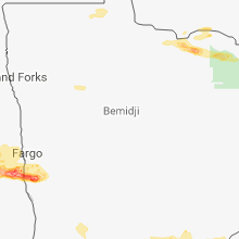
Hail Map for Saturday, August 25, 2018

Number of Impacted Households on 8/25/2018
0
Impacted by 1" or Larger Hail
0
Impacted by 1.75" or Larger Hail
0
Impacted by 2.5" or Larger Hail
Square Miles of Populated Area Impacted on 8/25/2018
0
Impacted by 1" or Larger Hail
0
Impacted by 1.75" or Larger Hail
0
Impacted by 2.5" or Larger Hail


Cities Most Affected by Hail Storms of 8/25/2018
| Hail Size | Demographics of Zip Codes Affected | ||||||
|---|---|---|---|---|---|---|---|
| City | Count | Average | Largest | Pop Density | House Value | Income | Age |
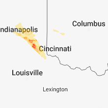
| Greensburg, IN | 3 | 2.08 | 2.75 | 73 | $89k | $40.0k | 38.8 |
| Batesville, IN | 1 | 2.75 | 2.75 | 115 | $124k | $51.3k | 38.9 |
| Davenport, ND | 1 | 2.50 | 2.50 | 3 | $83k | $53.9k | 34.6 |
| Braham, MN | 1 | 1.75 | 1.75 | 47 | $88k | $39.1k | 35.3 |
Hail and Wind Damage Spotted on 8/25/2018
Filter by Report Type:Hail ReportsWind Reports
Kentucky
| Local Time | Report Details |
|---|---|
| 8:42 AM EDT | Tree down. time estimated from rada in switzerland county IN, 22.9 miles SW of Cincinnati, OH |
| 8:42 PM EDT | Tree down. time estimated from rada in switzerland county IN, 22.9 miles SW of Cincinnati, OH |
Florida
| Local Time | Report Details |
|---|---|
| 5:05 PM EDT | Marion county 911/dispatch reports a tree downed across west highway 316 near the intersection of u.s. highway 441 in the vicinity of citra. time of damage based on rad in marion county FL, 73.7 miles SSW of Jacksonville, FL |
| 5:20 PM EDT | Marion county 911/dispatch reports a tree down across tropical park road near the intersection of woodridge drive. time of damage based on radar dat in marion county FL, 75.4 miles NW of Orlando, FL |
| 5:20 PM EDT | Marion county 911/dispatch reports trees downed across the northbound lane of southwest 140th avenue near the intersection with state road 40. time of damage based on r in marion county FL, 72.5 miles NW of Orlando, FL |
| 5:30 PM EDT | Multiple trees and branches dow in pinellas county FL, 20.1 miles NNW of Bradenton, FL |
| 7:25 PM EDT | Marion county 911/dispatch reports a tree downed across the southbound lanes of southeast 36th avenue. time of damage based on radar dat in marion county FL, 57.1 miles NW of Orlando, FL |
| 7:55 PM EDT | Marion county 911/dispatch reports a power pole downed across southeast 69th avenue in ocala. time of damage based on radar dat in marion county FL, 59.7 miles NW of Orlando, FL |
Indiana
| Local Time | Report Details |
|---|---|
| 5:20 PM EDT | Tree limbs and possibly trees down in crown cemetary. received via twitte in marion county IN, 4.5 miles NNW of Indianapolis, IN |
| 5:25 PM EDT | Small branches down. power flickering off and on. estimating 60 mph gust in marion county IN, 4.3 miles E of Indianapolis, IN |
| 6:05 PM EDT | Tree on house. time estimated by rada in rush county IN, 38.7 miles ESE of Indianapolis, IN |
| 6:25 PM EDT | Several trees down across the county... one on a hous in rush county IN, 38.8 miles ESE of Indianapolis, IN |
| 6:55 PM EDT | Tree into a house... reported by clarksburg fire dept and then forwarded via e-mail. time is approximated from rada in decatur county IN, 48.3 miles ESE of Indianapolis, IN |
| 7:09 PM EDT | Tree on house. time approximated from rada in decatur county IN, 41.3 miles SE of Indianapolis, IN |
| 7:10 PM EDT | Golf Ball sized hail reported near Greensburg, IN, 46.8 miles SE of Indianapolis, IN, approximate location (caller stated it was the east side of greensburg). |
| 7:10 PM EDT | Golf Ball sized hail reported near Greensburg, IN, 45.5 miles SE of Indianapolis, IN |
| 7:15 PM EDT | Traffic light damaged from hail. time estimated from rada in decatur county IN, 45.9 miles SE of Indianapolis, IN |
| 7:15 PM EDT | Quarter sized hail reported near Greensburg, IN, 47.7 miles ESE of Indianapolis, IN |
| 7:17 PM EDT | Baseball sized hail reported near Greensburg, IN, 47.2 miles SE of Indianapolis, IN, located at north county road 80 ne and east central avenue...the eastern city limits of greensburg. |
| 7:22 PM EDT | Baseball sized hail reported near Batesville, IN, 41.4 miles WNW of Cincinnati, OH, multiple reports of baseball sized hail around batesville. |
| 7:23 PM EDT | Tree down. time estimated from rada in ripley county IN, 38.4 miles WNW of Cincinnati, OH |
| 7:45 PM EDT | Multiple trees down over road. largest tree 2 foot diameter. time estimated from radar dat in ripley county IN, 35.4 miles W of Cincinnati, OH |
| 8:02 PM EDT | Tree down. time estimated from rada in dearborn county IN, 30.6 miles WSW of Cincinnati, OH |
| 8:08 PM EDT | Tree down. time estimated from rada in ohio county IN, 31.3 miles WSW of Cincinnati, OH |
| 8:13 PM EDT | Tree down. time estimated from rada in switzerland county IN, 34.6 miles WSW of Cincinnati, OH |
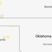
Texas
| Local Time | Report Details |
|---|---|
| 6:20 PM CDT | Measured by the ttu west texas mesonet in lamb county TX, 43 miles NW of Lubbock, TX |
South Dakota
| Local Time | Report Details |
|---|---|
| 5:47 PM MDT | Storm damage reported in oglala lakota county SD, 72.8 miles SE of Rapid City, SD |
| 6:21 PM MDT | Storm damage reported in jackson county SD, 72.3 miles ESE of Rapid City, SD |
| 8:15 PM CDT | Storm damage reported in todd county SD, 42.9 miles NW of Valentine, NE |
| 9:24 PM CDT | Storm damage reported in lyman county SD, 34.8 miles SSE of Pierre, SD |
| 10:04 PM CDT | Storm damage reported in hyde county SD, 45.7 miles E of Pierre, SD |
| 10:20 PM CDT | Storm damage reported in hyde county SD, 45.7 miles E of Pierre, SD |
Kansas
| Local Time | Report Details |
|---|---|
| 10:09 PM CDT | Davis weatherlink station north of brewster recorded a maximum wind gust of 58 mph as thunderstorm neare in thomas county KS, 17.6 miles W of Colby, KS |
North Dakota
| Local Time | Report Details |
|---|---|
| 2:10 AM CDT | Ping Pong Ball sized hail reported near Davenport, ND, 17.8 miles SW of Fargo, ND, public report of hail damage to home windows and dents in car. time estimated based on radar. |
| 2:10 AM CDT | Tennis Ball sized hail reported near Davenport, ND, 17.8 miles SW of Fargo, ND, public reports 2 - 2.5 inch hail with damage to car and barn. relayed through local media... time estimated based on radar. |
| 2:21 AM CDT | Ping Pong Ball sized hail reported near Horace, ND, 13.4 miles SSW of Fargo, ND, public reported 1.5 inch hail. time estimated by radar. |
| 2:30 AM CDT | Ping Pong Ball sized hail reported near Horace, ND, 14.3 miles S of Fargo, ND, public reports golf ball to pingpong sized hail with cracked car windshield. relayed through local media... time estimated based on radar. |
Minnesota
| Local Time | Report Details |
|---|---|
| 2:35 AM CDT | Quarter sized hail reported near Comstock, MN, 15 miles S of Fargo, ND, public called in with report of steady nickel to quarter sized hail. |
| 3:50 AM CDT | Ping Pong Ball sized hail reported near Foley, MN, 59.7 miles NNW of Minneapolis, MN |
| 4:30 AM CDT | Golf Ball sized hail reported near Braham, MN, 52 miles N of Minneapolis, MN, relayed via kanabec county warning point. time estimated based on radar. |
| 5:37 AM CDT | Half Dollar sized hail reported near Princeton, MN, 42.8 miles NNW of Minneapolis, MN |
| 5:41 AM CDT | Quarter sized hail reported near Princeton, MN, 42.5 miles NNW of Minneapolis, MN |
| 6:22 AM CDT | Quarter sized hail reported near Stacy, MN, 32 miles NNE of Minneapolis, MN |
Connect with Interactive Hail Maps