

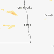
Hail Map for Saturday, August 4, 2018

Number of Impacted Households on 8/4/2018
0
Impacted by 1" or Larger Hail
0
Impacted by 1.75" or Larger Hail
0
Impacted by 2.5" or Larger Hail
Square Miles of Populated Area Impacted on 8/4/2018
0
Impacted by 1" or Larger Hail
0
Impacted by 1.75" or Larger Hail
0
Impacted by 2.5" or Larger Hail


Cities Most Affected by Hail Storms of 8/4/2018
| Hail Size | Demographics of Zip Codes Affected | ||||||
|---|---|---|---|---|---|---|---|
| City | Count | Average | Largest | Pop Density | House Value | Income | Age |
| Sioux Falls, SD | 2 | 1.75 | 1.75 | 2898 | $103k | $45.6k | 36.3 |
| Plankinton, SD | 1 | 2.50 | 2.50 | 3 | $42k | $31.9k | 36.9 |
Hail and Wind Damage Spotted on 8/4/2018
Filter by Report Type:Hail ReportsWind Reports
States Impacted
Connecticut, Massachusetts, New York, South Dakota, Kentucky, Ohio, Nebraska, Colorado, North Dakota, Iowa, MinnesotaConnecticut
| Local Time | Report Details |
|---|---|
| 9:44 AM EDT | Reports of trees down along route 169 and route 19 in windham county CT, 30.6 miles WNW of Providence, RI |
| 9:45 AM EDT | Trees and wires down on route 198 blocking road near sturbridge line. red head hill road has trees dow in windham county CT, 30.6 miles WNW of Providence, RI |
Massachusetts
| Local Time | Report Details |
|---|---|
| 9:45 AM EDT | Trees and wires down on route 198 blocking road near sturbridge lin in worcester county MA, 28.3 miles WNW of Providence, RI |
| 10:00 AM EDT | Downed tree limbs and utility poles on main street near railroad crossin in worcester county MA, 28.3 miles WNW of Providence, RI |
| 10:05 AM EDT | Main street...chase avenue...and pleasant street...many trees and power lines down. partial building collapse to metro pcs on main street. several other structures on m in worcester county MA, 28.3 miles WNW of Providence, RI |
| 10:13 AM EDT | Scofield avenue and new boston road...road blockage debris in road. several granite slabs were lifted and thrown in the roadway. tree down on west main street and centr in worcester county MA, 30.9 miles WNW of Providence, RI |
| 10:36 AM EDT | Large branches down and siding of building blown off in green acres estates in south grafto in worcester county MA, 29.4 miles NNW of Providence, RI |
| 2:30 PM EDT | Large branch down in road blocking hall street in plymouth county MA, 38.9 miles ENE of Providence, RI |
| 6:26 PM EDT | Wires down on beach street in worcester county MA, 56.9 miles NNW of Providence, RI |
| 6:39 PM EDT | Tree down on wires on johnny appleseed lane in worcester county MA, 51.4 miles NNW of Providence, RI |
New York
| Local Time | Report Details |
|---|---|
| 4:24 PM EDT | Trees and wires dow in warren county NY, 58.3 miles N of Schenectady, NY |
| 4:36 PM EDT | Tree down in roadway on stalker r in washington county NY, 59.5 miles NNE of Schenectady, NY |
| 4:43 PM EDT | Trees down on route 9n in warren county NY, 53.7 miles NNE of Schenectady, NY |
| 5:13 PM EDT | Tree down in roadway on route 22 in washington county NY, 53.9 miles NE of Schenectady, NY |
| 5:15 PM EDT | Trees and wires down on route 14 in washington county NY, 53.7 miles NE of Schenectady, NY |
| 5:27 PM EDT | Trees and wires down on burgoyne av in washington county NY, 36.5 miles NNE of Schenectady, NY |
| 5:36 PM EDT | Trees down across from the great escape along route in warren county NY, 39.1 miles NNE of Schenectady, NY |
| 6:05 PM EDT | Tree down on route 29 at stafford bridge r in saratoga county NY, 19.6 miles NNE of Schenectady, NY |
| 6:06 PM EDT | Tree and wires down on wood r in saratoga county NY, 10.8 miles NE of Schenectady, NY |
| 6:06 PM EDT | Wires down near wood road and route 9 in clifton park in saratoga county NY, 10.6 miles NE of Schenectady, NY |
| 6:09 PM EDT | Route 146 closed between river road and aqueduct road due to downed wire in schenectady county NY, 3.2 miles NE of Schenectady, NY |
| 6:17 PM EDT | Trees and wires down in rensselaer county NY, 22.4 miles ENE of Schenectady, NY |
| 6:17 PM EDT | Trees and wires down in rensselaer county NY, 14.9 miles E of Schenectady, NY |
| 6:17 PM EDT | 2 trees down along router 236 1/2 mile east of route in saratoga county NY, 11.4 miles ENE of Schenectady, NY |
| 6:19 PM EDT | Large tree limb down in albany county NY, 12.6 miles ESE of Schenectady, NY |
| 6:19 PM EDT | Trees down on the mohawk hudson bikeway in albany county NY, 12 miles E of Schenectady, NY |
| 6:28 PM EDT | Pole downed over brunswick road in eagle mills in rensselaer county NY, 18.2 miles ESE of Schenectady, NY |
| 6:36 PM EDT | Powerlines down along columbia turnpik in rensselaer county NY, 18.5 miles SE of Schenectady, NY |
| 6:37 PM EDT | Snapped telephone pole in rensselaer county NY, 20.2 miles SE of Schenectady, NY |
South Dakota
| Local Time | Report Details |
|---|---|
| 2:54 PM MDT | Ping Pong Ball sized hail reported near Rapid City, SD, 3.5 miles W of Rapid City, SD |
| 2:55 PM MDT | Quarter sized hail reported near Rapid City, SD, 1 miles E of Rapid City, SD |
| 6:01 PM MDT | Quarter sized hail reported near Sturgis, SD, 25.8 miles NNW of Rapid City, SD |
| 10:07 PM CDT | Storm damage reported in hughes county SD, 1.5 miles E of Pierre, SD |
| 12:52 AM CDT | Quarter sized hail reported near Bridgewater, SD, 31.2 miles W of Sioux Falls, SD, hail between half inch and one inch. |
| 1:02 AM CDT | Tennis Ball sized hail reported near Plankinton, SD, 83.4 miles N of Oneill, NE, via social media picture. time estimated off of radar. |
| 1:04 AM CDT | Storm damage reported in davison county SD, 67.6 miles WNW of Sioux Falls, SD |
| 1:46 AM CDT | Light pole knocked over in downtown sioux falls. time estimated from rada in minnehaha county SD, 0.4 miles S of Sioux Falls, SD |
| 1:47 AM CDT | Via social media. trees down and power out at cherry rock par in minnehaha county SD, 1.6 miles ESE of Sioux Falls, SD |
| 1:55 AM CDT | Recorded with anemomete in minnehaha county SD, 2.1 miles E of Sioux Falls, SD |
| 1:55 AM CDT | Golf Ball sized hail reported near Sioux Falls, SD, 2.1 miles E of Sioux Falls, SD, peak wind of 68 mph recorded with anemometer. |
| 1:56 AM CDT | Golf Ball sized hail reported near Sioux Falls, SD, 2.8 miles ESE of Sioux Falls, SD |
| 1:59 AM CDT | Fence and tree damage also note in minnehaha county SD, 5.1 miles E of Sioux Falls, SD |
| 2:01 AM CDT | Quarter sized hail reported near Sioux Falls, SD, 2.9 miles SSE of Sioux Falls, SD, dime to quarter size hail. report via social media. |
| 2:20 AM CDT | Tree down on house. pine tree uprooted. via social medi in lincoln county SD, 20 miles S of Sioux Falls, SD |
Kentucky
| Local Time | Report Details |
|---|---|
| 5:25 PM EDT | Several trees fell on cars. time estimated from rada in campbell county KY, 1.4 miles ESE of Cincinnati, OH |
Ohio
| Local Time | Report Details |
|---|---|
| 5:28 PM EDT | 28066kts in hamilton county OH, 4.6 miles E of Cincinnati, OH |
| 5:30 PM EDT | Large tree down on reeves golf cours in hamilton county OH, 5.1 miles E of Cincinnati, OH |
| 5:40 PM EDT | Tree branches everywhere on red bank near i-7 in hamilton county OH, 7.1 miles NE of Cincinnati, OH |
| 5:40 PM EDT | Tree branches everywhere on red bank near i-7 in hamilton county OH, 7.1 miles NE of Cincinnati, OH |
| 5:45 PM EDT | Several trees down on old 5 mile and forest road. time estimated from rada in hamilton county OH, 8.7 miles ESE of Cincinnati, OH |
Nebraska
| Local Time | Report Details |
|---|---|
| 3:38 PM MDT | Quarter sized hail reported near Sidney, NE, 60.3 miles SE of Scottsbluff, NE |
Colorado
| Local Time | Report Details |
|---|---|
| 3:45 PM MDT | Storm damage reported in larimer county CO, 47 miles N of Denver, CO |
| 3:47 PM MDT | Estimated wind gust to 60 mp in weld county CO, 26.3 miles N of Denver, CO |
| 4:08 PM MDT | Storm damage reported in arapahoe county CO, 13.1 miles E of Denver, CO |
North Dakota
| Local Time | Report Details |
|---|---|
| 5:18 PM CDT | Quarter sized hail reported near Goodrich, ND, 49.3 miles NE of Bismarck, ND, mostly pea to dime size hail with a few as large as a quarter. time estimated from radar. |
| 8:05 PM CDT | Quarter sized hail reported near Walhalla, ND, 70.5 miles NE of Devils Lake, ND, relayed by media via picture. |
Iowa
| Local Time | Report Details |
|---|---|
| 2:45 AM CDT | Trees and power lines down across town via sheriffs offic in sioux county IA, 39.7 miles SSE of Sioux Falls, SD |
| 2:56 AM CDT | Trees and power lines down across town via sheriffs offic in sioux county IA, 42.8 miles SE of Sioux Falls, SD |
| 3:10 AM CDT | Numerous trees and power lines down in sheldon. a couple flooded roadways as wel in o'brien county IA, 49.3 miles NW of Storm Lake, IA |
| 3:18 AM CDT | Archer fd reports 60 mph winds and heavy rai in o'brien county IA, 42.4 miles NW of Storm Lake, IA |
| 3:53 AM CDT | 5 inch diameter tree snapped in hal in buena vista county IA, 12.7 miles N of Storm Lake, IA |
| 3:57 AM CDT | 59 knot gus in clay county IA, 36.1 miles N of Storm Lake, IA |
Minnesota
| Local Time | Report Details |
|---|---|
| 2:52 AM CDT | 55 knot peak gust during the ten minutes preceding 259 am. exact time estimated from rada in murray county MN, 56.6 miles ENE of Sioux Falls, SD |
Connect with Interactive Hail Maps