

Hail Map for Friday, July 13, 2018

Number of Impacted Households on 7/13/2018
0
Impacted by 1" or Larger Hail
0
Impacted by 1.75" or Larger Hail
0
Impacted by 2.5" or Larger Hail
Square Miles of Populated Area Impacted on 7/13/2018
0
Impacted by 1" or Larger Hail
0
Impacted by 1.75" or Larger Hail
0
Impacted by 2.5" or Larger Hail


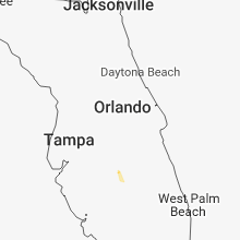


Cities Most Affected by Hail Storms of 7/13/2018
| Hail Size | Demographics of Zip Codes Affected | ||||||
|---|---|---|---|---|---|---|---|
| City | Count | Average | Largest | Pop Density | House Value | Income | Age |
| Fond Du Lac, WI | 1 | 2.00 | 2.00 | 168 | $96k | $45.6k | 42.9 |
Hail and Wind Damage Spotted on 7/13/2018
Filter by Report Type:Hail ReportsWind Reports
States Impacted
Iowa, New Mexico, Michigan, California, Wisconsin, Wyoming, Illinois, Texas, Missouri, KansasIowa
| Local Time | Report Details |
|---|---|
| 12:25 PM CDT | Em reports wind gusts of 60 mph east of sac cit in sac county IA, 20.9 miles SE of Storm Lake, IA |
| 3:31 PM CDT | Kma radio in shenandoah reported a 54 mph wind gust and a downed power lin in page county IA, 45.6 miles SE of Omaha, NE |
| 3:54 PM CDT | Tree limbs in road with strong win in washington county IA, 47.9 miles S of Cedar Rapids, IA |
| 4:00 PM CDT | 2 to 3 inch branches down with really strong win in louisa county IA, 44.5 miles SSE of Cedar Rapids, IA |
| 4:45 PM CDT | Delayed report - several large tree limbs down - via social medi in marion county IA, 38.9 miles ESE of Des Moines, IA |
| 4:49 PM CDT | Partially rotten tree down on a house. reported via nws quad citie in clayton county IA, 49.1 miles N of Cedar Rapids, IA |
| 4:51 PM CDT | Storm damage reported in buchanan county IA, 36.8 miles NNW of Cedar Rapids, IA |
| 4:54 PM CDT | Trees and power lines dow in winneshiek county IA, 44 miles SW of La Crosse, WI |
| 4:56 PM CDT | Storm damage reported in marion county IA, 36.9 miles ESE of Des Moines, IA |
| 5:08 PM CDT | Large tree down covering 3/4 of a road near highway 63 in eddyville. time estimated by rada in wapello county IA, 59.2 miles ESE of Des Moines, IA |
| 5:16 PM CDT | Large tree down blocking the road near the high school in new sharo in mahaska county IA, 50.9 miles E of Des Moines, IA |
| 5:20 PM CDT | Delayed report - 2 inch limbs dow in mahaska county IA, 50.2 miles E of Des Moines, IA |
| 5:21 PM CDT | Tree limb (unknown size) fell on power lines in oskaloos in mahaska county IA, 54.7 miles ESE of Des Moines, IA |
| 5:35 PM CDT | Measured on dvn rsois syste in scott county IA, 61.4 miles ESE of Cedar Rapids, IA |
| 5:36 PM CDT | Asos station dvn... davenport arp in scott county IA, 61.4 miles ESE of Cedar Rapids, IA |
| 5:44 PM CDT | Storm damage reported in linn county IA, 5.1 miles N of Cedar Rapids, IA |
| 5:48 PM CDT | Large tree down across street approx 1 ft in diameter with several smaller branches down as wel in linn county IA, 5.2 miles NNE of Cedar Rapids, IA |
| 6:25 PM CDT | Large limbs dow in dubuque county IA, 63.3 miles NE of Cedar Rapids, IA |
New Mexico
| Local Time | Report Details |
|---|---|
| 2:33 PM MDT | Metal storage shed destroyed by outflow winds in torrance county NM, 36.9 miles E of Albuquerque, NM |
Michigan
| Local Time | Report Details |
|---|---|
| 4:39 PM EDT | Numerous trees and power poles down across eastern rosscommon count in roscommon county MI, 68.3 miles ESE of Traverse City, MI |
| 4:46 PM EDT | Several reports of trees down and power line damage across the north half of gladwin count in gladwin county MI, 75.4 miles ESE of Traverse City, MI |
| 5:09 PM EDT | Power poles and 3 inch limbs broke in ogemaw county MI, 68 miles SSW of Alpena, MI |
| 5:25 PM EDT | Numerous reports of trees down and power line damage across northern portions of arenac count in arenac county MI, 67.3 miles SSW of Alpena, MI |
California
| Local Time | Report Details |
|---|---|
| 2:39 PM PDT | Us 95 extended closure as thunderstorm-related wind damage resulted in a train derailment... derailing 15 train cars and blocking the roadwa in san bernardino county CA, 49.5 miles NNW of Lake Havasu City, AZ |
Wisconsin
| Local Time | Report Details |
|---|---|
| 5:18 PM CDT | Hen Egg sized hail reported near Fond Du Lac, WI, 58.4 miles SSW of Green Bay, WI, hail lasted about 3 minutes. |
| 5:24 PM CDT | Quarter sized hail reported near Fond Du Lac, WI, 58.9 miles SSW of Green Bay, WI |
| 5:30 PM CDT | Quarter sized hail reported near Fond Du Lac, WI, 56.6 miles SSW of Green Bay, WI, near the fond du lac airport. |
| 5:52 PM CDT | Tree limbs down. winds estimated at 45 mp in grant county WI, 68.8 miles WSW of Madison, WI |
| 6:05 PM CDT | Tree down along town hall road east of county road in richland county WI, 53.2 miles SE of La Crosse, WI |
| 6:55 PM CDT | Structural damage...time est from rada in lafayette county WI, 53.9 miles SW of Madison, WI |
| 7:00 PM CDT | Camper rolled with multiple injurie in lafayette county WI, 49.5 miles SW of Madison, WI |
| 7:10 PM CDT | Fire dept chie in lafayette county WI, 42.8 miles SW of Madison, WI |
| 7:11 PM CDT | Several trees and large branches down and on power lines in and around the browntown area...time est by rada in green county WI, 39.7 miles SSW of Madison, WI |
| 7:25 PM CDT | Multiple reports of trees and power lines down scattered all around the count in green county WI, 34.4 miles SSW of Madison, WI |
| 7:47 PM CDT | Picture received of a large tree down across highway 73 at highway de closing highway 73 for a period of tim in dodge county WI, 31.8 miles NE of Madison, WI |
| 7:55 PM CDT | Large tree down on power lines. time est by rada in dane county WI, 9.9 miles S of Madison, WI |
| 7:59 PM CDT | Corrects the time on the previous tstm wnd dmg report from 3 sw janesville. tree down on south river roa in rock county WI, 33 miles SSE of Madison, WI |
| 8:05 PM CDT | Portion of exterior wall facade collapsed on a downtown building...time est from rada in rock county WI, 23.2 miles SE of Madison, WI |
| 8:10 PM CDT | Multiple reports of tree and power lines down around town...time est from rada in rock county WI, 29.6 miles SE of Madison, WI |
| 8:39 PM CDT | Tree down on south river roa in rock county WI, 33 miles SSE of Madison, WI |
Wyoming
| Local Time | Report Details |
|---|---|
| 5:22 PM MDT | Quarter sized hail reported near Weston, WY, 46.7 miles N of Gillette, WY, hail was bouncing 3 feet high. |
| 5:30 PM MDT | Ping Pong Ball sized hail reported near Weston, WY, 43.7 miles N of Gillette, WY, lasted 10-15 minutes |
| 6:00 PM MDT | Quarter sized hail reported near Gillette, WY, 19.5 miles SSW of Gillette, WY, smaller hail from about 555 pm to 615 pm with the quarter size hail around 600 pm. |
Illinois
| Local Time | Report Details |
|---|---|
| 6:40 PM CDT | Windows blown out and deck severely damaged on a hous in jo daviess county IL, 67.1 miles SW of Madison, WI |
| 7:00 PM CDT | Corn flattened and a 10" diameter tree spli in jo daviess county IL, 51.4 miles SSW of Madison, WI |
| 7:01 PM CDT | 2 inch tree branches broke in jo daviess county IL, 50.5 miles SSW of Madison, WI |
| 7:12 PM CDT | Shingles blown off buildings and estimated 55+ mph wind in stephenson county IL, 47.4 miles SSW of Madison, WI |
| 7:18 PM CDT | Numerous trees and power lines down within tow in stephenson county IL, 55.3 miles SSW of Madison, WI |
| 7:20 PM CDT | 2 inch tree branches broken dow in stephenson county IL, 54.9 miles SSW of Madison, WI |
| 7:45 PM CDT | Three foot diameter tree uprooted on route 75 one mile east of wheeler roa in winnebago county IL, 45.5 miles S of Madison, WI |
Texas
| Local Time | Report Details |
|---|---|
| 7:20 PM MDT | Thunderstorm wind gust at the el paso international airport... kel in el paso county TX, 11.1 miles E of El Paso, TX |
Missouri
| Local Time | Report Details |
|---|---|
| 8:51 PM CDT | Large tree limbs down. damage to outbuildings. fristoe area. time estimated by radar. pictures and report via social medi in benton county MO, 62.1 miles N of Springfield, MO |
Kansas
| Local Time | Report Details |
|---|---|
| 9:54 PM CDT | Storm damage reported in ford county KS, 46.3 miles ESE of Garden City, KS |
Connect with Interactive Hail Maps