

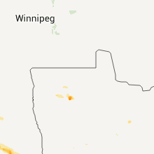
Hail Map for Sunday, July 17, 2011

Number of Impacted Households on 7/17/2011
0
Impacted by 1" or Larger Hail
0
Impacted by 1.75" or Larger Hail
0
Impacted by 2.5" or Larger Hail
Square Miles of Populated Area Impacted on 7/17/2011
0
Impacted by 1" or Larger Hail
0
Impacted by 1.75" or Larger Hail
0
Impacted by 2.5" or Larger Hail


Cities Most Affected by Hail Storms of 7/17/2011
| Hail Size | Demographics of Zip Codes Affected | ||||||
|---|---|---|---|---|---|---|---|
| City | Count | Average | Largest | Pop Density | House Value | Income | Age |
| Balfour, ND | 2 | 2.75 | 2.75 | 1 | $10k | $21.2k | 47.5 |
| Montpelier, ND | 2 | 2.00 | 2.00 | 2 | $28k | $30.0k | 43.6 |
| Page, ND | 2 | 1.75 | 1.75 | 2 | $48k | $30.3k | 41.7 |
| Valley City, ND | 1 | 2.75 | 2.75 | 24 | $65k | $30.6k | 43.1 |
| Velva, ND | 1 | 2.75 | 2.75 | 5 | $54k | $31.7k | 42.2 |
| Berlin, ND | 1 | 2.75 | 2.75 | 3 | $60k | $35.4k | 44.8 |
| Minot, ND | 1 | 2.50 | 2.50 | 144 | $86k | $32.4k | 37.7 |
| Sawyer, ND | 1 | 2.50 | 2.50 | 5 | $65k | $29.8k | 39.6 |
| Lamoure, ND | 1 | 2.00 | 2.00 | 5 | $40k | $32.3k | 44.8 |
| Harvey, ND | 1 | 1.75 | 1.75 | 6 | $49k | $33.4k | 50.7 |
| Douglas, ND | 1 | 1.75 | 1.75 | 1 | $34k | $31.7k | 48.0 |
| Voltaire, ND | 1 | 1.75 | 1.75 | 1 | $39k | $29.5k | 50.6 |
| Fessenden, ND | 1 | 1.75 | 1.75 | 2 | $31k | $34.4k | 52.8 |
| New Rockford, ND | 1 | 1.75 | 1.75 | 6 | $37k | $29.1k | 49.9 |
| Jamestown, ND | 1 | 1.75 | 1.75 | 39 | $71k | $33.6k | 42.3 |
Hail and Wind Damage Spotted on 7/17/2011
Filter by Report Type:Hail ReportsWind Reports
North Dakota
| Local Time | Report Details |
|---|---|
| 2:48 PM UTC | Golf Ball sized hail reported near Douglas, ND, 19 miles SW of Minot, ND, report relayed by the media. |
| 3:10 PM UTC | Tennis Ball sized hail reported near Minot, ND, 9.1 miles SE of Minot, ND, 8 miles east of the old radar base. report relayed by media. |
| 3:25 PM UTC | Tennis Ball sized hail reported near Sawyer, ND, 18.8 miles SE of Minot, ND, report relayed by media. |
| 3:38 PM UTC | Baseball sized hail reported near Velva, ND, 22.1 miles SE of Minot, ND, report relayed by the media. |
| 3:40 PM UTC | Golf Ball sized hail reported near Voltaire, ND, 25.8 miles SE of Minot, ND, report relayed by the media. |
| 3:50 PM UTC | Golf Ball sized hail reported near , , 31.6 miles ESE of Minot, ND, report relayed by the media. |
| 3:56 PM UTC | Baseball sized hail reported near Balfour, ND, 40.2 miles ESE of Minot, ND, also reports heavy rain. large hail ended at 1110 am cdt. estimated winds at 50-60 mph with no visible damage from his home. |
| 4:06 PM UTC | Baseball sized hail reported near Balfour, ND, 40.2 miles ESE of Minot, ND, report relayed by the media. |
| 5:15 PM UTC | Quarter sized hail reported near Maddock, ND, 38.6 miles WSW of Devils Lake, ND, dime to quarter sized hail driven by very strong winds produced widespread crop damage near the wells county line. |
| 5:22 PM UTC | Golf Ball sized hail reported near Fessenden, ND, 43 miles WSW of Devils Lake, ND, report relayed by the media. |
| 5:28 PM UTC | Golf Ball sized hail reported near Harvey, ND, 43 miles WSW of Devils Lake, ND |
| 5:45 PM UTC | Golf Ball sized hail reported near Bremen, ND, 35.2 miles SW of Devils Lake, ND, report relayed by the media. |
| 5:55 PM UTC | Quarter sized hail reported near New Rockford, ND, 33 miles SSW of Devils Lake, ND |
| 6:06 PM UTC | Golf Ball sized hail reported near New Rockford, ND, 32.6 miles SSW of Devils Lake, ND |
| 6:07 PM UTC | High winds in town blew down trees with some street flooding due to the heavy rai in eddy county ND, 32.6 miles SSW of Devils Lake, ND |
| 6:07 PM UTC | 2 power poles snapped along us highway 281 in eddy county ND, 36.5 miles SSW of Devils Lake, ND |
| 9:07 PM UTC | Rotation in the storm. no hail. funnel clouds have dissipate in stutsman county ND, 66.8 miles E of Bismarck, ND |
| 9:15 PM UTC | Baseball sized hail reported near Valley City, ND, 51.2 miles WNW of Fargo, ND |
| 9:22 PM UTC | Hen Egg sized hail reported near Montpelier, ND, 84.7 miles N of Aberdeen, SD, relayed by media. |
| 9:34 PM UTC | Ndhp reports 100 feet visibility along interstate 94 in very heavy rain and very high wind. pea size hai in stutsman county ND, 82.7 miles E of Bismarck, ND |
| 9:36 PM UTC | Golf Ball sized hail reported near Page, ND, 42.1 miles WNW of Fargo, ND, public report relayed via media |
| 10:10 PM UTC | Ping Pong Ball sized hail reported near Ayr, ND, 31.2 miles WNW of Fargo, ND |
| 10:10 PM UTC | Golf Ball sized hail reported near Jamestown, ND, 91.4 miles S of Devils Lake, ND |
| 10:11 PM UTC | Golf Ball sized hail reported near Page, ND, 37.6 miles WNW of Fargo, ND |
| 10:22 PM UTC | Hen Egg sized hail reported near Montpelier, ND, 84.7 miles N of Aberdeen, SD, corrected time of event from 422 pm cdt to 522 pm cdt and size of hail from 0.25 inch to 2.00 inch diameter. error was that of the nws in typing the report. relayed by |
| 10:25 PM UTC | Ping Pong Ball sized hail reported near Ayr, ND, 29.7 miles WNW of Fargo, ND, public report and photo received via media facebook page. hail occurred between 525 and 530 pm cdt. |
| 11:18 PM UTC | Hen Egg sized hail reported near Lamoure, ND, 65.2 miles N of Aberdeen, SD, golfball to 2 inch hail |
| 11:24 PM UTC | Baseball sized hail reported near Berlin, ND, 64.3 miles N of Aberdeen, SD, golfball to baseball size hail |
| 11:29 PM UTC | Quarter sized hail reported near Lamoure, ND, 62.9 miles N of Aberdeen, SD, hail lasted 5 minutes. |
| 12:20 AM UTC | Time is estimated based on radar. many trees snapped around merricourt...mainly evergreen. all lying in a similar directio in dickey county ND, 53.5 miles NNW of Aberdeen, SD |
| 12:32 AM UTC | Storm damage reported in sargent county ND, 62.7 miles NNE of Aberdeen, SD |
| 12:47 AM UTC | Very high winds east of gwinner...near zero visibility with wind and rain...and the highway has several tree branches across it in sargent county ND, 59.8 miles SW of Fargo, ND |
| 1:10 AM UTC | A four to six inch diameter birch tree...roughly 40 feet tall...came down with high winds ... spotter received 0.59 inches of rain in sargent county ND, 59.8 miles SSW of Fargo, ND |
| 1:12 AM UTC | Winds approaching 60 mph brought down 3 to 4 inch tree branche in richland county ND, 58.4 miles SSW of Fargo, ND |
| 1:12 AM UTC | Winds approaching 60 mph brought down 3 to 4 inch tree branche in richland county ND, 57.1 miles SSW of Fargo, ND |
| 1:15 AM UTC | Thunderstorm wind caused tree to crash into house. some trees uproote in richland county ND, 58.4 miles SSW of Fargo, ND |
| 1:16 AM UTC | Several two inch to three inch diameter branches down in lidgerwood...mostly from cottonwood trees in richland county ND, 58.4 miles SSW of Fargo, ND |
| 1:30 AM UTC | Thunderstorm wind caused tree to crash into hous in richland county ND, 58.4 miles SSW of Fargo, ND |
| 1:46 AM UTC | Peak winds measured by the nddot rwis site along nd hwy 13 near mile post 384. in richland county ND, 41.9 miles S of Fargo, ND |
| 1:55 AM UTC | Report of wahpeton apt awos in richland county ND, 42.6 miles S of Fargo, ND |
| 1:55 AM UTC | Report of wahpeton apt kbwp awo in richland county ND, 44.7 miles S of Fargo, ND |
Minnesota
| Local Time | Report Details |
|---|---|
| 5:30 PM UTC | Branches at the top of trees up to 6 inches in diameter broken of in chippewa county MN, 1.5 miles SSE of Montevideo, MN |
| 8:05 PM UTC | 14 inch diameter trees felled in north bemidji. street flooding reported as wel in beltrami county MN, 0.5 miles N of Bemidji, MN |
| 9:10 PM UTC | Tree branches down in koochiching county MN, 43.6 miles NE of Bemidji, MN |
| 9:16 PM UTC | Large tree across road in itasca county MN, 36.5 miles ENE of Bemidji, MN |
| 2:15 AM UTC | Quarter sized hail reported near Wheaton, MN, 67.5 miles SSE of Fargo, ND |
| 2:55 AM UTC | Peak wind measured at ky63... the elbow lake airpor in grant county MN, 72.2 miles N of Montevideo, MN |
| 4:45 AM UTC | Large tree down across county rd in kandiyohi county MN, 39 miles E of Montevideo, MN |
| 11:20 AM UTC | Few branches down in city. city without power for about 30 minute in wabasha county MN, 55.3 miles NW of La Crosse, WI |
| 11:50 AM UTC | Quarter sized hail reported near Finland, MN, 61.1 miles NE of Duluth, MN |
Wisconsin
| Local Time | Report Details |
|---|---|
| 11:03 PM UTC | Trees blown down near highway 63 around grand view. several other reports received by bayfield county dispatch of trees blown dow in bayfield county WI, 55.3 miles ESE of Duluth, MN |
| 11:05 PM UTC | Trees blown down around drummon in bayfield county WI, 51 miles SE of Duluth, MN |
| 11:55 PM UTC | Trees down - time estimated by rada in vilas county WI, 19 miles N of Rhinelander, WI |
| 12:00 AM UTC | 60-70 mph...12-14 inch trees down across cty e in price county WI, 54.1 miles WNW of Rhinelander, WI |
| 12:00 AM UTC | Power poles blown down in addition to tree damag in price county WI, 54.1 miles WNW of Rhinelander, WI |
| 12:10 AM UTC | Trees blown down near fishermans landing. dispatch also reports trees blown down in several other parts of the count in iron county WI, 46.8 miles NW of Rhinelander, WI |
| 12:15 AM UTC | Some campers stranded on the flowage as their canoes or watercraft were blown away from the campsit in iron county WI, 48.1 miles NW of Rhinelander, WI |
| 12:35 AM UTC | Storm damage reported in oneida county WI, 5.6 miles NW of Rhinelander, WI |
| 12:42 AM UTC | Multiple reports of trees being blown down...and tree limbs bringing down power lines in and around haywar in sawyer county WI, 61.4 miles SSE of Duluth, MN |
| 12:45 AM UTC | Trees and power lines in oneida county WI, 16 miles NE of Rhinelander, WI |
| 12:45 AM UTC | Tree limbs and power lines down in township of emer in price county WI, 39.9 miles W of Rhinelander, WI |
| 12:52 AM UTC | Tree down on a wire along hwy 55 in forest county WI, 37.4 miles NE of Rhinelander, WI |
| 12:55 AM UTC | Trees and power lines down in oneida county WI, 0.6 miles S of Rhinelander, WI |
| 1:00 AM UTC | Trees and power lines down in lincoln county WI, 18.1 miles WSW of Rhinelander, WI |
| 1:00 AM UTC | Trees and power lines down in lincoln county WI, 19.8 miles SW of Rhinelander, WI |
| 1:10 AM UTC | Power pole down - report relayed by law enforcement in langlade county WI, 18.3 miles SE of Rhinelander, WI |
| 1:30 AM UTC | Trees and power lines down in lincoln county WI, 34.2 miles SSW of Rhinelander, WI |
| 1:42 AM UTC | Tree down on county hwy b near aurora in florence county WI, 62.7 miles E of Rhinelander, WI |
| 1:52 AM UTC | Tree down on county hwy f in oconto county WI, 52.9 miles ESE of Rhinelander, WI |
| 2:09 AM UTC | Large tree down at 11th avenue and stewart avenue in marathon county WI, 48 miles SSW of Rhinelander, WI |
| 2:15 AM UTC | Trees down on highway 47 and highway m in menominee county WI, 50.9 miles NW of Green Bay, WI |
| 2:18 AM UTC | Trees down in marathon county WI, 51.7 miles S of Rhinelander, WI |
| 2:45 AM UTC | Trees down in portage county WI, 62.9 miles W of Green Bay, WI |
| 2:50 AM UTC | Trees down. power ou in waupaca county WI, 54.4 miles W of Green Bay, WI |
| 2:50 AM UTC | Trees and power lines down across whole county...worst damage in peshtigo are in marinette county WI, 38.6 miles NNE of Green Bay, WI |
| 2:50 AM UTC | Large tree down at intersection of hwy 187 and 156 in shawano county WI, 27.5 miles WNW of Green Bay, WI |
| 3:05 AM UTC | 14 inch tree limb down in waupaca county WI, 53.3 miles WSW of Green Bay, WI |
| 3:20 AM UTC | Power line down on highway 22 in waushara county WI, 65.6 miles WSW of Green Bay, WI |
| 3:25 AM UTC | Trees and power lines down in sturgeon bay and across the rest of southern door county in door county WI, 38 miles NE of Green Bay, WI |
| 3:35 AM UTC | Tree down on power lines - tree on fire in kewaunee county WI, 24.2 miles ENE of Green Bay, WI |
| 3:50 AM UTC | Trees down in winnebago county WI, 31.3 miles SW of Green Bay, WI |
| 3:55 AM UTC | Trees and power lines down in manitowoc county WI, 20.3 miles SSE of Green Bay, WI |
| 4:00 AM UTC | Storm damage reported in manitowoc county WI, 24.3 miles SE of Green Bay, WI |
| 4:05 AM UTC | Power line down just east of u.s. highway 41 near fond du lac county/winnebago county line. time estimated from rada in fond du lac county WI, 49.7 miles SSW of Green Bay, WI |
| 4:15 AM UTC | Trees and power lines down in calumet county WI, 34.2 miles SSW of Green Bay, WI |
| 11:45 AM UTC | A few large trees down that blocked roa in jackson county WI, 46 miles N of La Crosse, WI |
Arizona
| Local Time | Report Details |
|---|---|
| 11:20 PM UTC | Roof peeled off home near 22nd st and eli st. part of the roof landed in the stree in pima county AZ, 7.1 miles E of Tucson, AZ |
New York
| Local Time | Report Details |
|---|---|
| 12:18 AM UTC | Trees and power lines down in st. lawrence county NY, 8.7 miles ENE of Ogdensburg, NY |
| 12:20 AM UTC | 100-ft tall pine down on a truck in st. lawrence county NY, 0.3 miles S of Ogdensburg, NY |
| 12:20 AM UTC | Trees and power lines down in st. lawrence county NY, 11 miles SE of Ogdensburg, NY |
| 12:22 AM UTC | Telephone poles and power lines down in st. lawrence county NY, 33.7 miles ENE of Ogdensburg, NY |
| 12:24 AM UTC | Trees and power lines down in st. lawrence county NY, 17 miles ESE of Ogdensburg, NY |
| 12:24 AM UTC | Trees and power lines down in franklin county NY, 52.7 miles ENE of Ogdensburg, NY |
| 12:24 AM UTC | Trees and power lines down in st. lawrence county NY, 25.2 miles E of Ogdensburg, NY |
| 12:30 AM UTC | Trees and power lines down in st. lawrence county NY, 33.8 miles E of Ogdensburg, NY |
| 12:35 AM UTC | Trees and fence blown down in yard... storage shed ruined in st. lawrence county NY, 0.3 miles S of Ogdensburg, NY |
| 12:42 AM UTC | Trees and power lines down in franklin county NY, 59 miles WNW of Burlington, VT |
| 12:48 AM UTC | Trees and power lines down in franklin county NY, 55.5 miles WNW of Burlington, VT |
| 1:01 AM UTC | Public in franklin county NY, 53 miles NW of Burlington, VT |
| 1:08 AM UTC | Lightning hit power lines and they are on fire... tree limbs down in franklin county NY, 46.8 miles E of Ogdensburg, NY |
| 1:35 AM UTC | Reported by public in franklin county NY, 52.5 miles W of Burlington, VT |
| 1:48 AM UTC | Trees down in clinton county NY, 26.1 miles W of Burlington, VT |
Michigan
| Local Time | Report Details |
|---|---|
| 2:00 AM UTC | Trees were reported down on powerlines along anderson road in daggett county between 2100 and 2130 cd in menominee county MI, 68.4 miles NNE of Green Bay, WI |
| 4:20 AM UTC | 2 trees and powerlines down. one of the trees down onto a garag in cheboygan county MI, 59.1 miles S of Sault Sainte Marie, MI |
| 4:25 AM UTC | Storm damage reported in charlevoix county MI, 42.4 miles NNE of Traverse City, MI |
| 5:00 AM UTC | Between 6 and 8 trees were cleaned up off the road near u.s. 10 just south of scottville. report is both time and location estimate in mason county MI, 65.5 miles SSW of Traverse City, MI |
| 5:05 AM UTC | Mason county dispatch reports a tree down at north harrison street and east fitch street in ludington. time estimated by rada in mason county MI, 69 miles SW of Traverse City, MI |
| 5:30 AM UTC | Reports of trees down in various parts of the count in montmorency county MI, 34.8 miles W of Alpena, MI |
| 5:30 AM UTC | Oceana county dispatch reports numerous trees down on power lines in the city of shelby. time estimated by rada in oceana county MI, 56.4 miles NW of Grand Rapids, MI |
| 5:35 AM UTC | Oceana county dispatch reports several large trees blocking roads in ferry. time estimated by rada in oceana county MI, 50.6 miles NNW of Grand Rapids, MI |
Vermont
| Local Time | Report Details |
|---|---|
| 2:10 AM UTC | Large branches down and barn roof damaged in chittenden county VT, 10.8 miles S of Burlington, VT |
Connect with Interactive Hail Maps