

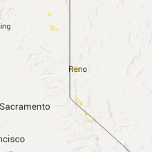
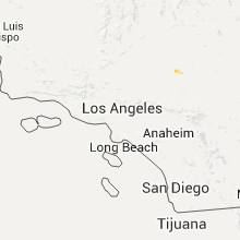
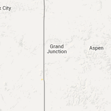
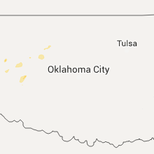
Hail Map for Monday, July 6, 2015

Number of Impacted Households on 7/6/2015
0
Impacted by 1" or Larger Hail
0
Impacted by 1.75" or Larger Hail
0
Impacted by 2.5" or Larger Hail
Square Miles of Populated Area Impacted on 7/6/2015
0
Impacted by 1" or Larger Hail
0
Impacted by 1.75" or Larger Hail
0
Impacted by 2.5" or Larger Hail


Cities Most Affected by Hail Storms of 7/6/2015
| Hail Size | Demographics of Zip Codes Affected | ||||||
|---|---|---|---|---|---|---|---|
| City | Count | Average | Largest | Pop Density | House Value | Income | Age |
Hail and Wind Damage Spotted on 7/6/2015
Filter by Report Type:Hail ReportsWind Reports
States Impacted
Illinois, Nebraska, Kansas, New Mexico, Missouri, Iowa, Texas, Wisconsin, Oklahoma, Nevada, Arizona, TennesseeIllinois
| Local Time | Report Details |
|---|---|
| 1:30 PM CDT | Large oak tree snapped ontu roof of home. time estimated from rada in madison county IL, 6.8 miles NNE of Saint Louis, MO |
| 4:20 PM CDT | A few car windows blown out at south park mall parking lo in rock island county IL, 69.8 miles ESE of Cedar Rapids, IA |
| 4:20 PM CDT | Damage to roof and siding blown off on fedex and kinkos building near south park mall and john deere roa in rock island county IL, 69.8 miles ESE of Cedar Rapids, IA |
| 4:28 PM CDT | Damage to roof and siding blown off on fedex and kinkos building near south park mall and john deere roa in rock island county IL, 69.8 miles ESE of Cedar Rapids, IA |
| 5:05 PM CDT | Smaller trees blowing sideways. extremly wind in henry county IL, 58.7 miles NNW of Peoria, IL |
| 5:26 PM CDT | 5 inch diameter tree branch blown down on top of hous in henry county IL, 59.6 miles NNW of Peoria, IL |
Nebraska
| Local Time | Report Details |
|---|---|
| 1:45 PM CDT | Several 6 to 8 inch diameter tree limbs blown down in town during a thunderstorm with very heavy rai in pawnee county NE, 67.9 miles NNE of Manhattan, KS |
Kansas
| Local Time | Report Details |
|---|---|
| 2:59 PM CDT | Storm damage reported in geary county KS, 19.6 miles SW of Manhattan, KS |
| 3:11 PM CDT | Several 2-3 inch tree limbs down in geary county KS, 16.2 miles SW of Manhattan, KS |
| 3:37 PM CDT | 60-65 mph winds in wabaunsee county KS, 17.8 miles SE of Manhattan, KS |
| 3:54 PM CDT | 70-80 mph winds with tree blown over in wabaunsee county KS, 30.3 miles ESE of Manhattan, KS |
| 4:15 PM CDT | Dead limbs down. power out. estimated 70 mp in osage county KS, 45.6 miles ESE of Manhattan, KS |
| 4:20 PM CDT | Storm damage reported in shawnee county KS, 44.3 miles ESE of Manhattan, KS |
| 4:40 PM CDT | Storm damage reported in wyandotte county KS, 12.5 miles WNW of Kansas City, MO |
| 4:44 PM CDT | Storm damage reported in wyandotte county KS, 12.5 miles WNW of Kansas City, MO |
| 4:53 PM CDT | 3 inch tree limbs down at felker park estimated at 420 pm in shawnee county KS, 46.6 miles ESE of Manhattan, KS |
| 4:59 PM CDT | 10 inch diameter tree limbs down at 2300 lawrence av in douglas county KS, 39.8 miles WSW of Kansas City, MO |
| 5:00 PM CDT | Storm damage reported in butler county KS, 28.1 miles ENE of Wichita, KS |
| 5:00 PM CDT | Public report via twitter of roof damage to a home with an estimated 60 to 70 mph winds. time is based on rada in butler county KS, 19.5 miles E of Wichita, KS |
| 5:00 PM CDT | Public report via twitter of 60 to 70 mph winds. time is based on rada in butler county KS, 19.5 miles E of Wichita, KS |
| 5:01 PM CDT | Trailer overturned near butler co. comm. college.... also power poles down as wel in butler county KS, 26.6 miles ENE of Wichita, KS |
| 5:03 PM CDT | 65 to 70 mph winds in el dorado with tree damag in butler county KS, 27.6 miles ENE of Wichita, KS |
| 5:38 PM CDT | Delayed report...possible tornado...trees damaged at hwy 7 and college blvd in johnson county KS, 19.1 miles SW of Kansas City, MO |
| 5:48 PM CDT | 70 to 80 mph winds around 4 miles south of rose hil in butler county KS, 13.9 miles SE of Wichita, KS |
| 5:49 PM CDT | Numerous trees reported blown down near olathe northwest high schoo in johnson county KS, 18.3 miles SW of Kansas City, MO |
| 6:03 PM CDT | Report of 6 inch tree limb down at 132 st and antioc in johnson county KS, 15.8 miles SSW of Kansas City, MO |
| 6:36 PM CDT | Tree limb 5 inches in diameter down at 75th and hard in johnson county KS, 9.7 miles SSW of Kansas City, MO |
New Mexico
| Local Time | Report Details |
|---|---|
| 2:03 PM MDT | *** 1 inj *** wet microburst winds damaged 2 grain silos... one collapsed onto pickup truck... tree damage noted in are in curry county NM, 59 miles SSE of Tucumcari, NM |
| 4:08 PM MDT | Large wooden doors on a barn were blown off. several trees had severe damage. plastic roof of a greenhouse was blown off. metal tail of a windmill was wrapped around th in guadalupe county NM, 36.9 miles WSW of Tucumcari, NM |
Missouri
| Local Time | Report Details |
|---|---|
| 3:08 PM CDT | Small limb blown down in dekalb county MO, 49.5 miles N of Kansas City, MO |
| 5:00 PM CDT | Photos of tree damage at north oak trfwy and englewood r in clay county MO, 6.7 miles N of Kansas City, MO |
| 5:06 PM CDT | 3 miles north of gladstone in clay county MO, 11 miles N of Kansas City, MO |
| 5:10 PM CDT | Debris reported at intersection in clay county MO, 11.5 miles NE of Kansas City, MO |
| 5:26 PM CDT | Tree damage reported at 94th and oa in clay county MO, 10.8 miles N of Kansas City, MO |
| 5:37 PM CDT | Reports of damage and windows blown out at wal-mart and adjacent gas statio in clay county MO, 11.5 miles NE of Kansas City, MO |
| 6:49 PM CDT | Trees down on hwy 45 near iata in platte county MO, 33.6 miles NW of Kansas City, MO |
Iowa
| Local Time | Report Details |
|---|---|
| 3:37 PM CDT | Time estimated from rada in muscatine county IA, 49.9 miles SSE of Cedar Rapids, IA |
| 3:37 PM CDT | Utility poles and several trees down near fruitland road and spitz drive...time estimated from rada in muscatine county IA, 51.6 miles SSE of Cedar Rapids, IA |
| 3:45 PM CDT | Time corrected to 345 pm cd in muscatine county IA, 49.9 miles SSE of Cedar Rapids, IA |
| 5:24 PM CDT | Lee county em reporting strong winds on hwy 3 in jefferson county IA, 42.7 miles NNW of Kahoka, MO |
| 5:25 PM CDT | 2 to 3 inch diameter tree banches down in tow in jefferson county IA, 42.7 miles NNW of Kahoka, MO |
Texas
| Local Time | Report Details |
|---|---|
| 4:29 PM CDT | Storm damage reported in deaf smith county TX, 27.3 miles SW of Amarillo, TX |
| 4:29 PM CDT | Storm damage reported in deaf smith county TX, 26.4 miles SW of Amarillo, TX |
| 6:05 PM CDT | Storm damage reported in gray county TX, 59.5 miles NNW of Childress, TX |
| 6:05 PM CDT | Power poles down along 1585 in lubbock county TX, 7.9 miles S of Lubbock, TX |
| 6:07 PM CDT | Storm damage reported in lubbock county TX, 9.3 miles SSW of Lubbock, TX |
| 6:15 PM CDT | 8 power poles down near 130th and frankford in lubbock county TX, 5.6 miles SSW of Lubbock, TX |
Wisconsin
| Local Time | Report Details |
|---|---|
| 5:59 PM CDT | Trees and powerlines down at intersection of hwy 22 and 32. reported forwarded by nbc 26. time of event estimate in oconto county WI, 29.2 miles NNW of Green Bay, WI |
| 9:50 PM CDT | Tree 2 feet in diameter snapped. 4 saplings knocked over. occured in 1 block area. appears to be a localized wet microburst from a non-thunderstorm shower complex. time in dane county WI, 6.5 miles WNW of Madison, WI |
Oklahoma
| Local Time | Report Details |
|---|---|
| 8:12 PM CDT | Storm damage reported in garfield county OK, 63.5 miles NNW of Oklahoma City, OK |
| 8:41 PM CDT | Measured with hand anemometer in blaine county OK, 56.4 miles WNW of Oklahoma City, OK |
Nevada
| Local Time | Report Details |
|---|---|
| 6:32 PM PDT | Quarter sized hail reported near Las Vegas, NV, 11.1 miles WNW of Las Vegas, NV, quarter size hail reported at cheyenne and highway 215 |
Arizona
| Local Time | Report Details |
|---|---|
| 7:35 PM MST | Numerous power poles blown dow in maricopa county AZ, 34.3 miles NW of Phoenix, AZ |
Tennessee
| Local Time | Report Details |
|---|---|
| 2:37 AM CDT | Trees down in union city...report relayed by nws paduca in obion county TN, 35.6 miles NW of Mc Kenzie, TN |
Connect with Interactive Hail Maps