

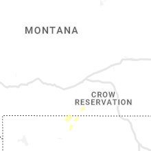
Hail Map for Sunday, June 19, 2022

Number of Impacted Households on 6/19/2022
0
Impacted by 1" or Larger Hail
0
Impacted by 1.75" or Larger Hail
0
Impacted by 2.5" or Larger Hail
Square Miles of Populated Area Impacted on 6/19/2022
0
Impacted by 1" or Larger Hail
0
Impacted by 1.75" or Larger Hail
0
Impacted by 2.5" or Larger Hail


Cities Most Affected by Hail Storms of 6/19/2022
| Hail Size | Demographics of Zip Codes Affected | ||||||
|---|---|---|---|---|---|---|---|
| City | Count | Average | Largest | Pop Density | House Value | Income | Age |
| Alzada, MT | 2 | 2.25 | 2.50 | 0 | $138k | $33.8k | 52.5 |
| Ignacio, CO | 1 | 1.75 | 1.75 | 11 | $110k | $36.9k | 39.2 |
Hail and Wind Damage Spotted on 6/19/2022
Filter by Report Type:Hail ReportsWind Reports
States Impacted
Utah, Florida, Colorado, Louisiana, Wyoming, New Mexico, Montana, Michigan, Kansas, South Dakota, Nevada, North DakotaUtah
| Local Time | Report Details |
|---|---|
| 7:10 AM MDT | Indian canyon summit in duchesne county UT, 20.2 miles N of Price, UT |
| 9:10 AM MDT | Quarter sized hail reported near Helper, UT, 6.7 miles NNW of Price, UT, public reports quarter sized hail with photo via social media. |
| 9:10 AM MDT | Half Dollar sized hail reported near Helper, UT, 6.7 miles NNW of Price, UT, public reports half dollar sized hail with reference photo via social media. |
| 9:10 AM MDT | Yellowstone drainage raws reports tstorm wind gust to 68 mp in duchesne county UT, 69.6 miles NNE of Price, UT |
| 9:13 AM MDT | Yellowstone drainage raws observed thunderstorm wind gust to 68 mp in duchesne county UT, 69.6 miles NNE of Price, UT |
| 2:30 PM MDT | Pom north side hf012 in salt lake county UT, 20 miles S of Salt Lake City, UT |
| 2:30 PM MDT | I-80 at grassey utgrs in tooele county UT, 58.9 miles W of Salt Lake City, UT |
| 2:45 PM MDT | Lakeside mountain lmr in box elder county UT, 56.4 miles WNW of Salt Lake City, UT |
| 2:50 PM MDT | I-80 at mp 79 timpie uttim in tooele county UT, 37.4 miles W of Salt Lake City, UT |
| 2:50 PM MDT | I-80 at mp 78 ut31 in tooele county UT, 38.4 miles W of Salt Lake City, UT |
| 2:50 PM MDT | I-80 at mp 68 west delle utwdl in tooele county UT, 47.9 miles W of Salt Lake City, UT |
| 3:00 PM MDT | I-80 at mp 81 dolomite in tooele county UT, 35.4 miles W of Salt Lake City, UT |
| 3:00 PM MDT | I-80 at mp 71 east delle in tooele county UT, 45.8 miles W of Salt Lake City, UT |
| 3:15 PM MDT | Marina kcc02 in salt lake county UT, 17 miles W of Salt Lake City, UT |
| 3:30 PM MDT | Fremont island - miller hill freut in weber county UT, 35.5 miles NW of Salt Lake City, UT |
| 3:30 PM MDT | Gunnison island gni in box elder county UT, 63.8 miles NW of Salt Lake City, UT |
| 3:40 PM MDT | Lake mountain pc221 in utah county UT, 33.2 miles S of Salt Lake City, UT |
| 3:45 PM MDT | Parleys canyon at quarry utqry in salt lake county UT, 6.5 miles ESE of Salt Lake City, UT |
| 3:50 PM MDT | Mount aire canyon pc022 in salt lake county UT, 7.9 miles E of Salt Lake City, UT |
| 4:00 PM MDT | Roof shingle damage to home on roy/west haven line in weber county UT, 29.4 miles NNW of Salt Lake City, UT |
Florida
| Local Time | Report Details |
|---|---|
| 2:38 PM EDT | Tree on house and partial roof remova in sumter county FL, 47.7 miles WNW of Orlando, FL |
| 4:25 PM EDT | A member of the public sent a video showing damage from a thunderstorm in the century village community in pembroke pines. downed branches and a downed light pole were in broward county FL, 19.5 miles NNW of Miami, FL |
| 5:40 PM EDT | Asos station kpie st pete-clearwater int'' in gmz830 county FL, 29.9 miles NNW of Bradenton, FL |
Colorado
| Local Time | Report Details |
|---|---|
| 1:45 PM MDT | Storm damage reported in montezuma county CO, 36.1 miles NNW of Farmington, NM |
| 1:50 PM MDT | Quarter sized hail reported near Mesa Verde National Park, CO, 36.8 miles NNW of Farmington, NM, covered the ground up to 6 inches. |
| 2:10 PM MDT | Quarter sized hail reported near Mesa Verde National Park, CO, 38.2 miles NNW of Farmington, NM, mesa verde np personnel reported hail lasted until approx. 220 pm mdt. hail dimpled at least 2 vehicles. |
| 3:32 PM MDT | Golf Ball sized hail reported near Ignacio, CO, 41.2 miles NE of Farmington, NM, public report with pictures via social media. size estimated between 1.5 and 2 inches. |
| 5:29 PM MDT | Corrects previous tstm wnd gst report from 3 w pueblo wes in pueblo county CO, 11 miles WNW of Pueblo, CO |
Louisiana
| Local Time | Report Details |
|---|---|
| 3:17 PM CDT | Klch reports thunderstorm wind gust to 67 mph (58 kts in calcasieu county LA, 31 miles E of Beaumont, TX |
| 3:20 PM CDT | Lch tower officials report a small airplane flipped by wind gust in calcasieu county LA, 31 miles E of Beaumont, TX |
Wyoming
| Local Time | Report Details |
|---|---|
| 2:30 PM MDT | Tree damage and a power line down from strong win in natrona county WY, 38.7 miles N of Casper, WY |
| 2:50 PM MDT | Asos station kgey greybull airpor in big horn county WY, 89.7 miles SSE of Billings, MT |
| 5:24 PM MDT | Quarter sized hail reported near Weston, WY, 46.7 miles NNE of Gillette, WY, hail covered the ground |
New Mexico
| Local Time | Report Details |
|---|---|
| 3:18 PM MDT | Quarter sized hail reported near San Fidel, NM, 53.9 miles W of Albuquerque, NM, quarter size hail up to 1 inch deep with very heavy rain. |
| 3:25 PM MDT | Quarter sized hail reported near Cubero, NM, 49.4 miles W of Albuquerque, NM, 0.8 rain... 24 mph wind... temp dropped 10 degrees. |
Montana
| Local Time | Report Details |
|---|---|
| 4:30 PM MDT | Storm damage reported in big horn county MT, 53.7 miles ESE of Billings, MT |
| 6:09 PM MDT | Hen Egg sized hail reported near Alzada, MT, 72.4 miles NE of Gillette, WY |
| 6:09 PM MDT | Tennis Ball sized hail reported near Alzada, MT, 72.4 miles NE of Gillette, WY |
Michigan
| Local Time | Report Details |
|---|---|
| 7:14 PM EDT | Quarter sized hail reported near Lanse, MI, 46.2 miles W of Marquette, MI, quarter size hail reported. |
Kansas
| Local Time | Report Details |
|---|---|
| 6:28 PM CDT | Report from mping: 1-inch tree limbs broken; shingles blown of in gove county KS, 49.2 miles ESE of Colby, KS |
South Dakota
| Local Time | Report Details |
|---|---|
| 5:59 PM MDT | Storm damage reported in jackson county SD, 72.3 miles ESE of Rapid City, SD |
| 6:05 PM MDT | Storm damage reported in jackson county SD, 69.3 miles E of Rapid City, SD |
| 7:06 PM MDT | Half Dollar sized hail reported near Buffalo, SD, 92.8 miles NNW of Rapid City, SD, mostly quarters...covered the ground...also had 50 mph winds |
| 8:09 PM CDT | Asos station kmbg mobridge muni a in walworth county SD, 81.6 miles N of Pierre, SD |
| 8:14 PM CDT | Storm damage reported in walworth county SD, 77.7 miles N of Pierre, SD |
| 8:24 PM CDT | Mound city 5 wsw pw in campbell county SD, 81.9 miles SSE of Bismarck, ND |
| 7:40 PM MDT | Quarter sized hail reported near Buffalo, SD, 104.7 miles N of Rapid City, SD |
| 7:40 PM MDT | Storm damage reported in harding county SD, 104.7 miles N of Rapid City, SD |
| 8:40 PM CDT | 2n herreid rwis(sddot in campbell county SD, 73 miles SSE of Bismarck, ND |
| 8:45 PM CDT | No apparent damage noticeabl in campbell county SD, 66.8 miles SSE of Bismarck, ND |
| 8:16 PM MDT | Quarter sized hail reported near Ralph, SD, 117.6 miles N of Rapid City, SD, estimated 50 to 55 mph wind gusts |
| 9:36 PM CDT | Mesonet station 212 sd rwis aga in potter county SD, 39 miles NNE of Pierre, SD |
| 10:06 PM CDT | Mesonet station 313 sd rwis selby 4 miles east of us 12/8 in walworth county SD, 71.6 miles W of Aberdeen, SD |
| 10:11 PM CDT | Selby 5 se rwi in walworth county SD, 71.6 miles W of Aberdeen, SD |
| 10:19 PM CDT | Mound city 5 wsw pw in campbell county SD, 81.9 miles SSE of Bismarck, ND |
Nevada
| Local Time | Report Details |
|---|---|
| 6:42 PM PDT | Mesonet station alrn2 antelope lake raw in elko county NV, 70.5 miles NE of Winnemucca, NV |
North Dakota
| Local Time | Report Details |
|---|---|
| 8:50 PM CDT | Winds were estimated... and moved through quickl in emmons county ND, 70.6 miles SSE of Bismarck, ND |
| 9:10 PM CDT | Quarter sized hail reported near Lehr, ND, 72.2 miles ESE of Bismarck, ND, lasted about 5 or 10 minutes. |
| 9:13 PM CDT | Mesonet station 329519 5 w wishek (ndawn in mcintosh county ND, 64.9 miles SE of Bismarck, ND |
| 9:55 PM CDT | Small branches broken and scattered abou in stutsman county ND, 68.1 miles E of Bismarck, ND |
| 8:55 PM MDT | Storm damage reported in adams county ND, 106.1 miles WSW of Bismarck, ND |
| 10:05 PM CDT | Nd dot site i-94 medin in stutsman county ND, 71.2 miles E of Bismarck, ND |
| 10:41 PM CDT | Pws reported 59 mph wind gus in griggs county ND, 51.8 miles SSE of Devils Lake, ND |
| 10:45 PM CDT | Public report of 58 mph measured on personal weather station via social medi in griggs county ND, 54.4 miles SSE of Devils Lake, ND |
| 10:57 PM CDT | Mesonet station 329519 5 w wishek (ndawn in mcintosh county ND, 64.9 miles SE of Bismarck, ND |
| 11:00 PM CDT | Correction to time of previous tstm wnd gst report from 5 nne revere. public report of 72 mph wind gust measured on personal weather station via social medi in griggs county ND, 54.6 miles SSE of Devils Lake, ND |
| 11:06 PM CDT | Public report of 68 mph wind gust measured on personal weather station 4 nw of cooperstow in griggs county ND, 53.3 miles SE of Devils Lake, ND |
| 12:05 AM CDT | Public report of 72 mph wind gust measured on personal weather station via social medi in griggs county ND, 54.6 miles SSE of Devils Lake, ND |
| 12:49 AM CDT | Mesonet station 325479 3 ssw mandan (ndawn in morton county ND, 6.7 miles WSW of Bismarck, ND |
| 12:52 AM CDT | Awos station ky19 manda in morton county ND, 6.2 miles WSW of Bismarck, ND |
| 12:55 AM CDT | Mesonet station 325479 3 ssw mandan (ndawn in morton county ND, 6.7 miles WSW of Bismarck, ND |
| 12:55 AM CDT | Public report of 61 mph measured on personal weather statio in steele county ND, 57.4 miles NW of Fargo, ND |
| 1:10 AM CDT | Asos station kbis bismarck airpor in burleigh county ND, 2.8 miles SSE of Bismarck, ND |
| 1:30 AM CDT | Nws employee reports at least 70 mph wind gusts along with penny size hai in burleigh county ND, 5.5 miles NNE of Bismarck, ND |
| 3:20 AM CDT | Ndawn site near maddock measured 10 meter wind gust of 58 mp in benson county ND, 32.3 miles WSW of Devils Lake, ND |
| 3:26 AM CDT | Personal weather station measured 59 mph wind gus in benson county ND, 27 miles WNW of Devils Lake, ND |
Connect with Interactive Hail Maps