

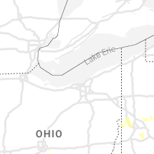
Hail Map for Wednesday, June 22, 2022

Number of Impacted Households on 6/22/2022
0
Impacted by 1" or Larger Hail
0
Impacted by 1.75" or Larger Hail
0
Impacted by 2.5" or Larger Hail
Square Miles of Populated Area Impacted on 6/22/2022
0
Impacted by 1" or Larger Hail
0
Impacted by 1.75" or Larger Hail
0
Impacted by 2.5" or Larger Hail


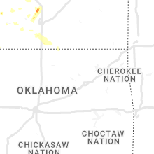

Cities Most Affected by Hail Storms of 6/22/2022
| Hail Size | Demographics of Zip Codes Affected | ||||||
|---|---|---|---|---|---|---|---|
| City | Count | Average | Largest | Pop Density | House Value | Income | Age |
| Sedgwick, KS | 1 | 1.75 | 1.75 | 26 | $74k | $46.9k | 39.8 |
Hail and Wind Damage Spotted on 6/22/2022
Filter by Report Type:Hail ReportsWind Reports
States Impacted
West Virginia, Virginia, Pennsylvania, New York, Maryland, Indiana, Ohio, Kentucky, Kansas, CaliforniaWest Virginia
| Local Time | Report Details |
|---|---|
| 9:35 AM EDT | Trees down along route 20 in hinton. time estimated from rada in summers county WV, 59.3 miles WNW of Roanoke, VA |
| 9:42 AM EDT | Multiple trees down between hilldale and talcott. time estimated from rada in summers county WV, 52.2 miles WNW of Roanoke, VA |
| 3:55 PM EDT | Quarter sized hail reported near Martinsburg, WV, 72.2 miles W of Baltimore, MD |
| 3:55 PM EDT | Numerous trees and wires blew down between charles town and shepherdstow in jefferson county WV, 65 miles W of Baltimore, MD |
| 3:55 PM EDT | Report of damage to trees and penny sized hail near the 470 block of gosling marsh r in berkeley county WV, 67.7 miles W of Baltimore, MD |
| 4:02 PM EDT | Numerous trees and wires blew down near the jefferson/loudoun county lin in jefferson county WV, 62.2 miles W of Baltimore, MD |
| 4:25 PM EDT | Numerous trees and wires blew down between charles town and shepherdstow in jefferson county WV, 65 miles W of Baltimore, MD |
| 4:38 PM EDT | A few trees blew down near the 2500 block of timber ridge r in morgan county WV, 89.4 miles W of Baltimore, MD |
| 4:49 PM EDT | A tree blew down near valley rd and fred michael l in morgan county WV, 90 miles ENE of Elkins, WV |
| 5:13 PM EDT | Tree down blocking intersectio in wood county WV, 69.3 miles N of Charleston, WV |
| 5:31 PM EDT | Tree dow in wood county WV, 67.2 miles N of Charleston, WV |
| 5:37 PM EDT | Corrects previous tstm wnd dmg report from 2 nne vienna. tree down blocking intersectio in wood county WV, 69.3 miles N of Charleston, WV |
| 5:37 PM EDT | Corrects previous tstm wnd dmg report from 2 nne vienna. tree down blocking intersectio in wood county WV, 69.3 miles N of Charleston, WV |
| 6:09 PM EDT | Tree dow in ritchie county WV, 64.7 miles NNE of Charleston, WV |
| 6:43 PM EDT | Preston county ema reported multiple trees down and a few damaged barn in preston county WV, 51.9 miles NNE of Elkins, WV |
| 7:20 PM EDT | Tree down on mcmullen hwy near dawso in allegany county MD, 61.9 miles NE of Elkins, WV |
| 7:23 PM EDT | Large tree down. mossman avenue close in mason county WV, 45.2 miles NW of Charleston, WV |
| 7:28 PM EDT | Several trees blown down in monongalia county WV, 51.1 miles N of Elkins, WV |
| 7:30 PM EDT | Trees reported blown down along chestnut ridge roa in monongalia county WV, 50.4 miles N of Elkins, WV |
| 7:32 PM EDT | Tree down blocking roa in wood county WV, 63.7 miles N of Charleston, WV |
| 7:32 PM EDT | Tree fell onto apartment comple in wood county WV, 65.1 miles N of Charleston, WV |
| 7:40 PM EDT | Trees snapped or uprooted in marion county WV, 45.2 miles NNW of Elkins, WV |
| 7:40 PM EDT | Trees reported blown down and one over powerlines along country club roa in marion county WV, 42.8 miles NNW of Elkins, WV |
| 7:41 PM EDT | A few trees down on horseshoe run roa in preston county WV, 29.9 miles NE of Elkins, WV |
| 7:41 PM EDT | Tree down across cumberland rd near potomac ave in hampshire county WV, 65.7 miles ENE of Elkins, WV |
| 7:47 PM EDT | Tree dow in nicholas county WV, 41.9 miles E of Charleston, WV |
| 7:50 PM EDT | Tree down along o brion roa in clay county WV, 40.1 miles ENE of Charleston, WV |
| 7:58 PM EDT | 2 trees dow in ritchie county WV, 64.7 miles NNE of Charleston, WV |
| 8:00 PM EDT | Tree blown down along irontown road in independenc in taylor county WV, 30.4 miles N of Elkins, WV |
| 8:05 PM EDT | Multiple trees down in grafton along sandy creek road... haymond road... plum run road... yates avenue... and victory avenu in taylor county WV, 30.4 miles NNW of Elkins, WV |
| 8:09 PM EDT | A few trees down on mountaineer highwa in tucker county WV, 17.8 miles N of Elkins, WV |
| 8:10 PM EDT | Trees down in on in cabell county WV, 30.9 miles W of Charleston, WV |
| 8:20 PM EDT | Multiple trees down along main street in hurrican in putnam county WV, 21.9 miles WNW of Charleston, WV |
| 8:30 PM EDT | Multple trees down throughout the city of charleston. a few roads along which trees fell include hickory road... sissonville drive... woodbridge drive... kanawha blvd in kanawha county WV, 0.6 miles W of Charleston, WV |
| 8:38 PM EDT | Quarter sized hail reported near Mount Nebo, WV, 44.1 miles ESE of Charleston, WV |
| 8:40 PM EDT | Tree blown down near alum cree in kanawha county WV, 9.5 miles SW of Charleston, WV |
| 8:44 PM EDT | Tree down near nicholas county line. time estimated from rada in greenbrier county WV, 53.9 miles ESE of Charleston, WV |
| 8:55 PM EDT | A tree and power lines were blown dow in kanawha county WV, 9.8 miles S of Charleston, WV |
| 9:10 PM EDT | Trees and power lines down in danville along price branch roa in boone county WV, 21.3 miles SSW of Charleston, WV |
| 9:10 PM EDT | Several trees down in nelli in boone county WV, 14.9 miles SSW of Charleston, WV |
| 9:35 PM EDT | Corrects previous tstm wnd dmg report from 1 ne hinton. trees down along route 20 in hinton. time estimated from rada in summers county WV, 59.3 miles WNW of Roanoke, VA |
| 9:42 PM EDT | Corrects previous tstm wnd dmg report from 1 wsw talcott. multiple trees down between hilldale and talcott. time estimated from rada in summers county WV, 52.2 miles WNW of Roanoke, VA |
Virginia
| Local Time | Report Details |
|---|---|
| 1:52 PM EDT | One large tree blew down near express dr and dawson beach r in prince william county VA, 55.5 miles SW of Baltimore, MD |
| 2:06 PM EDT | A tree blew down near the 180 block of ramoth church r in stafford county VA, 65.4 miles N of Richmond, VA |
| 2:06 PM EDT | Several large trees down near spotter's residence... causing damage to propert in stafford county VA, 65.9 miles N of Richmond, VA |
| 2:11 PM EDT | Tree down on kellog mill rd near mountain view rd in stafford county VA, 63.9 miles N of Richmond, VA |
| 2:11 PM EDT | Tree down in 700 block of kellog mill rd in stafford county VA, 63.1 miles N of Richmond, VA |
| 2:13 PM EDT | Storm damage reported in prince william county VA, 65.5 miles SW of Baltimore, MD |
| 2:18 PM EDT | A tree blew down near the 200 block of jett d in stafford county VA, 56 miles N of Richmond, VA |
| 2:22 PM EDT | Dozens of trees and wires blown down in the city of fredericksbur in city of fredericks county VA, 55.6 miles N of Richmond, VA |
| 2:24 PM EDT | Reports of large trees snapped... siding removed... and a shed shifted off its foundation in neighborhoods surrounding maury stadium in city of fredericks county VA, 55.8 miles N of Richmond, VA |
| 2:30 PM EDT | Dozens of trees... large tree limbs... and wires blew down over northeastern spotsylvania county... including along us-17 mills drive and va-636 mine roa in spotsylvania county VA, 51.1 miles N of Richmond, VA |
| 2:40 PM EDT | Large tree down on stonewall jackson roa in caroline county VA, 45.4 miles NNE of Richmond, VA |
| 2:40 PM EDT | Very large tree down blocking the entire road just south of the intersection of woodford road and fredericksburg turnpik in caroline county VA, 45.5 miles NNE of Richmond, VA |
| 2:40 PM EDT | Large tree down on vehicle on rozell road about one half mile from woodford roa in caroline county VA, 45.2 miles NNE of Richmond, VA |
| 2:55 PM EDT | Around 1...000 power outages clustered just to the west and southwest of bowling green. time estimated from rada in caroline county VA, 39.2 miles NNE of Richmond, VA |
| 3:04 PM EDT | Downed tree blocking jefferson davis highway near hillcrest driv in caroline county VA, 33.2 miles NNE of Richmond, VA |
| 3:10 PM EDT | Cluster of nearly 1...000 power outages a few miles west of beulahville. time estimate in king william county VA, 33.6 miles NE of Richmond, VA |
| 3:15 PM EDT | Numerous trees and wires down in hanover courthouse area. report from nwschat. time estimate in hanover county VA, 23.3 miles NE of Richmond, VA |
| 3:17 PM EDT | Numerous trees and wires down in ashland. report from nwschat. time estimate in hanover county VA, 19.8 miles NNE of Richmond, VA |
| 3:18 PM EDT | Multiple trees down on roadway near the intersection of new ashcake and sliding hill road. time estimate in hanover county VA, 18.2 miles NE of Richmond, VA |
| 3:28 PM EDT | Around 5...000 power outages due to storm between mechanicsville and studley. time estimate in hanover county VA, 17.3 miles ENE of Richmond, VA |
| 3:30 PM EDT | Report from mping: 1-inch tree limbs broken; shingles blown of in hanover county VA, 18.2 miles NE of Richmond, VA |
| 3:31 PM EDT | Report from mping: 1-inch tree limbs broken; shingles blown of in hanover county VA, 17.6 miles ENE of Richmond, VA |
| 3:32 PM EDT | Report from mping: 3-inch tree limbs broken; power poles broken. time estimated from rada in city of richmond county VA, 11.8 miles ENE of Richmond, VA |
| 3:32 PM EDT | Roof ripped off of apartment complex near arthur ashe blvd and broad st. time estimate in city of richmond county VA, 10.7 miles ENE of Richmond, VA |
| 3:35 PM EDT | Measured 60 mph gust at kri in henrico county VA, 18.2 miles E of Richmond, VA |
| 3:35 PM EDT | Numerous trees and wires down in the city of richmond. time estimate in city of richmond county VA, 13.1 miles ENE of Richmond, VA |
| 3:42 PM EDT | Tree down at the intersection of stonewall ave and w 20th street. time estimate in city of richmond county VA, 11.1 miles E of Richmond, VA |
| 3:42 PM EDT | Tree fell and smashed into a hom in city of richmond county VA, 13.9 miles E of Richmond, VA |
| 3:45 PM EDT | Tree down on home on swan drive. time estimate in chesterfield county VA, 8.8 miles ESE of Richmond, VA |
| 3:49 PM EDT | Multiple trees down at richmond highway and terminal avenue. time estimated from rada in city of richmond county VA, 11.7 miles E of Richmond, VA |
| 3:50 PM EDT | Tree down near the intersection of vauxhall and selwood road. time estimate in chesterfield county VA, 10.1 miles ESE of Richmond, VA |
| 3:54 PM EDT | Numerous trees down on woods edge road. time estimated from rada in chesterfield county VA, 19.2 miles SE of Richmond, VA |
| 3:54 PM EDT | Multiple trees down near howlett park. time estimate in chesterfield county VA, 14 miles SE of Richmond, VA |
| 3:54 PM EDT | Tree fell and punctured the roof of river view on the appomattox health and rehab cente in city of hopewell county VA, 23.9 miles SE of Richmond, VA |
| 3:58 PM EDT | Nearly 4...000 power outages due to storm in petersburg. time estimated from rada in city of petersburg county VA, 23.1 miles SE of Richmond, VA |
| 4:01 PM EDT | Tree down over route in loudoun county VA, 63.3 miles W of Baltimore, MD |
| 4:07 PM EDT | Tree down onto road at 3800 block of holsinger rd in rockingham county VA, 61.2 miles ESE of Elkins, WV |
| 4:07 PM EDT | Estimated wind gust of at least 50 knot in prince george county VA, 29.5 miles SSE of Richmond, VA |
| 4:10 PM EDT | Trees down on route 46 in prince george county VA, 35.9 miles SE of Richmond, VA |
| 4:10 PM EDT | Tree down onto powerline near intersection of phillips store rd and mayland rd in rockingham county VA, 62.4 miles ESE of Elkins, WV |
| 4:10 PM EDT | Trees and wires blew down near the intersection of va-259 maryland road and va-873 wentworth driv in rockingham county VA, 61.9 miles ESE of Elkins, WV |
| 4:10 PM EDT | A roof was torn from a house on va-619 wampler road near broadwa in rockingham county VA, 62.4 miles ESE of Elkins, WV |
| 4:12 PM EDT | Several large trees and several powerlines down along st. louis rd in loudoun county VA, 64.7 miles WSW of Baltimore, MD |
| 4:13 PM EDT | Tree down onto road near intersection of n valley pike and endless cavern rd in rockingham county VA, 65.5 miles ESE of Elkins, WV |
| 4:14 PM EDT | A tree blew down... blocking one lane of traffic... on hwy 50 one mile east of boyc in clarke county VA, 78 miles W of Baltimore, MD |
| 4:14 PM EDT | Nearly 2...000 power outages due to storm. this likely occurred with the passage of the gust front. time estimate in dinwiddie county VA, 24.9 miles SSE of Richmond, VA |
| 4:15 PM EDT | Trees down at mm 60 and mm 65 on interstate 85. time estimate in city of petersburg county VA, 24 miles SSE of Richmond, VA |
| 4:15 PM EDT | Tree down blocking roadway near intersection of n valley pike and llama l in rockingham county VA, 65 miles ESE of Elkins, WV |
| 4:15 PM EDT | Several trees blew down along va-723 millwood road between boyce and millwoo in clarke county VA, 78.6 miles W of Baltimore, MD |
| 4:15 PM EDT | Trees blew down along va-606 river road near bluemon in clarke county VA, 71.6 miles W of Baltimore, MD |
| 4:15 PM EDT | A few trees blew down along us-50 john mosby highway near blandy far in clarke county VA, 79.3 miles W of Baltimore, MD |
| 4:15 PM EDT | Numerous trees and branches down between middleburg and upperville in fauquier county VA, 68.5 miles WSW of Baltimore, MD |
| 4:20 PM EDT | Several trees blew down along va-649 frogtown roa in clarke county VA, 72.5 miles WSW of Baltimore, MD |
| 4:22 PM EDT | Over 200 power outages due to storm in carson. time estimated from rada in dinwiddie county VA, 35.3 miles SSE of Richmond, VA |
| 4:25 PM EDT | Dozens of trees blew down along i-66 near marshal in fauquier county VA, 71.5 miles WSW of Baltimore, MD |
| 4:30 PM EDT | Numerous trees blew down blocking us-17 winchester road near old taver in fauquier county VA, 72.4 miles WSW of Baltimore, MD |
| 4:30 PM EDT | Storm damage reported in page county VA, 80.1 miles ESE of Elkins, WV |
| 4:30 PM EDT | Tree down across shenandoah river rd at jr rd in page county VA, 72.1 miles ESE of Elkins, WV |
| 4:35 PM EDT | Numerous trees blew down blocking us-15/us-29 lee highway between warrenton and new baltimor in fauquier county VA, 71.8 miles WSW of Baltimore, MD |
| 4:40 PM EDT | Hundreds of trees blown down... many onto homes with at least 3 structure collapses over west-central fauquier count in fauquier county VA, 77 miles WSW of Baltimore, MD |
| 4:45 PM EDT | A couple dozen trees and wires blew down across the city of wincheste in city of winchester county VA, 84.1 miles W of Baltimore, MD |
| 4:45 PM EDT | Several trees and wires blew down around jeffersonto in culpeper county VA, 79.7 miles N of Richmond, VA |
| 4:45 PM EDT | Trees and wires blew down in the 2900 block of us-50 northwestern pik in frederick county VA, 87.2 miles W of Baltimore, MD |
| 4:47 PM EDT | Numerous trees down from 2 miles east of warrenton to opal on rt 2 in fauquier county VA, 77.4 miles N of Richmond, VA |
| 4:52 PM EDT | Numerous trees reported down in castleto in rappahannock county VA, 80.3 miles NNW of Richmond, VA |
| 4:54 PM EDT | A tree blew down on resettlement r in rappahannock county VA, 88.4 miles WSW of Baltimore, MD |
| 4:55 PM EDT | Several trees and wires blew down around rixeyvill in culpeper county VA, 76.2 miles NNW of Richmond, VA |
| 4:55 PM EDT | Several trees and wires blew down around amissvill in culpeper county VA, 81.1 miles NNW of Richmond, VA |
| 4:57 PM EDT | Tree down across spotswood trail near turkey ridge rd in greene county VA, 73.1 miles NW of Richmond, VA |
| 4:59 PM EDT | Numerous trees down around sperryvill in rappahannock county VA, 86.8 miles NNW of Richmond, VA |
| 5:00 PM EDT | A few trees blew down near white pos in clarke county VA, 83.5 miles WSW of Baltimore, MD |
| 5:00 PM EDT | Several trees and wires blew down around culpepe in culpeper county VA, 69.3 miles NNW of Richmond, VA |
| 5:05 PM EDT | Tree down across simmons gap rd near wildview lane in greene county VA, 72.7 miles NW of Richmond, VA |
| 5:05 PM EDT | Trees blew down near the intersection of va-631 marlboro road and va-628 middle roa in frederick county VA, 85 miles E of Elkins, WV |
| 5:10 PM EDT | Tree down across reliance rd at crooked run creek in warren county VA, 87.6 miles WSW of Baltimore, MD |
| 5:11 PM EDT | Tree reported down on ikes crossing lane near us 34 in page county VA, 80.5 miles E of Elkins, WV |
| 5:18 PM EDT | 3 to 4 trees dow in shenandoah county VA, 70.4 miles E of Elkins, WV |
| 5:20 PM EDT | A few trees blew down near rapida in orange county VA, 59.9 miles NNW of Richmond, VA |
| 5:25 PM EDT | A few trees blew down between zeus and brightwoo in madison county VA, 69.6 miles NNW of Richmond, VA |
| 5:29 PM EDT | Tree reported down on oak grove roa in madison county VA, 73.7 miles NNW of Richmond, VA |
| 5:34 PM EDT | About a dozen trees down south of st davids church on fort valley road towards the edinburg gap road intersectio in shenandoah county VA, 73.3 miles E of Elkins, WV |
| 5:39 PM EDT | Tree down across redman store rd just east of buisness us 340 in page county VA, 76.9 miles ESE of Elkins, WV |
| 6:04 PM EDT | Trees blew down near berryville and stringtown... including along va-611 summit point roa in clarke county VA, 72.7 miles W of Baltimore, MD |
| 6:12 PM EDT | Mesonet station xmgl middle ground ligh in anz638 county VA, 22.7 miles NW of Virginia Beach, VA |
| 6:19 PM EDT | Trees down in ivy in albemarle county VA, 64.6 miles NW of Richmond, VA |
| 6:33 PM EDT | Numerous trees down across the stanardsville area in greene county VA, 69.8 miles NW of Richmond, VA |
| 6:58 PM EDT | Tree down on va-20 in the county of buckingham... in the vicinity of copper mine r in buckingham county VA, 46.6 miles W of Richmond, VA |
| 7:02 PM EDT | One tree down on us-60 east in the county of buckingham... in the vicinity of alcoma r in buckingham county VA, 52.7 miles W of Richmond, VA |
| 7:04 PM EDT | Tree down along w james anderson hw in buckingham county VA, 53.8 miles W of Richmond, VA |
| 7:23 PM EDT | Winds from a gust front of a thunderstorm blew down one tree near the intersection of patrick henry highway and turkey mountain road and fletchers level roa in amherst county VA, 56.6 miles ENE of Roanoke, VA |
| 7:30 PM EDT | Winds from a gust front of a thunderstorm blew down one tree along the 1700 block of richmond highway and close to riverville roa in amherst county VA, 55.9 miles ENE of Roanoke, VA |
| 7:38 PM EDT | Tree down along red house road near richwood estates r in appomattox county VA, 61.2 miles E of Roanoke, VA |
| 7:39 PM EDT | Tree down on rt. 727 north... in the vicinity of cub creek r in appomattox county VA, 61.8 miles E of Roanoke, VA |
| 7:51 PM EDT | Large tree branches dow in campbell county VA, 49.2 miles E of Roanoke, VA |
| 7:52 PM EDT | Winds from a gust front of a thunderstorm blew down several trees near the intersection of sterrett road and north lee highwa in rockbridge county VA, 55.5 miles NE of Roanoke, VA |
| 7:59 PM EDT | Winds from a gust front of a thunderstorm blew down several trees near the intersection of maury river road and walkers creek roa in rockbridge county VA, 52.2 miles NNE of Roanoke, VA |
| 8:03 PM EDT | Tree down along juniper cliff road near hunter roa in campbell county VA, 56.6 miles ESE of Roanoke, VA |
| 8:25 PM EDT | One tree down on lennig roa in halifax county VA, 62.4 miles ESE of Roanoke, VA |
| 8:28 PM EDT | Two trees down on wolf gap road near the wv state lin in shenandoah county VA, 62.2 miles E of Elkins, WV |
| 8:41 PM EDT | Tree down along mt. laurel near green valley r in halifax county VA, 69.6 miles ESE of Roanoke, VA |
| 9:33 PM EDT | Power outages and trees down area-wide. larger power outage just to the ne of wise reported as the storm went throug in wise county VA, 32.6 miles NNW of Bristol, TN |
| 9:43 PM EDT | Large power outage with over 1000 customers without power near coebur in wise county VA, 27.4 miles NNW of Bristol, TN |
| 10:30 PM EDT | Tree down across peppers ferry roa in pulaski county VA, 39.8 miles WSW of Roanoke, VA |
Pennsylvania
| Local Time | Report Details |
|---|---|
| 2:50 PM EDT | Tree down across roa in franklin county PA, 58.9 miles NW of Baltimore, MD |
| 4:10 PM EDT | Trees down on woodward av in clinton county PA, 36.5 miles NE of State College, PA |
| 4:12 PM EDT | Trees and wires down on route 150 at deer field lan in clinton county PA, 35.3 miles NE of State College, PA |
| 4:15 PM EDT | Power lines down in beaver county PA, 22 miles NW of Pittsburgh, PA |
| 4:22 PM EDT | Wires down in beaver county PA, 17.8 miles NW of Pittsburgh, PA |
| 4:22 PM EDT | Large tree blocking roadway in butler county PA, 24.6 miles N of Pittsburgh, PA |
| 4:25 PM EDT | Report of trees and wires down along kane road. time estimated based on rada in beaver county PA, 18.2 miles NW of Pittsburgh, PA |
| 4:28 PM EDT | Trees and wires down on bocktown cork road in beaver county PA, 17.4 miles WNW of Pittsburgh, PA |
| 4:30 PM EDT | Two large trees down in allegheny county PA, 13.9 miles NNW of Pittsburgh, PA |
| 4:34 PM EDT | Multiple large trees down in allegheny county PA, 13.7 miles WNW of Pittsburgh, PA |
| 4:40 PM EDT | A few trees dow in forest county PA, 81.4 miles NNE of Pittsburgh, PA |
| 4:43 PM EDT | Trees down along college ave near the i-99 on ram in centre county PA, 9.5 miles NE of State College, PA |
| 4:50 PM EDT | Trees and wires blocking brush valley road west of centre hal in centre county PA, 7.1 miles ENE of State College, PA |
| 4:50 PM EDT | Trees snapped or uprooted in allegheny county PA, 17.9 miles NNE of Pittsburgh, PA |
| 4:52 PM EDT | Quarter sized hail reported near Centre Hall, PA, 7.4 miles E of State College, PA |
| 4:55 PM EDT | Trees snapped or uprooted in allegheny county PA, 5.7 miles WSW of Pittsburgh, PA |
| 4:57 PM EDT | Tree down in east allegheny in allegheny county PA, 1.5 miles NNE of Pittsburgh, PA |
| 4:58 PM EDT | Several trees down blocking roadway in allegheny county PA, 7.8 miles SSW of Pittsburgh, PA |
| 4:58 PM EDT | Report of medium sized tree felled along with other branches broken. time estimated based on rada in allegheny county PA, 5 miles ESE of Pittsburgh, PA |
| 5:00 PM EDT | Large tree limbs down in allegheny county PA, 2.9 miles SSW of Pittsburgh, PA |
| 5:01 PM EDT | Large tree limbs down and power poles broken in allegheny county PA, 3.5 miles SSW of Pittsburgh, PA |
| 5:01 PM EDT | Power lines down in allegheny county PA, 4.9 miles SSW of Pittsburgh, PA |
| 5:01 PM EDT | Power lines down in allegheny county PA, 5.5 miles SSW of Pittsburgh, PA |
| 5:02 PM EDT | Reports of wind-induced power outage in westmoreland county PA, 25.7 miles ESE of Pittsburgh, PA |
| 5:04 PM EDT | Several trees and wires down in allegheny county PA, 6.3 miles SSE of Pittsburgh, PA |
| 5:04 PM EDT | Power lines down in allegheny county PA, 5.4 miles S of Pittsburgh, PA |
| 5:08 PM EDT | Tree down at intersection of 9th / anchor ln in allegheny county PA, 18 miles NE of Pittsburgh, PA |
| 5:08 PM EDT | Report of large tree limb snapped along bownman avenue. time estimated based on rada in allegheny county PA, 10.4 miles ESE of Pittsburgh, PA |
| 5:10 PM EDT | Gas pump blown over in westmoreland county PA, 17.6 miles NE of Pittsburgh, PA |
| 5:10 PM EDT | Mobile home roof blew off in westmoreland county PA, 31.4 miles ESE of Pittsburgh, PA |
| 5:12 PM EDT | Several trees down in westmoreland county PA, 18 miles ENE of Pittsburgh, PA |
| 5:13 PM EDT | Report of tree snapped in half. time estimated based on rada in allegheny county PA, 18.9 miles NE of Pittsburgh, PA |
| 5:15 PM EDT | Trees down. time estimate based on radar in westmoreland county PA, 15.9 miles NE of Pittsburgh, PA |
| 5:20 PM EDT | Several large branches and a tree down in westmoreland county PA, 35.1 miles ESE of Pittsburgh, PA |
| 5:20 PM EDT | Report of large of trees down across unity township. time estimated based on rada in westmoreland county PA, 33.6 miles ESE of Pittsburgh, PA |
| 5:20 PM EDT | A few trees dow in clarion county PA, 54.5 miles NE of Pittsburgh, PA |
| 5:29 PM EDT | Trees down in westmoreland county PA, 18 miles ENE of Pittsburgh, PA |
| 5:30 PM EDT | Tree limbs down. tree down blocing potato garden run r in washington county PA, 18.1 miles W of Pittsburgh, PA |
| 5:30 PM EDT | Report of multiple large tree limbs snapped. time estimated based on rada in westmoreland county PA, 20.1 miles SSE of Pittsburgh, PA |
| 5:30 PM EDT | Report and pictures of multiple trees down and uprooted. time estimated based on rada in clarion county PA, 54.1 miles NE of Pittsburgh, PA |
| 5:35 PM EDT | Trees down on wires across bullitt roa in centre county PA, 15.8 miles NNE of State College, PA |
| 5:36 PM EDT | Trees down in westmoreland county PA, 24.3 miles ENE of Pittsburgh, PA |
| 5:47 PM EDT | Trees down on wire in elk county PA, 55.1 miles NW of State College, PA |
| 6:00 PM EDT | Large tree down blocking roadway on fulton lane in indiana county PA, 44.7 miles ENE of Pittsburgh, PA |
| 6:00 PM EDT | Trees down on graham and hilltop road in indiana county PA, 39.6 miles ENE of Pittsburgh, PA |
| 6:00 PM EDT | Report of downed light pole in armstrong county PA, 37.1 miles ENE of Pittsburgh, PA |
| 6:05 PM EDT | Trees blocking route 46 at old creek roa in cameron county PA, 58.1 miles NNW of State College, PA |
| 6:06 PM EDT | Tree limbs blown down in indiana county PA, 55.7 miles ENE of Pittsburgh, PA |
| 6:30 PM EDT | Trees down on wires near ursin in somerset county PA, 55.4 miles SE of Pittsburgh, PA |
| 6:32 PM EDT | Reports of wind-induced power outage in fayette county PA, 23 miles SSE of Pittsburgh, PA |
| 6:34 PM EDT | Trees down blocking philippi road at johnson road west of garret in somerset county PA, 62.9 miles SE of Pittsburgh, PA |
| 6:36 PM EDT | Trees down on wire in cambria county PA, 50.6 miles WSW of State College, PA |
| 6:42 PM EDT | Numerous trees on wires from south fork to summerhil in cambria county PA, 57 miles WSW of State College, PA |
| 6:42 PM EDT | Trees down on wire in cambria county PA, 58.3 miles E of Pittsburgh, PA |
| 6:46 PM EDT | Trees down on wires northeast of martinsbur in blair county PA, 40.3 miles SW of State College, PA |
| 7:03 PM EDT | Numerous trees and wires down along bethel hollow road near the gravity hil in bedford county PA, 64.3 miles SW of State College, PA |
| 7:19 PM EDT | Trees down on wire in bedford county PA, 62.9 miles SW of State College, PA |
| 7:21 PM EDT | Trees down on wire in bedford county PA, 63.7 miles SSW of State College, PA |
| 7:29 PM EDT | Numerous trees and wires down along route 2 in bedford county PA, 72.8 miles SSW of State College, PA |
New York
| Local Time | Report Details |
|---|---|
| 3:11 PM EDT | Trees and wires dow in erie county NY, 4.8 miles ESE of Buffalo, NY |
| 4:43 PM EDT | Trees dow in cattaraugus county NY, 37.7 miles SSE of Buffalo, NY |
Maryland
| Local Time | Report Details |
|---|---|
| 3:22 PM EDT | Several trees... wires and poles down in the haflway are in washington county MD, 66.1 miles WNW of Baltimore, MD |
| 3:25 PM EDT | Trees and wires down near the intersection of bolivar road and reno monument roa in frederick county MD, 54.3 miles WNW of Baltimore, MD |
| 7:00 PM EDT | Tree down on national trail at hemlock loop in garrett county MD, 61.8 miles NNE of Elkins, WV |
| 7:31 PM EDT | Two trees down in oldtow in allegany county MD, 78.7 miles ENE of Elkins, WV |
| 7:48 PM EDT | Two trees down on green ridge road ne near the mason-dixon lin in allegany county MD, 79.8 miles SSW of State College, PA |
Indiana
| Local Time | Report Details |
|---|---|
| 3:22 PM EDT | Uprooted tree of unknown size and health at this locatio in rush county IN, 48.8 miles ESE of Indianapolis, IN |
| 3:30 PM EDT | Several large branches down in the western part of franklin county. time estimated from rada in franklin county IN, 43.8 miles WNW of Cincinnati, OH |
| 3:42 PM EDT | Report of a tree down in lexington. time estimated from rada in scott county IN, 46 miles N of Louisville, KY |
| 3:47 PM EDT | Trees down on daisy hill r in clark county IN, 36.4 miles NNW of Louisville, KY |
| 3:50 PM EDT | Tree down across voyles r in floyd county IN, 30.9 miles NNW of Louisville, KY |
| 4:03 PM EDT | Trees down at intersection of us 31 and biggs r in clark county IN, 36.1 miles N of Louisville, KY |
| 4:10 PM EDT | Downed power line hanging over stree in clark county IN, 32 miles N of Louisville, KY |
| 4:10 PM EDT | Trees and large limbs down on sr 40 in clark county IN, 31.9 miles N of Louisville, KY |
| 4:20 PM EDT | Tree down on west s in floyd county IN, 22.6 miles NNW of Louisville, KY |
| 4:25 PM EDT | Tree down on hous in floyd county IN, 21.7 miles NNW of Louisville, KY |
| 4:25 PM EDT | Tree down on top of car on 111 in floyd county IN, 21.1 miles NNW of Louisville, KY |
| 4:57 PM EDT | Several large branches down. time estimated by rada in switzerland county IN, 23.9 miles SW of Cincinnati, OH |
Ohio
| Local Time | Report Details |
|---|---|
| 3:27 PM EDT | Some large branches and a small tree were downed near the intesection of hewitt avenue and whipp road. time estimated by rada in montgomery county OH, 43.1 miles NNE of Cincinnati, OH |
| 3:35 PM EDT | Numerous trees down across southern green county. time estimated from radar to be from 335 pm until about 345 p in greene county OH, 46.4 miles NE of Cincinnati, OH |
| 3:35 PM EDT | Trees down near the intersection of us35 and sr380. time estimated from rada in greene county OH, 49 miles NE of Cincinnati, OH |
| 4:00 PM EDT | A tree was doen on jack road near the intersection of phillips road. time estimated from rada in warren county OH, 28.3 miles NE of Cincinnati, OH |
| 4:00 PM EDT | A large tree fell through the top of a park building. time estimated by rada in butler county OH, 19.4 miles NNW of Cincinnati, OH |
| 4:03 PM EDT | Several trees down in ross township along hamilton cleves road. time estimated by rada in butler county OH, 16.8 miles NNW of Cincinnati, OH |
| 4:13 PM EDT | Large branhes down on wires. time estimated by rada in clinton county OH, 39.3 miles NE of Cincinnati, OH |
| 4:13 PM EDT | Two large healthy tree branches reported down. branches fell on wooden fence causing damage. time estimated from rada in clinton county OH, 39.8 miles NE of Cincinnati, OH |
| 4:27 PM EDT | A few trees were downed in whitewater township. time estimated by rada in hamilton county OH, 14.9 miles WNW of Cincinnati, OH |
| 4:27 PM EDT | Erroneous report from a previous day regarding damage in reading in hamilton county OH, 9.2 miles NNE of Cincinnati, OH |
| 4:50 PM EDT | Large tree limbs down in fairfield county OH, 13.3 miles ESE of Columbus, OH |
| 5:05 PM EDT | Tree down at intersectio in washington county OH, 76.9 miles ESE of Columbus, OH |
| 5:06 PM EDT | Tree reported down on secondary roa in jefferson county OH, 46.8 miles W of Pittsburgh, PA |
| 5:10 PM EDT | A few trees down across northern fairfield county. time estimated by rada in fairfield county OH, 24.5 miles ESE of Columbus, OH |
| 5:48 PM EDT | A tree was downed along russellville-winchester road. time estimated from rada in brown county OH, 43.3 miles ESE of Cincinnati, OH |
| 5:50 PM EDT | A couple of trees down on wires in the georgetown area.time estimated by rada in brown county OH, 36.4 miles ESE of Cincinnati, OH |
| 6:06 PM EDT | Tree dow in perry county OH, 46.4 miles ESE of Columbus, OH |
| 6:16 PM EDT | A few trees down along thomas hollow road. time estimated rom rada in scioto county OH, 74.6 miles S of Columbus, OH |
| 6:20 PM EDT | A few trees were downed along blue run township road. time estimated by rada in scioto county OH, 74.7 miles S of Columbus, OH |
| 6:20 PM EDT | Tree dow in vinton county OH, 63.2 miles SSE of Columbus, OH |
| 6:27 PM EDT | Tree dow in athens county OH, 66.2 miles SE of Columbus, OH |
| 6:27 PM EDT | Tree dow in athens county OH, 66.1 miles SE of Columbus, OH |
| 6:27 PM EDT | 5 trees down in the are in jackson county OH, 67.8 miles NW of Charleston, WV |
| 6:27 PM EDT | Tree dow in morgan county OH, 64.5 miles ESE of Columbus, OH |
| 6:33 PM EDT | 5 trees down in the are in jackson county OH, 67.8 miles NW of Charleston, WV |
| 6:35 PM EDT | Tree dow in vinton county OH, 63.2 miles SSE of Columbus, OH |
| 6:37 PM EDT | Tree dow in vinton county OH, 63.2 miles SSE of Columbus, OH |
| 6:42 PM EDT | A few trees down along careys run road. time estimated by rada in scioto county OH, 80.8 miles ESE of Cincinnati, OH |
| 6:45 PM EDT | Tree dow in vinton county OH, 63.2 miles SSE of Columbus, OH |
| 7:35 PM EDT | Tree dow in lawrence county OH, 46.6 miles WNW of Charleston, WV |
Kentucky
| Local Time | Report Details |
|---|---|
| 4:15 PM EDT | Trees down on rose island r in oldham county KY, 29 miles NNE of Louisville, KY |
| 4:21 PM EDT | Two trees down... one on a house and another on a car in carroll county KY, 46 miles SW of Cincinnati, OH |
| 4:25 PM EDT | Trees and powerlines down on the 5300 block of w hwy 52 in oldham county KY, 38 miles NNE of Louisville, KY |
| 4:26 PM EDT | Barn roof peeled of in oldham county KY, 36.5 miles NNE of Louisville, KY |
| 4:27 PM EDT | Trees down on grinstead dr near i-6 in jefferson county KY, 17.4 miles N of Louisville, KY |
| 4:27 PM EDT | Numerous trees down across the county in boone county KY, 13 miles WSW of Cincinnati, OH |
| 4:30 PM EDT | Tree down on hous in jefferson county KY, 14.9 miles NNW of Louisville, KY |
| 4:32 PM EDT | Report of trees and power lines down along bluegrass parkway. time estimated from rada in oldham county KY, 37.9 miles NNE of Louisville, KY |
| 4:35 PM EDT | Trees down on i-71s at exit 2 onto zorn avenue and on the va hospital propert in jefferson county KY, 19.5 miles N of Louisville, KY |
| 4:50 PM EDT | Report of a tree down across hudson lane near st. gabriel church. time estimated from rada in jefferson county KY, 14.1 miles NNE of Louisville, KY |
| 4:50 PM EDT | A few trees down in the warsaw area. time estimated by rada in gallatin county KY, 30.1 miles SW of Cincinnati, OH |
| 5:05 PM EDT | Trees in power lines on buck creek r in shelby county KY, 25.2 miles NE of Louisville, KY |
| 5:05 PM EDT | Trees in power lines on todds point r in shelby county KY, 26 miles NE of Louisville, KY |
| 5:15 PM EDT | Trees down on fox run r in shelby county KY, 33.3 miles NE of Louisville, KY |
| 5:17 PM EDT | Trees down at cropper rd and eminence pik in shelby county KY, 32.7 miles ENE of Louisville, KY |
| 5:30 PM EDT | A few trees were downed along state route 8. time estimated by rada in bracken county KY, 28.3 miles SE of Cincinnati, OH |
| 5:30 PM EDT | Trees down on back creek r in shelby county KY, 31.3 miles E of Louisville, KY |
| 5:30 PM EDT | Several trees down throughout pendleton county. time estimated by radar to have occured between 525 pm and 535 p in pendleton county KY, 31.6 miles SSE of Cincinnati, OH |
| 5:40 PM EDT | Tree down on ky hwy 1032 in harrison county KY, 40.9 miles S of Cincinnati, OH |
| 5:45 PM EDT | Tree down on state hwy 1284 in harrison county KY, 41.4 miles SSE of Cincinnati, OH |
| 5:53 PM EDT | Tree down on 62 in harrison county KY, 49.5 miles NNW of Irvine, KY |
| 5:55 PM EDT | Tree down at shadynook pike and shaw l in harrison county KY, 49.4 miles NNW of Irvine, KY |
| 5:55 PM EDT | Tress down on delaney ferry r in jessamine county KY, 41.2 miles WNW of Irvine, KY |
| 5:55 PM EDT | A few trees were downed along state route 10. time estimated by rada in bracken county KY, 41.8 miles SE of Cincinnati, OH |
| 5:55 PM EDT | Tree down on clear creek r in jessamine county KY, 40.7 miles WNW of Irvine, KY |
| 6:00 PM EDT | Several trees down... blocking multiple roads in mason county. this includes clarks run... kentucky route 8 and parker road. time estimated from radar to be between 555 in mason county KY, 45.9 miles SE of Cincinnati, OH |
| 6:05 PM EDT | Tree down on e union r in nicholas county KY, 42.1 miles N of Irvine, KY |
| 6:06 PM EDT | Trees down on bethany r in jessamine county KY, 32.3 miles WNW of Irvine, KY |
| 6:20 PM EDT | Several trees down in the tollesboro area. time estimated by rada in lewis county KY, 62.5 miles SE of Cincinnati, OH |
| 6:25 PM EDT | Multiple trees reported down at 3298 prewitt-grassy lick roa in montgomery county KY, 27 miles N of Irvine, KY |
| 6:25 PM EDT | Multiple trees reported down at 3991 grassy lick roa in montgomery county KY, 26.3 miles N of Irvine, KY |
| 6:25 PM EDT | Tree reported down at the intersection of midland trail and hinkston pik in montgomery county KY, 26.3 miles N of Irvine, KY |
| 6:30 PM EDT | 911 center reported a tree was down on levee road bypass. the tree was on an electric line but power did not go out. time estimated from radar and observation in mount in montgomery county KY, 23.5 miles N of Irvine, KY |
| 6:30 PM EDT | Tree reported down at the intersection of howards mill road and stepstone mill roa in montgomery county KY, 26.5 miles N of Irvine, KY |
| 6:30 PM EDT | Tree reported down on 210 rogers avenu in montgomery county KY, 24.9 miles N of Irvine, KY |
| 6:35 PM EDT | Tree reported down on 1675 fogg pik in montgomery county KY, 22.8 miles N of Irvine, KY |
| 6:35 PM EDT | Tree reported down at the intersection of stepstone and turley roa in montgomery county KY, 27.5 miles NNE of Irvine, KY |
| 6:35 PM EDT | A tree was reported down at 1342 indian mound drive. the tree fell on an electric line... but power was not out. time estimated from radar and observation in mount ster in montgomery county KY, 24.2 miles N of Irvine, KY |
| 6:55 PM EDT | Tree reported down along ky-11 in bath county KY, 38.7 miles NNE of Irvine, KY |
| 7:00 PM EDT | Tree reported down on ky-60 just outside salt lic in bath county KY, 35.1 miles NNE of Irvine, KY |
| 7:06 PM EDT | Tree reported down near the 1900 block of pilot road in stanton... ky. time estimated via rada in powell county KY, 12 miles ENE of Irvine, KY |
| 7:07 PM EDT | Tree dow in greenup county KY, 72.3 miles WNW of Charleston, WV |
| 6:08 PM CDT | Power lines dow in adair county KY, 72.7 miles SSE of Louisville, KY |
| 7:08 PM EDT | Received report from 911 dispatch stating multiple trees were down on glencarin road in rogers... ky. time estimated from rada in wolfe county KY, 18.7 miles E of Irvine, KY |
| 7:08 PM EDT | Report from 911 dispatch stating a tree came down on hiram branch road. the tree fell on a power line... taking out power to nearby customers. time estimated from radar in wolfe county KY, 24.7 miles E of Irvine, KY |
| 7:10 PM EDT | Corrects previous tstm wnd dmg report from 2 se stanton. tree reported down at the 2000 block of furnace road in stanton... ky. time estimated via rada in powell county KY, 11.6 miles NE of Irvine, KY |
| 7:12 PM EDT | Report from 911 dispatch stating a tree was down on calaboose ridge road. time estimated from rada in wolfe county KY, 24.4 miles ENE of Irvine, KY |
| 7:12 PM EDT | Received report on social media of four trees down and blocking the road near exit 48 on the mountain parkway. time estimated from rada in wolfe county KY, 27.3 miles E of Irvine, KY |
| 6:15 PM CDT | Trees dow in adair county KY, 63.4 miles SSE of Louisville, KY |
| 7:28 PM EDT | A large tree limb was blown down onto stamper branc in wolfe county KY, 29.2 miles ENE of Irvine, KY |
| 7:35 PM EDT | Tree down on hwy 19 in morgan county KY, 40.4 miles ENE of Irvine, KY |
| 7:40 PM EDT | Tree down on hwy 100 in morgan county KY, 42.8 miles ENE of Irvine, KY |
| 6:43 PM CDT | Branch fell on camper...two people inside were extricated by ems. unknown if any injuries. also...one tree down in tow in russell county KY, 73.3 miles SSE of Louisville, KY |
| 8:10 PM EDT | Tree down on bowlin roa in wayne county KY, 80.5 miles NW of Knoxville, TN |
| 8:40 PM EDT | Powerline down near the dollar general on cutshin road. power outages have been reported throughout the surrounding are in leslie county KY, 52.6 miles SE of Irvine, KY |
| 8:45 PM EDT | Tree down on ky-7. time estimated by rada in perry county KY, 60.9 miles SE of Irvine, KY |
| 8:45 PM EDT | Tree down on right fork maces creek roa in perry county KY, 57.4 miles SE of Irvine, KY |
| 9:05 PM EDT | Tree fell on a house on parker stree in harlan county KY, 50.3 miles WNW of Bristol, TN |
| 10:33 PM EDT | Tree reported down at the 2000 block of furnace road in stanton... ky. time estimated via rada in powell county KY, 11.6 miles NE of Irvine, KY |
Kansas
| Local Time | Report Details |
|---|---|
| 4:00 PM CDT | Est. 70-75 mph wind in sumner county KS, 29 miles S of Wichita, KS |
| 4:02 PM CDT | Dime size hail and 60 mph winds reported just east of wellingto in sumner county KS, 28.2 miles S of Wichita, KS |
| 4:16 PM CDT | Delayed report... strong straight-line winds out of the east. cars and trucks shaking and pulled over on i-35. estimated 60-70 mph wind in sumner county KS, 28.1 miles S of Wichita, KS |
| 4:30 PM CDT | Quarter sized hail reported near Andale, KS, 17.6 miles WNW of Wichita, KS, delayed report. was accompanied by 70 to 80 mph winds. |
| 4:30 PM CDT | Delayed report. quite a bit of damage in the andale area... including some fences and trees blown down... along with a damaged light pole. an air conditioner was moved in sedgwick county KS, 17.6 miles WNW of Wichita, KS |
| 4:35 PM CDT | Has nickel and quarter sized hail... e70 mph wind. tree limbs down and damage light pole in sedgwick county KS, 17.6 miles WNW of Wichita, KS |
| 4:53 PM CDT | City of bentley police chief reported they had ping pong ball sized hail and estimated 70 mph straight line winds. damaged to 4 houses with both roof and window damag in sedgwick county KS, 17.3 miles NW of Wichita, KS |
| 4:55 PM CDT | Multiple limbs ... power poles damaged and lines down in several places. time est. based on rada in sedgwick county KS, 17.3 miles NW of Wichita, KS |
| 5:00 PM CDT | Golf Ball sized hail reported near Sedgwick, KS, 17.3 miles NW of Wichita, KS, social media images. |
| 5:05 PM CDT | Sig. tree damage via social medi in sedgwick county KS, 16.4 miles NNW of Wichita, KS |
| 5:05 PM CDT | Damage to house roof and barn roof... time est. based on rada in harvey county KS, 17.4 miles NNW of Wichita, KS |
| 5:10 PM CDT | Ping Pong Ball sized hail reported near Halstead, KS, 23.8 miles NNW of Wichita, KS, ping pong ball sized hail and significant tree limbs down. |
| 5:30 PM CDT | Quarter sized hail reported near Newton, KS, 24.4 miles N of Wichita, KS, also reported 60mph winds. |
| 5:33 PM CDT | Delayed report. very large tree down via social media. time est based on rada in sedgwick county KS, 16.6 miles WNW of Wichita, KS |
| 5:46 PM CDT | Half Dollar sized hail reported near Sedgwick, KS, 17.3 miles NW of Wichita, KS, corrects previous hail report from bentley. 1 to 1.25 inch hail. lots of tree limbs broken... power pole damage & lines down. |
| 5:46 PM CDT | Ping Pong Ball sized hail reported near Sedgwick, KS, 17.3 miles NW of Wichita, KS, 1 to 1.5 inch hail. |
| 6:00 PM CDT | Power pole and tree downe in pratt county KS, 78.6 miles W of Wichita, KS |
| 6:03 PM CDT | Semi trailer blown ove in kiowa county KS, 83.4 miles N of Woodward, OK |
| 8:01 PM CDT | Mesonet station ur350 4.4 ne hayne (upr in seward county KS, 56.9 miles S of Garden City, KS |
| 9:02 PM CDT | Storm damage reported in meade county KS, 53.2 miles SSE of Garden City, KS |
California
| Local Time | Report Details |
|---|---|
| 3:53 PM PDT | Wind gust to 69mph measured in moore... c in san bernardino county CA, 52.3 miles S of Las Vegas, NV |
| 9:27 PM PDT | Correct mesonet station is pcec in fresno county CA, 54.6 miles W of Fresno, CA |
Connect with Interactive Hail Maps