

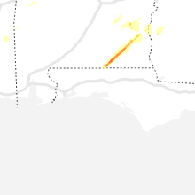
Hail Map for Wednesday, March 4, 2020

Number of Impacted Households on 3/4/2020
0
Impacted by 1" or Larger Hail
0
Impacted by 1.75" or Larger Hail
0
Impacted by 2.5" or Larger Hail
Square Miles of Populated Area Impacted on 3/4/2020
0
Impacted by 1" or Larger Hail
0
Impacted by 1.75" or Larger Hail
0
Impacted by 2.5" or Larger Hail


Cities Most Affected by Hail Storms of 3/4/2020
| Hail Size | Demographics of Zip Codes Affected | ||||||
|---|---|---|---|---|---|---|---|
| City | Count | Average | Largest | Pop Density | House Value | Income | Age |
| Brandon, MS | 2 | 1.88 | 2.00 | 154 | $110k | $47.9k | 37.7 |
| Terry, MS | 1 | 1.75 | 1.75 | 92 | $112k | $46.4k | 43.6 |
| Byram, MS | 1 | 1.75 | 1.75 | 636 | $0k | $0.0k | 32.4 |
| Samson, AL | 1 | 1.75 | 1.75 | 31 | $49k | $24.0k | 40.8 |
Hail and Wind Damage Spotted on 3/4/2020
Filter by Report Type:Hail ReportsWind Reports
Alabama
| Local Time | Report Details |
|---|---|
| 6:01 AM CST | Corrects previous tstm wnd dmg report from 1 wsw sellers. trees down on hickory grove rd... near hwy 331 sout in montgomery county AL, 58.3 miles E of Camden, AL |
| 6:05 AM CST | Several trees and a few power lines down in the highland home and panola area in crenshaw county AL, 57 miles E of Camden, AL |
| 6:20 AM CST | Trees down near jordan rd and bradleyton r in crenshaw county AL, 61.5 miles E of Camden, AL |
| 6:41 AM CST | 59mph wind gust recorded by toi asos at 641am. multiple reports of trees on roadways near the city of troy and the airport. more details to com in pike county AL, 60.1 miles SSW of Auburn, AL |
| 6:45 AM CST | Per the city of troy... large tree and power pole down along pell ave... resulting in power outages around troy universit in pike county AL, 62 miles SSW of Auburn, AL |
| 6:50 AM CST | Trees down on county road in bullock county AL, 47.5 miles SSW of Auburn, AL |
| 6:54 AM CST | Trees down on highway 29 south in perote community. time estimate in bullock county AL, 47.2 miles SSW of Auburn, AL |
| 7:02 AM CST | Tree blocking highway 239 near barbour/bullock county line. time estimate in bullock county AL, 46 miles S of Auburn, AL |
| 7:04 AM CST | Tree down off cr-35 near us-82. time estimate in bullock county AL, 37 miles S of Auburn, AL |
| 7:07 AM CST | Trees down on highway 29 in the perote community... and on highway 239 near the pea river... causing the bridge to be close in bullock county AL, 46 miles S of Auburn, AL |
| 7:56 AM CST | Multiple trees uprooted. pictures via social medi in escambia county AL, 52.5 miles ENE of Mobile, AL |
| 8:08 AM CST | Public report via facebook of a tree snapped along furnie folks roa in houston county AL, 81.5 miles NW of Tallahassee, FL |
| 8:10 AM CST | Multiple trees and power lines down on belleville ave and evergreen ave in brewton. few homes with roof damage. time estimated by radar and report via social medi in escambia county AL, 62.2 miles SSE of Camden, AL |
| 8:20 AM CST | Reports of a tree on a car... damage to houses and a sports complex... multiple reports of trees down near new brockton and elb in coffee county AL, 74 miles NNE of Miramar Beach, FL |
| 8:45 AM CST | Several trees down and roof off home near newto in dale county AL, 80.4 miles NE of Miramar Beach, FL |
| 8:52 AM CST | Power lines down on county road 112 as well as a railroad crossing gate dow in dale county AL, 84.4 miles NE of Miramar Beach, FL |
| 8:52 AM CST | Power lines down on county road 112 as well as a railroad crossing gate dow in dale county AL, 84.4 miles NE of Miramar Beach, FL |
| 9:08 AM CST | Corrects time of previous tstm wnd dmg report from 2 sw webb. public report via facebook of a tree snapped along furnie folks roa in houston county AL, 81.5 miles NW of Tallahassee, FL |
| 4:24 AM CST | Golf Ball sized hail reported near Samson, AL, 54.5 miles NNE of Miramar Beach, FL |
| 5:00 AM CST | Quarter sized hail reported near Skipperville, AL, 72.2 miles S of Auburn, AL, picture of quarter size hail on social media via wtvm. |
Louisiana
| Local Time | Report Details |
|---|---|
| 6:18 AM CST | Quarter sized hail reported near Shreveport, LA, 3.1 miles S of Shreveport, LA, report from mping: quarter (1.00 in.). |
| 7:43 AM CST | Quarter sized hail reported near Stonewall, LA, 16 miles SSW of Shreveport, LA, video was posted to facebook of quarter size hail falling at the red river bank in stonewall. |
| 7:45 AM CST | Quarter sized hail reported near Gloster, LA, 22.8 miles S of Shreveport, LA, a picture was posted to social media of quarter size hail that fell in the gloster community. |
| 7:45 AM CST | Quarter sized hail reported near Keithville, LA, 11.9 miles SSW of Shreveport, LA, penny to quarter size hail fell along barron road in keithville. |
| 7:52 AM CST | Quarter sized hail reported near Stonewall, LA, 16.5 miles S of Shreveport, LA, one inch hail reported in the stonewall vicinity. |
| 7:53 AM CST | Quarter sized hail reported near Shreveport, LA, 7.9 miles S of Shreveport, LA, dime to quarter size hail fell at brookwood baptist church. |
Texas
| Local Time | Report Details |
|---|---|
| 6:45 AM CST | Quarter sized hail reported near Jacksonville, TX, 53.6 miles NW of Lufkin, TX, quarter size hail fell at the intersection of highway 69 and 79 in jacksonville. report from facebook. |
| 6:50 AM CST | Quarter sized hail reported near Henderson, TX, 48.1 miles N of Lufkin, TX, one inch hail reported along hwy 259 between mount enterprise and henderson... texas. |
| 6:52 AM CST | Quarter sized hail reported near Jacksonville, TX, 51.7 miles NW of Lufkin, TX, one inch hail reported at exxon gas station on hwy 69 southeast of jacksonville. |
| 6:57 AM CST | Trees were downed on fm 840 a couple of miles from henderson which forced the closure of the roa in rusk county TX, 55 miles N of Lufkin, TX |
| 7:05 AM CST | Small radio tower blown down and scattered tree damage east of lake striker and along farm road 83 in rusk county TX, 43.8 miles NNW of Lufkin, TX |
| 7:05 AM CST | Trees reported down and roof damage to home roof near fm 2274 and fm 235 reported from reklaw vf in cherokee county TX, 46 miles NNW of Lufkin, TX |
| 7:07 AM CST | Multiple trees down. roof removed from a pier at lake striker resort. pier was destroye in rusk county TX, 44 miles NNW of Lufkin, TX |
| 7:10 AM CST | Tree or large limb on home east of lake striker in sw county near new salem... no injuries reported at this tim in rusk county TX, 46 miles NNW of Lufkin, TX |
| 7:24 AM CST | Cherokee sheriff office reports trees down all over the northern part of the count in cherokee county TX, 49.1 miles NNW of Lufkin, TX |
| 7:30 AM CST | Tree down us 84 and cr 3167. outside of mount enterpris in rusk county TX, 55.8 miles N of Lufkin, TX |
| 7:30 AM CST | Sheriff office reports over 25 trees down across central and south rusk count in rusk county TX, 56.5 miles N of Lufkin, TX |
| 8:35 AM CST | Projects for a theme park were destroyed at a property in the gause area. an 88 ft and 32 ft prop were destroyed. silos were also moved on the propert in milam county TX, 67.1 miles ESE of Killeen, TX |
| 9:09 AM CST | Quarter sized hail reported near Bryan, TX, 80.8 miles ESE of Killeen, TX |
| 9:10 AM CST | Quarter sized hail reported near Bryan, TX, 77 miles ESE of Killeen, TX, nws hgx relayed a report of 1" hail 10 nw of bryan... or about 3 nw of benchley |
| 9:14 AM CST | Measured with a hand held anemomete in brazos county TX, 81.8 miles ESE of Killeen, TX |
Georgia
| Local Time | Report Details |
|---|---|
| 8:49 AM EST | Downed trees with some trees on powerlines across northern half of clay count in clay county GA, 65.8 miles SSE of Auburn, AL |
| 8:50 AM EST | Report of some siding blown off a buildin in clay county GA, 61.9 miles SSE of Auburn, AL |
| 9:10 AM EST | Multiple reports of trees and power lines down across the western part of the count in randolph county GA, 70.3 miles SE of Auburn, AL |
| 9:10 AM EST | *** 1 inj *** multiple homes with trees on them... trees and power lines down all over the cit in randolph county GA, 70.5 miles SE of Auburn, AL |
| 9:58 AM EST | Tree through a home near graves spring roa in lee county GA, 74.9 miles W of Douglas, GA |
| 10:20 AM EST | Tree down at 200 smoak bridge circle in the warwick are in worth county GA, 66.9 miles WNW of Douglas, GA |
| 10:33 AM EST | Tree down block the road on mays mill roa in early county GA, 71.6 miles NNW of Tallahassee, FL |
| 10:35 AM EST | Tree down along cedar springs roa in early county GA, 70.5 miles NW of Tallahassee, FL |
| 10:42 AM EST | A few trees down south of baxle in appling county GA, 32.4 miles ENE of Douglas, GA |
| 11:02 AM EST | Traffic light down and power line damaged. time estimated by rada in liberty county GA, 27.8 miles SW of Savannah, GA |
| 11:02 AM EST | Power line down on hwy 17 near chemical plant r in liberty county GA, 30.7 miles SW of Savannah, GA |
| 11:07 AM EST | A trained spotter reported a tree down near the intersection of hwy 17 and 84. time estimated via radar dat in liberty county GA, 27.8 miles SW of Savannah, GA |
| 11:10 AM EST | A few trees down in wayne count in wayne county GA, 42.5 miles E of Douglas, GA |
| 11:14 AM EST | A trained spotter reported a tree down blocking part of the right lane on hwy 17 near riceboro. time estimated via radar dat in liberty county GA, 31.2 miles SW of Savannah, GA |
Mississippi
| Local Time | Report Details |
|---|---|
| 9:53 AM CST | Quarter sized hail reported near Terry, MS, 11.6 miles SW of Jackson, MS, hail up to the size of quarters west of byram reported via mping. |
| 9:55 AM CST | Golf Ball sized hail reported near Terry, MS, 15.4 miles SSW of Jackson, MS, hail up to the size of golf balls was falling along interstate 55 near terry. small limbs and quickly ponding water were also on the road. |
| 9:57 AM CST | Golf Ball sized hail reported near Byram, MS, 8.8 miles SSW of Jackson, MS, golf ball size hail was falling in byram. |
| 10:00 AM CST | Quarter sized hail reported near Florence, MS, 9.6 miles S of Jackson, MS, hail up to the size of quarters fell in the cleary heights community. report with video relayed via twitter. |
| 10:07 AM CST | Quarter sized hail reported near Pearl, MS, 6.3 miles ESE of Jackson, MS, hail up to the size of quarters fell at the mississippi emergency management agency office. |
| 10:08 AM CST | Quarter sized hail reported near Whitfield, MS, 7.6 miles ESE of Jackson, MS, hail up to the size of quarters was falling at the mississippi state hospital. |
| 10:08 AM CST | Half Dollar sized hail reported near Richland, MS, 5.7 miles SSE of Jackson, MS, hail to slightly larger than quarter size fell in richland. |
| 10:08 AM CST | Ping Pong Ball sized hail reported near Pearl, MS, 8.9 miles SE of Jackson, MS, 1.5 inch hail fell east of richland. |
| 10:14 AM CST | Quarter sized hail reported near Brandon, MS, 13.8 miles ESE of Jackson, MS, dime to quarter size hail was falling in the robinhood neighborhood. report with video relayed via twitter. |
| 10:15 AM CST | Quarter sized hail reported near Brandon, MS, 12.4 miles ESE of Jackson, MS, hail of nickel up to quarter size was falling at brandon high school. |
| 10:20 AM CST | Hen Egg sized hail reported near Brandon, MS, 17 miles ESE of Jackson, MS, public report of 2 inch hail near shell oil rd and hwy 18. |
| 10:22 AM CST | Quarter sized hail reported near Brandon, MS, 18.8 miles ESE of Jackson, MS, hail up to the size of quarters was beginning to fall along shiloh road east of brandon. |
| 10:24 AM CST | Golf Ball sized hail reported near Brandon, MS, 18.8 miles ESE of Jackson, MS, hail up to the size of golf balls began falling along shiloh road east of brandon. |
| 11:45 AM CST | A tree was blown down onto county road 420 near the lauderdale county line. time estimated from rada in clarke county MS, 71.3 miles W of Camden, AL |
Montana
| Local Time | Report Details |
|---|---|
| 11:30 AM MST | Storm damage reported in wheatland county MT, 77.3 miles NW of Billings, MT |
| 12:00 PM MST | Storm damage reported in stillwater county MT, 52.4 miles WSW of Billings, MT |
North Dakota
| Local Time | Report Details |
|---|---|
| 2:30 PM MST | Time estimated by rada in hettinger county ND, 68 miles WSW of Bismarck, ND |
Connect with Interactive Hail Maps