

Hail Map for Saturday, March 5, 2022

Number of Impacted Households on 3/5/2022
0
Impacted by 1" or Larger Hail
0
Impacted by 1.75" or Larger Hail
0
Impacted by 2.5" or Larger Hail
Square Miles of Populated Area Impacted on 3/5/2022
0
Impacted by 1" or Larger Hail
0
Impacted by 1.75" or Larger Hail
0
Impacted by 2.5" or Larger Hail


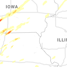


Cities Most Affected by Hail Storms of 3/5/2022
| Hail Size | Demographics of Zip Codes Affected | ||||||
|---|---|---|---|---|---|---|---|
| City | Count | Average | Largest | Pop Density | House Value | Income | Age |
| Orient, IA | 5 | 2.20 | 2.75 | 7 | $54k | $38.8k | 42.6 |
| Pleasant Hill, IA | 1 | 2.50 | 2.50 | 578 | $0k | $0.0k | 36.4 |
| Prescott, IA | 1 | 1.75 | 1.75 | 6 | $23k | $35.2k | 46.5 |
| Milan, MO | 1 | 1.75 | 1.75 | 15 | $45k | $26.1k | 38.0 |
Hail and Wind Damage Spotted on 3/5/2022
Filter by Report Type:Hail ReportsWind Reports
Illinois
| Local Time | Report Details |
|---|---|
| 11:50 AM CST | Power transformers down. relayed via broadcast media. time estimated from rada in champaign county IL, 57.6 miles NNE of Mattoon, IL |
| 8:48 PM CST | Aso in rock island county IL, 70.7 miles ESE of Cedar Rapids, IA |
| 8:50 PM CST | Also pea sized hai in rock island county IL, 68.5 miles ESE of Cedar Rapids, IA |
| 8:50 PM CST | Corrects previous tstm wnd dmg report from 1 wnw aled in mercer county IL, 70.6 miles WNW of Peoria, IL |
| 8:56 PM CST | Quincy airport aso in adams county IL, 43.4 miles SE of Kahoka, MO |
| 9:22 PM CST | Storm damage reported in carroll county IL, 73.7 miles SSW of Madison, WI |
| 9:28 PM CST | From hand-held anemomete in henry county IL, 63.7 miles NNW of Peoria, IL |
| 9:34 PM CST | Awo in whiteside county IL, 73.2 miles N of Peoria, IL |
| 9:35 PM CST | Storm damage reported in brown county IL, 57 miles ESE of Kahoka, MO |
| 9:37 PM CST | Time estimated from radar. trees down along dixon roa in whiteside county IL, 74.4 miles N of Peoria, IL |
| 9:55 PM CST | Storm damage reported in stephenson county IL, 57.6 miles S of Madison, WI |
| 10:15 PM CST | Krfd asos peak gus in winnebago county IL, 62 miles SSE of Madison, WI |
| 10:25 PM CST | Semi truck blown over on route 72 east of genoa. time estimated from rada in de kalb county IL, 53.5 miles WNW of Chicago, IL |
| 10:35 PM CST | Kvys awos peak gus in la salle county IL, 50.8 miles NNE of Peoria, IL |
| 10:35 PM CST | Peak gust from weatherbug station in harvar in mchenry county IL, 59.6 miles SE of Madison, WI |
| 10:36 PM CST | Measured at tazewell county eo in tazewell county IL, 12.3 miles SSE of Peoria, IL |
| 10:43 PM CST | Asos station kspi springfield capital a in sangamon county IL, 58.3 miles S of Peoria, IL |
| 10:44 PM CST | 8-inch diameter tree limb downed. time estimated from rada in mchenry county IL, 39.3 miles WNW of Chicago, IL |
| 10:45 PM CST | Karr asos peak gus in kane county IL, 43.9 miles W of Chicago, IL |
| 10:52 PM CST | Semi blown over on i-55 just north of waggoner at mile marker 6 in montgomery county IL, 60.6 miles NNE of Saint Louis, MO |
| 10:55 PM CST | Kdpa asos peak gus in dupage county IL, 32.4 miles W of Chicago, IL |
| 11:00 PM CST | Measured on personal weather statio in lake county IL, 47.6 miles NNW of Chicago, IL |
| 11:11 PM CST | Kpwk asos peak gus in cook county IL, 21.3 miles NW of Chicago, IL |
| 11:12 PM CST | Kugn asos peak gus in lake county IL, 38.9 miles NNW of Chicago, IL |
| 11:13 PM CST | Kord asos peak gus in cook county IL, 15.3 miles WNW of Chicago, IL |
| 11:14 PM CST | Estimated 50-60 mph wind gusts in elk grove villag in cook county IL, 21 miles WNW of Chicago, IL |
| 11:15 PM CST | Awos station ktaz taylorville muni a in christian county IL, 51.1 miles W of Mattoon, IL |
| 11:17 PM CST | Photo shared on social media showing part of an apartment complex roof peeled back. time estimated from rada in cook county IL, 10.2 miles WNW of Chicago, IL |
| 11:20 PM CST | Large tree limb downed onto road. time estimated from rada in cook county IL, 13.2 miles NW of Chicago, IL |
| 11:21 PM CST | Estimated peak wind gus in lake county IL, 23.6 miles NNW of Chicago, IL |
| 11:26 PM CST | Kmdw asos peak gus in cook county IL, 8.9 miles SW of Chicago, IL |
| 11:38 PM CST | Asos station kdec decatur a in macon county IL, 34.9 miles NW of Mattoon, IL |
| 11:50 PM CST | Corrects previous tstm wnd dmg report from rantoul. power transformers down. relayed via broadcast media. time estimated from rada in champaign county IL, 57.6 miles NNE of Mattoon, IL |
| 12:35 AM CST | Storm damage reported in vermilion county IL, 46.2 miles NE of Mattoon, IL |
| 12:35 AM CST | Storm damage reported in vermilion county IL, 64.5 miles NE of Mattoon, IL |
Iowa
| Local Time | Report Details |
|---|---|
| 2:06 PM CST | Quarter sized hail reported near Marshalltown, IA, 41.6 miles NE of Des Moines, IA, social media picture of quarter size hail. |
| 3:01 PM CST | Powerlines down and outbuilding destroye in mills county IA, 33.5 miles ESE of Omaha, NE |
| 3:15 PM CST | Quarter sized hail reported near Essex, IA, 49.6 miles SE of Omaha, NE, report from mping: quarter (1.00 in.). |
| 3:16 PM CST | Damage to roof and flipped trampolin in mills county IA, 33.5 miles ESE of Omaha, NE |
| 3:42 PM CST | Half Dollar sized hail reported near Nodaway, IA, 59.9 miles ESE of Omaha, NE, quarter to ping pong sized hail reported southeast of nodaway... iowa. |
| 3:54 PM CST | Ping Pong Ball sized hail reported near Orient, IA, 51.9 miles WSW of Des Moines, IA, hail report of 1.5 inches west of orient... iowa via spotternetwork sn#52257. |
| 3:55 PM CST | Golf Ball sized hail reported near Prescott, IA, 60.9 miles SW of Des Moines, IA, hail report of 1.75 inches north of prescott... iowa via spotternetwork sn#52258. |
| 4:06 PM CST | Quarter sized hail reported near Orient, IA, 52.8 miles WSW of Des Moines, IA, hail report of 1 inch via spotternetwork w of orient sn#52260. |
| 4:08 PM CST | Golf Ball sized hail reported near Orient, IA, 51.8 miles WSW of Des Moines, IA, report from mping: golf ball (1.75 in.). |
| 4:13 PM CST | Tennis Ball sized hail reported near Orient, IA, 46.3 miles WSW of Des Moines, IA, spotter report of ongoing tennis ball hail east northeast of orient. |
| 4:19 PM CST | Hen Egg sized hail reported near Orient, IA, 49.8 miles WSW of Des Moines, IA, 2+ inch hail report via storm chaser on twitter nw or orient... ia. |
| 4:22 PM CST | Hen Egg sized hail reported near Orient, IA, 49.3 miles WSW of Des Moines, IA, trained spotter report of 2 inch hail in orient... ia sn#52263. |
| 4:49 PM CST | Quarter sized hail reported near Earlham, IA, 31.1 miles WSW of Des Moines, IA, report from mping: quarter (1.00 in.). |
| 4:49 PM CST | Baseball sized hail reported near Orient, IA, 49.7 miles WSW of Des Moines, IA, storm chaser report of baseball size hail accompanied with significant damage to vehicles via twitter. |
| 5:34 PM CST | Tennis Ball sized hail reported near Pleasant Hill, IA, 6 miles E of Des Moines, IA, public report of 2.50 inch or greater hail stones in pleasant hill via twitter. |
| 6:07 PM CST | Quarter sized hail reported near Altoona, IA, 7.7 miles NE of Des Moines, IA, report from mping: quarter (1.00 in.). |
| 7:18 PM CST | Estimated 60-70 mph wind in benton county IA, 21.9 miles WNW of Cedar Rapids, IA |
| 7:19 PM CST | Damage to structures and gas leaks reported by emergency management in the northwest side of vinton. possible tornado. time estimated from rada in benton county IA, 23.5 miles NW of Cedar Rapids, IA |
| 7:23 PM CST | Measure in linn county IA, 5.1 miles SE of Cedar Rapids, IA |
| 7:35 PM CST | Iadot awo in jefferson county IA, 45.5 miles NNW of Kahoka, MO |
| 7:53 PM CST | Quarter sized hail reported near Monticello, IA, 30.8 miles NE of Cedar Rapids, IA |
| 8:12 PM CST | Storm damage reported in dubuque county IA, 49 miles NE of Cedar Rapids, IA |
| 8:22 PM CST | Quarter sized hail reported near Wilton, IA, 44.1 miles SE of Cedar Rapids, IA |
| 8:22 PM CST | Storm damage reported in muscatine county IA, 44.1 miles SE of Cedar Rapids, IA |
| 8:46 PM CST | Reported on rsois at nws offic in scott county IA, 61.9 miles ESE of Cedar Rapids, IA |
| 9:02 PM CST | Awo in clinton county IA, 70 miles E of Cedar Rapids, IA |
Missouri
| Local Time | Report Details |
|---|---|
| 3:30 PM CST | Quarter sized hail reported near Maryville, MO, 85.5 miles SE of Omaha, NE |
| 4:57 PM CST | Ping Pong Ball sized hail reported near Cainsville, MO, 76.4 miles S of Des Moines, IA, via social media. |
| 5:14 PM CST | Quarter sized hail reported near Gallatin, MO, 64.9 miles NNE of Kansas City, MO |
| 5:26 PM CST | Quarter sized hail reported near Cameron, MO, 47.6 miles NNE of Kansas City, MO |
| 5:29 PM CST | Quarter sized hail reported near Hamilton, MO, 53.9 miles NE of Kansas City, MO |
| 5:55 PM CST | Quarter sized hail reported near Chillicothe, MO, 73.6 miles NE of Kansas City, MO, via social media. |
| 5:56 PM CST | Quarter sized hail reported near Excelsior Springs, MO, 25.5 miles NE of Kansas City, MO |
| 6:08 PM CST | Quarter sized hail reported near Kingston, MO, 47.6 miles NE of Kansas City, MO |
| 6:08 PM CST | Quarter sized hail reported near Lees Summit, MO, 18.4 miles SE of Kansas City, MO, via social media. |
| 6:09 PM CST | Half Dollar sized hail reported near Lees Summit, MO, 18.8 miles SE of Kansas City, MO |
| 6:10 PM CST | Quarter sized hail reported near Lees Summit, MO, 20.7 miles ESE of Kansas City, MO, delayed report. |
| 6:22 PM CST | Half Dollar sized hail reported near Trenton, MO, 85.1 miles NE of Kansas City, MO |
| 6:33 PM CST | Quarter sized hail reported near Hardin, MO, 42 miles ENE of Kansas City, MO |
| 6:33 PM CST | Delayed report; em relayed a facebook post saying powerlines are down with debris on the road along hwy 5 near lake thunderhea in putnam county MO, 68.2 miles W of Kahoka, MO |
| 6:50 PM CST | Golf Ball sized hail reported near Milan, MO, 75.4 miles W of Kahoka, MO |
| 6:51 PM CST | Quarter sized hail reported near Butler, MO, 58.8 miles SSE of Kansas City, MO, via social media. |
| 7:10 PM CST | Quarter sized hail reported near Deerfield, MO, 52.7 miles ENE of Chanute, KS, quarter size hail reported in deerfield. time estimated via radar. |
| 7:34 PM CST | Several tree branches down along with damage to a she in pettis county MO, 62.4 miles WSW of Columbia, MO |
Wisconsin
| Local Time | Report Details |
|---|---|
| 5:01 PM CST | Quarter sized hail reported near Prairie Du Sac, WI, 22.9 miles NW of Madison, WI |
| 9:50 PM CST | Multiple reports of trees and power lines down in the stoughton are in dane county WI, 13.5 miles SE of Madison, WI |
| 10:16 PM CST | Estimated gust of 60 mph winds as storms moved through near hwy26 & hwy1 in dodge county WI, 33.7 miles ENE of Madison, WI |
| 11:08 PM CST | Measured at kenosha regional airpor in kenosha county WI, 51.7 miles NNW of Chicago, IL |
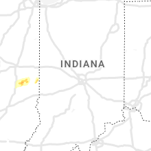
Indiana
| Local Time | Report Details |
|---|---|
| 1:45 AM EST | Report from mping: 1-inch tree limbs broken; shingles blown of in fountain county IN, 68.6 miles WNW of Indianapolis, IN |
| 2:15 AM EST | At county roads 500 north and 225 east. also hail about 0.5 inches in diameter lasted about 5 minute in carroll county IN, 61.4 miles NNW of Indianapolis, IN |
| 2:22 AM EST | Storm damage reported in cass county IN, 69.4 miles N of Indianapolis, IN |
| 2:29 AM EST | Mesonet station in004 2.6 nw argos (indot in marshall county IN, 61.6 miles W of Fort Wayne, IN |
| 2:35 AM EST | At kfkr frankfort municipal airpor in clinton county IN, 41 miles NNW of Indianapolis, IN |
| 3:10 AM EST | Call from fort wayne dispatch reporting power flashes and several reports of tree damage from around the count in allen county IN, 2.2 miles W of Fort Wayne, IN |
| 3:15 AM EST | Storm damage reported in huntington county IN, 24.1 miles SW of Fort Wayne, IN |
| 3:16 AM EST | Storm damage reported in allen county IN, 7.3 miles SW of Fort Wayne, IN |
| 3:19 AM EST | Power pole down on sr 5 just south of us 22 in huntington county IN, 24.4 miles SW of Fort Wayne, IN |
| 3:19 AM EST | Storm damage reported in allen county IN, 9.4 miles S of Fort Wayne, IN |
| 3:30 AM EST | Report from mping: 3-inch tree limbs broken; power poles broke in allen county IN, 7.1 miles NE of Fort Wayne, IN |
| 3:35 AM EST | Report from mping: trees uprooted or snappe in allen county IN, 3.1 miles ENE of Fort Wayne, IN |
| 3:37 AM EST | Poles down at intersection of county roads 650 east and 500 nort in delaware county IN, 56.5 miles NE of Indianapolis, IN |
| 4:22 AM EST | Several trees downed along reed road north of versailles. time estimated by rada in ripley county IN, 40.1 miles W of Cincinnati, OH |
Ohio
| Local Time | Report Details |
|---|---|
| 4:21 AM EST | Several trees downed along burns road. time estimated by rada in darke county OH, 65.8 miles N of Cincinnati, OH |
| 4:21 AM EST | Several trees downed along burns road. time estimated by rada in darke county OH, 65.1 miles SSE of Fort Wayne, IN |
| 4:22 AM EST | Several trees downed along reed road north of versailles. time estimated by rada in darke county OH, 65.6 miles SSE of Fort Wayne, IN |
Connect with Interactive Hail Maps