

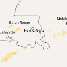
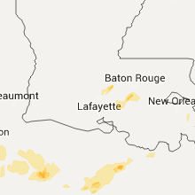
Hail Map for Thursday, May 19, 2016

Number of Impacted Households on 5/19/2016
0
Impacted by 1" or Larger Hail
0
Impacted by 1.75" or Larger Hail
0
Impacted by 2.5" or Larger Hail
Square Miles of Populated Area Impacted on 5/19/2016
0
Impacted by 1" or Larger Hail
0
Impacted by 1.75" or Larger Hail
0
Impacted by 2.5" or Larger Hail


Cities Most Affected by Hail Storms of 5/19/2016
| Hail Size | Demographics of Zip Codes Affected | ||||||
|---|---|---|---|---|---|---|---|
| City | Count | Average | Largest | Pop Density | House Value | Income | Age |
Hail and Wind Damage Spotted on 5/19/2016
Filter by Report Type:Hail ReportsWind Reports
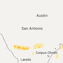
Texas
| Local Time | Report Details |
|---|---|
| 7:06 AM CDT | Ping Pong Ball sized hail reported near Carrizo Springs, TX, 68.9 miles NNW of Laredo, TX |
| 10:50 AM CDT | 7 to 10 trees down in bee county TX, 47.3 miles NNW of Corpus Christi, TX |
| 1:00 PM CDT | Trees down and power lines damaged at cr 347 and cr 654 in brazoria county TX, 50 miles SSW of Houston, TX |
| 1:00 PM CDT | Trees down and power lines damaged on cr 376 and fm 130 in brazoria county TX, 46 miles SSW of Houston, TX |
| 2:00 PM CDT | Trees down and power lines damaged at cr 347 and cr 654 in brazoria county TX, 50 miles SSW of Houston, TX |
| 2:00 PM CDT | Trees down and power lines damaged on cr 376 and fm 130 in brazoria county TX, 46 miles SSW of Houston, TX |
| 2:56 PM CDT | Tree down near northside elementary school in anglleto in brazoria county TX, 40.8 miles S of Houston, TX |
| 4:28 PM CDT | Quarter sized hail reported near Mcallen, TX, 53.9 miles WNW of Brownsville, TX, public reported quarter size hail near 29th street and nolana. |
Georgia
| Local Time | Report Details |
|---|---|
| 3:34 PM EDT | One tree down...taking a powerline down with i in brooks county GA, 49.2 miles ENE of Tallahassee, FL |
| 4:10 PM EDT | Three trees down on highway 80 about 1 mile northeast of knoxville in crawford county GA, 73.9 miles SSE of Atlanta, GA |
| 4:40 PM EDT | 1 tree down on emory drive in bibb county GA, 77.2 miles SSE of Atlanta, GA |
| 5:00 PM EDT | The call center reported a tree blocking manor millwood road. the time given was based on rada in ware county GA, 22.7 miles SSE of Douglas, GA |
| 5:48 PM EDT | Tree down across wiregrass road near evergreen roa in mitchell county GA, 51.7 miles N of Tallahassee, FL |
Florida
| Local Time | Report Details |
|---|---|
| 3:35 PM EDT | Wjxt relayed a damage photo via social media of a tin roof ripped off an outbuilding by strong wind gusts near boulogne. time of damage based on radar dat in nassau county FL, 35.1 miles NW of Jacksonville, FL |
| 4:35 PM EDT | Tree down and powerlines down near belfort and touchton roads. time estimated from rada in duval county FL, 6.6 miles SE of Jacksonville, FL |
| 7:50 PM EDT | 911 call center reported multiple trees down near county road 214 and county road 13 sout in st. johns county FL, 34.4 miles S of Jacksonville, FL |
| 7:52 PM EDT | 911 call center reported a few trees down in flagler estates in southern st johns count in st. johns county FL, 46.2 miles SSE of Jacksonville, FL |
| 5:15 AM CDT | Downed power lines reported on highway 231 near transmitter road. reported on social media in bay county FL, 46.3 miles ESE of Miramar Beach, FL |
| 5:15 AM CDT | Tree down blocking road in bay county FL, 45.9 miles ESE of Miramar Beach, FL |
| 5:25 AM CDT | Powerline down on roof in jackson county FL, 60.9 miles ENE of Miramar Beach, FL |
| 5:50 AM CDT | Tree down in jackson county FL, 61.8 miles WNW of Tallahassee, FL |
| 7:33 AM EDT | Tree down in the oak grove area in gadsden county FL, 31.9 miles WNW of Tallahassee, FL |
Utah
| Local Time | Report Details |
|---|---|
| 4:50 PM MDT | North salt flats mesonet sit in tooele county UT, 99.3 miles W of Salt Lake City, UT |
| 5:00 PM MDT | Lakeside mountain mesonet site in box elder county UT, 56.4 miles WNW of Salt Lake City, UT |
| 5:15 PM MDT | Hat island mesonet site in box elder county UT, 42.5 miles WNW of Salt Lake City, UT |
| 6:00 PM MDT | Ogden peak in weber county UT, 30.4 miles N of Salt Lake City, UT |
| 6:20 PM MDT | Playa station mesonet in tooele county UT, 72.8 miles WSW of Salt Lake City, UT |
| 6:25 PM MDT | Camelback mountain mesonet in tooele county UT, 71.3 miles SW of Salt Lake City, UT |
| 6:50 PM MDT | English village mesonet site in tooele county UT, 57.5 miles SW of Salt Lake City, UT |
| 7:42 PM MDT | Vernon raws in tooele county UT, 53.7 miles SSW of Salt Lake City, UT |
Louisiana
| Local Time | Report Details |
|---|---|
| 7:47 PM CDT | Quarter sized hail reported near Plaquemine, LA, 46.7 miles E of Lafayette, LA, quarter sized hail reported via social media. |
| 8:19 PM CDT | Public reports 65 mph wind gust measured with personal weather station...id c2220. trees were snapped from the gus in vermilion county LA, 22.4 miles SW of Lafayette, LA |
| 8:24 PM CDT | Cwop station in abbeville measured a wind gust of 70 mp in vermilion county LA, 26.4 miles SSW of Lafayette, LA |
| 8:45 PM CDT | Katc reports 60 mph wind gus in lafayette county LA, 0.8 miles W of Lafayette, LA |
| 8:45 PM CDT | Katc reports 60 mph wind gus in lafayette county LA, 0.8 miles W of Lafayette, LA |
| 8:50 PM CDT | Traffic signal on pole snappe in lafayette county LA, 6.3 miles NNW of Lafayette, LA |
| 9:18 PM CDT | Measured 51 knot wind gust at eugene island... la nos statio in st. mary county LA, 70 miles SSE of Lafayette, LA |
| 9:45 PM CDT | Broken windows... roof and porch damage along hwy 401/canal rd near lake veret. time estimated from rada in assumption county LA, 57.8 miles W of New Orleans, LA |
| 10:02 PM CDT | Tree down through roof of house in trailer park. 10 trees down across lafourche paris in lafourche county LA, 47.7 miles WSW of New Orleans, LA |
| 10:03 PM CDT | Trees reported down in convent and vacherie in st. james parish. time estimated from rada in st. james county LA, 45.3 miles W of New Orleans, LA |
| 10:05 PM CDT | Damage throughout terrebonne. power lines down in montegut. trees down in houma. power lines down and carport damaged in chauvin. time estimated from rada in terrebonne county LA, 45.9 miles SW of New Orleans, LA |
| 10:05 PM CDT | Tree down on home off s. peck drive in south baton rouge. relayed via social medi in east baton rouge county LA, 59.9 miles E of Lafayette, LA |
| 10:17 PM CDT | Trees down along hwy 61 near sorrent in ascension county LA, 50.2 miles WNW of New Orleans, LA |
| 10:20 PM CDT | Trees and power lines down along hwy 308 near valentine. time estimated from rada in lafourche county LA, 34.7 miles SW of New Orleans, LA |
| 10:20 PM CDT | Trees down along 4h club rd in denham springs. reported via social medi in livingston county LA, 64 miles NW of New Orleans, LA |
| 10:25 PM CDT | Power lines down near east st. john high school. relayed via social medi in st. john the bapti county LA, 27.7 miles WNW of New Orleans, LA |
| 10:30 PM CDT | Large tree down and personal weather station measured 68 mph wind gust in shenandoah area of baton roug in east baton rouge county LA, 57.5 miles ENE of Lafayette, LA |
| 11:00 PM CDT | Large limbs down...wood fences blown down and minor roof damage. location is in montgomery terrace subdivision off of highway 2 in tangipahoa county LA, 33.6 miles NNW of New Orleans, LA |
South Dakota
| Local Time | Report Details |
|---|---|
| 7:53 PM MDT | Quarter sized hail reported near Sturgis, SD, 23.5 miles N of Rapid City, SD, mainly pea to penny size hail. lasted about 30 minutes with hail accumulations of an inch or two alongside of house |
Mississippi
| Local Time | Report Details |
|---|---|
| 12:23 AM CDT | 40 foot tree snapped and leaned against another tree behind house in d iberville behind city hall. relayed via social medi in harrison county MS, 54.5 miles WSW of Mobile, AL |
Alabama
| Local Time | Report Details |
|---|---|
| 1:30 AM CDT | National ocean service - ports observatio in baldwin county AL, 31.5 miles S of Mobile, AL |
| 1:35 AM CDT | Middle bay lighthous in gmz631 county AL, 17.1 miles S of Mobile, AL |
| 2:12 AM CDT | Storm damage reported in gmz650 county AL, 51.7 miles SE of Mobile, AL |
Connect with Interactive Hail Maps