

Hail Map for Saturday, October 14, 2017

Number of Impacted Households on 10/14/2017
0
Impacted by 1" or Larger Hail
0
Impacted by 1.75" or Larger Hail
0
Impacted by 2.5" or Larger Hail
Square Miles of Populated Area Impacted on 10/14/2017
0
Impacted by 1" or Larger Hail
0
Impacted by 1.75" or Larger Hail
0
Impacted by 2.5" or Larger Hail


Cities Most Affected by Hail Storms of 10/14/2017
| Hail Size | Demographics of Zip Codes Affected | ||||||
|---|---|---|---|---|---|---|---|
| City | Count | Average | Largest | Pop Density | House Value | Income | Age |
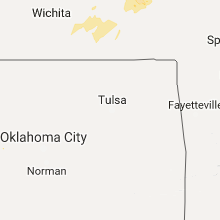
| Garnett, KS | 1 | 1.75 | 1.75 | 23 | $62k | $34.1k | 41.2 |
Hail and Wind Damage Spotted on 10/14/2017
Filter by Report Type:Hail ReportsWind Reports
Nebraska
| Local Time | Report Details |
|---|---|
| 7:48 AM CDT | Ping Pong Ball sized hail reported near Pawnee City, NE, 68.8 miles NNE of Manhattan, KS, mostly pea-sized to one inch... however larger stones as big as ping pongs. |
Kansas
| Local Time | Report Details |
|---|---|
| 10:05 AM CDT | *** 1 inj *** delayed report from dispatch of a fed ex truck being blown into the median on united states highway 54. driver was transported to the hospital. additional in kingman county KS, 60.1 miles W of Wichita, KS |
| 3:55 PM CDT | 3 inch branches down in butler county KS, 37.1 miles NE of Wichita, KS |
| 4:10 PM CDT | Estimated 60mph wind gust verified in chase county KS, 53.5 miles NE of Wichita, KS |
| 4:20 PM CDT | Delayed report. multiple reports of power lines down... trees down. generally north of 9th st. and east of iowa stree in douglas county KS, 37.6 miles WSW of Kansas City, MO |
| 4:39 PM CDT | Damage to a large tree... several branches down in butler county KS, 27 miles ENE of Wichita, KS |
| 4:43 PM CDT | Storm damage reported in leavenworth county KS, 21.9 miles W of Kansas City, MO |
| 4:46 PM CDT | Powerpoles dow in leavenworth county KS, 28.2 miles WSW of Kansas City, MO |
| 4:46 PM CDT | Semi truck jack knifed at mile marker 116 and us highway 75. no injuries were reported. time estimated by rada in osage county KS, 57.1 miles NNW of Chanute, KS |
| 4:49 PM CDT | Small outbuildings blown down. shingles blown off of roof. location near 16th and fauna road... just west of john redmond reservoi in coffey county KS, 45.9 miles NNW of Chanute, KS |
| 4:55 PM CDT | Relayed by the e in coffey county KS, 41.8 miles NNW of Chanute, KS |
| 5:09 PM CDT | Delayed report. mesonet station kukl... 2 nne new straw in coffey county KS, 45.1 miles NNW of Chanute, KS |
| 5:12 PM CDT | Large tree down over valley street in southeast wameg in pottawatomie county KS, 14.1 miles E of Manhattan, KS |
| 5:19 PM CDT | Social media report of 6 inch tree limb down. dispatch relayed multiple tree limbs and power lines down in the town. radar estimated tim in franklin county KS, 50.3 miles SW of Kansas City, MO |
| 5:26 PM CDT | Large tree down at 166th and evans rd. 20 inches in diamete in leavenworth county KS, 20.3 miles W of Kansas City, MO |
| 5:37 PM CDT | 60-70 estimated wind speed in greenwood county KS, 52.6 miles ENE of Wichita, KS |
| 5:55 PM CDT | Power pole snapped in cowley county KS, 31.7 miles SSE of Wichita, KS |
| 6:01 PM CDT | Large tree snapped in cowley county KS, 35.1 miles SE of Wichita, KS |
| 6:05 PM CDT | 12 inch+ diameter tree down near base. several limbs of 4-6 in diamater broke in allen county KS, 17.3 miles N of Chanute, KS |
| 6:05 PM CDT | Wind gust of approximately 70mph. 8 inch diameter treelimb broke in cowley county KS, 34.6 miles SE of Wichita, KS |
| 6:08 PM CDT | Farm outbuilding blown apar in coffey county KS, 37.8 miles NW of Chanute, KS |
| 6:08 PM CDT | Estimated 60-70 mph winds in greenwood county KS, 44.5 miles W of Chanute, KS |
| 6:10 PM CDT | 4 power poles snapped 2 miles south of winfield city lake in cowley county KS, 34.6 miles SE of Wichita, KS |
| 6:13 PM CDT | 1 mile of utility poles down on p rd with multiple trees blown down blocking roadways nnw of the eureka lake area in greenwood county KS, 48.8 miles WNW of Chanute, KS |
| 6:33 PM CDT | Quarter sized hail reported near Garnett, KS, 42.8 miles NNE of Chanute, KS, west side of garnett. |
| 6:33 PM CDT | Quarter sized hail reported near Garnett, KS, 41.7 miles N of Chanute, KS, correction to previous hail report from garnett. |
| 6:35 PM CDT | 70-80 mph estimated in woodson county KS, 26.4 miles WNW of Chanute, KS |
| 6:38 PM CDT | Golf Ball sized hail reported near Garnett, KS, 42.8 miles NNE of Chanute, KS, 1 mile west of garnett. |
| 6:41 PM CDT | Storm damage reported in woodson county KS, 20.4 miles NW of Chanute, KS |
| 6:59 PM CDT | Snapped power poles reported in allen county KS, 17.3 miles N of Chanute, KS |
| 7:02 PM CDT | Relayed report of power lines down. radar estimated tim in anderson county KS, 27.1 miles N of Chanute, KS |
| 7:08 PM CDT | Relayed report of utility poles dow in anderson county KS, 29.8 miles NNE of Chanute, KS |
| 7:18 PM CDT | 72mph wind gust reported at central schools in cowley county KS, 41.4 miles SE of Wichita, KS |
| 7:26 PM CDT | Multiple trees down at 300 rd and k-7 highway. time estimated to rada in linn county KS, 44.1 miles NE of Chanute, KS |
| 7:28 PM CDT | Shingles blown off roof. also reported multiple power outages across linn count in linn county KS, 47.2 miles NE of Chanute, KS |
Missouri
| Local Time | Report Details |
|---|---|
| 4:36 PM CDT | Power lines down and roof blown off home in millar in adair county MO, 48.9 miles WSW of Kahoka, MO |
| 4:55 PM CDT | Large tree branch blown down onto highway 15 about a mile north of edin in knox county MO, 29 miles SW of Kahoka, MO |
| 5:11 PM CDT | A farmstead was damaged and power lines down just east of gorin. possible tornado. first call came in at 512 p in scotland county MO, 15.9 miles WSW of Kahoka, MO |
| 5:11 PM CDT | Delayed report...12 inch branch down at worlds of fun. reported via social media. time estimated to rada in clay county MO, 6.8 miles NE of Kansas City, MO |
| 5:11 PM CDT | The sign of a fairfield inn across from worlds of fun was blown over. photos came to our office via twitte in clay county MO, 6.4 miles NE of Kansas City, MO |
| 5:15 PM CDT | Storm damage reported in clay county MO, 13.4 miles NE of Kansas City, MO |
| 5:15 PM CDT | Delayed report...reported at i-29 and 69 highwa in clay county MO, 6 miles N of Kansas City, MO |
| 5:19 PM CDT | Car crashed into a large tree branch that was down on the highwa in clark county MO, 6.2 miles SSW of Kahoka, MO |
| 5:29 PM CDT | Delayed report...multiple trees down on roadways. relocated a full 110 gallon water tank a significant distance from original location. report via social medi in jackson county MO, 21 miles E of Kansas City, MO |
| 5:31 PM CDT | Storm damage reported in clay county MO, 1.2 miles NNW of Kansas City, MO |
| 5:40 PM CDT | Storm damage reported in clay county MO, 8.9 miles NE of Kansas City, MO |
| 6:13 PM CDT | Storm damage reported in jackson county MO, 21.8 miles SE of Kansas City, MO |
| 6:18 PM CDT | Delayed report. roof damage to house in orrick. time estimated to rada in ray county MO, 26.1 miles ENE of Kansas City, MO |
| 6:20 PM CDT | Storm damage reported in cass county MO, 27.4 miles SE of Kansas City, MO |
| 6:21 PM CDT | Delayed report...trees down and debris in road south of harrisonville. report via social media. time estimated to rada in cass county MO, 34.3 miles SSE of Kansas City, MO |
| 8:50 PM CDT | Storm damage reported in pettis county MO, 62.4 miles WSW of Columbia, MO |
| 9:03 PM CDT | Storm damage reported in pettis county MO, 51.1 miles WSW of Columbia, MO |
Iowa
| Local Time | Report Details |
|---|---|
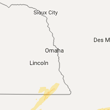
| 5:10 PM CDT | Quarter sized hail reported near West Burlington, IA, 39.5 miles NE of Kahoka, MO |
Illinois
| Local Time | Report Details |
|---|---|
| 5:48 PM CDT | Approximately a 20 foot by 80 foot section of roof torn off the fire statio in warren county IL, 57.1 miles WNW of Peoria, IL |
| 5:48 PM CDT | Quarter sized hail reported near Monmouth, IL, 57.2 miles WNW of Peoria, IL |
| 5:50 PM CDT | Half Dollar sized hail reported near Monmouth, IL, 57.5 miles WNW of Peoria, IL |
| 5:55 PM CDT | Trees down and roof damage to a fire house. time estimated from rada in warren county IL, 56.2 miles WNW of Peoria, IL |
| 6:09 PM CDT | Several large trees and tree branches blown down around town...time estimated by radar in knox county IL, 45.2 miles WNW of Peoria, IL |
| 6:25 PM CDT | Large tree snapped. possible tornad in hancock county IL, 37.2 miles ESE of Kahoka, MO |
| 6:35 PM CDT | Quarter sized hail reported near Augusta, IL, 43.3 miles ESE of Kahoka, MO |
| 6:58 PM CDT | Tree branches about 8 to 12 inches in diamater snapped in peoria county IL, 21 miles WNW of Peoria, IL |
| 7:03 PM CDT | Estimated 70 mph thunderstorm wind gust near route 97 and route 9 junction in fulton county IL, 32.3 miles WSW of Peoria, IL |
| 7:12 PM CDT | Estimated 12 inch diameter tree branch blown down on road...time estimated by radar in peoria county IL, 16.4 miles NNE of Peoria, IL |
| 7:20 PM CDT | Numerous trees blown down on highway 26...time estimated from radar...relayed by wmbd-tv tweet in woodford county IL, 14.8 miles NE of Peoria, IL |
| 7:20 PM CDT | Illinois route 26 closed near spring bay due to power line blown down...from idot in woodford county IL, 9.3 miles NNE of Peoria, IL |
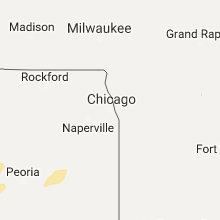
| 7:30 PM CDT | Trees down and powerpoles snapped in small less than 1000 foot long path along chicago road from near coy park road in vicinity of newark community high school northeas in kendall county IL, 54.5 miles WSW of Chicago, IL |
| 7:45 PM CDT | Utility line blown dow in la salle county IL, 49.9 miles NE of Peoria, IL |
| 8:40 PM CDT | Multiple large limbs and power lines downed. time estimated via rada in livingston county IL, 56.7 miles E of Peoria, IL |
| 11:35 PM CDT | Measured thunderstorm wind gust at jacksonville airport... awo in morgan county IL, 74.6 miles SSW of Peoria, IL |
Indiana
| Local Time | Report Details |
|---|---|
| 8:57 PM CDT | Power lines down at 77th and austin and at 77th and st john. large maple tree downed. time estimated off of rada in lake county IN, 28.8 miles SSE of Chicago, IL |
Oklahoma
| Local Time | Report Details |
|---|---|
| 9:19 PM CDT | 58 mph wind gust measured at the clinton-sherman airport aso in washita county OK, 76.2 miles S of Woodward, OK |
| 9:22 PM CDT | 68 mph wind gust measured at the clinton-sherman airport aso in washita county OK, 76.2 miles S of Woodward, OK |
| 10:40 PM CDT | Storm damage reported in canadian county OK, 29.9 miles WNW of Oklahoma City, OK |
| 10:48 PM CDT | Storm damage reported in canadian county OK, 29.9 miles WNW of Oklahoma City, OK |
| 10:55 PM CDT | Storm damage reported in canadian county OK, 25.1 miles W of Oklahoma City, OK |
| 11:03 PM CDT | Storm damage reported in oklahoma county OK, 7.8 miles WNW of Oklahoma City, OK |
| 11:10 PM CDT | Storm damage reported in grady county OK, 27.8 miles WSW of Oklahoma City, OK |
| 11:17 PM CDT | Storm damage reported in oklahoma county OK, 6.2 miles SW of Oklahoma City, OK |
| 11:28 PM CDT | Storm damage reported in oklahoma county OK, 7.7 miles ESE of Oklahoma City, OK |
| 11:53 PM CDT | Storm damage reported in pottawatomie county OK, 35.1 miles ESE of Oklahoma City, OK |
Michigan
| Local Time | Report Details |
|---|---|
| 6:45 AM EDT | Quarter sized hail reported near Ishpeming, MI, 14.3 miles W of Marquette, MI, delayed report. storm spotter reported quarter size hail for approximately 10 minutes. |
Connect with Interactive Hail Maps