

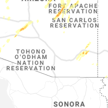
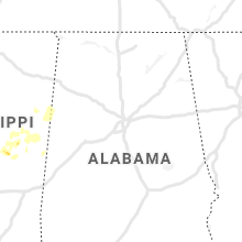
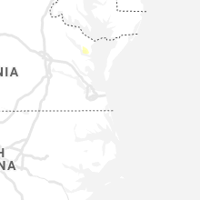
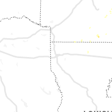
Hail Map for Tuesday, October 5, 2021

Number of Impacted Households on 10/5/2021
0
Impacted by 1" or Larger Hail
0
Impacted by 1.75" or Larger Hail
0
Impacted by 2.5" or Larger Hail
Square Miles of Populated Area Impacted on 10/5/2021
0
Impacted by 1" or Larger Hail
0
Impacted by 1.75" or Larger Hail
0
Impacted by 2.5" or Larger Hail


Cities Most Affected by Hail Storms of 10/5/2021
| Hail Size | Demographics of Zip Codes Affected | ||||||
|---|---|---|---|---|---|---|---|
| City | Count | Average | Largest | Pop Density | House Value | Income | Age |
Hail and Wind Damage Spotted on 10/5/2021
Filter by Report Type:Hail ReportsWind Reports
Arizona
| Local Time | Report Details |
|---|---|
| 10:12 AM MST | Cwop in yucca arizona measured 59 mph thunderstorm related wind gusts from 1012 to 101 in mohave county AZ, 30.6 miles NNE of Lake Havasu City, AZ |
| 10:30 AM MST | Reports of severe thunderstorm related wind damage just north of wikieup. multiple heavy duty command tents knocked down as well as every porta potty on sit in mohave county AZ, 50.5 miles ENE of Lake Havasu City, AZ |
| 10:48 AM MST | Kingman asos (kigm) reported thunderstorm wind gusts to 68 mph between 10:48 and 10:51 a in mohave county AZ, 58.9 miles NNE of Lake Havasu City, AZ |
| 10:48 AM MST | Winds in excess of 58 mph began at kingman airport at 1048 and continue to gust above severe thresholds. peak wind gust 68 mp in mohave county AZ, 59.1 miles NNE of Lake Havasu City, AZ |
| 10:50 AM MST | Trees and powerlines down across the city of kingman as reported by emergency manager. time estimated from rada in mohave county AZ, 52.1 miles NNE of Lake Havasu City, AZ |
| 12:50 PM MST | Tweeds point raws measured a gust to 58 mph at the 1333 hourly ob. time of gust estimated to be 1250 by rada in mohave county AZ, 37.4 miles SSW of Saint George, UT |
| 1:37 PM MST | ***delayed report***small tree limbs down. wind speed reported 50 mp in pinal county AZ, 36.1 miles E of Phoenix, AZ |
| 2:05 PM MST | ***slightly delayed report***mesonet station srp45 5.3 ne tortilla flat (srp in maricopa county AZ, 43.6 miles ENE of Phoenix, AZ |
| 2:28 PM MST | Mesonet station au919 2 sse roosevel in gila county AZ, 56.7 miles ENE of Phoenix, AZ |
| 5:30 PM MST | Quarter sized hail reported near Concho, AZ, 27.8 miles NE of Show Low, AZ, persistent large hail reported. |
| 6:02 PM MST | Quarter sized hail reported near Phoenix, AZ, 5.4 miles SSE of Phoenix, AZ, photo on social media of a 1 inch diameter hail stone. |
| 6:04 PM MST | Quarter sized hail reported near Phoenix, AZ, 3.7 miles SE of Phoenix, AZ, video on social media of a collection of hail with the largest stones estimated around 1 inch. |
Mississippi
| Local Time | Report Details |
|---|---|
| 1:47 PM CDT | Quarter sized hail reported near Jackson, MS, 2.6 miles WSW of Jackson, MS, hail up to the size of quarters fell along raymond road near the intersection with valley street. report with video relayed via twitter. |
| 4:45 PM CDT | Quarter sized hail reported near Hollandale, MS, 72.9 miles ENE of Bastrop, LA, hail up to around the size of quarters fell near darlove. |
| 6:10 PM CDT | Quarter sized hail reported near Noxapater, MS, 35.8 miles SSW of Starkville, MS, report relayed from the mayor of noxapater. |
| 6:40 PM CDT | Quarter sized hail reported near Louisville, MS, 25.4 miles SSW of Starkville, MS, public reports relayed by media. |
| 6:48 PM CDT | Tree down on a power lin in winston county MS, 33.5 miles SSW of Starkville, MS |
Maryland
| Local Time | Report Details |
|---|---|
| 4:57 PM EDT | Trees downed along buck harbor r in worcester county MD, 30.4 miles SW of Ocean City, MD |
Virginia
| Local Time | Report Details |
|---|---|
| 7:45 PM EDT | Power lines downed along mosquito beach l in lancaster county VA, 61.3 miles NNW of Virginia Beach, VA |
Connect with Interactive Hail Maps