

Hail Map for Friday, September 1, 2017

Number of Impacted Households on 9/1/2017
0
Impacted by 1" or Larger Hail
0
Impacted by 1.75" or Larger Hail
0
Impacted by 2.5" or Larger Hail
Square Miles of Populated Area Impacted on 9/1/2017
0
Impacted by 1" or Larger Hail
0
Impacted by 1.75" or Larger Hail
0
Impacted by 2.5" or Larger Hail

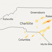


Cities Most Affected by Hail Storms of 9/1/2017
| Hail Size | Demographics of Zip Codes Affected | ||||||
|---|---|---|---|---|---|---|---|
| City | Count | Average | Largest | Pop Density | House Value | Income | Age |
| Fuquay Varina, NC | 4 | 2.50 | 2.75 | 427 | $137k | $50.2k | 36.6 |
| Davidson, NC | 1 | 1.75 | 1.75 | 573 | $244k | $70.2k | 37.0 |
| Finley, ND | 1 | 1.75 | 1.75 | 2 | $41k | $36.3k | 45.5 |
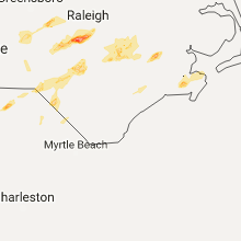
Hail and Wind Damage Spotted on 9/1/2017
Filter by Report Type:Hail ReportsWind Reports
Florida
| Local Time | Report Details |
|---|---|
| 11:15 AM EDT | Trees and power lines were blown down along miner road near hickory village. some homes had roof damage. the time of the event was based on radar imager in nassau county FL, 20.3 miles N of Jacksonville, FL |
| 2:10 PM EDT | Broadcast media relayed photographs showing several trees down near the uf health center. time estimated from radar dat in duval county FL, 10.4 miles N of Jacksonville, FL |
| 2:16 PM EDT | 911 call center reported power lines down on woodland drive. time estimated using radar dat in duval county FL, 10.4 miles N of Jacksonville, FL |
| 2:16 PM EDT | 911 call center reported power lines down near castleberry road and hollings street. time estimated from radar dat in duval county FL, 11.8 miles N of Jacksonville, FL |
| 2:20 PM EDT | 911 call center reported power lines down on dunn creek road. time estimated from radar dat in duval county FL, 11 miles NNE of Jacksonville, FL |
| 2:20 PM EDT | Off duty nws employee estimated wind gusts of 60 mp in duval county FL, 11.8 miles N of Jacksonville, FL |
| 3:00 PM EDT | 911 call center reported power lines down at the intersection of ne 9th street and ne 8th ave. time estimated from radar dat in marion county FL, 64.5 miles NW of Orlando, FL |
| 3:05 PM EDT | 911 call center reported power lines down at the intersection of se 14th street and se 25th ave. time estimated from radar dat in marion county FL, 61.7 miles NW of Orlando, FL |
| 4:12 PM EDT | Broadcast media relayed public report of tree damage on driftwood lan in putnam county FL, 59.8 miles NNW of Orlando, FL |
| 7:45 PM EDT | 911 call of a tree down on power lines near southeast 42 court and county road 326. time estimated by rada in levy county FL, 94.3 miles WNW of Orlando, FL |
| 8:09 PM EDT | Peak wind gust of 52 knots measured at wxflow sit in charlotte county FL, 48 miles SE of Bradenton, FL |
| 11:15 PM EDT | Trees and power lines were blown down along miner road near hickory village. some homes had roof damage. the time of the event was based on radar imager in nassau county FL, 20.3 miles N of Jacksonville, FL |
| 11:15 PM EDT | Trees and power lines were blown down near the intersection of harts road and airplane lane. some structural damage also occurred to roofs. the time of damage was based in nassau county FL, 18.8 miles N of Jacksonville, FL |
South Carolina
| Local Time | Report Details |
|---|---|
| 2:27 PM EDT | A few trees down with one falling on a powerline with transformer failure. this occurred near land in chester county SC, 31.9 miles SSW of Charlotte, NC |
| 2:45 PM EDT | Quarter sized hail reported near Ridgeway, SC, 58.8 miles S of Charlotte, NC, quarter-size hail near intersection of river rd and doe run lane. |
| 2:50 PM EDT | Quarter sized hail reported near Camden, SC, 54.7 miles S of Charlotte, NC, lake wateree campground reported quarter size hail. |
| 2:50 PM EDT | Lake wateree campground reported trees dow in kershaw county SC, 54.7 miles S of Charlotte, NC |
| 3:10 PM EDT | Quarter sized hail reported near Ridgeway, SC, 58.8 miles S of Charlotte, NC, quarter-size hail near intersection of river rd and doe run lane. |
| 3:40 PM EDT | Quarter sized hail reported near Mc Bee, SC, 61.4 miles SSE of Charlotte, NC, pea to quarter sized hail at quail ridge farms. |
| 3:40 PM EDT | Trees down highway 1 near mcbe in chesterfield county SC, 61.4 miles SSE of Charlotte, NC |
| 4:25 PM EDT | South carolina highway patrol reported a tree down on highway 321 near the intersection with honey hill roa in jasper county SC, 16.5 miles N of Savannah, GA |
| 4:25 PM EDT | Jasper county dispatch reported a tree down on highway 32 in jasper county SC, 17.2 miles N of Savannah, GA |
| 5:10 PM EDT | Colleton county dispatch reported a tree down on peirce road near cottageville highwa in colleton county SC, 32.4 miles WSW of Charleston, SC |
| 5:13 PM EDT | South carolina highway patrol reported 2 trees down in the 3500 block of rhode driv in colleton county SC, 31.3 miles SW of Charleston, SC |
| 5:24 PM EDT | South carolina highway patrol reported a tree down on highway 61 near the intersection with old beech hill roa in dorchester county SC, 22.8 miles SW of Charleston, SC |
| 5:38 PM EDT | South carolina highway patrol reported a tree down on dawson branch road near the intersection with highway 7 in dorchester county SC, 16.3 miles WSW of Charleston, SC |
| 3:56 AM EDT | Storm damage reported in amz330 county SC, 31.9 miles SSE of Charleston, SC |
| 3:56 AM EDT | Storm damage reported in amz330 county SC, 31.9 miles SSE of Charleston, SC |
| 3:59 AM EDT | Storm damage reported in amz350 county SC, 37.9 miles S of Charleston, SC |
| 3:59 AM EDT | Storm damage reported in amz350 county SC, 37.9 miles S of Charleston, SC |
| 4:05 AM EDT | Storm damage reported in amz350 county SC, 31.5 miles SSE of Charleston, SC |
| 4:05 AM EDT | Storm damage reported in amz350 county SC, 31.5 miles SSE of Charleston, SC |
| 4:06 AM EDT | Storm damage reported in amz330 county SC, 31.9 miles SSE of Charleston, SC |
| 4:07 AM EDT | The weatherflow sensor at fort sumter reported sustained winds 45 kt with gusts to 61 k in amz330 county SC, 31.9 miles SSE of Charleston, SC |
| 4:30 AM EDT | Trees down along seewee road near highway 17. time estimated based on rada in charleston county SC, 25.9 miles SE of Charleston, SC |
| 4:30 AM EDT | Tree down on guerins bridge road near woodville road. time estimated based on rada in charleston county SC, 24.1 miles SE of Charleston, SC |
North Carolina
| Local Time | Report Details |
|---|---|
| 2:35 PM EDT | Tree down in ellerbe. time estimated by rada in richmond county NC, 61.9 miles E of Charlotte, NC |
| 2:50 PM EDT | Fire dept/rescue reported power lines down on woodlark ln and andover r in mecklenburg county NC, 3.6 miles SE of Charlotte, NC |
| 2:50 PM EDT | Fire dept/rescue reported power lines down on audubon r in mecklenburg county NC, 3.3 miles SSE of Charlotte, NC |
| 2:50 PM EDT | Quarter sized hail reported near Mount Olive, NC, 43.9 miles SSE of Raleigh, NC, 1 inch hail reported on dobbersville road. |
| 2:53 PM EDT | Fire dept/rescue reported power lines down on water oak rd. time estimated from rada in mecklenburg county NC, 4 miles SE of Charlotte, NC |
| 3:00 PM EDT | Broadcast media reported power lines down on beaver correll and upright streets in landis in rowan county NC, 25.7 miles NNE of Charlotte, NC |
| 3:10 PM EDT | Tree down on carthage roa in moore county NC, 63.6 miles SW of Raleigh, NC |
| 3:10 PM EDT | Large live oak tree fell on a mobile home at 512 crows foot road and grantham school roa in wayne county NC, 45.8 miles SE of Raleigh, NC |
| 3:15 PM EDT | Tree down on route 73. time estimated by rada in moore county NC, 60.8 miles SW of Raleigh, NC |
| 3:45 PM EDT | Tree down on foushee rd and utility lines on tree on brooklyn av in randolph county NC, 56.7 miles W of Raleigh, NC |
| 3:52 PM EDT | Numerous trees dow in lee county NC, 42.4 miles SW of Raleigh, NC |
| 3:52 PM EDT | Several trees dow in lee county NC, 38.1 miles SW of Raleigh, NC |
| 4:00 PM EDT | Trees down with one tree down on a car and another tree down on a hous in lee county NC, 37.8 miles SW of Raleigh, NC |
| 4:10 PM EDT | Numerous trees blown down on north end of the cit in lee county NC, 36 miles SW of Raleigh, NC |
| 4:10 PM EDT | Two structures reported damage with roof collaps in lee county NC, 35.9 miles SW of Raleigh, NC |
| 4:20 PM EDT | Quarter sized hail reported near Sanford, NC, 37.3 miles SW of Raleigh, NC |
| 4:45 PM EDT | Numerous trees down across northern portions of the count in harnett county NC, 19.8 miles SSW of Raleigh, NC |
| 4:55 PM EDT | Golf Ball sized hail reported near Fuquay Varina, NC, 17.7 miles SW of Raleigh, NC, golfball hail reported at phelps west road. |
| 4:58 PM EDT | Baseball sized hail reported near Fuquay Varina, NC, 16.5 miles SSW of Raleigh, NC |
| 5:00 PM EDT | Tree down in road on glendon carthage roa in moore county NC, 48.6 miles WSW of Raleigh, NC |
| 5:00 PM EDT | Tree down in road on nc 24-2 in moore county NC, 52.6 miles SW of Raleigh, NC |
| 5:03 PM EDT | Tree down blocking raws church roa in harnett county NC, 20.1 miles SSW of Raleigh, NC |
| 5:03 PM EDT | Quarter sized hail reported near Raleigh, NC, 10.8 miles S of Raleigh, NC, quarter size hail reported on feldman drive. |
| 5:05 PM EDT | Baseball sized hail reported near Fuquay Varina, NC, 19 miles SSW of Raleigh, NC, baseball size hail reported at atkins road. large hail reported from 500 to 511pm. |
| 5:08 PM EDT | Tree blown down blocking roadwa in johnston county NC, 17.7 miles S of Raleigh, NC |
| 5:15 PM EDT | Baseball sized hail reported near Fuquay Varina, NC, 16.5 miles SSW of Raleigh, NC, in addition multiple trees have been blown down. |
| 5:24 PM EDT | 2 or 3 trees down near little farm roa in iredell county NC, 39.1 miles N of Charlotte, NC |
| 5:30 PM EDT | Quarter sized hail reported near Cary, NC, 15.6 miles W of Raleigh, NC |
| 5:33 PM EDT | One tree down on west side of troutma in iredell county NC, 33.2 miles N of Charlotte, NC |
| 6:21 PM EDT | Downed trees falling on power lines/equipmen in wake county NC, 4.1 miles NNW of Raleigh, NC |
| 6:30 PM EDT | A few trees dow in rutherford county NC, 55.6 miles NE of Greenville, SC |
| 6:50 PM EDT | Trees down on power line and equipmen in franklin county NC, 21.3 miles NE of Raleigh, NC |
| 7:11 PM EDT | Golf Ball sized hail reported near Davidson, NC, 16.4 miles N of Charlotte, NC, hail up to the size of golf balls fell at the river run golf course. |
| 7:11 PM EDT | One tree down near the center of the city. high wind at river run country club blew over a large potted plant and brought down small limb in mecklenburg county NC, 13.6 miles N of Charlotte, NC |
| 7:15 PM EDT | Lenoir co em reported damage to 3-4 buildings on snags path rd and turner farm l in lenoir county NC, 56.9 miles NNE of Wilmington, NC |
| 7:20 PM EDT | Trees down in the maury communit in greene county NC, 62.4 miles ESE of Raleigh, NC |
| 8:37 PM EDT | Several trees down in concord and a few powerlines. time derived from radar dat in cabarrus county NC, 19 miles NE of Charlotte, NC |
| 12:30 AM EDT | Minor damage to a deck... house struck by lightning in avo in mainland dare county NC, 101.8 miles SSE of Virginia Beach, VA |
Oklahoma
| Local Time | Report Details |
|---|---|
| 5:28 PM CDT | Quarter sized hail reported near Boise City, OK, 112.4 miles NNW of Amarillo, TX, some hail stones were just a tad larger than a quarter. |
North Dakota
| Local Time | Report Details |
|---|---|
| 5:59 PM CDT | Quarter sized hail reported near Mcville, ND, 35.4 miles ESE of Devils Lake, ND, heavy rain with a few dime to quarter sized hail. |
| 6:25 PM CDT | Half Dollar sized hail reported near Mcville, ND, 43.6 miles SE of Devils Lake, ND, a few hail up to half dollar sized just north of highway 15...in northwest lee township. |
| 6:56 PM CDT | Ping Pong Ball sized hail reported near Sharon, ND, 54 miles SE of Devils Lake, ND, ocassional nickel to ping pong ball sized hail in very heavy rain across southeast lenora township. |
| 7:25 PM CDT | Ping Pong Ball sized hail reported near Finley, ND, 60.5 miles SE of Devils Lake, ND, very heavy rain with ocassional large hail... a few up to golf ball sized. |
| 7:25 PM CDT | Golf Ball sized hail reported near Finley, ND, 60.5 miles SE of Devils Lake, ND, very heavy rain with ocassional large hail... a few up to golf ball sized. |
Kansas
| Local Time | Report Details |
|---|---|
| 10:10 PM CDT | Quarter sized hail reported near Garden City, KS, 9.5 miles ESE of Garden City, KS, hail of nickel up to quarter size was reported in the airport area. |
Connect with Interactive Hail Maps