

Hail Map Fort Scott, Kansas April 7, 2013
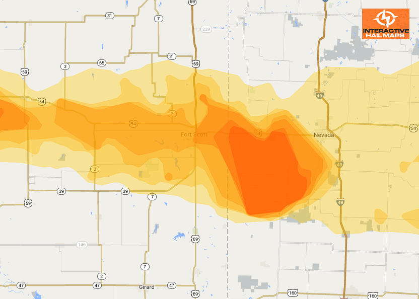
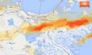
This map shows the hail that moved through Fort Scott, Kansas on April 7th, 2013.(Click on the map for a larger view) This hail storm moved over 100 miles from just outside Wichita to ultimately hit Fort Scott. Use Interactive Hail Maps to zoom all the way to street level and pinpoint the exact neighborhoods affected. Hail history back to January 2011 comes with your subscription. Check our prices. Find the hail storms others are missing.
Cities Most Affected by Hail Storms of 4/7/2013
| Hail Size | Demographics of Zip Codes Affected | ||||||
|---|---|---|---|---|---|---|---|
| City | Count | Average | Largest | Pop Density | House Value | Income | Age |
| Conway, MO | 2 | 1.75 | 1.75 | 29 | $61k | $30.4k | 40.1 |
| Bolivar, MO | 2 | 1.75 | 1.75 | 88 | $86k | $29.9k | 34.5 |
| La Crosse, KS | 1 | 2.00 | 2.00 | 8 | $41k | $31.5k | 47.7 |
| Mc Cracken, KS | 1 | 1.75 | 1.75 | 1 | $17k | $37.4k | 51.7 |
| Nevada, MO | 1 | 1.75 | 1.75 | 91 | $65k | $30.9k | 40.0 |
| Jerico Springs, MO | 1 | 1.75 | 1.75 | 10 | $42k | $32.9k | 48.5 |
| Fort Scott, KS | 1 | 1.75 | 1.75 | 42 | $48k | $31.0k | 37.2 |
| Uniontown, KS | 1 | 1.75 | 1.75 | 7 | $38k | $34.9k | 38.5 |
| Inman, KS | 1 | 1.75 | 1.75 | 12 | $84k | $41.3k | 45.4 |
| Phillipsburg, MO | 1 | 1.75 | 1.75 | 33 | $64k | $30.3k | 40.6 |
| Augusta, KS | 1 | 1.75 | 1.75 | 132 | $84k | $46.3k | 38.4 |
| Sheldon, MO | 1 | 1.75 | 1.75 | 12 | $35k | $30.7k | 37.8 |
| Severy, KS | 1 | 1.75 | 1.75 | 5 | $22k | $31.5k | 52.6 |
| Stockton, MO | 1 | 1.75 | 1.75 | 22 | $71k | $30.9k | 47.3 |
| Half Way, MO | 1 | 1.75 | 1.75 | 22 | $55k | $31.7k | 37.7 |
Connect with Interactive Hail Maps