

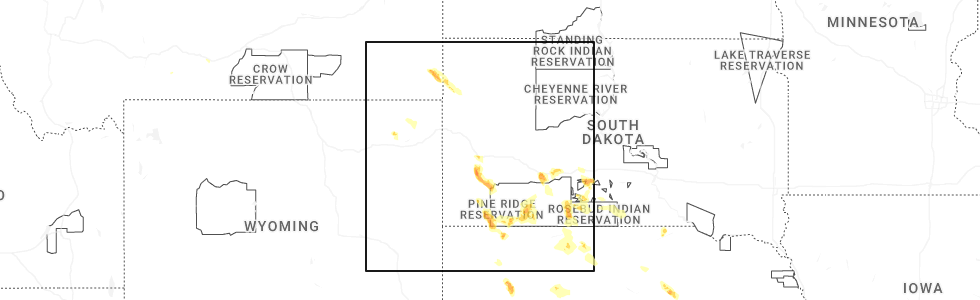
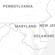
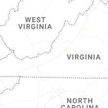
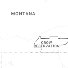
Hail Map for Tuesday, July 1, 2025
Number of Impacted Households on 7/1/2025
0
Impacted by 1" or Larger Hail
0
Impacted by 1.75" or Larger Hail
0
Impacted by 2.5" or Larger Hail
Square Miles of Populated Area Impacted on 7/1/2025
0
Impacted by 1" or Larger Hail
0
Impacted by 1.75" or Larger Hail
0
Impacted by 2.5" or Larger Hail

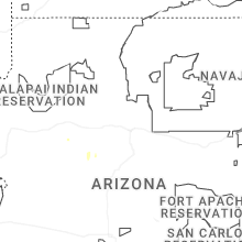
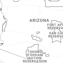


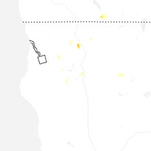
Cities Most Affected by Hail Storms of 7/1/2025
| Hail Size | Demographics of Zip Codes Affected | ||||||
|---|---|---|---|---|---|---|---|
| City | Count | Average | Largest | Pop Density | House Value | Income | Age |
| Alliance, NE | 1 | 2.00 | 2.00 | 10 | $73k | $39.4k | 40.8 |
| Lakeside, NE | 1 | 2.00 | 2.00 | 0 | $33k | $30.8k | 39.9 |
| White River, SD | 1 | 1.75 | 1.75 | 0 | $28k | $24.4k | 35.2 |
| Philip, SD | 1 | 1.75 | 1.75 | 0 | $52k | $31.7k | 49.7 |
Hail and Wind Damage Spotted on 7/1/2025
Filter by Report Type:Hail ReportsWind Reports
States Impacted
Ohio, West Virginia, Virginia, Kentucky, Maryland, Pennsylvania, New York, Nevada, Massachusetts, Idaho, New Jersey, Mississippi, Alabama, Wyoming, North Carolina, South Dakota, South Carolina, Connecticut, Montana, Colorado, NebraskaOhio
| Local Time | Report Details |
|---|---|
| 9:35 AM EDT | Line down on carbondale road. time estimated from rada in athens county OH, 56 miles SE of Columbus, OH |
| 9:41 AM EDT | Tree... powerlines and utility poles down on burr oak blvd. boulevard was closed. time estimated from rada in athens county OH, 54.6 miles SE of Columbus, OH |
| 10:36 AM EDT | Tree down on powerlines with fire. time estimated from rada in athens county OH, 65.2 miles N of Charleston, WV |
West Virginia
| Local Time | Report Details |
|---|---|
| 11:26 AM EDT | Powerlines down on brooklyn drive. time from pkb asos and rada in wood county WV, 64.4 miles N of Charleston, WV |
| 12:04 PM EDT | Tree and power lines down. tree smoking on line. time estimated from rada in ritchie county WV, 67.3 miles NNE of Charleston, WV |
| 12:54 PM EDT | Tree down. time estimated from rada in putnam county WV, 22.3 miles NW of Charleston, WV |
| 1:35 PM EDT | Three trees down on trout run road... one mile south of wardensvill in hardy county WV, 64 miles E of Elkins, WV |
| 2:11 PM EDT | Tree down blocking all of state route 34 south. no lines involved. time estimated from rada in putnam county WV, 19.8 miles W of Charleston, WV |
| 2:19 PM EDT | Tree down. time corroborated via rada in putnam county WV, 17.5 miles WNW of Charleston, WV |
| 3:34 PM EDT | Tree down blocking pond drive. time estimated from rada in logan county WV, 34.1 miles SW of Charleston, WV |
| 5:18 PM EDT | Large tree fell across the tracks in ritter hollow. no lines dow in mcdowell county WV, 61.5 miles NNE of Bristol, TN |
| 8:35 PM EDT | Tree down in the 6500 block of highland trail. time estimated from rada in greenbrier county WV, 46.7 miles NW of Roanoke, VA |
Virginia
| Local Time | Report Details |
|---|---|
| 1:47 PM EDT | Tree damage was reported southeast of alanthus... including a tree that blew down near the intersection of va-663 alanthus road and farley roa in culpeper county VA, 71.4 miles N of Richmond, VA |
| 1:51 PM EDT | Two trees down just east of ryleyville on rileyville rd in page county VA, 79.3 miles E of Elkins, WV |
| 2:26 PM EDT | There were a few calls for trees and wires blown down across the city of alexandri in city of alexandria county VA, 41.5 miles SW of Baltimore, MD |
| 2:39 PM EDT | Large tree limbs (greater than three inches in diameter) blew down in the west gate are in prince william county VA, 59 miles SW of Baltimore, MD |
| 2:42 PM EDT | Trees and large branches blew down on fauquier lane near va-673 lawyers roa in fairfax county VA, 47.3 miles WSW of Baltimore, MD |
| 2:44 PM EDT | Wind damage was reported near chantilly... including a power pole down near fair lakes parkwa in fairfax county VA, 51.9 miles SW of Baltimore, MD |
| 2:46 PM EDT | Tree down onto powerlines near intersection of rocks gap rd and runions creek rd in rockingham county VA, 55.9 miles ESE of Elkins, WV |
| 2:50 PM EDT | There were a couple of calls for trees and wires blown down in southern fairfax count in fairfax county VA, 54.4 miles SW of Baltimore, MD |
| 2:55 PM EDT | Tree damage was reported near fairfax... including a tree that blew down on va-699 prosperity avenue near morningside driv in fairfax county VA, 45.9 miles SW of Baltimore, MD |
| 3:12 PM EDT | Trees and large branches blew down on elmwood drive near south quaker lan in fairfax county VA, 42.6 miles SW of Baltimore, MD |
| 3:17 PM EDT | There were a few calls for large tree limbs blown down across southern arlingto in arlington county VA, 40.1 miles SW of Baltimore, MD |
| 4:29 PM EDT | There were several reports of wind damage around mount crawford... including wires down in the 6600 block of scholars roa in rockingham county VA, 65.1 miles SE of Elkins, WV |
| 4:30 PM EDT | Several large trees blew down around grottoe in rockingham county VA, 71.1 miles SE of Elkins, WV |
| 4:39 PM EDT | Tree down at dante mountain rd. and stratton bridge rd. in nora. time estimated from rada in dickenson county VA, 35.2 miles NNW of Bristol, TN |
| 4:43 PM EDT | Two trees reported down on skyline drive near brown mountai in greene county VA, 76.6 miles NW of Richmond, VA |
| 4:57 PM EDT | Two trees reported down in graves mill are in madison county VA, 74.4 miles NNW of Richmond, VA |
| 5:06 PM EDT | Three calls for trees down near wolftow in madison county VA, 70.3 miles NNW of Richmond, VA |
| 5:09 PM EDT | Tree down near intersection of rt 20 and spotswood trail in orange county VA, 57.4 miles NW of Richmond, VA |
| 5:13 PM EDT | Large tree down near intersection of rt 20 and jacksontown rd in orange county VA, 57.5 miles NNW of Richmond, VA |
| 5:15 PM EDT | Several trees blew down around a cooperative weather observer's residence in somerset (somv2 in orange county VA, 61.6 miles NNW of Richmond, VA |
| 5:20 PM EDT | Tree down near intersection of rt 15 and petersburg rd in orange county VA, 59.1 miles NNW of Richmond, VA |
| 5:50 PM EDT | Storm damaged caused a power outage near gordonsvill in louisa county VA, 51.4 miles NW of Richmond, VA |
| 6:01 PM EDT | Several trees down around the raven and richlands areas. time estimated from rada in tazewell county VA, 40.6 miles NNE of Bristol, TN |
| 6:15 PM EDT | Corrects previous tstm wnd dmg report from 3 s appomattox. tree down on red house roa in appomattox county VA, 61.3 miles E of Roanoke, VA |
| 6:20 PM EDT | The ashland... hanover county municipal airport asos (ofp) gusted to 60 mp in hanover county VA, 18.7 miles NE of Richmond, VA |
| 6:21 PM EDT | The public reported several trees down across the city of richmond. time estimated from rada in henrico county VA, 15 miles NE of Richmond, VA |
| 6:23 PM EDT | A tree fell down along greenwood r in henrico county VA, 15.6 miles NNE of Richmond, VA |
| 6:25 PM EDT | Tree down in the state forest across woolridge road near state park roa in appomattox county VA, 56.3 miles W of Richmond, VA |
| 6:30 PM EDT | A tree fell down along cady mills r in hanover county VA, 22.4 miles NE of Richmond, VA |
| 6:33 PM EDT | A tree fell at the intersection of east patrick henry rd and woodside l in hanover county VA, 20.8 miles NNE of Richmond, VA |
| 6:36 PM EDT | A tree fell down at the intersection of pleasant mill rd and mabelton r in hanover county VA, 24.2 miles N of Richmond, VA |
| 6:43 PM EDT | A power line was blown down by thunderstorm winds near the intersection of cross stitch road and mount cross road. time estimated from rada in pittsylvania county VA, 47 miles SSE of Roanoke, VA |
| 6:48 PM EDT | A large tree fell onto a house on white oak drive. no injuries reporte in caroline county VA, 32.1 miles NE of Richmond, VA |
| 6:50 PM EDT | Tree down at the intersection of herring and west river r in king william county VA, 34.2 miles NE of Richmond, VA |
| 6:50 PM EDT | Tree knocked down at the intersection of hazelwood and w river r in king william county VA, 35.4 miles NE of Richmond, VA |
| 6:55 PM EDT | 2 trees down along rt-30 in caroline county VA, 36.4 miles NNE of Richmond, VA |
| 6:56 PM EDT | A tree fell down in bowling gree in caroline county VA, 41.4 miles NNE of Richmond, VA |
| 7:00 PM EDT | 2 trees down near sunshine rd along rt. 30 in caroline county VA, 31.7 miles NNE of Richmond, VA |
| 7:04 PM EDT | Trees and large branches blew down on va-629 round hill road blocking the roadway west of jean driv in king george county VA, 60.8 miles NNE of Richmond, VA |
| 7:08 PM EDT | A tree knocked down a powerline on buckner r in louisa county VA, 31.3 miles NNW of Richmond, VA |
| 7:26 PM EDT | A couple of trees knocked down in westmoreland state par in westmoreland county VA, 62.6 miles NE of Richmond, VA |
| 7:28 PM EDT | Tree downed and blocking us-17 in the vicinity of occupacia r in essex county VA, 51.4 miles NE of Richmond, VA |
| 7:40 PM EDT | The 911 call center reported a tree down on cartersville road. time estimated from rada in powhatan county VA, 21.3 miles WNW of Richmond, VA |
| 7:43 PM EDT | Numerous trees down in mt. holl in westmoreland county VA, 65.1 miles NE of Richmond, VA |
| 7:45 PM EDT | Tree dow in pittsylvania county VA, 47.5 miles SSE of Roanoke, VA |
| 7:47 PM EDT | Corrects previous tstm wnd dmg report from 2 wnw brosville. tree dow in pittsylvania county VA, 47.5 miles SSE of Roanoke, VA |
| 7:50 PM EDT | Numerous trees down in the proximity of hagu in westmoreland county VA, 67.3 miles NE of Richmond, VA |
| 7:54 PM EDT | Tree down partially blocking blairmont drive near finch drive. time estimated from rada in pittsylvania county VA, 51.8 miles SE of Roanoke, VA |
| 8:02 PM EDT | The 911 call center reported a tree down on maple grove. time estimated from rada in powhatan county VA, 12.6 miles WNW of Richmond, VA |
| 8:07 PM EDT | Tree down along broad street r in goochland county VA, 12.7 miles NNW of Richmond, VA |
| 8:25 PM EDT | Updated report. northbound va-605 closed at genito rd due to a downed tree. time is radar-estimate in chesterfield county VA, 6.1 miles SSE of Richmond, VA |
| 8:32 PM EDT | Powerlines knocked down by severe weather causing power outages across amelia count in amelia county VA, 21.3 miles WSW of Richmond, VA |
| 8:32 PM EDT | Tree down on rt. 609 in the county of amelia... in the vicinity of elm cottage rd; rt. 629e/w (amelia county)... all north lanes are closed. all south lanes are close in amelia county VA, 20.1 miles WSW of Richmond, VA |
| 8:41 PM EDT | The 911 call center reported several trees down across the county. time estimated from rada in henrico county VA, 12.9 miles NE of Richmond, VA |
| 8:41 PM EDT | The 911 call center reported several trees down across the county. some fallen trees resulted in power outages. time estimated from rada in henrico county VA, 10.7 miles NNE of Richmond, VA |
| 8:45 PM EDT | Storm damage caused power outage across pats of the town of farmvill in prince edward county VA, 43 miles WSW of Richmond, VA |
| 8:50 PM EDT | Powerlines damaged by severe weather causing power outages across powhatan count in powhatan county VA, 10.6 miles WSW of Richmond, VA |
| 9:05 PM EDT | ~ 8 thousand people with loss of power caused by thunderstorm damag in city of richmond county VA, 12.4 miles ENE of Richmond, VA |
| 9:24 PM EDT | Power outages caused by storm damag in prince edward county VA, 39 miles WSW of Richmond, VA |
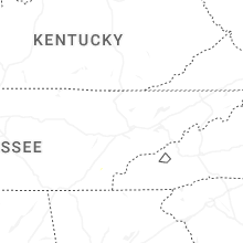
Kentucky
| Local Time | Report Details |
|---|---|
| 2:31 PM EDT | Power pole with guy wire broken. time estimated from rada in greenup county KY, 60.5 miles WNW of Charleston, WV |
| 4:18 PM EDT | Kenwood drive briefly flooded with debri in greenup county KY, 58.2 miles WNW of Charleston, WV |
Maryland
| Local Time | Report Details |
|---|---|
| 2:35 PM EDT | Tree damage was reported near brunswick... including a tree that blew down on md-478 knoxville road at western avenu in frederick county MD, 55.8 miles W of Baltimore, MD |
| 2:55 PM EDT | Tree damage was reported near roxbury mills... including a large tree that blew down onto flintridge drive near sundown roa in montgomery county MD, 25 miles W of Baltimore, MD |
| 2:59 PM EDT | Trees and large branches blew down on southbound i-495 capital beltway outer loop at exit 39/md-190 river roa in montgomery county MD, 36.1 miles SW of Baltimore, MD |
| 2:59 PM EDT | Two trees down on red pump rd north of rising sun in cecil county MD, 40.9 miles NE of Baltimore, MD |
| 3:00 PM EDT | Trees and large branches blew down on southbound i-270 at exit 6/md-28 west montgomery avenu in montgomery county MD, 33.1 miles WSW of Baltimore, MD |
| 3:08 PM EDT | Tree damage was reported in bethesda... including a tree that brought down wires and damaged a pole in the 9900 block of de paul driv in montgomery county MD, 33.6 miles WSW of Baltimore, MD |
| 3:12 PM EDT | Trees and large branches blew down on md-80 fingerboard road at chaucer court/tranquility cour in frederick county MD, 35 miles W of Baltimore, MD |
| 3:20 PM EDT | Tree fell onto a car near 13000th block of old frederick road in sykesvill in howard county MD, 18.9 miles W of Baltimore, MD |
| 3:20 PM EDT | Tree damage was reported in oxon hill... including a tree that blew down into the roadway blocking a driveway in the 900 block of east meadow cour in prince georges county MD, 38.7 miles SSW of Baltimore, MD |
| 3:30 PM EDT | Tree damage was reported in riverdale... including a tree that blew down onto power lines in the 6400 block of 46th avenu in prince georges county MD, 28.4 miles SW of Baltimore, MD |
| 4:25 PM EDT | Trees and large branches blew down on us-50 near exit 29/md-179 cape saint claire roa in anne arundel county MD, 19.9 miles SSE of Baltimore, MD |
| 4:25 PM EDT | There were a few calls for trees and wires down in eastern baltimore count in baltimore county MD, 9 miles ENE of Baltimore, MD |
| 4:34 PM EDT | Tree damage was reported in bel air... including a tree that blew down onto an unoccupied car in the 100 block of duncannon roa in harford county MD, 21.7 miles NE of Baltimore, MD |
| 4:40 PM EDT | Trees and large branches blew down on eastbound md-7 philadelphia road past md-152 mountain roa in harford county MD, 17.7 miles NE of Baltimore, MD |
| 4:51 PM EDT | Trees down around the rock hall area. time estimated from rada in kent county MD, 22.9 miles ESE of Baltimore, MD |
| 5:07 PM EDT | Trees down. time estimated from rada in queen anne's county MD, 37.5 miles ESE of Baltimore, MD |
| 5:21 PM EDT | Trees down around centreville. time estimated from rada in queen anne's county MD, 33.9 miles ESE of Baltimore, MD |
| 6:05 PM EDT | Tree damage was reported near huntingtown... including a tree that blew down in the 2400 block of kimberly lan in calvert county MD, 48.3 miles S of Baltimore, MD |
| 6:05 PM EDT | Tree damage was reported in huntingtown... including a tree that blew down onto power lines causing a fire in the 1600 block of stone driv in calvert county MD, 44.9 miles S of Baltimore, MD |
| 6:15 PM EDT | Tree damage was reported near mechanicsville... including a tree that blew down onto a house in the 40200 block of waterview driv in st. marys county MD, 55.4 miles S of Baltimore, MD |
| 7:46 PM EDT | Multiple trees uprooted and damaged along breton bay driv in st. marys county MD, 69 miles S of Baltimore, MD |
| 7:47 PM EDT | Tree damage reported on medleys neck road between point lookout road and breton driv in st. marys county MD, 69.7 miles S of Baltimore, MD |
| 7:49 PM EDT | Tree onto a residence on winding wa in st. marys county MD, 72.1 miles S of Baltimore, MD |
| 7:51 PM EDT | Trees downed along johnson road in hollywood... md as storms move throug in st. marys county MD, 64.9 miles S of Baltimore, MD |
| 7:51 PM EDT | A couple calls for trees down on willows road near point lookout roa in st. marys county MD, 73.6 miles S of Baltimore, MD |
Pennsylvania
| Local Time | Report Details |
|---|---|
| 2:35 PM EDT | Trees and wires down at the intersection of fremont road and lees bridge road. time estimated from rada in chester county PA, 43.4 miles NE of Baltimore, MD |
| 2:40 PM EDT | Trees and wires down on hopewell road. one tree fell on a vehicle. time estimated from rada in chester county PA, 48.6 miles NE of Baltimore, MD |
| 2:55 PM EDT | Trees down all along west christine road from the county line to hopewell road. time estimated from rada in chester county PA, 44.6 miles NE of Baltimore, MD |
| 3:05 PM EDT | Trees down on bustleton ave and winchester ave blocking much of the roadway. time estimated from rada in philadelphia county PA, 69.7 miles SW of Brooklyn, NY |
| 3:35 PM EDT | Trees and wires down on palmyra bellegrove road near the intersection of albert driv in lebanon county PA, 73.8 miles N of Baltimore, MD |
| 3:35 PM EDT | Tree down into wire in lebanon county PA, 75.3 miles N of Baltimore, MD |
| 3:50 PM EDT | Multiple trees down in jackson townshi in lebanon county PA, 77.2 miles SSW of Scranton, PA |
| 4:02 PM EDT | Tree down on wires on ted wallace road in chanceford townshi in york county PA, 39.3 miles N of Baltimore, MD |
| 4:03 PM EDT | Tree down on wire in york county PA, 45.3 miles N of Baltimore, MD |
| 4:06 PM EDT | Tree down across dark hollow road in hellam townshi in york county PA, 51.8 miles N of Baltimore, MD |
| 4:25 PM EDT | Picture shows trees down on reedy road in the whitfield area of sinking springs. time estimated from rada in berks county PA, 76.2 miles SSW of Scranton, PA |
| 4:27 PM EDT | Tree down with no wires on fox ridge lan in lebanon county PA, 72.7 miles N of Baltimore, MD |
| 4:28 PM EDT | 58 mph thunderstorm wind gust... and 45 mph sustained win in berks county PA, 72.8 miles SSW of Scranton, PA |
| 4:31 PM EDT | 63 mph thunderstorm wind gust... and 41 mph sustained win in berks county PA, 72.8 miles SSW of Scranton, PA |
| 4:33 PM EDT | Multiple trees down in bethel townshi in lebanon county PA, 77.4 miles N of Baltimore, MD |
| 4:38 PM EDT | Picture shows large tree down across main street in gibraltar. time estimated from rada in berks county PA, 78.7 miles S of Scranton, PA |
| 4:40 PM EDT | Some trees down on lake road in oley... some blocking the roadway. time estimated from rada in berks county PA, 70 miles S of Scranton, PA |
| 4:40 PM EDT | Tree uprooted. time estimated from rada in berks county PA, 76.2 miles SSW of Scranton, PA |
| 4:43 PM EDT | Thunderstorm damage reported near the intersection of sunset drive and pleasant valley roa in lancaster county PA, 68.7 miles NNE of Baltimore, MD |
| 4:46 PM EDT | Social media post shows several trees down in locust grove in amity. time estimated from rada in berks county PA, 75.3 miles S of Scranton, PA |
| 4:46 PM EDT | Some large trees blown over on weavertown road in douglassville. time estimated from rada in berks county PA, 76.1 miles S of Scranton, PA |
| 4:48 PM EDT | Tree into a house on conrad road with multiple people trappe in berks county PA, 67.2 miles S of Scranton, PA |
| 4:48 PM EDT | Multiple trees uprooted and snapped on weavertown road. tornado possible. time estimated from rada in berks county PA, 76.1 miles S of Scranton, PA |
| 4:56 PM EDT | Social media post showed a tree down blocking a roadway in boyertown. time estimated from rada in berks county PA, 74.5 miles S of Scranton, PA |
| 4:58 PM EDT | Multiple reports of trees and wires down. time estimated from rada in montgomery county PA, 76.7 miles S of Scranton, PA |
| 4:58 PM EDT | Tree on a car. time estimated from rada in berks county PA, 70.7 miles S of Scranton, PA |
| 5:00 PM EDT | Multiple reports of trees and wires down. time estimated from rada in montgomery county PA, 73.9 miles S of Scranton, PA |
| 5:14 PM EDT | Multiple trees snapped and uprooted. time estimated from rada in berks county PA, 64.9 miles S of Scranton, PA |
| 5:53 PM EDT | Multiple trees down. time estimated from rada in montgomery county PA, 75.7 miles WSW of Brooklyn, NY |
New York
| Local Time | Report Details |
|---|---|
| 3:10 PM EDT | Tree down southwest of johnstown along ny 33 in fulton county NY, 27.1 miles WNW of Schenectady, NY |
| 3:11 PM EDT | Tree downed on phillips avenu in montgomery county NY, 32.5 miles W of Schenectady, NY |
| 3:12 PM EDT | Tree downed and blocking stone arabia road in the town of mohaw in montgomery county NY, 28.5 miles WNW of Schenectady, NY |
| 3:38 PM EDT | Tree downed on a house on knollwood avenu in montgomery county NY, 16.2 miles NW of Schenectady, NY |
| 3:51 PM EDT | Tree down on wires near the intersection of pratt hill rd and acorn ln. time estimated from rada in columbia county NY, 39.7 miles SSE of Schenectady, NY |
| 4:00 PM EDT | Trees downed on route 50 near the corner of gleason roa in schenectady county NY, 5.5 miles N of Schenectady, NY |
| 4:15 PM EDT | Tree downed at intersection of state route 199 and wilcox park roa in dutchess county NY, 59.7 miles S of Schenectady, NY |
| 4:35 PM EDT | Tree downed with branches blocking albany post road at market stree in dutchess county NY, 70.6 miles S of Schenectady, NY |
| 4:52 PM EDT | Tree downed and across roadway at intersection of bethel cross road and strever farm roa in dutchess county NY, 61.4 miles SSE of Schenectady, NY |
Nevada
| Local Time | Report Details |
|---|---|
| 12:41 PM PDT | Station: rock spring creek... id: rscn2... elevation: 5427 fee in elko county NV, 63.3 miles S of Twin Falls, ID |
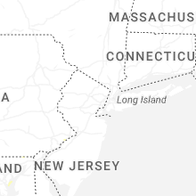
Massachusetts
| Local Time | Report Details |
|---|---|
| 4:10 PM EDT | Several reports of trees on wires in west stockbridge. time estimated from rada in berkshire county MA, 44.2 miles SE of Schenectady, NY |
| 4:20 PM EDT | Report of a tree down on wires in the vicinity of sherwood drive in lenox. time estimated from rada in berkshire county MA, 46.7 miles SE of Schenectady, NY |
| 6:00 PM EDT | In belchertown... multiple wires were down on pelham road near federal street. report relayed via amateur radi in hampshire county MA, 60.6 miles WNW of Providence, RI |
| 6:00 PM EDT | In belchertown there were multiple powerlines down in the area of george hannum street. report relayed via amateur radi in hampshire county MA, 60.6 miles WNW of Providence, RI |
| 6:00 PM EDT | In belchertown... there was a large branch down on power lines blocking town beach r in hampshire county MA, 61.7 miles WNW of Providence, RI |
| 7:15 PM EDT | In northbridge a tree was downed in the area of purgatory road. report relayed via amateur radi in worcester county MA, 25.8 miles NW of Providence, RI |
| 7:25 PM EDT | In mendon a tree was down blocking more than half of crestview drive. relayed via amateur radi in worcester county MA, 21.5 miles NNW of Providence, RI |
Idaho
| Local Time | Report Details |
|---|---|
| 2:21 PM MDT | Corrects previous tstm wnd gst report from 1 ssw michau in power county ID, 47.9 miles SW of Idaho Falls, ID |
| 3:45 PM MDT | Measured at the inl puzzle itd mesonet sit in butte county ID, 42.6 miles W of Idaho Falls, ID |
| 3:46 PM MDT | About 120 customers without power in the are west of springfiel in bingham county ID, 46 miles SW of Idaho Falls, ID |
| 3:49 PM MDT | Several hundred customers without power near and east of pingre in bingham county ID, 37.5 miles SW of Idaho Falls, ID |
| 4:17 PM MDT | Measured at the cotton ridge raws mesonet sit in cassia county ID, 31.4 miles SSE of Twin Falls, ID |
| 5:14 PM MDT | About 26 customers without power in the inkom are in bannock county ID, 48.9 miles SSW of Idaho Falls, ID |
| 5:59 PM MDT | Idaho power reports outages in the moreland and riverside areas due to thunderstorm outflow wind in bingham county ID, 27.5 miles SW of Idaho Falls, ID |
New Jersey
| Local Time | Report Details |
|---|---|
| 4:30 PM EDT | Multiple trees down. time estimated from rada in ocean county NJ, 44 miles SSW of Brooklyn, NY |
| 4:40 PM EDT | Multiple trees down. time estimated from rada in ocean county NJ, 40.9 miles SSW of Brooklyn, NY |
| 7:05 PM EDT | Njwxnet station at little egg harbor. sustained wind of 55 mph also reporte in ocean county NJ, 82.8 miles SSW of Brooklyn, NY |
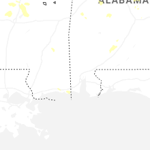
Mississippi
| Local Time | Report Details |
|---|---|
| 3:34 PM CDT | Kpib measured 60 mph wind gus in jones county MS, 75.5 miles SE of Jackson, MS |
| 3:49 PM CDT | Lines down and a large area out of power n of canto in madison county MS, 32.8 miles NNE of Jackson, MS |
| 4:00 PM CDT | Several trees down ne of canto in madison county MS, 30.4 miles NNE of Jackson, MS |
| 4:40 PM CDT | Large tree branch down near popps ferry roa in harrison county MS, 54.4 miles WSW of Mobile, AL |
| 4:40 PM CDT | Lines down and power ou in hinds county MS, 13.4 miles NNW of Jackson, MS |
| 4:56 PM CDT | Asos station kgpt gulfport-biloxi intl airpor in harrison county MS, 63.5 miles WSW of Mobile, AL |
| 4:59 PM CDT | Public reported power lines down on washington avenue near bayou vie in harrison county MS, 62.6 miles WSW of Mobile, AL |
| 4:59 PM CDT | Public reported a tree down on west pine stree in harrison county MS, 61.5 miles WSW of Mobile, AL |
| 4:59 PM CDT | Asos station kgpt gulfport-biloxi intl airpor in harrison county MS, 63.5 miles WSW of Mobile, AL |
| 5:09 PM CDT | A few trees down in town... oak st... confederate av in warren county MS, 40.4 miles W of Jackson, MS |
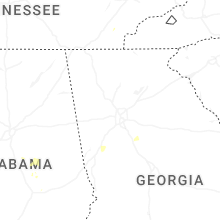
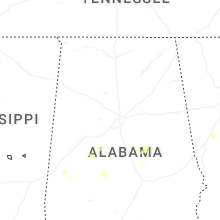
Alabama
| Local Time | Report Details |
|---|---|
| 4:07 PM CDT | Trees down across the road in centrevill in bibb county AL, 44.3 miles SSW of Birmingham, AL |
| 4:50 PM CDT | Tree down on summerfield r in dallas county AL, 35.4 miles NNE of Camden, AL |
Wyoming
| Local Time | Report Details |
|---|---|
| 3:16 PM MDT | Asos station kdgw douglas airport - dg in converse county WY, 48.3 miles E of Casper, WY |
North Carolina
| Local Time | Report Details |
|---|---|
| 5:21 PM EDT | Several trees and utility lines blown down around the town of wilkesboro. time estimated from rada in wilkes county NC, 65.8 miles NNW of Charlotte, NC |
| 5:42 PM EDT | Tree down at intersection of cook school road and cook school road ext. time estimated from rada in surry county NC, 64 miles SSW of Roanoke, VA |
| 6:10 PM EDT | Tree down near the intersection of west dodson road and whitaker chapel roa in surry county NC, 69.1 miles SSW of Roanoke, VA |
| 6:30 PM EDT | Tree down near the intersection of wards gap road and crossingham roa in surry county NC, 61.7 miles SW of Roanoke, VA |
| 8:00 PM EDT | 911 communications reported a tree blocking roadway on lavender roa in cleveland county NC, 38.1 miles W of Charlotte, NC |
| 8:06 PM EDT | Tree down on power lines at shell rd and pilot school rd... resulting in power outage in davidson county NC, 60.2 miles NE of Charlotte, NC |
| 8:57 PM EDT | Trees on power lines at alamance church rd and andrews dairy rd... resulting in power outage in guilford county NC, 60.8 miles WNW of Raleigh, NC |
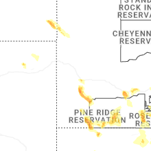
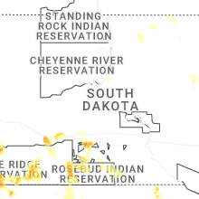
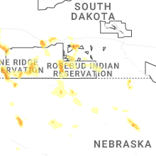
South Dakota
| Local Time | Report Details |
|---|---|
| 3:57 PM MDT | Quarter sized hail reported near Rapid City, SD, 10.3 miles SSW of Rapid City, SD |
| 4:27 PM MDT | Quarter sized hail reported near Hermosa, SD, 17.4 miles SSW of Rapid City, SD, nickel to quarter size hail. |
| 4:30 PM MDT | Quarter sized hail reported near Keystone, SD, 15.7 miles SSW of Rapid City, SD |
| 4:59 PM MDT | Quarter sized hail reported near Hermosa, SD, 23.6 miles S of Rapid City, SD |
| 5:20 PM MDT | Quarter sized hail reported near Fairburn, SD, 30.3 miles SSE of Rapid City, SD |
| 5:25 PM MDT | Half Dollar sized hail reported near Philip, SD, 68.7 miles ESE of Rapid City, SD |
| 5:25 PM MDT | Golf Ball sized hail reported near Philip, SD, 68.8 miles ESE of Rapid City, SD |
| 6:02 PM MDT | Quarter sized hail reported near Kadoka, SD, 71.2 miles WSW of Pierre, SD, estimated dime up to quarter hail. |
| 7:31 PM CDT | Golf Ball sized hail reported near White River, SD, 52.3 miles SSW of Pierre, SD |
| 6:45 PM MDT | Storm damage reported in fall river county SD, 68.3 miles S of Rapid City, SD |
| 6:57 PM MDT | Storm damage reported in oglala lakota county SD, 85.5 miles W of Valentine, NE |
| 8:49 PM CDT | Storm damage reported in tripp county SD, 50.3 miles NE of Valentine, NE |
South Carolina
| Local Time | Report Details |
|---|---|
| 6:27 PM EDT | Power outage attributed to fallen trees or limbs at w parker rd and w marion st. time estimate in greenville county SC, 9.5 miles ENE of Greenville, SC |
| 6:30 PM EDT | Fallen trees or limbs caused power outage on zet court. time estimated from rada in greenville county SC, 9.7 miles E of Greenville, SC |
| 6:38 PM EDT | Downed trees or limbs caused power outages on data bush dr. time estimated from rada in spartanburg county SC, 31.8 miles ENE of Greenville, SC |
| 7:04 PM EDT | Schp reports tree in roadway at woodruff rd and hwy 1 in greenville county SC, 19.4 miles E of Greenville, SC |
Connecticut
| Local Time | Report Details |
|---|---|
| 6:49 PM EDT | In wethersfield a tree fell onto a home on brimfield road. relayed via amateur radi in hartford county CT, 65.6 miles W of Providence, RI |
Montana
| Local Time | Report Details |
|---|---|
| 5:33 PM MDT | Asos station kbzn bozeman yellowstone airpor in gallatin county MT, 9.6 miles NW of Bozeman, MT |
| 5:49 PM MDT | Asos station kbzn bozeman yellowstone airpor in gallatin county MT, 9.6 miles NW of Bozeman, MT |
| 5:56 PM MDT | Asos station kbzn bozeman yellowstone airpor in gallatin county MT, 9.6 miles NW of Bozeman, MT |
| 6:00 PM MDT | Mesonet station mtbzh bozeman pass (mt dot in gallatin county MT, 11.3 miles E of Bozeman, MT |
| 6:21 PM MDT | Corrects previous tstm wnd gst report from 7 ene livingston. asos station klvm livingsto in park county MT, 29.2 miles E of Bozeman, MT |
| 6:46 PM MDT | Asos station klvm livingsto in park county MT, 29.2 miles E of Bozeman, MT |
Colorado
| Local Time | Report Details |
|---|---|
| 7:11 PM MDT | Storm damage reported in washington county CO, 26.7 miles W of Yuma, CO |
Nebraska
| Local Time | Report Details |
|---|---|
| 7:29 PM MDT | Hen Egg sized hail reported near Alliance, NE, 55.3 miles ENE of Scottsbluff, NE, report via social media. |
| 7:50 PM MDT | Hen Egg sized hail reported near Lakeside, NE, 66.1 miles ENE of Scottsbluff, NE, report via social media. |
Connect with Interactive Hail Maps