

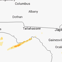
Hail Map for Sunday, April 14, 2013

Number of Impacted Households on 4/14/2013
0
Impacted by 1" or Larger Hail
0
Impacted by 1.75" or Larger Hail
0
Impacted by 2.5" or Larger Hail
Square Miles of Populated Area Impacted on 4/14/2013
0
Impacted by 1" or Larger Hail
0
Impacted by 1.75" or Larger Hail
0
Impacted by 2.5" or Larger Hail


Cities Most Affected by Hail Storms of 4/14/2013
| Hail Size | Demographics of Zip Codes Affected | ||||||
|---|---|---|---|---|---|---|---|
| City | Count | Average | Largest | Pop Density | House Value | Income | Age |
Hail and Wind Damage Spotted on 4/14/2013
Filter by Report Type:Hail ReportsWind Reports
Mississippi
| Local Time | Report Details |
|---|---|
| 8:39 AM CDT | Peak wind 33052kt/1339utc in harrison county MS, 63.8 miles WSW of Mobile, AL |
| 8:53 AM CDT | Multiple trees and power lines down along cuevas-delisle roa in harrison county MS, 57.1 miles ENE of New Orleans, LA |
Alabama
| Local Time | Report Details |
|---|---|
| 9:40 AM CDT | Power line down near grand bay estimated 46 mp in mobile county AL, 22.2 miles SW of Mobile, AL |
| 9:40 AM CDT | Power line knocked over near grand bay. 46 mph estimat in mobile county AL, 22.2 miles SW of Mobile, AL |
| 9:40 AM CDT | Power pole knocked down near grand bay. 46 mph estimat in mobile county AL, 22.2 miles SW of Mobile, AL |
| 10:06 AM CDT | Power lines down on dauphin island parkway at river road. radar measured 45 kt in crenshaw county AL, 61.7 miles E of Camden, AL |
| 10:06 AM CDT | Power lines down on dauphin island parkway at river road. radar measured 45 kt in mobile county AL, 17.3 miles SW of Mobile, AL |
| 10:45 AM CDT | Two large oak trees down against a house in gulf shore in baldwin county AL, 36.7 miles SE of Mobile, AL |
| 11:00 AM CDT | Tree down on route 104 in fairhope. reported by bladwin em in baldwin county AL, 14.7 miles SE of Mobile, AL |
| 11:00 AM CDT | Tree down on route 104. reported by baldwin em in baldwin county AL, 14.7 miles SE of Mobile, AL |
Florida
| Local Time | Report Details |
|---|---|
| 3:35 PM EDT | Trees and powerlines down in eastpoin in franklin county FL, 59.2 miles SW of Tallahassee, FL |
| 3:43 PM EDT | Quarter sized hail reported near Eastpoint, FL, 60.5 miles SW of Tallahassee, FL, quarter size hail and estimated wind gusts of 50 mph. |
| 4:15 PM EDT | Power line down on westcott circle in gulf county FL, 74.5 miles ESE of Miramar Beach, FL |
| 4:59 PM EDT | C tower measured a gust of 55 knots at an elevation of 35 meters above the surface in gmz755 county FL, 79 miles SSW of Tallahassee, FL |
| 5:01 PM EDT | C tower measured gust of 71 knots at an elevation of 35 meters above the surfac in gmz755 county FL, 79 miles SSW of Tallahassee, FL |
| 5:47 PM EDT | Central dispatch reported a tree and power lines down at birch street and lakeview trai in putnam county FL, 49.7 miles SSW of Jacksonville, FL |
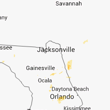
| 6:27 PM EDT | Quarter sized hail reported near Altamonte Springs, FL, 8.5 miles N of Orlando, FL, a trained spotter reported quarter sized hail at 625pm local in altamonte springs. |
| 6:30 PM EDT | Quarter sized hail reported near Ocklawaha, FL, 48.3 miles NW of Orlando, FL, one inch diameter hail ne of ocklawaha |
| 7:25 PM EDT | Central dispatch reported a tree down on nw 66th blv in hamilton county FL, 67.9 miles SSW of Douglas, GA |
| 7:28 PM EDT | Central dispatch reported a tree down on 24th stree in hamilton county FL, 74.6 miles S of Douglas, GA |
| 7:30 PM EDT | Trees and power lines down near chiefland and also near gulf hammoc in levy county FL, 92.6 miles SW of Jacksonville, FL |
| 10:30 PM EDT | One window blown out and lawn furn in brevard county FL, 48.8 miles NNW of Port Saint Lucie, FL |
Oklahoma
| Local Time | Report Details |
|---|---|
| 7:06 PM CDT | Storm damage reported in logan county OK, 41.1 miles N of Oklahoma City, OK |
Georgia
| Local Time | Report Details |
|---|---|
| 8:55 PM EDT | Dispatch reported multiple trees down county-wid in pierce county GA, 40.6 miles ESE of Douglas, GA |
| 9:47 PM EDT | Central dispatch reported numerous trees down in the thalmann are in glynn county GA, 64.9 miles SSW of Savannah, GA |
| 10:03 PM EDT | Police officers reported several large limbs down across the darien area. size of limbs estimated at roughly 4 inches in diameter. time estimated by rada in mcintosh county GA, 52.9 miles SSW of Savannah, GA |
| 10:22 PM EDT | The island manager reported several trees down across the southwestern portion of the island. one tree down on a parked car. damage to numerous aluminium signs. no inju in mcintosh county GA, 42.3 miles SSW of Savannah, GA |
| 10:30 PM EDT | Measured by the national estuarine research system observation site at sapelo islan in mcintosh county GA, 47 miles SSW of Savannah, GA |
Connect with Interactive Hail Maps